U.S. Route 13 in Pennsylvania
| ||||
|---|---|---|---|---|
_map.png) | ||||
| Route information | ||||
| Maintained by PennDOT and City of Philadelphia | ||||
| Length: | 49.328 mi[1] (79.386 km) | |||
| Major junctions | ||||
| South end: |
| |||
|
| ||||
| North end: |
| |||
| Location | ||||
| Counties: | Delaware, Philadelphia, Bucks | |||
| Highway system | ||||
| ||||

U.S. Route 13 (US 13) is a U.S. highway running from Fayetteville, North Carolina north to Morrisville, Pennsylvania. The route runs for 49.33 mi (79.39 km) through the Philadelphia metropolitan area in the U.S. state of Pennsylvania. The route enters the state from Delaware in Marcus Hook, Delaware County. It continues in a northeasterly direction through Delaware County, passing through the city of Chester before heading through suburban areas along Chester Pike to Darby. US 13 enters Philadelphia on Baltimore Avenue and runs through West Philadelphia to University City, where it turns north along several city streets before heading east across the Schuylkill River along Girard Avenue. The route turns north and heads to North Philadelphia, where it runs northeast along Hunting Park Avenue. US 13 becomes concurrent with US 1 on Roosevelt Boulevard, continuing into Northeast Philadelphia. US 13 splits southeast on one-way streets before heading northeast out of the city on Frankford Avenue. The route continues into Bucks County as Bristol Pike, heading northeast to Bristol, where it turns into a divided highway. US 13 becomes a freeway in Tullytown and continues north to its terminus at US 1 near Morrisville. US 13 roughly parallels Interstate 95 (I-95) through its course in Pennsylvania.
The routing dates back to colonial times as part of the King's Highway. In the 19th century, the road was part of several turnpikes, including the Darby and Ridley Turnpike (or Chester Pike) between Chester and Darby and the Frankford and Bristol Turnpike between Philadelphia and Morrisville. In the early 20th century, these private turnpikes became public roads. US 13 was designated through Pennsylvania in 1926, running between the Delaware border in Marcus Hook and US 1 in Morrisville. The route was designated concurrent with Pennsylvania Route 91 (PA 91) between the Delaware border and Philadelphia and PA 32 between Philadelphia and Morrisville; these concurrent state route designations were removed in 1928. US 13 originally ran through Darby on Main Street and Philadelphia on Woodland Avenue, Market Street, Broad Street, Diamond Street, Front Street, Kensington Avenue, and Frankford Avenue. In the 1930s, the route was shifted to use Macdade Boulevard, Whitby Avenue, 44th Street, Powelton Avenue, 31st and 32nd streets, Spring Garden Street, Broad Street, Roosevelt Boulevard, Levick Street, and Frankford Avenue through the city; it ran concurrent with US 1 through most of the city. Between the 1930s and 1960s, three bypass routes existed for portions of US 13 between Marcus Hook and Philadelphia. The divided highway alignment between Bristol and Tullytown was completed by 1950. The US 13 freeway between Tullytown and US 1 was completed in 1955, shifting the northern terminus to its current location. This freeway was once considered to become a part of I-95 that would pass through Trenton, New Jersey before it was decided for the interstate to bypass Trenton to the north. A US 13 freeway was again proposed between I-95 near Bristol and Tullytown in 1969 but was ultimately cancelled. The route was shifted to use 43rd and 44th streets, Powelton Avenue, 34th Street, Girard Avenue, 33rd Street, Ridge Avenue, and Hunting Park Avenue in Philadelphia in the 1950s. US 13 was rerouted to use Church Lane and Baltimore Avenue between Yeadon and West Philadelphia in the 1960s. The route was shifted to its current alignment in the 1970s.
Route description
Delaware County

US 13 enters Pennsylvania from Delaware in the borough of Marcus Hook in Delaware County, heading northeast on four-lane undivided Post Road. From the state line, the route passes through Sunoco's Marcus Hook Industrial Complex . The road narrows to two lanes and crosses a railroad spur serving the industrial complex before it heads into the commercial center of Marcus Hook as 10th Street, intersecting the southern terminus of PA 452. US 13 crosses a Conrail Shared Assets Operations line and runs between residential areas to the north and industrial areas to the south before it crosses the Marcus Hook Creek into the borough of Trainer. The route becomes Post Road again and passes between homes and some businesses to the north and a ConocoPhillips oil refinery to the south before it reaches a junction with the western terminus of PA 291. The road continues through urban residential and industrial areas as it enters the city of Chester, where the road name becomes 4th Street.[2][3]
US 13 passes near urban homes and businesses, turning northwest onto Highland Avenue. The route passes under Amtrak's Northeast Corridor near the Highland Avenue station serving SEPTA's Wilmington/Newark Line before running past more homes and turning northeast onto 9th Street. US 13 continues through urban neighborhoods and passes Community Hospital of Chester. The route comes to an partial interchange with the US 322 freeway providing access to and from the Commodore Barry Bridge over the Delaware River. Following this, the road continues past urban residences and businesses, crossing Chester Creek. US 13 reaches a junction with the southern terminus of PA 352 at Avenue of the States and continues northeast to intersect PA 320, which is routed on the one-way pair of Madison Street northbound and Upland Street southbound. The route turns north onto Morton Avenue and continues through urban development, curving to the northeast.[2][3]
US 13 crosses the Ridley Creek and forms the border between Ridley Township to the north and the borough of Eddystone to the south, widening to four lanes and becoming Chester Pike. The road passes a mix of homes and businesses before it comes to a bridge over Crum Creek, at which point it fully enters Ridley Township. The route passes under I-95 and continues past commercial development, gaining a center left-turn lane. US 13 enters the borough of Ridley Park and passes under the Northeast Corridor near the Crum Lynne SEPTA station before it heads into residential areas and intersects Stewart Avenue, which heads southeast to provide access to I-95. The route continues past suburban homes and businesses as a four-lane undivided road, passing to the southeast of Taylor Hospital. The road forms the border between Ridley Park to the north and Ridley Township to the south before it enters the borough of Prospect Park and comes to an intersection with PA 420. US 13 continues northeast through suburban areas and runs along the border between Prospect Park to the north and the borough of Norwood to the south before continuing through Norwood. The route enters the borough of Glenolden and passes under the Northeast Corridor again. The road runs past more homes and businesses, passing through a small section of the borough of Folcroft before crossing into the borough of Sharon Hill. There, US 13 passes by the Sharon Hill station which serves as the terminus of SEPTA's Route 102 trolley line before continuing past more development. The road curves north at the point it crosses over a short tunnel carrying CSX's Philadelphia Subdivision and enters the borough of Collingdale, continuing to an intersection with Macdade Boulevard.[2][3]
At this point, Chester Pike splits to the east and US 13 continues north along four-lane undivided Macdade Boulevard, crossing Darby Creek into the borough of Darby. The route curves northeast into urban neighborhoods, narrowing to two lanes. The road passes to the south of Holy Cross Cemetery, where it enters the borough of Yeadon, before it passes through more residential areas. US 13 turns north-northwest onto Church Lane and runs through more residential neighborhoods. The route comes to a bridge over SEPTA's Media/Elwyn Line near the Fernwood–Yeadon station and crosses into Upper Darby Township, where it comes to an intersection with Baltimore Pike. Here, US 13 turns east onto Baltimore Pike and passes between Fernwood Cemetery to the north and urban residential and commercial development to the south. Farther east, the road becomes the border between Upper Darby Township to the north and Yeadon to the south.[2][3]
Philadelphia
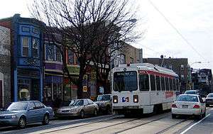
US 13 crosses Cobbs Creek into the West Philadelphia section of the city of Philadelphia, where the name changes to Baltimore Avenue. Immediately after crossing the creek, the road comes to the Angora Loop at 61st Street, which serves as the terminus of SEPTA's Route 34 trolley. At this point, the trolley tracks follow Baltimore Avenue as it continues through urban neighborhoods consisting of rowhomes along with a few businesses. The road curves to the east, passing through more urban development with the Route 34 trolley splitting from Baltimore Avenue at 40th Street, where it heads underground at the 40th Street Portal. The road heads into the University City neighborhood, becoming a four-lane road at the 39th Street intersection as it heads onto the University of Pennsylvania campus. A block later, Baltimore Avenue ends and US 13 turns north onto four-lane divided University Avenue. The route continues north through the university campus and becomes 38th Street as it reaches an intersection with Walnut Street, which is one-way westbound and carries the westbound direction of PA 3. At this point, westbound PA 3 becomes concurrent with southbound US 13, and 38th Street continues north through commercial areas. The road crosses one-way Chestnut Street, which carries eastbound PA 3, before coming to the junction with two-way Market Street, where westbound PA 3 splits from southbound US 13. US 13 continues to follow four-lane divided 38th Street north to Powelton Avenue.[2][4]

At this point, US 13 turns east onto two-lane undivided Powelton Avenue, which is city-maintained. The route crosses Lancaster Avenue and continues into residential areas. US 13 turns north and splits into a one-way pair, running along 33rd Street northbound and 34th Street southbound. The northbound direction carries one lane of traffic while the southbound direction carries two lanes of traffic. The route follows 33rd and 34th streets north through the Mantua neighborhood, passing homes and a few businesses. At Mantua Avenue, northbound US 13 turns northwest to rejoin the southbound direction on 34th Street. Upon rejoining, US 13 continues north on four-lane undivided 34th Street and comes to a bridge over several tracks along Amtrak's Northeast Corridor before running between the Philadelphia Zoo to the west and the Schuylkill Expressway (I-76/US 30) to the east. US 13 continues north to Girard Avenue, where it comes to interchange ramps with the Schuylkill Expressway. At this point, US 30 splits from the Schuylkill Expressway and heads west on Girard Avenue while US 13 turns east from 34th Street onto Girard Avenue, becoming state-maintained again. US 13 heads east along Girard Avenue, which carries four lanes of traffic and SEPTA's Route 15 trolley line. The Girard Avenue Bridge carries the route over the Schuylkill Expressway, the Schuylkill River, and Kelly Drive on the other side of the river. Past the bridge, the road enters Fairmount Park and ramps provide access to Kelly Drive.[2][4]
US 13 splits from Girard Avenue and turns north onto two-lane undivided 33rd Street. The route comes to bridges over CSX's Trenton Subdivision and the Northeast Corridor tracks before it runs between wooded Fairmount Park to the west and the urban Strawberry Mansion neighborhood to the east, intersecting Cecil B. Moore Avenue. The road passes to the east of East Park Reservoir before it comes to Ridge Avenue. At this point, US 13 turns northwest onto four-lane undivided Ridge Avenue and continues between the park to the west and urban homes to the east before it runs between the Laurel Hill Cemetery to the west and Mount Vernon Cemetery to the east. The route reaches an interchange with Hunting Park Avenue that provides access to Kelly Drive to the west, at which point the route splits from Ridge Avenue and heads northeast onto four-lane undivided Hunting Park Avenue. The road continues into North Philadelphia and heads into urban areas of homes, businesses, and industry, crossing Allegheny Avenue before reaching bridges under SEPTA's Manayunk/Norristown Line and Chestnut Hill West Line. US 13 continues into the Nicetown–Tioga neighborhood and intersects Erie Avenue before it crosses under SEPTA's Main Line. The route intersects Germantown Avenue and comes to a bridge over Conrail Shared Assets Operations' Port Richmond Branch before Hunting Park Avenue splits to the east, at which point the route becomes Roosevelt Boulevard. US 13 follows Roosevelt Boulevard through commercial areas and crosses PA 611 (Broad Street) before it comes to an interchange with US 1 (Roosevelt Expressway) and merges onto the northbound direction of that route to the north of the Hunting Park neighborhood.[2][4]
At this point, US 1 becomes concurrent with US 13 on Roosevelt Boulevard, a wide boulevard with local-express lanes that has 12 lanes total in a 3-3-3-3 configuration. Along the Roosevelt Boulevard, access between the inner and outer carriageways is provided with narrow crossover ramps immediately between them; for most intersections, left turns are only permitted from the inner pair (or from separate left turn roadways) and right turns only from the outer, and crossing between them is not permitted at the intersections. The boulevard continues past urban residential neighborhoods, coming to the 5th Street junction, where the local lanes intersect at-grade and the express lanes pass over the street on a bridge. US 1/US 13 continues east and passes through the Feltonville neighborhood, where it intersects Rising Sun Avenue, before it crosses the Tacony Creek. At this point, Roosevelt Boulevard continues into Northeast Philadelphia and curves to the southeast, passing between a shopping center to the northeast and Friends Hospital to the southwest. The boulevard curves to the northeast again and passes near rowhomes before reaching the Oxford Circle. At this point, the local lanes pass through the Oxford Circle, a traffic circle at Cheltenham Avenue and the southern terminus of PA 232, which runs along Oxford Avenue. The express lanes pass under the Oxford Circle. Past the circle, Roosevelt Boulevard continues east-northeast through residential areas.[2][4]

US 13 splits from US 1 and the Roosevelt Boulevard by heading southeast on the one-way pair of Robbins Street northbound and Levick Street southbound, with Robbins Street carrying two lanes of one-way traffic and Levick Street carrying three lanes of one-way traffic. The route follows Robbins and Levick streets through residential neighborhoods, crossing Harbison Avenue before reaching Frankford Avenue. At this point, both directions of US 13 continue northeast on Frankford Avenue, a four-lane undivided road, while Robbins and Levick streets continue southeast towards the Tacony-Palmyra Bridge. The road passes through business areas and heads into the Mayfair neighborhood, where it intersects PA 73 at Cottman Avenue. The route continues into the Holmesburg neighborhood and runs through more commercial areas. US 13 passes under Conrail Shared Assets Operations' Bustleton Branch and crosses the Pennypack Creek in a wooded area on the Frankford Avenue Bridge. After this, the route becomes a three-lane road with a center left-turn lane that passes a mix of homes and businesses in the Torresdale neighborhood, intersecting Academy Road. The road continues through developed areas and intersects Grant Avenue and Knights Road.[2][4]
Bucks County

US 13 crosses the Poquessing Creek into Bensalem Township in Bucks County, where the name becomes Bristol Pike. The road runs northeast past suburban homes and businesses in the community of Andalusia before it widens into a divided highway in a commercial area and reaches an interchange with the PA 63 freeway (Woodhaven Road) a short distance northwest of I-95. Past this, the route gains a center left-turn lane and comes to an intersection with the southern terminus of PA 513. US 13 continues past a mix of residences and commercial establishments in the community of Cornwells Heights. Farther northeast, the road comes to an interchange with PA 132 immediately northwest of that route's eastern terminus at I-95. Following PA 132, US 13 continues past businesses immediately to the northwest of I-95. The route intersects Bensalem Boulevard and curves east to pass under I-95 before coming to a bridge over Neshaminy Creek. Upon crossing the creek, the road enters Bristol Township and heads into the community of Croydon, where it passes businesses and runs to the north of the Croydon station along SEPTA's Trenton Line that follows Amtrak's Northeast Corridor. US 13 continues east between residential neighborhoods to the north and the Northeast Corridor railroad tracks immediately to the south. Farther east, the road passes to the south of a cemetery before reaching a junction with PA 413.[2][5]
Following this intersection, the route enters the borough of Bristol and widens into a four-lane divided highway with multiple intersections controlled by jughandles, heading northeast through business areas further from the railroad tracks. The road briefly passes through Bristol Township as it heads south of Silver Lake and curves northeast. US 13 continues through the northern part of the borough of Bristol, running through commercial areas and passing to the west of residential neighborhoods. The route reenters Bristol Township and passes through commercial areas with some woods before coming to a trumpet interchange that provides access to the Pennsylvania Turnpike (I-276) at the Delaware Valley interchange. Past this ramp, the road passes through commercial areas and crosses an East Penn Railroad line before passing under the Delaware River–Turnpike Toll Bridge which carries the Pennsylvania Turnpike over the Delaware River, where it connects to the Pearl Harbor Memorial Extension of the New Jersey Turnpike. US 13 crosses the Delaware Canal and runs past more businesses. The route crosses into the borough of Tullytown and passes between the Levittown Town Center to the west and the Levittown station serving SEPTA's Trenton Line on the adjacent Northeast Corridor to the east.[2][5]
Bristol Pike splits off to the northeast and US 13 heads north as a freeway, forming the border between Tullytown to the west and Falls Township to the east. The freeway fully enters Falls Township and has a partial interchange with Mill Creek Road, with a northbound exit and entrance and a southbound exit. Following this, the route passes between the planned residential suburb of Levittown to the west and Falls Township Community Park to the east. US 13 intersects Penn Valley Road at a full diamond interchange before it heads northeast through woods and comes to a cloverleaf interchange with Tyburn Road. The freeway curves north and has an interchange with Lower Morrisville Road before it passes over Conrail Shared Assets Operations' Morrisville Yard. After this, US 13 reaches its northern terminus at an interchange with the US 1 freeway to the west of Morrisville. Past this interchange, the freeway ends and the road continues north as Pine Grove Road towards Yardley.[2][5]
History
The roadway between Marcus Hook and Morrisville via Philadelphia was originally part of the King's Highway, a colonial road named in honor of King Charles II of England.[6][7] The King's Highway bridge over the Pennypack Creek in what is now Northeast Philadelphia was built in 1697 and is the oldest bridge in continuous use in the United States.[7] During the reign of Queen Anne, it was called the Queen's Highway. After the British surrendered in the Siege of Yorktown in 1781, the road between Marcus Hook and Darby became known as the Great Southern Post Road as it served as a post road. This section of road has also been known as the Darby-Chester Road and Plank Road. In 1851, the roadway between Chester and Darby was chartered by the state as the Darby and Ridley Turnpike or the Chester Pike, a privately owned turnpike. The turnpike was a plank road with tolls collected at multiple toll houses along the route. In 1921, the state and Delaware County took over the turnpike with each paying $50,000. Improvements to the road between Chester and Darby were completed on August 12, 1926.[6] What is now Baltimore Pike and Baltimore Avenue was originally chartered as the Philadelphia, Brandywine, and New London Turnpike on March 24, 1808, later becoming known as the Delaware County Turnpike.[8] On May 13, 1803, the Philadelphia, Frankford, and Bristol Turnpike was chartered.[9] This turnpike ran between Front Street in Philadelphia and a ferry across the Delaware River in Morrisville via Frankford and Bristol.[7] The Frankford and Bristol Turnpike was completed in 1812.[9] The Frankford and Bristol Turnpike was sold to the city of Philadelphia on July 1, 1892, with trolley service introduced in 1895.[10] The trolley line along Frankford Avenue was replaced with trolleybuses in 1955, which is today SEPTA's Route 66 service.[11][12]
| |
|---|---|
| Location: | Marcus Hook – Philadelphia |
| Existed: | 1927–1930 |
When the Sproul Road Bill was passed in 1911, the road between Chester and Philadelphia was legislated as part of Legislative Route 180 and as Legislative Route 150 between Philadelphia and Morrisville.[13] With the creation of the U.S. Highway System in 1926, US 13 was designated through Pennsylvania from the Delaware border in Marcus Hook northeast to US 1/PA 1 at Bridge Street in Morrisville.[14] The route followed Post Road between Marcus Hook and Chester, Chester Pike between Chester and Darby, and Main Street through Darby before it reached Philadelphia. US 13 passed through Philadelphia along Woodland Avenue, Market Street, Broad Street, Diamond Street, Front Street, Kensington Avenue, and Frankford Avenue. The route continued into Bucks County and followed Bristol Pike to Morrisville, where it headed north on Philadelphia Avenue and Pennsylvania Avenue to US 1. In Philadelphia, US 13 ran concurrent with US 1 on Woodland Avenue north of Baltimore Avenue, US 1 and US 30 on Market Street and Broad Street north to Vine and Race streets, and US 1 on Broad Street between Vine Street and Diamond Street.[14][15][16] US 13 was originally designated concurrent with PA 91 between the Delaware border and Philadelphia and with PA 32 between Philadelphia and Morrisville, where that route continued north along the Delaware River.[17] In 1928, the concurrent PA 91 and PA 32 designations were removed.[18]
In the 1930s, US 13 was rerouted to a new alignment through Philadelphia. The route followed Macdade Boulevard between Darby and Yeadon, where it entered Philadelphia on Whitby Avenue and continued northeast to an intersection with US 1 (Baltimore Avenue). At this point, US 13 became concurrent with US 1 and the two routes followed Baltimore Avenue, 44th Street, Powelton Avenue, the one-way pair of 31st Street northbound and 32nd Street southbound, and Spring Garden Street to a junction with US 30 at the Eakins Oval. The two routes ran east with US 30 on Spring Garden Street before turning north onto Broad Street towards North Philadelphia. US 1 and US 13 followed the Roosevelt Boulevard northeast as a bypass route, running concurrent with US 422 between Tabor Street and Levick Street. At Levick Street, US 13 and US 422 split from US 1 by heading southeast on Levick Street. US 13 split from US 422 by turning northeast onto Frankford Avenue, running concurrent with PA 73 between Levick Street and Cottman Avenue. In addition, a bypass route known as US 13 Byp. was created, bypassing the central part of Philadelphia to the north and west.[19] By 1950, two bypass routes were designated for US 13 in Delaware County. The first US 13 Byp. bypassed the portion between Marcus Hook and Chester while the second US 13 Byp. served as a bypass of the portion of the route that followed Chester Pike between Chester and Darby.[20][21]

US 13 was realigned to a new divided highway alignment of Bristol Pike between PA 413 in Bristol and Tullytown by 1950, having previously followed what is now Old Route 13, Pond Street, Farragut Avenue, Radcliffe Street, Main Street, and Fallsington Avenue between the two boroughs.[22][23] In 1954, the US 13 freeway was built between Tyburn Road and US 1.[24][25] A year later, the freeway was completed between Tullytown and Tyburn Road, at which point US 13 was rerouted to follow the freeway to US 1.[26][27][28] The US 13 freeway was planned to be incorporated into I-95, which would head northeast from its current routing at PA 413 and continue along the US 13 alignment to US 1, where it would follow that route across the Delaware River on the Trenton-Morrisville Toll Bridge and through Trenton, New Jersey. However, this plan was opposed by New Jersey officials and I-95 was instead routed to bypass Trenton to the north, crossing the Delaware River on the Scudder Falls Bridge.[29] Plans resurfaced for an extension of the US 13 freeway in 1969 that would run from I-95 at the PA 413 interchange northeast to the south end of the current freeway in Tullytown, interchanging with the Pennsylvania Turnpike (I-276). This freeway was projected to cost $12.5 million.[30] This freeway, which would have provided a missing connection between I-95 and the Pennsylvania Turnpike, was never built because it would have impacted Silver Lake Park.[31]
In the 1950s, US 13 was shifted in Philadelphia to run along the one-way pair of 43rd Street northbound and 44th Street southbound from Baltimore Avenue, Powelton Avenue, 34th Street, Girard Avenue (where it ran concurrent with US 30), 33rd Street, Ridge Avenue, and Hunting Park Avenue (where it ran concurrent with US 1) to Roosevelt Boulevard. The US 1 concurrency south of Hunting Park Avenue was removed, with US 1 shifted to an alignment further to the west concurrent with US 13 Byp. US 13 was also split into a one-way pair along Robbins and Levick streets.[32] The concurrency with US 1 along Hunting Park Avenue was removed in the 1960s after that route was shifted to the Roosevelt Expressway; the PA 73 concurrency along Frankford Avenue was also removed. US 13 was also rerouted to use Church Lane and Baltimore Avenue between Yeadon and West Philadelphia instead of following Macdade Boulevard and Whitby Avenue.[33] In the 1970s, US 13 was shifted to use 38th Street to travel between Baltimore and Powelton avenues.[34]
Major intersections
| County | Location | mi[1] | km | Destinations | Notes | |
|---|---|---|---|---|---|---|
| Delaware | Marcus Hook | 0.000 | 0.000 | Delaware border | ||
| 1.090 | 1.754 | |||||
| Trainer | 2.179 | 3.507 | ||||
| Chester | 3.720 | 5.987 | Interchange | |||
| 5.189 | 8.351 | |||||
| 5.311 | 8.547 | |||||
| 5.397 | 8.686 | |||||
| Prospect Park | 8.864 | 14.265 | ||||
| Philadelphia | Philadelphia | 18.011 | 28.986 | South end of PA 3 west overlap | ||
| 18.118 | 29.158 | |||||
| 18.224 | 29.329 | North end of PA 3 west overlap | ||||
| 19.948 | 32.103 | I-76 Exit 342; Brief overlap between US 13 northbound and US 30 westbound | ||||
| Girard Avenue Bridge over the Schuylkill River | ||||||
| 21.993 | 35.394 | Ridge Avenue / Kelly Drive | Interchange | |||
| 24.356 | 39.197 | |||||
| 24.653 | 39.675 | Interchange; south end of US 1 overlap; southbound exit and northbound entrance | ||||
| 28.105 | 45.231 | Interchange (Oxford Circle) | ||||
| 28.837 | 46.409 | North end of US 1 overlap | ||||
| 30.820 | 49.600 | |||||
| Bucks | Bensalem Township | 35.764 | 57.557 | Partial cloverleaf interchange | ||
| 36.029 | 57.983 | |||||
| 37.456 | 60.280 | Partial cloverleaf interchange | ||||
| Bristol | 40.945 | 65.895 | ||||
| Bristol Township | 42.970 | 69.154 | I-276 / Penna Turnpike Exit 358 (Delaware Valley), future I-95 Exit 43 | |||
| Falls Township | 45.358 | 72.997 | South end of freeway | |||
| 46.415 | 74.698 | Mill Creek Road | ||||
| 47.361 | 76.220 | Penn Valley Road | ||||
| 48.086 | 77.387 | Tyburn Road | Cloverleaf interchange | |||
| 49.078 | 78.983 | Lower Morrisville Road | ||||
| 49.294 | 79.331 | Northbound exit and southbound entrance | ||||
| 49.328 | 79.386 | Pine Grove Road - Yardley | Northern terminus; Pine Grove Road continues beyond US 1 | |||
1.000 mi = 1.609 km; 1.000 km = 0.621 mi
| ||||||
See also
 U.S. Roads portal
 Pennsylvania portal
 Philadelphia portal
References
| Wikimedia Commons has media related to U.S. Route 13 in Pennsylvania. |
- 1 2 Bureau of Maintenance and Operations (January 2015). Roadway Management System Straight Line Diagrams (Report) (2015 ed.). Pennsylvania Department of Transportation. Retrieved June 30, 2015.
- Delaware County (PDF)
- Philadelphia County (PDF)
- Bucks County (PDF)
- 1 2 3 4 5 6 7 8 9 10 11 12 Google (January 18, 2015). "U.S. Route 13 in Pennsylvania" (Map). Google Maps. Google. Retrieved January 18, 2015.
- 1 2 3 4 Delaware County, Pennsylvania Highway Map (PDF) (Map). PennDOT. 2014. Retrieved January 18, 2015.
- 1 2 3 4 5 Philadelphia County, Pennsylvania Highway Map (PDF) (Map). PennDOT. 2014. Retrieved January 11, 2015.
- 1 2 3 Bucks County, Pennsylvania Highway Map (PDF) (Map). PennDOT. 2014. Retrieved January 18, 2015.
- 1 2 O'Neill, Robert F. (January 5, 1992). "History's Bumpy Ride Down Chester Pike George Washington Slipped Here. He Got Out Of The Rut - And So Did The Road, As Its Name And Conditions Kept Changing.". The Philadelphia Inquirer. Retrieved January 19, 2015.
- 1 2 3 Iatarola, Louis M., Iatarola, Lynn-Carmela T. (2008). Lower Northeast Philadelphia. Charleston, SC: Arcadia Publishing. p. 27-28. Retrieved January 19, 2015.
- ↑ Jordan, John Woolf (1914). A History of Delaware County, Pennsylvania, and Its People. 1. New York, NY: Lewis Historical Publisher Company. p. 313. Retrieved January 19, 2015.
- 1 2 Carey, E.L., Hart, A. (1835). Picture of Philadelphia. Applewood's American Cities Series. Carlisle, MA: Applewood Books. p. 217. Retrieved January 19, 2015.
- ↑ City History Society of Philadelphia (1917). Publications [or Publication] of the City History Society of Philadelphia. 1. Philadelphia, PA: City History Society of Philadelphia. p. 251. Retrieved January 19, 2015.
- ↑ Springirth, Kenneth C. (2008). Southeastern Pennsylvania Trolleys. Charleston, SC: Arcadia Publishing. p. 10, 115–116. ISBN 978-0-7385-5692-5.
- ↑ "Route 66 bus map" (PDF). SEPTA. Retrieved January 19, 2015.
- ↑ Map of Pennsylvania Showing State Highways (PDF) (Map). Pennsylvania Department of Highways. 1911. Retrieved December 14, 2014.
- 1 2 Pennsylvania Highway Map (eastern side) (Map). Gulf Oil. 1926. Retrieved December 26, 2007.
- ↑ Tourist Map of Pennsylvania (PDF) (Map). Pennsylvania Department of Highways. 1930. Retrieved January 1, 2014.
- ↑ Tourist Map of Pennsylvania (back) (PDF) (Map). Pennsylvania Department of Highways. 1930. Retrieved 2007-11-08.
- ↑ Pennsylvania Highway Map (Map). Pennsylvania Department of Highways. 1927. Retrieved December 26, 2007.
- ↑ Map of Pennsylvania (Map). Pennsylvania Department of Highways. 1928. Retrieved May 7, 2015.
- ↑ Official Road Map of Pennsylvania (back) (PDF) (Map). Pennsylvania Department of Highways. 1940. Retrieved January 1, 2014.
- ↑ General Highway Map Delaware County, Pennsylvania (PDF) (Map). Pennsylvania Department of Highways. 1950. Retrieved January 14, 2014.
- ↑ Official Road Map of Pennsylvania (back) (PDF) (Map). Pennsylvania Department of Highways. 1950. Retrieved January 16, 2014.
- ↑ Map of the Public Roads in Bucks County, Pennsylvania (PDF) (Map). Pennsylvania Department of Highways. 1945. Retrieved January 20, 2015.
- ↑ General Highway Map Bucks County, Pennsylvania (Sheet 1) (PDF) (Map). Pennsylvania Department of Highways. 1950. Retrieved January 20, 2015.
- ↑ Federal Highway Administration (2012). "NBI Structure Number: 000000000006773". National Bridge Inventory. Federal Highway Administration.
- ↑ Federal Highway Administration (2012). "NBI Structure Number: 000000000006776". National Bridge Inventory. Federal Highway Administration.
- ↑ Federal Highway Administration (2012). "NBI Structure Number: 000000000006770". National Bridge Inventory. Federal Highway Administration.
- ↑ Federal Highway Administration (2012). "NBI Structure Number: 000000000006771". National Bridge Inventory. Federal Highway Administration.
- ↑ Official Map of Pennsylvania (PDF) (Map). Pennsylvania Department of Highways. 1960. Retrieved December 17, 2014.
- ↑ Interstate 95. Delaware Valley Regional Planning Commission. 1979.
- ↑ 1985 Regional Transportation Plan (Report). Delaware Valley Regional Planning Commission. 1969. OCLC 25700082.
- ↑ Pennsylvania Turnpike / Interstate 95 Interchange Project: Draft Environmental Impact and Section 4(f) Statement (Report). Federal Highway Administration, Pennsylvania Department of Transportation, and Pennsylvania Turnpike Commission. 2001.
- ↑ Official Map of Pennsylvania (back) (PDF) (Map). Pennsylvania Department of Highways. 1960. Retrieved January 16, 2014.
- ↑ Official Map of Pennsylvania (back) (PDF) (Map). Pennsylvania Department of Highways. 1970. Retrieved December 16, 2014.
- ↑ Pennsylvania Official Transportation Map (back) (PDF) (Map). Pennsylvania Department of Transportation. 1980. Retrieved January 17, 2014.
| Previous state: Delaware |
Pennsylvania | Next state: Terminus |