Interstate 95 in Pennsylvania
| ||||
|---|---|---|---|---|
| Delaware Expressway | ||||
.svg.png) | ||||
| Route information | ||||
| Maintained by PennDOT | ||||
| Length: | 51.013 mi[1] (82.097 km) | |||
| Major junctions | ||||
| South end: |
| |||
| ||||
| North end: |
| |||
| Location | ||||
| Counties: | Delaware, Philadelphia, Bucks | |||
| Highway system | ||||
| ||||
Interstate 95 (I-95) is an Interstate highway running from Miami, Florida, north to Houlton, Maine. In the U.S. state of Pennsylvania, the route is known by many as the Delaware Expressway, but is officially named The Vietnam Veterans Memorial Highway.[2] and locally known as "95".[3] It runs 51 miles (82 km) from the Delaware state line near Marcus Hook to the New Jersey state line crossing the Delaware River near Yardley on the Scudder Falls Bridge. It parallels its namesake Delaware River for its entire route through the city of Philadelphia and its suburbs. It is a major route through the city and the metropolitan Delaware Valley, providing access to locally important landmarks such as Philadelphia International Airport, the Philadelphia Sports Complex, Talen Energy Stadium, Penn's Landing, and Philadelphia Mills. Of the 15 states that Interstate 95 runs through, Pennsylvania is the only one that does not border the Atlantic Ocean.
Plans for a limited-access route along the Delaware River in the Philadelphia area originated in the 1930s when both a parkway and elevated highway were proposed; neither of these were built. The Delaware Expressway was approved in 1945 as a toll road that was to be part of the Pennsylvania Turnpike system until the project was turned to the Pennsylvania Department of Highways in 1956, with the expressway to be included in the Interstate Highway System as part of I-95. Construction on I-95 began in 1959 and was mostly complete by 1979, with the final portion near the Philadelphia International Airport finished in 1985. The route was originally projected to run through the center of Trenton, New Jersey, but was rerouted to the Scudder Falls Bridge due to limited capacity in Trenton. In March 2008, large cracks were discovered on a bridge support column in Philadelphia, requiring a two-mile section of the route to be closed for two days. Bridges are planned to be rebuilt along the section of I-95 between Center City and Woodhaven Road (Pennsylvania Route 63) and an interchange is planned to be built with the Pennsylvania Turnpike (Interstate 276) where I-95 will be rerouted to follow the Pennsylvania Turnpike to the New Jersey Turnpike and Interstate 295 will be extended along the current portion of I-95 north of the proposed interchange, with an extension of Interstate 195 having been proposed between 2005 and 2015.
Route description
Interstate 95 passes through the Philadelphia metropolitan area, with much of the route in Philadelphia itself. Interstate 95 runs through a large portion of Philadelphia, most among the other major cities that I-95 serves. It passes under the Benjamin Franklin Bridge and near five other ones (the Commodore Barry, Betsy Ross, Walt Whitman, Tacony-Palmyra and the Burlington-Bristol Bridges) and crosses into New Jersey at the Scudder Falls Bridge.
Interstate 95 enters Delaware County, Pennsylvania, from Delaware near Marcus Hook, just north of its junction with the northern end of Interstate 495. The route interchanges with Chichester Avenue and Pennsylvania Route 452 before meeting U.S. Route 322. I-95 forms a concurrency with US 322 that lasts until that route heads east for the Commodore Barry Bridge. I-95 continues through Chester, interchanging with Kerlin Street and Pennsylvania Route 320/Pennsylvania Route 352 before coming to the southern end of Interstate 476 at the edge of the city. It continues in an eastward direction paralleling Pennsylvania Route 291 through the suburbs of Essington and Tinicum, interchanging with Stewart Avenue and Pennsylvania Route 420. The road enters Philadelphia, where it comes to an interchange with PA 291 that has access to the Philadelphia International Airport. East of the airport, I-95 crosses the Schuylkill River on the double-decker Girard Point Bridge.[4][5]
_Exit_9B.JPG)
Past the Schuylkill River, I-95 continues east into South Philadelphia as an elevated freeway, passing south of the Philadelphia Sports Complex and north of the Philadelphia Navy Yard, interchanging with Pennsylvania Route 611 (Broad Street). The road curves north, following the bend in the Delaware River, and runs along the waterfront, interchanging with Interstate 76 west of the Walt Whitman Bridge. The elevated roadway gradually lowers to a depressed level approaching Center City, where it passes through several short tunnels at Penn's Landing, passes under the Ben Franklin Bridge, and interchanges with the Vine Street Expressway (Interstate 676 and U.S. Route 30). North of Center City, the SEPTA Market-Frankford Line rises up from the Market Street subway into I-95's median as the highway returns to an elevated alignment, entering one station (Spring Garden) before diverging once more. I-95 continues through Northeast Philadelphia, interchanging with the Betsy Ross Bridge and Pennsylvania Route 73 at the Tacony-Palmyra Bridge before crossing the county line into Bucks County.[4][5]
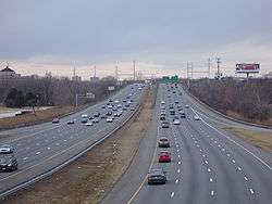
North of the city, I-95 interchanges with the Woodhaven Road expressway (Pennsylvania Route 63) and Pennsylvania Route 132 in Bensalem Township before heading into Bristol Township, where it comes to an interchange with a short expressway stub to Pennsylvania Route 413, a remnant of the unbuilt Interstate 895.[6] It continues north past the future site of the Pennsylvania Turnpike/Interstate 95 Interchange Project, where it currently passes over the Pennsylvania Turnpike (Interstate 276); the two highways were not built to connect with one another. North of I-276, I-95 interchanges with U.S. Route 1 Business/Pennsylvania Route 413 and U.S. Route 1. The route heads into Lower Makefield Township, where it has interchanges with Pennsylvania Route 332 and Taylorsville Road (which provides access to Pennsylvania Route 32) before crossing the Delaware River into New Jersey on the Scudder Falls Bridge.[4][5] This current bridge structure, while structurally sufficient, is functionally obsolete due to high traffic levels and is slated to be improved.[7] An estimated 169,000 motorists utilize the road daily.[8]
History
Plans for a limited-access highway along the Delaware River originated in 1932, as part of a proposed cars-only parkway system for the Philadelphia area similar to the contemporary system being built in New York City. However, planning for the proposed parkway system stalled and the plan was eventually abandoned. In 1937, plans for the highway were revived as the "Delaware Skyway", a planned elevated highway along the waterfront similar in design to the West Side Highway in New York, though these plans were also scrapped due to concerns that the supports would hinder access to port operations on the waterfront.[2][9]
In 1945, the city approved the current routing as the Delaware Expressway, envisioned to link all the industrial areas along the river with the Industrial Highway and the Trenton-Morrisville Toll Bridge to New Jersey. The planned highway was incorporated into the Pennsylvania Turnpike system, and was planned to be built as a toll road. However, with the advent of the Interstate Highway System in 1956, the project was turned over to the Pennsylvania Department of Highways and incorporated into Interstate 95. Construction on the road commenced in 1959.[2][9]
Original plans called for the expressway to follow the U.S. Route 13 corridor to the Trenton-Morrisville Toll Bridge, where I-95 would continue north along today's Trenton Freeway. However, due to limited capacity of the highway through Trenton, planners instead opted to build a new alignment bypassing Trenton to the west, incorporating the existing Scudder Falls Bridge.[2][9]
Controversy erupted in the early 1960s over the planned eight-lane elevated segment of the highway along the Center City waterfront; residents of the upscale Society Hill neighborhood objected to the highway on the grounds that it would cut off the neighborhood from the river. State highway officials reached a compromise by opting for an alternative depressed design with an overhead concrete deck connecting Center City to a planned redeveloped waterfront today known as Penn's Landing. By 1979, the entire length of the expressway was open to traffic with the exception of a four-mile (6 km) segment near Philadelphia International Airport.[2][9]
Completion of the final section of the highway faced considerable difficulty, as the road was to be built on a layer of clay separating the city's water supply from the output of its sewage treatment plant. Matters were complicated by a two-year suspension of federal highway funding while the state failed to implement a federally mandated emissions testing program. This final segment was opened to traffic in 1985, marking the completion of the 35-year project.[2][9]
On March 18, 2008, two miles (3 km) of I-95 within Philadelphia were forced to be closed when PennDOT discovered large cracks in a support column underneath the highway. In order to prevent possible collapse, I-95 was closed between Exit 23 (Girard Avenue) and Exit 25 (Allegheny Avenue). PennDOT worked quickly to stiffen the support beams to allow the road to be raised off the column, using 16 jacks, early on March 20. PennDOT reopened the road shortly thereafter, and plans to replace the cracked column.[10]
Future
A project is currently underway to build an interchange between I-95 and the Pennsylvania Turnpike (Interstate 276) where the two highways cross but do not currently connect with each other.[11] Following the completion of the project, the Pennsylvania Turnpike east of the interchange will be redesignated I-95 to connect with the New Jersey Turnpike portion of the route, while the current I-95 north of the interchange will become part of an extended I-295. The original plan had called for I-295 to be extended into Pennsylvania to the new interchange, but in 2005 plans were changed to extend I-195 into Pennsylvania to the new interchange.[12][13] On May 20, 2015, the plans reverted to extend I-295 into Pennsylvania.[13] Groundbreaking for the interchange took place on July 30, 2013, with Governor Tom Corbett in attendance.[14] Construction of the first stage of the interchange began in fall 2014.[15] The flyover ramps between northbound I-95 and the eastbound turnpike, and between the westbound turnpike and southbound I-95 are due to be completed by 2018. In 2020, construction is expected to begin on completion of the movements between the turnpike and I-95.[16]
_to_future_Interstate_95_(Pennsylvania_Turnpike%2C_currently_Interstate_276)_in_Bristol_Township%2C_Pennsylvania.jpg)
In addition, PennDOT is currently rebuilding all of the I-95 bridges in Philadelphia between Cottman Avenue (PA 73) and the Benjamin Franklin Bridge, in which I-95 will have a total of eight lanes between Central Philadelphia and the Academy Road exit. The project was planned well in advance of the I-35W Mississippi River bridge collapse and will replace bridge spans that were built in the 1960s.[17]
Some have proposed removing the freeway, thereby allowing Philadelphians better access to the Delaware River.[18] On December 31, 2015, outgoing Philadelphia Mayor Michael Nutter announced that a million study funded by state and federal money would consider placing I-95 in a tunnel in the area around Penn's Landing.[19]
Exit list
| County | Location | mi[1] | km | Old exit [20] | New exit [20] | Destinations | Notes |
|---|---|---|---|---|---|---|---|
| Delaware | Lower Chichester Township | 0.000 | 0.000 | – | – | Continuation into Delaware | |
| 0.025 | 0.040 | – | 11 | Southbound exit and northbound entrance partially located in Delaware | |||
| 0.598 | 0.962 | Welcome center and weigh station (northbound only) | |||||
| Upper Chichester Township | 1.157 | 1.862 | 1 | 1 | Chichester Avenue | ||
| 1.679 | 2.702 | 2 | 2 | ||||
| Chester | 2.919 | 4.698 | 3A | 3A | South end of US 322 overlap; southbound exit and northbound entrance | ||
| 3.003 | 4.833 | 3B | 3B | Highland Avenue | Signed as exit 3 northbound | ||
| 3.788 | 6.096 | 4 | 4 | Northern terminus of concurrency with US 322 | |||
| 4.651 | 7.485 | 5 | 5 | Kerlin Street | Northbound exit and southbound entrance | ||
| 5.412 | 8.710 | 6 | 6 | Widener University | |||
| 6.636 | 10.680 | 7 | 7 | Southern terminus of Interstate 476 | |||
| Ridley Park | 7.755 | 12.480 | 8 | 8 | Ridley Park | Access via Stewart Avenue, to Harrah's Philadelphia | |
| Tinicum Township | 8.984 | 14.458 | 9 | 9 | Signed as exits 9A (south) and 9B (north) | ||
| 10.253 | 16.501 | 10 | 12B | Signed as exit 10 northbound; originally planned as southern terminus of Industrial Expressway[21] | |||
| Philadelphia | Philadelphia | 11.561 | 18.606 | 11 | 12A | Signed as exit 12 northbound | |
| 13.076 | 21.044 | 11 | 13 | Northbound exit and southbound entrance | |||
| 13.980 | 22.499 | 12 | 14 | Bartram Avenue / Essington Avenue | Southbound exit and northbound entrance | ||
| 14.424 | 23.213 | 13 | 15 | Enterprise Avenue / Island Avenue | Southbound exit and northbound entrance | ||
| Schuylkill River | Girard Point Bridge | ||||||
| Philadelphia | 16.495 | 26.546 | 14 | 17 | |||
| 18.534 | 29.828 | 15 | 19 | ||||
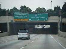
| 19.964 | 32.129 | 16 | 20 | Columbus Boulevard / Washington Avenue | |||
| 21.943 | 35.314 | 17 | 22 | ||||
| 22.972 | 36.970 | 18 | 23 | Girard Avenue / Lehigh Avenue / Delaware Avenue | Originally planned eastern terminus for the Girard Avenue Expressway[22] | ||
| 24.793 | 39.900 | 19 | 25 | Allegheny Avenue / Castor Avenue | |||
| 25.361 | 40.815 | 20 | 26 | Originally planned interchange with the Pulaski Expressway[23] | |||
| 26.320 | 42.358 | 21 | 27 | Bridge Street / Harbison Avenue | |||
| 29.523 | 47.513 | 22 | 30 | ||||
| 32.091 | 51.645 | 23 | 32 | Academy Road / Linden Avenue | Originally planned eastern terminus of the Ten Mile Loop[24] | ||
| Bucks | Bensalem Township | 34.704 | 55.851 | 24 | 35 | ||
| 35.228 | 56.694 | – | – | Southbound exit and northbound entrance | |||
| 36.396 | 58.574 | 25 | 37 | ||||
| Bristol Township | 39.298 | 63.244 | 26 | 40 | |||
| 40.689 | 65.483 | – | – | Under construction as part of the Pennsylvania Turnpike/Interstate 95 Interchange Project | |||
| 40.689 | 65.483 | – | – | Under construction as part of the Pennsylvania Turnpike/Interstate 95 Interchange Project; future northern terminus of I-295 | |||
| Penndel | 43.352 | 69.768 | 28 | 44 | |||
| Middletown Township | 45.533 | 73.278 | 29 | 46 | Signed as exits 46A (north) and 46B (south); formerly signed as 25 and 28 / 29A | ||
| Lower Makefield Township | 48.514 | 78.076 | 30 | 49 | |||
| 50.231 | 80.839 | Welcome center and weigh station (southbound only) | |||||
| 50.764 | 81.697 | 31 | 51 | New Hope, Yardley | Signed as exits 51A (Yardley) and 51B (New Hope) southbound, access via Taylorsville Road | ||
| Delaware River | 51.013 | 82.097 | Scudder Falls Bridge | ||||
| – | – | Continuation into New Jersey | |||||
1.000 mi = 1.609 km; 1.000 km = 0.621 mi
| |||||||
Future alignment
Once the Pennsylvania Turnpike/Interstate 95 Interchange Project is complete, the following will be the new exits as a result of Interstate 95 being redirected onto the present-day alignment of Interstate 276:
| County | Location | mi | km | Old exit | New exit | Destinations | Notes | |
|---|---|---|---|---|---|---|---|---|
| Bucks | Bristol Township | |||||||
| 40.689 | 65.483 | – | – | |||||
| 40.689 | 65.483 | – | – | |||||
| 43.00 | 69.20 | 358 | 43 | |||||
| 43.24 | 69.59 | Delaware River Bridge Toll Plaza (Toll westbound only, toll-by-plate or E-ZPass) | ||||||
| Delaware River | 44.25– 45.25 | 71.21– 72.82 | Delaware River–Turnpike Toll Bridge | |||||
| – | – | Continuation into New Jersey | ||||||
1.000 mi = 1.609 km; 1.000 km = 0.621 mi
| ||||||||
See also
 U.S. Roads portal
 Pennsylvania portal
 Philadelphia portal
References
- 1 2 Bureau of Maintenance and Operations (January 2015). Roadway Management System Straight Line Diagrams (Report) (2015 ed.). Pennsylvania Department of Transportation. Retrieved June 30, 2015.
- Delaware County (PDF)
- Philadelphia County (PDF)
- Bucks County (PDF)
- 1 2 3 4 5 6 "The Roads of Metro Philadelphia: Delaware Expressway (I-95)". Retrieved 2007-03-26.
- ↑ ""Accidents, delayed flights and travel headaches across the region," The Philadelphia Inquirer, March 16, 2007". Retrieved 2007-03-24.
- 1 2 3 "Pennsylvania Official Tourism and Transportation Map 2006" (PDF). Retrieved 2007-03-26.
- 1 2 3 Google (2009-06-06). "overview of Interstate 95 in Pennsylvania" (Map). Google Maps. Google. Retrieved 2009-06-06.
- ↑ "The Roads of Metro Philadelphia: Interstate 895 (NJ-PA, unbuilt)". Retrieved 2007-03-26.
- ↑ "I-95/Scudder Falls Bridge Improvement Project - Project Background". Delaware River Joint Toll Bridge Commission. Retrieved 2009-06-06.
- ↑ "Interstate 95 - Annual Average Daily Traffic @ Interstate-Guide.com". Retrieved 2007-03-24.
- 1 2 3 4 5 "Pennsylvania Highways: Interstate 95". Retrieved 2007-03-26.
- ↑ "Closed Section of I-95 in Pa. Reopens". AP. 20 March 2008. Retrieved 2008-03-20.
- ↑ "PA Turnpike / I-95 Interchange Project: Selected Alternative". Pennsylvania Turnpike Commission. Retrieved 2009-06-06.
- ↑ "Design Advisory Committee Meeting #2 Summary" (PDF). PA Turnpike / I-95 Interchange Project. 2005-09-14. Retrieved 2006-08-08.
- 1 2 Nadeau, Gregory G. (May 20, 2015). "FHWA to AASHTO I-95 Designation" (PDF) (Letter). Letter to Bud Wright. Washington, DC: Federal Highway Administration. Retrieved June 8, 2015.
- ↑ Chang, David (July 30, 2013). "New Project Links Pa. Turnpike to I-95". Philadelphia, PA: WCAU-TV. Retrieved July 30, 2013.
- ↑ Nussbaum, Paul (August 14, 2014). "Work to begin on connecting Pa. Turnpike and I-95". The Philadelphia Inquirer. Retrieved December 2, 2014.
- ↑ "Anticipated Construction Schedule". PA Turnpike / I-95 Interchange Project. April 2012. Retrieved October 11, 2012.
- ↑ "Corridor Plan Overview". Pennsylvania Department of Transportation. Retrieved 2016-07-20.
- ↑ Lee, Timothy (22 December 2014). "The case for tearing down urban freeways". Vox. Retrieved 23 December 2014.
- ↑ Burdo, Alison (January 1, 2016). "In Final News Conference as Philly Mayor, Michael Nutter Says He Wants to Bury 95". Philadelphia, PA: WCAU-TV. Retrieved January 5, 2016.
- 1 2 "Pennsylvania Exit Numbering" (PDF). Pennsylvania Department of Transportation. Retrieved October 2, 2007.
- ↑ "Industrial Expressway UNBUILT".
- ↑ "Girard Avenue Expressway UNBUILT".
- ↑ "Pulaski Expressway UNBUILT".
- ↑ "Ten Mile Loop Expressway UNBUILT".
External links
| Wikimedia Commons has media related to Interstate 95 in Pennsylvania. |
| Previous state: Delaware |
Pennsylvania | Next state: New Jersey |
| ||
| Completed highways | ||
|---|---|---|
| Partially-completed highways | ||
| Tunnels and bridges | ||
| Aborted expansion plans | ||
| Historical structures | ||
| Tolling systems | ||