Tomberlin, Arkansas
| Tomberlin, Arkansas | |
|---|---|
| Unincorporated community | |
 Tomberlin, Arkansas Tomberlin's position in Arkansas. | |
| Coordinates: 34°30′57″N 91°52′18″W / 34.51583°N 91.87167°WCoordinates: 34°30′57″N 91°52′18″W / 34.51583°N 91.87167°W | |
| Country |
|
| State |
|
| County | Washington |
| Township | Indian Bayou |
| Elevation[1] | 220 ft (67 m) |
| Time zone | Central (CST) (UTC-6) |
| • Summer (DST) | CDT (UTC-5) |
| ZIP code | 72046 |
| Area code(s) | 870 |
| GNIS feature ID | 58753 |
| U.S. Geological Survey Geographic Names Information System: Tomberlin, Arkansas | |
Tomberlin (formerly Haberton) is an unincorporated community in Indian Bayou Township, Lonoke County, Arkansas, United States.[2] It is located along Highway 31 at an intersection with Tar Bottom Road.[3] Just north of Tomberlin is the Walls Farm Barn and Corn Crib, listed on the National Register of Historic Places. It is well known for its traditional use of goats in annual musical performances.
References
- ↑ "Tomberlin, Arkansas". Histopolis. Retrieved October 19, 2011.
- ↑ U.S. Geological Survey Geographic Names Information System: Tomberlin, Arkansas United States Geological Survey. Retrieved October 19, 2011.
- ↑ Arkansas Atlas and Gazetteer (Map) (Second ed.). DeLorme. § 50.
Municipalities and communities of Lonoke County, Arkansas, United States | ||
|---|---|---|
| Cities | 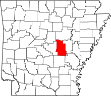 | |
| Towns | ||
| CDP | ||
| Townships |
| |
| Unincorporated communities | ||
| Footnotes | ‡This populated place also has portions in an adjacent county or counties | |
This article is issued from Wikipedia - version of the 5/28/2016. The text is available under the Creative Commons Attribution/Share Alike but additional terms may apply for the media files.