Allport, Arkansas
| Allport, Arkansas | |
|---|---|
| Town | |
 Location in Lonoke County and the state of Arkansas | |
 Allport, Arkansas Location in the United States | |
| Coordinates: 34°32′22″N 91°47′6″W / 34.53944°N 91.78500°WCoordinates: 34°32′22″N 91°47′6″W / 34.53944°N 91.78500°W | |
| Country | United States |
| State | Arkansas |
| County | Lonoke |
| Area | |
| • Total | 0.2 sq mi (0.5 km2) |
| • Land | 0.2 sq mi (0.5 km2) |
| • Water | 0 sq mi (0 km2) |
| Elevation | 203 ft (62 m) |
| Population (2000) | |
| • Total | 127 |
| • Density | 635/sq mi (254/km2) |
| Time zone | Central (CST) (UTC-6) |
| • Summer (DST) | CDT (UTC-5) |
| ZIP code | 72046 |
| Area code(s) | 501 |
| FIPS code | 05-00940 |
| GNIS feature ID | 0045838 |
Allport is a town in Lonoke County, Arkansas, United States. Although a black enclave in the largely-white Lonoke County since the 1870s, the town did not incorporate until 1967 in order to receive funding for municipal services. Located within Central Arkansas along Highway 165, the community's economy is strongly tied to agriculture. The population was 115 at the 2010 Census.
History
Allport was incorporated in 1967 and its first Mayor was an African-American man and World War II veteran named Johnny E. Gay. Leading the movement to incorporate, he made several needed improvements to the town upon his election. The Allport community set aside a special day of celebration named Johnny E. Gay Day.
Geography
Allport is located at 34°32′22″N 91°47′6″W / 34.53944°N 91.78500°W (34.539548, -91.784977).[1]
According to the United States Census Bureau, the town has a total area of 0.5 km² (0.2 mi²), all land.
Demographics
| Historical population | |||
|---|---|---|---|
| Census | Pop. | %± | |
| 1970 | 307 | — | |
| 1980 | 295 | −3.9% | |
| 1990 | 188 | −36.3% | |
| 2000 | 127 | −32.4% | |
| 2010 | 115 | −9.4% | |
| Est. 2015 | 114 | [2] | −0.9% |
2015 Estimate[4] | |||
As of the census[5] of 2000, there were 127 people, 44 households, and 30 families residing in the town. The population density was 272.4/km² (710.1/mi²). There were 59 housing units at an average density of 126.6/km² (329.9/mi²). The racial makeup of the town was 5.51% White and 94.49% Black or African American.
There were 44 households out of which 18.2% had children under the age of 18 living with them, 25.0% were married couples living together, 29.5% had a female householder with no husband present, and 31.8% were non-families. 31.8% of all households were made up of individuals and 15.9% had someone living alone who was 65 years of age or older. The average household size was 2.89 and the average family size was 3.77.
In the town the population was spread out with 26.8% under the age of 18, 9.4% from 18 to 24, 26.0% from 25 to 44, 23.6% from 45 to 64, and 14.2% who were 65 years of age or older. The median age was 34 years. For every 100 females there were 92.4 males. For every 100 females age 18 and over, there were 89.8 males.
The median income for a household in the town was $17,500, and the median income for a family was $18,333. Males had a median income of $23,125 versus $0 for females. The per capita income for the town was $18,685. There were 35.7% of families and 32.5% of the population living below the poverty line, including 52.4% of under eighteens and 48.4% of those over 64.
See also
-
 Arkansas portal
References
- ↑ "US Gazetteer files: 2010, 2000, and 1990". United States Census Bureau. 2011-02-12. Retrieved 2011-04-23.
- ↑ "Annual Estimates of the Resident Population for Incorporated Places: April 1, 2010 to July 1, 2015". Retrieved July 2, 2016.
- ↑ "Census of Population and Housing". Census.gov. Archived from the original on May 11, 2015. Retrieved June 4, 2015.
- ↑ "Annual Estimates of the Resident Population for Incorporated Places: April 1, 2010 to July 1, 2015". Retrieved June 2, 2016.
- ↑ "American FactFinder". United States Census Bureau. Archived from the original on 2013-09-11. Retrieved 2008-01-31.
Municipalities and communities of Lonoke County, Arkansas, United States | ||
|---|---|---|
| Cities | 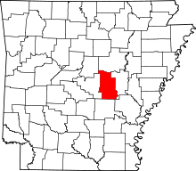 | |
| Towns | ||
| CDP | ||
| Townships |
| |
| Unincorporated communities | ||
| Footnotes | ‡This populated place also has portions in an adjacent county or counties | |