South Barrington, Illinois
| South Barrington, Illinois | |
|---|---|
| Village | |
| Village of South Barrington | |
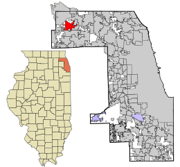 Location in Cook County and the state of Illinois. | |
.svg.png) Location of Illinois in the United States | |
| Coordinates: 42°5′3″N 88°9′17″W / 42.08417°N 88.15472°WCoordinates: 42°5′3″N 88°9′17″W / 42.08417°N 88.15472°W | |
| Country |
|
| State | Illinois |
| County | Cook |
| Township | Barrington |
| Incorporated | 1959 |
| Government | |
| • Type | President-trustee |
| • President | Alexander Lynn |
| Area | |
| • Total | 7.62 sq mi (19.7 km2) |
| • Land | 7.34 sq mi (19.0 km2) |
| • Water | 0.28 sq mi (0.7 km2) 3.67% |
| Population (2010) | |
| • Total | 4,565 |
| • Density | 621.9/sq mi (240.1/km2) |
| Up 21.4% from 2000 | |
| Standard of living (2007-11) | |
| • Per capita income | $70,004 |
| • Median home value | $841,900 |
| ZIP code(s) | 60010 |
| Area code(s) | 847 & 224 |
| Geocode | 70,564 |
| Website |
www |
| Demographics (2010)[1] | |||
|---|---|---|---|
| White | Black | Asian | |
| 69.6% | 0.7% | 26.6% | |
| Islander | Native | Other | Hispanic (any race) |
| 0.00% | 0.2% | 2.9% | 2.6% |
South Barrington is a village in Cook County, Illinois, United States, south of Barrington. The population was 4,565 at the 2010 census.[1] South Barrington is a wealthy suburb of Chicago and home to the famous megachurch Willow Creek Community Church. The Arboretum of South Barrington is a lifestyle center (shopping center) located within the village limits.
Geography
South Barrington is located at 42°5′3″N 88°9′17″W / 42.08417°N 88.15472°W (42.084226, -88.15478).[2]
According to the 2010 census, South Barrington has a total area of 7.619 square miles (19.73 km2), of which 7.34 square miles (19.01 km2) (or 96.34%) is land and 0.279 square miles (0.72 km2) (or 3.66%) is water.[3]
Demographics
| Historical population | |||
|---|---|---|---|
| Census | Pop. | %± | |
| 1960 | 473 | — | |
| 1970 | 348 | −26.4% | |
| 1980 | 1,168 | 235.6% | |
| 1990 | 2,937 | 151.5% | |
| 2000 | 3,760 | 28.0% | |
| 2010 | 4,565 | 21.4% | |
| Est. 2015 | 4,892 | [4] | 7.2% |
As of the census[6] of 2000, there were 3,760 people, 1,147 households, and 1,060 families residing in the village. The population density was 573.6 people per square mile (221.3/km²). There were 1,172 housing units at an average density of 178.8 per square mile (69.0/km²). The racial makeup of the village was 69.6% White, 0.88% African American, 0.05% Native American, 26.6% Asian, 0.03% Pacific Islander, 0.53% from other races, and 1.78% from two or more races. Hispanic or Latino of any race were 0.84% of the population. As of 2011 South Barrington is the Chicago suburb with the highest percentage of Asian people.[7]
There were 1,147 households out of which 47.7% had children under the age of 18 living with them, 86.1% were married couples living together, 4.1% had a female householder with no husband present, and 7.5% were non-families. 5.8% of all households were made up of individuals and 1.7% had someone living alone who was 65 years of age or older. The average household size was 3.28 and the average family size was 3.41.
In the village the population was spread out with 29.8% under the age of 18, 7.0% from 18 to 24, 20.3% from 25 to 44, 36.0% from 45 to 64, and 6.8% who were 65 years of age or older. The median age was 42 years. For every 100 females there were 97.9 males. For every 100 females age 18 and over, there were 98.5 males.
The median income for a household in the village was $170,755, and the median income for a family was $174,318. The per capita income for the village was $76,078. About 1.4% of families and 2.6% of the population were below the poverty line, including 4.5% of those under age 18 and 0.5% of those age 65 or over.
Notable people
- Craig Anderson, goaltender for the Colorado Avalanche and Ottawa Senators
- Mike Magee, forward with the Chicago Fire
- Walter Payton, Hall of Fame running back with the Chicago Bears
- Mike Singletary, Hall of Fame linebacker and coach with several NFL teams
- Paul Bragiel, Colombian National Team XC Skier, Venture Capitalist
References
- 1 2 "Profile of General Population and Housing Characteristics: 2010 Demographic Profile Data (DP-1): South Barrington village, Illinois". U.S. Census Bureau, American Factfinder. Retrieved March 20, 2013.
- ↑ "US Gazetteer files: 2010, 2000, and 1990". United States Census Bureau. 2011-02-12. Retrieved 2011-04-23.
- ↑ "G001 - Geographic Identifiers - 2010 Census Summary File 1". United States Census Bureau. Retrieved 2015-12-25.
- ↑ "Annual Estimates of the Resident Population for Incorporated Places: April 1, 2010 to July 1, 2015". Retrieved July 2, 2016.
- ↑ "Census of Population and Housing". Census.gov. Retrieved June 4, 2015.
- ↑ "American FactFinder". United States Census Bureau. Retrieved 2008-01-31.
- ↑ Selvam, Ashok. "Asian population booming in suburbs." Daily Herald (Arlington Heights, Illinois). March 6, 2011. Retrieved on June 19, 2013.
External links
- Village of South Barrington official website
- South Barrington, IL, Encyclopedia of Chicago
- Barrington Area Library
- South Barrington, Illinois at DMOZ
| Major city |  | |
|---|---|---|
| Cities (over 30,000 in 2010) | ||
| Towns and villages (over 30,000 in 2010) |
| |
| Counties | ||
| Regions | ||
| Sub-regions | ||