Shepeau Stow, Lincolnshire
| Shepeau Stow | |
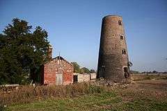 Tower mill, Shepeau Stow |
|
 Shepeau Stow |
|
| OS grid reference | TF306122 |
|---|---|
| – London | 85 mi (137 km) S |
| District | South Holland |
| Shire county | Lincolnshire |
| Region | East Midlands |
| Country | England |
| Sovereign state | United Kingdom |
| Post town | Spalding |
| Postcode district | PE12 |
| Police | Lincolnshire |
| Fire | Lincolnshire |
| Ambulance | East Midlands |
| EU Parliament | East Midlands |
| UK Parliament | South Holland and the Deepings |
|
|
Coordinates: 52°41′32″N 0°04′05″W / 52.692356°N 0.067946527°W
Shepeau Stow is a hamlet in the South Holland district of Lincolnshire, England. It is situated at the north-east edge of Whaplode civil parish, where it adjoins Crowland civil parish, and on the B1166 Hull's Drove road. Shepeau Stow is 7 miles (11 km) south-east from Spalding and 4 miles (6 km) east from Crowland.
The hamlet's school is Shepeau Stow Primary School on Dowsdale Bank.[1] In the 2012 latest Ofsted report, the school received an overall Grade 2 (Good), quality rating.[2]
History
The B1166 road from Shepeau Stow to Holbeach Drove to the east is the line of a 1241 fen drainage bank, the third of three constructed between Whaplode Drove to the north and Shepeau Stow. The resulting fen-drained common land was enclosed in 1819 under Enclosure Act.[3]

In 19th-century directories the hamlet was named 'Shephaystow' and 'Shephay Stowe'. In 1855 there existed a mill with miller, and the Red Last public house. By 1872 the mill housed a corn miller who was also a baker. There was a pub called the Mill Inn run by a victualler who was also a brewer and shopkeeper at the same premises. There was a blacksmith, and a shoemaker who also ran a beerhouse. 1885 listings included a publican at the Red Last Inn, a coal dealer, a farmer, a blacksmith, and a wind miller. By 1933 listed were two farmers, a saddler, a carpenter, and the publican at the Red Last. Within the hamlet was a Methodist chapel with seating for 300, while the surrounding area produced potatoes, wheat and other cereals, and "large quantities of geese fatted for the London and other markets."[4][5][6][7] The Red Last Inn was a brewery pub, extant in 1949, but now converted to a private dwelling.[8]
At the east of the hamlet on Drove Road are the Grade II listed late 18th-century remains of the tower mill.[9] The mill was working with four sails until the 1920s, but by the middle of the 1930s it had lost its roof and become a ruin.[10]
In 2015 late 19th-century 'T' plan barn buildings of hand made brick, "good examples of local rural vernacular architecture," were the subject of an historic building survey before a proposed redevelopment at Carter's Farm on Oxcroft Bank. The survey showed various stages of original building, which included a hay loft and wood partitions, with stable block and cattle shed with hayracks and feed troughs.[11]
References
- ↑ "Shepeau Stow Primary School", Directgov. Retrieved 21 March 2016
- ↑ "Sturton by Stow Primary School", Ofsted, Retrieved 21 March 2016
- ↑ "A Brief History of Whaplode Drove", Whaplode Parish Council. Retrieved 17 March 2016
- ↑ Kelly's Directory of Lincolnshire 1855, p.249
- ↑ White’s History, Gazeteer and Directory of Lincolnshire 1872, p.786
- ↑ Kelly's Directory of Lincolnshire with the port of Hull 1885, p.705
- ↑ Kelly's Directory of Lincolnshire 1933, pp.603,604
- ↑ "The Red Last Inn Shepeau Stow", Chain Bridge Forge Museum. Retrieved 17 March 2016
- ↑ Historic England. "Windmill, Whaplode (1147706)". National Heritage List for England. Retrieved 17 March 2016.
- ↑ "Shepeau Stow Mill, Whaplode", Lincolnshire County Council. Retrieved 17 March 2016
- ↑ "Farm Buildings at Carter's Farm, Oxcroft Bank, Shepeau Stow", Lincs to the Past, Reference: MLI86934. Retrieved 17 March 2016
External links
 Media related to Shepeau Stow at Wikimedia Commons
- Shepeau Stow Primary School. Retrieved 17 March 2016
- "Shepeau Stow", Ordnance Survey map of extent of hamlet; South East Lincolnshire Joint Strategic Planning Committee. Retrieved 17 March 2016
England Portal | |
| Unitary authorities | |
| Boroughs or districts | |
| Major settlements |
|
| Topics | |