San Luis Pass

San Luis Pass is a strait of water at the south-western end of Galveston Island off the shores of the U.S. state of Texas. It connects the sheltered waters of West Bay to the open Gulf of Mexico. Swimmers and fishermen have been killed in the Pass' treacherous waters, largely due to murky water, uncharted drop-offs, and fast moving currents. The San Luis Pass-Vacek Toll Bridge spans San Luis Pass into Brazoria County.
Characteristics
Tide levels can vary by almost 2 feet in height, although the tidal effects seem more pronounced along straits than other barrier island zones. Water current dangers are prominent up to about one mile away from the pass along either island. A high amount of drownings occur in the vicinity of the San Luis Pass compared to other areas off of nearby beaches.[1] Until June 2013, about 10 people drowned near San Luis pass on the Galveston side since 2001,[1] and of those about 6 drowned there since 2007.[2] The depth of the pass varies to up to 40 feet deep.[3]
Tides cause daily variations in topography, and occasionally, storms more drastically change the topography of the pass.
Fishing and recreation
Pier fishing on the San Luis Pass Pier was a favorite for visitors and locals alike for many years, however the beach and pier were wiped out during Hurricane Ike in 2008, and it was not rebuilt. The pass is also home to bank fishermen who often travel many miles to take advantage of the excellent redfish population from June thru October.
Overnight camping, while once allowed, is prohibited on the Galveston side of the pass. The San Luis Pass Camp Ground and county park, on the Brazoria County side, is the only accessible place now.[4] At least from the Galveston Island side, entering the water is prohibited, because of safety hazards.[1][5]
Hurricane Ike in September 2008, forever changed the topography of the beach. What was once a driveway and public beach access is now part of the Gulf of Mexico. The land where the bait house of the pier once stood is now permanently submerged.
San Luis Pass on the Galveston side is a place for bird watching.[6]
San Luis Pass-Vacek Toll Bridge
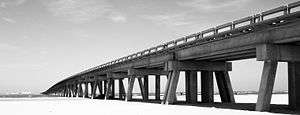
The "San Luis Pass-Vacek Toll Bridge" or San Luis Pass Bridge was built shortly before 1970.[7] It is operated by Galveston County, Road District 1.[8] This bridge has 2 lanes, is 1.3 miles,[8] and has a toll fee of $2. Surfside Beach is the closest city on the other side of Galveston along Brazoria County Road 257.
San Luis
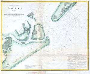
Across the strait from Galveston, San Luis was an island until 1885, when the strait Little Pass closed.[9] It is now a part of Follet's Island that was once called the Velasco Peninsula.[10]
San Luis, Texas was an abandoned establishment that once had a population of 2,000 after 1836.[9] As of 1989, about 20 people inhabited this area.[9]
The San Luis Pass County Park is on this location.
References
- 1 2 3 "Learn Galveston County's deadliest and safest areas to swim". The Daily News Galveston County. June 14, 2013. Retrieved 2013-06-14.
- ↑ "Galveston Island drownings since 2007". The Daily News Galveston County. June 14, 2013. Retrieved 2013-06-14.
- ↑ Leatherwood, Art. "SAN LUIS PASS". Handbook of Texas Online. Texas State Historical Association. Retrieved 2013-06-15.
- ↑ "San Luis Pass County Park". Brazoria County. Retrieved 2013-06-10.
- ↑ "San Luis Pass and West End Beaches". Galveston Island Beach Patrol. Texas Beach Safety.org. Retrieved 2013-06-11.
- ↑ "Great Birding from and on Galveston Island, Texas". Galveston.com. Retrieved 2013-06-11.
- ↑ Benton; Snell. "Coastal Processes: GALVESTON: AN AERIAL PHOTOGRAPHIC ANALYSIS OF A POPULATED BARRIER ISLAND" (PDF). National Science Foundation; University of Florida. Retrieved 2013-06-11.
- 1 2 "Office of Highway Policy Information". FHWA Dot. Retrieved 2013-06-16.
- 1 2 3 Jones, Marie Beth. "San Luis, TX". Handbook of Texas Online. Texas State Historical Association. Retrieved 2013-06-10.
- ↑ "FOLLET'S ISLAND". Handbook of Texas Online. Texas State Historical Association. Retrieved June 9, 2013.
External links
| Wikivoyage has a travel guide for Galveston. |
- A Sedimentologic Description of a Microtidal, Flood-Tidal Delta, San Luis Pass, Texas
- Houston Chronicle news story of drowning
- Dallas swimmer missing at San Luis Pass

Coordinates: 29°04′57″N 95°07′18″W / 29.08250°N 95.12167°W