Galveston Seawall
The Galveston Seawall is a seawall in Galveston, Texas, USA that was built after the Galveston Hurricane of 1900 for protection from future hurricanes. Construction began in September, 1902, and the initial segment was completed on July 29, 1904. From 1904 to 1963, the seawall was extended from 3.3 miles (5.3 km) to over 10 miles (16 km) long.[1]
Reporting in the aftermath of the 1983 Hurricane Alicia, the Corps of Engineers estimated that $100 million in damage was avoided because of the seawall.[2] On September 13, 2008 Hurricane Ike's storm surge and large waves over-topped the seawall.[3] As a result, a commission was established by the Texas Governor following the hurricane to investigate preparing for and mitigating future disasters.[4]
A proposal has been put forth to build an "Ike Dike," a massive levee system which would protect the Galveston Bay, and the important industrial facilities which line the coast and the ship channel, from a future, potentially more destructive storm. The proposal has gained widespread support from a variety of business interests. As of 2009 it is currently only at the conceptual stage. Further proposals for a layered network of smaller, local levees and natural protections have been put forward by the SSPEED Center at Rice University and the University of Houston. These proposals include a surge gate at the mouth of the Houston Ship Channel connecting adjacent high ground near the Hartman Bridge, and hard protections for the west shore of Galveston Bay and around the densely developed east end of Galveston Island. Also included is the proposed lower coastal Lone Star Coastal National Recreation Area.
Texas F.M. 3005 is known as Seawall Boulevard where it runs along the seawall. The sidewalk adjacent to Seawall Boulevard on top of the seawall is claimed to be the longest continuous sidewalk in the world at 10.3 miles (16.6 km) long.[5]
The seawall is 10 miles (16 km) long. It is approximately 17 feet (5.2 m) high, and 16 feet (4.9 m) thick at its base. The seawall was listed in the National Register of Historic Places in 1977 and designated a National Civil Engineering Landmark by the American Society of Civil Engineers (ASCE) in 2001.[6]
Many miles of the seawall are painted with murals called "wall art". These huge murals are painted by children and depict underwater life. The art is meant to make the seawall more interesting to visitors.
Gallery
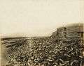 Damage to Seawall after 1915 Hurricane.
 Galveston Seawall paintings.
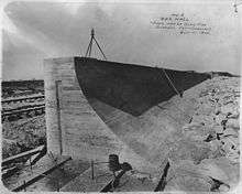
 Sea Wall and beach, Galveston, Texas (postcard, circa 1907).
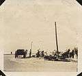 Workers repairing Seawall Boulevard after 1915 Galveston Hurricane.
References
- ↑ SEAWALL Accessed 2008-09-17.
- ↑ USA Today. 1999-08-30 http://www.usatoday.com/weather/huricane/history/walicia.htm. Retrieved 2010-05-03. Missing or empty
|title=(help) - ↑ Casselman, Ben (2008-09-12). "As Waters Rise, Many Decline To Leave Galveston Island". The Wall Street Journal. Retrieved 2008-09-13.
By 4 p.m., waves were overtopping the city's 17-foot-tall seawall and parts of...island were unreachable even by rescue crews.
- ↑ Casselman, Ben (4 June 2009). "Planning the 'Ike Dike' Defense". Wall Street Journal.
- ↑ Galveston, Texas Outdoor Recreation & Nature Accessed 2012-03-15.
- ↑ Moran, Kevin (9 September 1990). "City has raised storm preparedness to a fine art". Houston Chronicle.
Further reading
- Austin, A. (March 1905). "Galveston, The City Reclaimed: Marvelous Recuperation of a Town Wiped Out Four Years Ago". Pearson's Magazine. XIII (3): 211–219. Retrieved 2009-07-15.
- Gillette, Halbert Powers; Hill, Charles Shattuck (1908). Concrete Construction: Methods and Cost. New York: The Myron C. Clark Publishing Co. pp. 268–269. Retrieved 2009-07-15. (Diagrams of the movable concrete mixer plant used for construction of the seawall)
- Putnam, Frank (June 1907). "Galveston, An Epitome Of American Pluck". The New England Magazine. XXXVI (4): 387–403. Retrieved 2009-07-15.
- Slosson, W. B. (June 16, 1904). "The New Galveston". The Independent. LVI (2898): 1382–1387. Retrieved 2009-07-15.
- Williams, Clement Clarence (1922). The Design Of Masonry Structures And Foundations. New York: McGraw-Hill Book Company. p. 248. Retrieved 2009-07-15. (Diagram and description of the geometry of the seawall to dissipate wave energy)
- Shaw, Albert (November 1903). "Galveston's Great Sea Wall". The American Monthly Review of Reviews. XXVIII: 574–576. 5. Retrieved 2009-07-15.
- "Raising the Grade of Galveston". Locomotive Firemen's Magazine. XXXVI (5): 643–647. May 1904. Retrieved 2009-07-15.
External links
| Wikimedia Commons has media related to Galveston Seawall. |
Coordinates: 29°18′09″N 94°46′28″W / 29.30250°N 94.77444°W