Richland Township, Fulton County, Indiana
| Richland Township | |
|---|---|
| Township | |
|
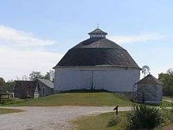
The Bert Leedy Round Barn, a historic site in the township | |
 Location of Richland Township in Fulton County | |
| Coordinates: 41°08′06″N 86°16′13″W / 41.13500°N 86.27028°WCoordinates: 41°08′06″N 86°16′13″W / 41.13500°N 86.27028°W | |
| Country | United States |
| State | Indiana |
| County | Fulton |
| Government | |
| • Type | Indiana township |
| Area | |
| • Total | 37.6 sq mi (97 km2) |
| • Land | 37.48 sq mi (97.1 km2) |
| • Water | 0.12 sq mi (0.3 km2) |
| Elevation[1] | 843 ft (257 m) |
| Population (2010) | |
| • Total | 1,181 |
| • Density | 31.5/sq mi (12.2/km2) |
| FIPS code | 18-64044[2] |
| GNIS feature ID | 453792 |
Richland Township is one of eight townships in Fulton County, Indiana. As of the 2010 census, its population was 1,181 and it contained 502 housing units.[3]
History
The Bert Leedy Round Barn was listed on the National Register of Historic Places in 1993.[4]
Geography
According to the 2010 census, the township has a total area of 37.6 square miles (97 km2), of which 37.48 square miles (97.1 km2) (or 99.68%) is land and 0.12 square miles (0.31 km2) (or 0.32%) is water.[3]
Unincorporated towns
Adjacent townships
- Green Township, Marshall County (north)
- Walnut Township, Marshall County (northeast)
- Newcastle Township (east)
- Rochester Township (south)
- Aubbeenaubbee Township (west)
- Union Township, Marshall County (northwest)
Major highways
Cemeteries
The township contains one cemetery, Sand Hill.
References
- ↑ "US Board on Geographic Names". United States Geological Survey. 2007-10-25. Retrieved 2008-01-31.
- ↑ "American FactFinder". United States Census Bureau. Archived from the original on September 11, 2013. Retrieved 2008-01-31.
- 1 2 "Population, Housing Units, Area, and Density: 2010 - County -- County Subdivision and Place -- 2010 Census Summary File 1". United States Census. Retrieved 2013-05-10.
- ↑ National Park Service (2010-07-09). "National Register Information System". National Register of Historic Places. National Park Service.
External links
Municipalities and communities of Fulton County, Indiana, United States | ||
|---|---|---|
| City | ||
| Towns | ||
| Townships | ||
| Unincorporated communities | ||
| Footnotes | ‡This populated place also has portions in an adjacent county or counties | |
This article is issued from Wikipedia - version of the 9/10/2016. The text is available under the Creative Commons Attribution/Share Alike but additional terms may apply for the media files.