Rayners Lane
| Rayners Lane | |
 Shops on the junction of Rayners Lane and Village Way |
|
 Rayners Lane |
|
| Population | 11,124 (2011 Census. Ward)[1] |
|---|---|
| OS grid reference | TQ128873 |
| London borough | Harrow |
| Ceremonial county | Greater London |
| Region | London |
| Country | England |
| Sovereign state | United Kingdom |
| Post town | SOUTH HARROW PINNER |
| Postcode district | HA2 |
| Postcode district | HA5 |
| Dialling code | 020 |
| Police | Metropolitan |
| Fire | London |
| Ambulance | London |
| EU Parliament | London |
| UK Parliament | Harrow West |
| London Assembly | Brent and Harrow |
Coordinates: 51°34′25″N 0°22′25″W / 51.5737°N 0.3735°W
Rayners Lane is a suburban district in the London Borough of Harrow in Northwest London between Pinner and West Harrow.[2] It takes its name from a road in the area, also called Rayners Lane (formerly also spelt Rayner's Lane) which runs from Marsh Road in Pinner to Eastcote Lane in Eastcote.[3]
History
During the Middle Ages the Rayners Lane road was used when transporting grain to the mill on Pinner Green. The road was originally called Bourne Lane as it crossed several streams including the Yeading Brook. During the first half of the nineteenth century the area was in the hands of the Rayner family, who owned a farm. The area was drastically built up between 1929 and 1938 by Harrow's biggest interwar housebuilder T.F. Nash, who created a shopping parade on Alexandra Avenue. The area to the north of the tube station was originally named Harrow Garden Village by its developer, and was one of Metro-land's flagship points.

Former Cunard officer Commodore Harry Grattidge, one of the last captains of the RMS Queen Elizabeth, lived at number 33 High Worple, Rayners Lane until his death in the 1970s.
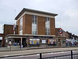
The area is most widely known as the location of Rayners Lane tube station, first built in 1906, and most of the settlement is built around the tube station. The station links both the Metropolitan and Piccadilly lines and therefore has good connections with the rest of London.
The other principal point of architectural interest is the former cinema, an Art Deco building featuring a curved projection on the front somewhat resembling an elephant's trunk. This is a listed building. It is currently occupied by the Zoroastrian Trust Funds of Europe, and is used as a Zoroastrian centre - the only official temple of its type in the UK.
Despite being a relatively small area, it boasts many retail chains, mainly due to the presence of the tube station, including Sainsbury's Local, Tesco Express, Pizza Hut, Subway, Costa Coffee and KFC. Also located in Rayners Lane is the head office of the bookmaking and e-gaming company Ladbrokes. The area has two banks, NatWest and Santander UK.
Demography
The largest ethnic group in Rayners Lane ward in the 2011 census was Indian (28%), followed by White British (27%) and other Asian (21%).[4]
Sport
The area also has its own football club, Rayners Lane F.C. who currently play in the Hellenic Football League.
It also has a sports club called Harrow Town Sports club which has been there since the 1890s. It is the home of the Harrow Town Cricket Club, the Venceremos FC and the HT Tennis Club.
Transport
Tube
Bus routes
- 398
- H9
- H10
- H12
- 618
- 619
Nearby places
References
- ↑ "Harrow Ward population 2011". Neighbourhood Statistics. Office for National Statistics. Retrieved 23 October 2016.
- ↑ "Rayners Lane". hidden-london.co.uk. Retrieved 2007-07-18.
- ↑ Ayto, John; Crofton, Ian (2005). Brewer's Britain and Ireland. Weidenfeld and Nicholson. p. 913. Consulted 12 August 2016.
- ↑ http://www.ukcensusdata.com/rayners-lane-e05000300
Sources
| Wikimedia Commons has media related to Rayners Lane. |
| Districts | 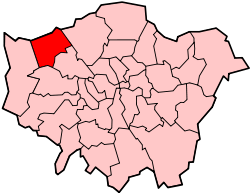 | |
|---|---|---|
| Attractions | ||
| Parks and open spaces |
| |
| Constituencies | ||
| Tube and rail stations | ||
| Other topics | ||