Princess Anne, Maryland
| Princess Anne, Maryland | |
|---|---|
| Town | |
 Location of Princess Anne, Maryland | |
| Coordinates: 38°12′35″N 75°41′42″W / 38.20972°N 75.69500°WCoordinates: 38°12′35″N 75°41′42″W / 38.20972°N 75.69500°W | |
| Country | United States |
| State | Maryland |
| County | Somerset |
| Incorporated | 1733 |
| Government | |
| • Town Manager | Winslow "Jay" Parker |
| Area[1] | |
| • Total | 1.69 sq mi (4.38 km2) |
| • Land | 1.67 sq mi (4.33 km2) |
| • Water | 0.02 sq mi (0.05 km2) |
| Elevation | 18 ft (5 m) |
| Population (2010)[2] | |
| • Total | 3,269 |
| • Estimate (2012[3]) | 3,308 |
| • Density | 1,970.1/sq mi (760.7/km2) |
| Time zone | EST (UTC-5) |
| • Summer (DST) | EDT (UTC-4) |
| ZIP code | 21853 |
| Area code(s) | 410 |
| FIPS code | 24-64000 |
| GNIS feature ID | 0591074 |
| Website | http://www.townofprincessanne.com/ |
Princess Anne is a town in Somerset County, Maryland, United States, and also serves as its county seat.[4] The population was 3,290 at the 2010 census.
Princess Anne is included in the Salisbury, Maryland-Delaware Metropolitan Statistical Area.
The town is notable as the location of the University of Maryland Eastern Shore and the home of the Teackle Mansion.
History
With a population just under 4,000 people, this hamlet at the head of the Manokin River was named for Princess Anne of Great Britain, daughter of King George II. It was established in 1733 and serves as the county seat for Somerset County (the southernmost county in Maryland).
In the mid-18th century, Princess Anne gained considerable importance as a market center because of the river trade. This was later augmented by the southward extension of the Eastern Shore Railroad on Maryland's Eastern Shore. At that time, the Manokin River was navigable as far as the bridge at Princess Anne.
Much of the town's architectural heritage from those days has been preserved. About 150 acres (0.6 km²) of the old town, containing about 300 structures, is entered on the National Register of Historic Places as the Princess Anne Historic District.
In addition to the Princess Anne Historic District, the Adams Farm, Beckford, Beverly, Catalpa Farm, Glebe House, Harrington, Manokin Historic District, Manokin Presbyterian Church, Mt. Zion Memorial Church, Dr. William B. Pritchard House, Somerset Academy Archaeological Site, Teackle Mansion, University of Maryland Eastern Shore, Waddy House, Waterloo, and White Hall are listed on the National Register of Historic Places.[5]
Princess Anne has the ignoble distinction of being the site of the last lynching in Maryland history. In 1933, a black man named George Armwood was accused of assaulting an elderly white woman. He was removed from the Princess Anne jail by a white mob, dragged around town by a truck, and eventually hanged. After his death, the rope that formed the noose was cut up and distributed as a souvenir.[6]
Geography
Princess Anne is located at 38°12′N 75°42′W / 38.200°N 75.700°W (38.204, -75.695).[7]
According to the United States Census Bureau, the town has a total area of 1.69 square miles (4.38 km2), of which, 1.67 square miles (4.33 km2) is land and 0.02 square miles (0.05 km2) is water.[1]
Climate
The climate in this area is characterized by hot, humid summers and generally mild to cool winters. According to the Köppen Climate Classification system, Princess Anne has a humid subtropical climate, abbreviated "Cfa" on climate maps.[8]
Demographics
| Historical population | |||
|---|---|---|---|
| Census | Pop. | %± | |
| 1870 | 805 | — | |
| 1880 | 751 | −6.7% | |
| 1890 | 865 | 15.2% | |
| 1900 | 854 | −1.3% | |
| 1910 | 1,006 | 17.8% | |
| 1920 | 968 | −3.8% | |
| 1930 | 975 | 0.7% | |
| 1940 | 942 | −3.4% | |
| 1950 | 1,407 | 49.4% | |
| 1960 | 1,351 | −4.0% | |
| 1970 | 975 | −27.8% | |
| 1980 | 1,499 | 53.7% | |
| 1990 | 1,666 | 11.1% | |
| 2000 | 2,313 | 38.8% | |
| 2010 | 3,290 | 42.2% | |
| Est. 2015 | 3,303 | [9] | 0.4% |
2010 census
As of the census[2] of 2010, there were 3,290 people, 1,276 households, and 652 families residing in the town. The population density was 1,970.1 inhabitants per square mile (760.7/km2). There were 1,500 housing units at an average density of 898.2 per square mile (346.8/km2). The racial makeup of the town was 27.1% White, 68.4% African American, 0.2% Native American, 1.4% Asian, 0.6% from other races, and 2.4% from two or more races. Hispanic or Latino of any race were 2.9% of the population.
There were 1,276 households of which 30.5% had children under the age of 18 living with them, 25.3% were married couples living together, 22.1% had a female householder with no husband present, 3.7% had a male householder with no wife present, and 48.9% were non-families. 37.1% of all households were made up of individuals and 6.6% had someone living alone who was 65 years of age or older. The average household size was 2.49 and the average family size was 3.04.
The median age in the town was 24.7 years. 21.6% of residents were under the age of 18; 29% were between the ages of 18 and 24; 23.6% were from 25 to 44; 17.7% were from 45 to 64; and 8.1% were 65 years of age or older. The gender makeup of the town was 40.1% male and 59.9% female.
2000 census
As of the census[11] of 2000, there were 2,313 people, 992 households, and 498 families residing in the town. The population density was 1,843.2 people per square mile (714.4/km²). There were 1,117 housing units at an average density of 890.1 per square mile (345.0/km²). The racial makeup of the town was 34.59% White, 62.86% African American, 0.56% Native American, 0.78% Asian, 0.04% Pacific Islander, 0.48% from other races, and 0.69% from two or more races. Hispanic or Latino of any race were 1.69% of the population.
There were 992 households out of which 26.4% had children under the age of 18 living with them, 25.4% were married couples living together, 21.3% had a female householder with no husband present, and 49.7% were non-families. 38.4% of all households were made up of individuals and 12.1% had someone living alone who was 65 years of age or older. The average household size was 2.31 and the average family size was 3.14.
In the town the population was spread out with 26.2% under the age of 18, 20.2% from 18 to 24, 25.7% from 25 to 44, 17.0% from 45 to 64, and 10.9% who were 65 years of age or older. The median age was 28 years. For every 100 females there were 84.7 males. For every 100 females age 18 and over, there were 77.7 males.
The median income for a household in the town was $20,066, and the median income for a family was $26,351. Males had a median income of $19,492 versus $22,857 for females. The per capita income for the town was $10,944. About 30.1% of families and 39.8% of the population were below the poverty line, including 53.8% of those under age 18 and 21.0% of those age 65 or over.
Colleges and universities
Notable people
- George Armwood, lynched in Princess Anne, Maryland on October 18, 1933.[12]
- Samuel Chase, signer of the Declaration of Independence and Supreme Court associate justice
- Charles Chaille-Long Soldier and explorer
- Phillips Lee Goldsborough, Governor of Maryland and U.S. senator from Maryland
References
- 1 2 "US Gazetteer files 2010". United States Census Bureau. Retrieved 2013-01-25.
- 1 2 "American FactFinder". United States Census Bureau. Retrieved 2013-01-25.
- ↑ "Population Estimates". United States Census Bureau. Retrieved 2013-06-26.
- ↑ "Find a County". National Association of Counties. Retrieved 2011-06-07.
- ↑ National Park Service (2010-07-09). "National Register Information System". National Register of Historic Places. National Park Service.
- ↑ "Conspiracy of Silence in Md. Lynching Orgy". The Pittsburgh Courier. 28 October 1933.
- ↑ "US Gazetteer files: 2010, 2000, and 1990". United States Census Bureau. 2011-02-12. Retrieved 2011-04-23.
- ↑ Climate Summary for Princess Anne, Maryland
- ↑ "Annual Estimates of the Resident Population for Incorporated Places: April 1, 2010 to July 1, 2015". Retrieved July 2, 2016.
- ↑ "Census of Population and Housing". Census.gov. Retrieved June 4, 2015.
- ↑ "American FactFinder". United States Census Bureau. Retrieved 2008-01-31.
- ↑ "George Armwood (b. 1911 - d. 1933)". Biographical Series. Archives of Maryland. Retrieved 17 January 2015.
External links
 Media related to Princess Anne, Maryland at Wikimedia Commons
 Princess Anne travel guide from Wikivoyage
Municipalities and communities of Somerset County, Maryland, United States | ||
|---|---|---|
| City | 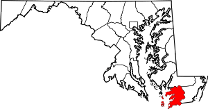 | |
| Town | ||
| CDPs | ||
| Other communities | ||
| Counties |  | |
|---|---|---|
| Principal city | ||
| Places 5k-20k | ||
| Places 1k-5k | ||