Pleasant Grove Township, Greenwood County, Kansas
| Pleasant Grove Township | |
|---|---|
| Township | |
 Location in Greenwood County | |
| Coordinates: 37°47′15″N 096°02′33″W / 37.78750°N 96.04250°WCoordinates: 37°47′15″N 096°02′33″W / 37.78750°N 96.04250°W | |
| Country | United States |
| State | Kansas |
| County | Greenwood |
| Area | |
| • Total | 59 sq mi (152.82 km2) |
| • Land | 58.07 sq mi (150.41 km2) |
| • Water | 0.93 sq mi (2.41 km2) 1.58% |
| Elevation | 1,007 ft (307 m) |
| Population (2000) | |
| • Total | 52 |
| • Density | 0.9/sq mi (0.3/km2) |
| GNIS feature ID | 0474662 |
Pleasant Grove Township is a township in Greenwood County, in the U.S. state of Kansas. As of the 2000 census, its population was 52.
Geography
Pleasant Grove Township covers an area of 59 square miles (150 km2) and contains no incorporated settlements. According to the United States Geological Survey (USGS), it contains two cemeteries: Neal and Rocky Ford.
The streams of Cedar Creek, Fancy Creek, Kuntz Branch, Tar Creek and Walnut Creek run through this township.
References
External links
Municipalities and communities of Greenwood County, Kansas, United States | ||
|---|---|---|
| Cities | 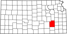 | |
| Unincorporated communities | ||
| Ghost towns | ||
| Townships | ||
This article is issued from Wikipedia - version of the 11/11/2013. The text is available under the Creative Commons Attribution/Share Alike but additional terms may apply for the media files.