Janesville Township, Greenwood County, Kansas
| Janesville Township | |
|---|---|
| Township | |
 Location in Greenwood County | |
| Coordinates: 37°59′05″N 096°11′46″W / 37.98472°N 96.19611°WCoordinates: 37°59′05″N 096°11′46″W / 37.98472°N 96.19611°W | |
| Country | United States |
| State | Kansas |
| County | Greenwood |
| Area | |
| • Total | 144.04 sq mi (373.07 km2) |
| • Land | 143.14 sq mi (370.74 km2) |
| • Water | 0.9 sq mi (2.33 km2) 0.62% |
| Elevation | 1,106 ft (337 m) |
| Population (2000) | |
| • Total | 548 |
| • Density | 3.8/sq mi (1.5/km2) |
| GNIS feature ID | 0474443 |
Janesville Township is a township in Greenwood County, Kansas, USA. As of the 2000 census, its population was 548.
Geography
Janesville Township covers an area of 144.04 square miles (373.1 km2) and contains one incorporated settlement, Hamilton. According to the USGS, it contains four cemeteries: Homer Creek, Ott, Prairie Chapel and Township.
The streams of Homer Creek, Indian Creek, Onion Creek, Slate Creek and Willow Creek run through this township.
Transportation
Janesville Township contains one airport or landing strip, King Ranch Airport.
References
External links
Municipalities and communities of Greenwood County, Kansas, United States | ||
|---|---|---|
| Cities | 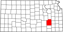 | |
| Unincorporated communities | ||
| Ghost towns | ||
| Townships | ||
This article is issued from Wikipedia - version of the 11/11/2013. The text is available under the Creative Commons Attribution/Share Alike but additional terms may apply for the media files.