Lamont, Kansas
| Lamont, Kansas | |
|---|---|
| Unincorporated community | |
 Lamont, Kansas  Lamont, Kansas Location within the state of Kansas | |
| Coordinates: 38°6′45″N 96°1′36″W / 38.11250°N 96.02667°WCoordinates: 38°6′45″N 96°1′36″W / 38.11250°N 96.02667°W | |
| Country | United States |
| State | Kansas |
| County | Greenwood |
| Time zone | Central (CST) (UTC-6) |
| • Summer (DST) | CDT (UTC-5) |
| ZIP codes | 66855 |
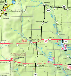
Map of Greenwood County from KDOT (map legend)
Lamont (also La Monts Mill) is an unincorporated community in northeastern Greenwood County, Kansas, United States. It lies along K-58 northeast of the city of Eureka, the county seat of Greenwood County.[1] Its elevation is 1,125 feet (343 m), and it is located at 38°6′45″N 96°1′36″W / 38.11250°N 96.02667°W (38.1125234, -96.0266589).[2] Although Lamont is unincorporated, it has a post office, with the ZIP code of 66855.[3] The post office at Lamont was established in February 1888.[4]
Lamont was laid out in about 1889.[5]
References
- ↑ Rand McNally. The Road Atlas '08. Chicago: Rand McNally, 2008, p. 41.
- ↑ Geographic Names Information System Feature Detail Report, Geographic Names Information System, 1978-10-13. Accessed 2008-04-28.
- ↑ Zip Code Lookup
- ↑ "Kansas Post Offices, 1828-1961 (archive)". Kansas Historical Society. Archived from the original on October 9, 2013. Retrieved 10 June 2014.
- ↑ Kansas State Historical Society (1916). Biennial Report of the Board of Directors of the Kansas State Historical Society. Kansas State Printing Plant. p. 199.
Municipalities and communities of Greenwood County, Kansas, United States | ||
|---|---|---|
| Cities | 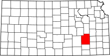 | |
| Unincorporated communities | ||
| Ghost towns | ||
| Townships | ||
This article is issued from Wikipedia - version of the 10/12/2016. The text is available under the Creative Commons Attribution/Share Alike but additional terms may apply for the media files.