Platô
.jpg)

Platô or the Plateau of Praia (Portuguese: planalto) is the historic center of the capital city of Praia in the island of Santiago, Cape Verde. It is the spot where it previous settlement was founded in the 16th century, later Praia de Santa Maria (commonly known as Gamboa today) was founded in 1615. The highest point is about 15 meters, the lowest point is the Atlantic and Praia Harbor. The plateau measures about 1.07 km from north to south and a bit east, exactly 1 kilometer at the top portion, its width ranges from 250 meters in the middle to 350 meters of the top part and up to 400 meters to the road, the neighborhood's length is about 500 meters, the northeastern part is 700 meters long and extends up to the stream and includes the tiny beach known is Praia Negra as its sands are black, furthermost about 900 meters. Its total area is about 60 to 70 hectares (75 hectares) up to the stream. The elevation varies, the lowest is at sea level, the elevation at the center which is at Albuquerque square is 31 meters, the highest point is 38 meters in the middle, 18 to 25 meters in the midwestern part, 20 to 30 meters in the eastern part, 7 meters at Várzea and 12 meters near Calabaceira.
Bordering neighbourhoods includes Gamboa (also known as Chã de Areias) to the south, Vàrzea to the southwest and west, Craveiro Lopes to the west, Achadinha de Baixo to the northwest, Fazenda to the north, Paiol and Lem Ferreira slightly to the northeast and Achada Grande-Porto da Praia to the northeast, the north and south boundaries are on streets, The eastern part is the bay with a road encircling it, the northeast starts the main road to the north of the island and the southwest the access to Ribeira Grande and Porto Mosquito. One of the eastern boundaries is within Ribeira da Trindade, 12 km in length where the source is in the northwest of the municipality with some streams starting in São Domingos municipality, its boundary with plato finishes at the boundary with Calabaceira.
History
Early in the 16th century, the low lying areas were forested with kapok trees, they were cut down to make room for farming and agriculture, the forest stretched up to Ribeira Grande. Later some portions of the forest were restored mainly with palm in the 18th century and the remainder restored with kapok trees and intermingled with buildings and landmarks built in the 1930s and the mid 20th century, a dense palm grove as they were in the mid-20th century no longer exist.
_p098_PORTO_PRAYA%2C_ISLAND_OF_ST.JAGO.jpg)

The plateau was raided during the Capture of Santiago in 1585, when Habsburg ruled Portugal was at war with England in which Carleill arrived on an expedition, Drake followed the next morning.[1] The 1,000 or so inhabitants fled to safety, leaving Drake in control of the town who ordered it to be razed to the ground, sparing only the town hospital, but the plunder was scarce, afterwards, he left to raid Cidade Velha.[2]
The Cassard expedition, led by Jacques Cassard took place in 1712 in Cidade Velha, it was part of the Spanish War of Succession in which Portugal sided with the Habsburgs, it was not mainly a battle but a raid, it led the capital to be moved to this spot, the then colonial capital would be partly moved in 1712 and fully moved in 1770, since 1975, it is the capital of Cape Verde. For the protection of the city from further pirate raids, cannons once installed in the northeastern portion next to Rua António Loreno and the eastern portion. They became dismantled after independence, the cannons exists today as a tourist attraction. In the northeastern corner overlooks Achada Grande.


Manuel António Martins who later became governor in 1833 instigated a riot in 1821 that would overthrow the governor António Pusich.[3] After the riots, João da Mata Chapuzet became colonial governor in 1822, he underwent large modernization of the city, he designed A military barracks in the southeastern end and was completed in 1826.[4] A building would be built in 1840 and became the city's ethnographic museum in 1997, it has crimson-rose painted wall in the exterior. The Liceu Nacional was first constructed in 1860 under the colonial governor Januário Correia de Almeida.[5] Praia's Cathedral was first built in 1902. All of the buildings in the city were on the Plateau until 1880. The plateau is the part where it features buildings made out of colonial architecture as well as neoclassical. The northern part of the plateau became built up in around the early 20th century. Electricity was introduced in 1927, the first in any region in Cape Verde, much of it was in the Plateau and some of it was in Gamboa. Certeza was published in this area between March 1944 and 1945, afterwards it was banned by the censors,[6] a milestone in Cape Verdean literature, it was later banned by the censors a year later,[7] three editions were published.[8] In 1960, Cape Verde's first primary school known as Escola Grande opened in the 1960s.
There have been successive proposals for transferring the capital elsewhere, the most recent being Mindelo in the late 19th century. However, the successive Portuguese administrations never showed an interest (economical or political?) in such proposals. Through an official decree in 1858, when Praia's status was changed from town to city.
.jpg)
The population in the 1840s was about 4,000 and later about 10,000 in the 1880s. During the Portuguese administration, only the central plateau was considered to be the city proper and thus the principal zone of urbanization and concentration of municipal services. It was only after independence (July 1975) that the surrounding neighbourhoods generally became accepted as part of the city proper.
.jpg)
The statute of Caetano Alexandre de Almeida e Albuquerque was erected in Albuquerque square in 1926. Later the statue of Serpa Pinto was also erected in the square and one unnamed street would be named after and one of several that is still named today. The statue of António Loreno is also located in the plateau.
After independence, some of the street names were changed, one changed to Amílcar Cabral, some like Rua Serpa Pinto and António Pusich are kept.
In 2002, Rua de Combatadores de Liberatores da Patria went under construction and finished in 2003, it was the extension of what was Rua do Porto and encircles the east of the Plato, two rotaries exists in the northern part, before there was never a road in that area. In 2005, a French fishing boat sunk very close to the mouth of Ribeira da Trindade on the boundary with Achada Grande to the east. A few years later in that area, the new location of Sociedade Cabo-verdiana de Cerveja e Refrigerantes (SCCR), the Cape Verdean major beverage company started construction of its factory in 2008 and was completed in 2009.
Pedestrianization of the streets was completed in about 2009, about four became partly pedestrianized, the longest being Rua 5 de Julho.
World Heritage Site elevation plans
A plan to make the historic center as a World Heritage Site began as a nomination in 2004, one of eight in the tentative list. No plans have been made.
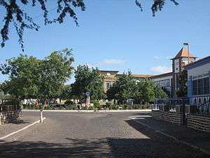
About the Plateau
Numerous streets include Avenida de Andrade Corvo, Rua 5 de Julho, Rua Serpa Pinto, Avenida Amílcar Cabral, etc, the area's main street is Amílcar Cabral.. There are only threestreets accessing the plateau and other parts of the city, two are in the north, one being Av. Amílca Cabral and the other is a ramp in the south connecting the roundabout. Some four or five streets have become pedestrianized, one is the longest and a block of Serpa Pinto. Numerous squares includes Diogo Gomes in the south which features a Diogo Gomes inside the lesser neighborhood of Mirador Diogo Gomes and Albuquerque in the south-center, the largest in the neighborhood. Buildings surrouding the square includes Our Lady of Grace (Nossa Senhora da Graça) Cathedral in the east and the city hall in the south. The other three are in the north, one named Luis de Camões and one being a circle named after Domingos Ramos along with the lyceum.
The city's market takes place in and within Avenida Amílcar Cabral some weekends and much of it is about 500 meters long, one portion is a market square about 60x50 meters just a block north of the square, most of its streets are pedestrianiized and extends east to Rua 5 de Julho.
Government buildings and some embassies are located in the plateau. The headquarters of African Party for the Independence of Cape Verde (PAICV) is in the northern part on Avenida Amílcar Cabral.
Some embassies are located including Belgian, the Dutch (the two are in the same building) located on 2 Rua Patrice Lumumba and the United States Embassy in the north.
Landmarks and points of interest
.jpg)
- Statue of Amílcar Cabral
- City Hall of Praia - south of Albuquerque Square
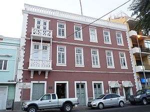
- Museu Etnográfico da Praia - northwest, located on Rua 5 de Julho and the address number is 45
- Escola Grande - Praia's chief elementary school located on Rua António Loreno
- National Justice Palace - east of Albuquerque Square
- Palácio da Cultura Ildo Lobo
- Nazarene Church - northern part
- Liceu Nacional
- Hospital Agostinho Neto
- International Portuguese Language Institute (Instituto Internacional de Língua Portuguesa)
- The Post Office building of Praia, headquarters of Correios de Cabo Verde
- Our Lady of Grace (Nossa Senhora da Graça') Cathedral, the city's cathedral and serves as the parish seat
- Quartel Jaime Mota - southeast part
- Liceu Domingos Ramos - in the north part, Praia's secondary school, it underwent repairs and modifications in 2012, notable students included José Ulisses Correia e Silva who is now Prime Minister of Cape Verde, he received his alma mater there
- Sociedade Cabo-verdiana de Cerveja e Refrigerantes - a beverage factory in the eastern end of the neighborhood
- National Supreme Court Building
Panoramics
It is one part of the city that offers beautiful panoramics including the southern part with Gamboa, Achada Santo Antonio, Vàrzea including the stadium, the National Library and the government building housing the National Assembly and Ilhéu de Santa Maria, the western part of the city with a mountain at the westernmost part and northwest, the island's tallest summit Pico da Antónia, the northcentral part including Eugénio Lima, the eastern part and the Port of Praia.
Transportation
Ten transit lines passes through the plateau often or sometimes, the last three do not cross by the Atlantic, they include:[9]
- São Filipe – Plateau - Achada Santo António
- Ponta d’Água - Plateau - Achada Santo António
- Plateau – Airport
- Achada Mato – Plateau - Meio de Achada
- Palmarejo - Plateau – Achada Grande
- Plateau – Port of Praia
- São Filipe – Plateau - Achada Santo António - second route
- Palmarejo – Plateau – Eugénio Lima
- Terra Branca – Plateau – Pensamento
- São Filipe – Plateau - Achada Santo António - third route crossing inland
Notable people
- Jorge Barbosa, 20th century Cape Verdean writer and poet who wrote Claridade and works related to Cape Verdean independence and nationalism
- António Lopes Cardoso, a Portuguese writer and poet who opposed Salazar and later lived in Brazil and Portugal
References
- ↑ Konstam p.34-42
- ↑ Sugden 185-86
- ↑ Brooks p.99-120
- ↑ "Como estragar uma bela Praça". A Semana (in Portuguese). 30 April 2011. Retrieved 7 February 2012.
- ↑ "Nobreza de Portugal e do Brasil", Direcção de Afonso Eduardo Martins Zúquete, Editorial Enciclopédia, 2.ª Edição, Lisboa, 1989, Volume Terceiro, p. 320
- ↑ "Numbered version of the first edition of Certeza" (in Portuguese). Jean Piaget University of Cape Verde.
- ↑ Tavares p.217
- ↑ "Certeza" (in Portuguese) (3rd ed.). Jean Piaget University of Cape Verde.
- ↑ http://www.asemana.publ.cv/spip.php/mes_squelettes/img/spip.php?article94283&ak=1 (Portuguese)
Bibliography
| Wikimedia Commons has media related to Plateau of Praia. |
- Brooks, George E. Western Africa and Cabo Verde, 1790s-1830s: symbiosis of slave and legitimate trades. pp. 99–120. ISBN 9781452088709. Retrieved 29 October 2016.
- Konstam, Angus (2011). The Great Expedition: Sir Francis Drake on the Spanish Main - 1585-86 (Raid). Osprey Pub. ISBN 978-1849082457.
- Sugden, John (2004). Sir Francis Drake. Penguin Books. ISBN 978-1844137626.
- Eugene Tavares (2009). Littératures lusophones des archipels atlantiques : Açores, Madère, Cap-Vert, São Tomé e Príncipe' [Lusophony Literature in the Atlantic Archipelagoes: Azores, Madeira, Cape Vede and São Tomé and Príncipe]. L'Harmattan. ISBN 9782296075757.
| Neighbourhoods |
|   |
|---|---|---|
| Geographical features | ||
| Major squares | ||
| Major streets and arterials |
| |
| Universities and educational institutions |
| |
| Landmarks and tourism | ||
| Sports facilities and complexes | ||
| Transportation | ||
| Culture |
| |
| History | ||
Coordinates: 14°55′12″N 23°30′26″W / 14.9199°N 23.5071°W