Pixley, Kansas
| Pixley, Kansas | |
|---|---|
| Unincorporated community | |
 Pixley, Kansas  Pixley, Kansas | |
| Coordinates: 37°15′07″N 98°30′49″W / 37.25194°N 98.51361°WCoordinates: 37°15′07″N 98°30′49″W / 37.25194°N 98.51361°W | |
| Country | United States |
| State | Kansas |
| County | Barber |
| Elevation | 1,509 ft (460 m) |
| Time zone | Central (CST) (UTC-6) |
| • Summer (DST) | CDT (UTC-5) |
| Area code(s) | 620 |
| GNIS feature ID | 484519[1] |
Pixley is an unincorporated community in Barber County, Kansas, United States. Pixley is 4 miles (6.4 km) southeast of Medicine Lodge.
History
Pixley had a post office from 1892 until 1897.[2]
References
- ↑ U.S. Geological Survey Geographic Names Information System: Pixley, Kansas
- ↑ "Kansas Post Offices, 1828-1961 (archived)". Kansas Historical Society. Archived from the original on October 9, 2013. Retrieved 4 June 2014.
Municipalities and communities of Barber County, Kansas, United States | ||
|---|---|---|
| Cities | 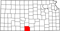 | |
| Unincorporated communities | ||
| Townships | ||
This article is issued from Wikipedia - version of the 7/31/2016. The text is available under the Creative Commons Attribution/Share Alike but additional terms may apply for the media files.