Gerlane, Kansas
| Gerlane, Kansas | |
|---|---|
| Unincorporated community | |
 Gerlane, Kansas  Gerlane, Kansas | |
| Coordinates: 37°09′09″N 98°32′59″W / 37.15250°N 98.54972°WCoordinates: 37°09′09″N 98°32′59″W / 37.15250°N 98.54972°W | |
| Country | United States |
| State | Kansas |
| County | Barber |
| Elevation | 1,398 ft (426 m) |
| Time zone | Central (CST) (UTC-6) |
| • Summer (DST) | CDT (UTC-5) |
| Area code(s) | 620 |
| GNIS feature ID | 484521[1] |
Gerlane is an unincorporated community in Barber County, Kansas, United States. Gerlane is 9 miles (14 km) south of Medicine Lodge.
History
Gerlane once had its own bank, the Gerlane State Bank, chartered in 1917.[2] Gerlane was situated on the Atchison, Topeka and Santa Fe Railway, but declined after the tracks were removed in 1942.[3][4]
A post office was opened in Gerlane in 1909, and remained in operation until it was discontinued in 1943.[5]
References
- ↑ U.S. Geological Survey Geographic Names Information System: Gerlane, Kansas
- ↑ Biennial Report of the Bank Commissioner of the State of Kansas, Volume 15. Kansas. Dept. of Banking. 1920. p. 194.
- ↑ "Abandoned Rails: Kiowa to Gerlane". Abandoned Rails. Retrieved 4 June 2014.
- ↑ "Gerlane, Kansas article from November 1942". Dead towns of Kansas. Retrieved 4 June 2014.
- ↑ "Kansas Post Offices, 1828-1961 (archived)". Kansas Historical Society. Archived from the original on October 9, 2013. Retrieved 4 June 2014.
Municipalities and communities of Barber County, Kansas, United States | ||
|---|---|---|
| Cities | 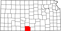 | |
| Unincorporated communities | ||
| Townships | ||
This article is issued from Wikipedia - version of the 10/30/2016. The text is available under the Creative Commons Attribution/Share Alike but additional terms may apply for the media files.