Lake City Township, Barber County, Kansas
| Lake City Township | |
|---|---|
| Township | |
 Location in Barber County | |
| Coordinates: 37°20′00″N 098°48′01″W / 37.33333°N 98.80028°WCoordinates: 37°20′00″N 098°48′01″W / 37.33333°N 98.80028°W | |
| Country | United States |
| State | Kansas |
| County | Barber |
| Area | |
| • Total | 42.08 sq mi (108.99 km2) |
| • Land | 42 sq mi (108.77 km2) |
| • Water | 0.08 sq mi (0.22 km2) 0.2% |
| Elevation | 1,598 ft (487 m) |
| Population (2000) | |
| • Total | 83 |
| • Density | 2/sq mi (0.8/km2) |
| GNIS feature ID | 0470441 |
Lake City Township is a township in Barber County, Kansas, USA. As of the 2000 census, its population was 83.
Geography
Lake City Township covers an area of 42.08 square miles (109.0 km2) and contains no incorporated settlements.
The streams of Cottonwood Creek, Dog Creek, Little Bear Creek, Little Driftwood Creek, Little Mule Creek, Oak Creek, Puckett Creek, Sand Creek and Sand Creek run through this township.
Transportation
Lake City Township contains one airport or landing strip, Mills Landing Strip.
References
External links
- "Lake City, Barber County, Kansas" Barber County, Kansas: History and Genealogy.
- "Reuben Lake " Founder of Lake City, Kansas.
- "Lake City Cemetery " Lake City, Kansas.
- "Oak Creek Ranch" History, geology and maps of a ranch near Lake City, Kansas.
- City-Data.com
Municipalities and communities of Barber County, Kansas, United States | ||
|---|---|---|
| Cities | 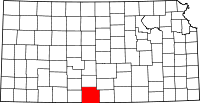 | |
| Unincorporated communities | ||
| Townships | ||
This article is issued from Wikipedia - version of the 6/24/2016. The text is available under the Creative Commons Attribution/Share Alike but additional terms may apply for the media files.