Pirapetinga
| Pirapetinga | ||
|---|---|---|
| Municipality | ||
| ||
| Country |
| |
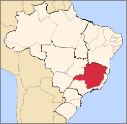
| Region | Southeast | |
| State | Minas Gerais | |
| Mesoregion | Zona da Mata | |
| Time zone | UTC -3 | |

Pirapetinga is a municipality in the state of Minas Gerais in the Southeast region of Brazil.[1][2][3][4] Its estimated population in 2007 was 10,687 inhabitants (IBGE).
Geography
The municipality is located in the Meso-region of Zona da Mata near the border with the State of Rio de Janeiro. It is 379 kilometres (235 mi) by road from the capital of Minas Gerais, Belo Horizonte. It has an area of 192 square kilometres (74 sq mi) including the city itself and two districts: Valão Quente and Caiapó.
Topography, climate, hydrology
The city is at an altitude of 160 metres (520 ft), with the highest point being Pedra Bonita at 797 metres (2,615 ft). The climate is tropical with wet summers and an average annual temperature around 23.5 °C (74.3 °F), with variations between 18 °C (64 °F) (mean minimum) and 31 °C (88 °F) (mean maximum).
The district is watered by the River Pirapetinga a tributary of the Paraíba do Sul.
Highways
BR-393
Demographics
Census Data - 2000
Total Population : 10,034
Urban: 8413 Rural: 1621 Men: 5034 Women: 5000
(Source: AMM )
Population density (inhabitants / km2): 51.8
Infant mortality (per thousand): 25.4
Life expectancy (years): 71.1
Fertility rate (children per woman): 2.2
Literacy Rate: 83.8%
Human Development Index (HDI): 0.759
HDI-M Income: 0.681 HDI-M Longevity: 0.768 HDI-M Education: 0.827
(Source: UNDP / 2000)
History
The city began as a village that grew up around the chapel erected in honour of Saint Anne in 1850. In 1864 the village became a district of Leopoldina with the name of Santana Pirapetinga.
It became independent of the municipality of Além Paraíba in 1938.
See also
References
- ↑ "Divisão Territorial do Brasil" (in Portuguese). Divisão Territorial do Brasil e Limites Territoriais, Instituto Brasileiro de Geografia e Estatística (IBGE). July 1, 2008. Retrieved December 17, 2009.
- ↑ "Estimativas da população para 1º de julho de 2009" (PDF) (in Portuguese). Estimativas de População, Instituto Brasileiro de Geografia e Estatística (IBGE). August 14, 2009. Retrieved December 17, 2009.
- ↑ "Ranking decrescente do IDH-M dos municípios do Brasil" (in Portuguese). Atlas do Desenvolvimento Humano, Programa das Nações Unidas para o Desenvolvimento (PNUD). 2000. Retrieved December 17, 2009.
- ↑ "Produto Interno Bruto dos Municípios 2002-2005" (PDF) (in Portuguese). Instituto Brasileiro de Geografia e Estatística (IBGE). December 19, 2007. Archived from the original (PDF) on October 2, 2008. Retrieved December 17, 2009.
Capital: Belo Horizonte | |||||||||||||||||||||||||||||||||||||||||||||
|  | ||||||||||||||||||||||||||||||||||||||||||||
|
| |||||||||||||||||||||||||||||||||||||||||||||
| |||||||||||||||||||||||||||||||||||||||||||||
| |||||||||||||||||||||||||||||||||||||||||||||
| |||||||||||||||||||||||||||||||||||||||||||||
| |||||||||||||||||||||||||||||||||||||||||||||
| |||||||||||||||||||||||||||||||||||||||||||||
| |||||||||||||||||||||||||||||||||||||||||||||
| |||||||||||||||||||||||||||||||||||||||||||||
| |||||||||||||||||||||||||||||||||||||||||||||
| |||||||||||||||||||||||||||||||||||||||||||||
Coordinates: 21°39′21″S 42°20′45″W / 21.65583°S 42.34583°W