Ewbank da Câmara
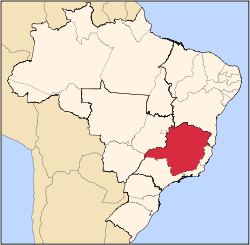
Ewbank da Câmara is a municipality in the state of Minas Gerais, Brazil. Belonging to the mesoregion of the Zona da Mata and the microregion of Juiz de Fora, the municipality is located some 241 km to the southeast of the state capital, Belo Horizonte. In 2014, its population was 3,914, according to the Brazilian Institute of Geography and Statistics. It occupies an area of 103.834 km². The urban area of the municipality constitutes a small part of the total. The rural area, predominantly in the municipality, has Atlantic rainforest vegetation.
The city has its origin connected to the railway station Ewbank da Câmara of the railway Dom Pedro II transformed into Brazil's Central Railroad. The railway station opened on 12 October 1890 in the village of Tabuões. Around the station, the small town developed and was elevated to district on 7 September 1923, being it inaugurated on 6 January 1926, and to municipality on 30 December 1962, emancipated from Santos Dumont. The name of the municipality was a tribute to the engineer José Felipe Neri Ewbank da Câmara, then director of the railroad. The first municipal administration took office on 1 September 1963 with the mayor Mr. Jair Antonio da Silva. In 2010, the Municipal Human Development Index (MHDI) was 0.676 which is considered as an average index in relation to the state.[3] The city is part of the commercial, industrial and services axis of nearby towns connected by BR 040, to the North, Santos Dumont, and to the South, Juiz de Fora.
The municipality has evolved from a rural culture (agriculture and animal husbandry), which is still present in the city life, to an urban culture. In 2009, its GDP reached R$19.5 million with a GDP per capita of R$5,307.42.[4] Even having local commercial, industrial, and services activities, it serves as a dormitory town for those who work and study mainly in Juiz de Fora. The highlight is tourism for visitors interested in exploring historical trails of the Royal Road and the living nature with the tranquility of the lake that was formed from the Chapéu D’Úvas Dam.[5] Its main football team is the Ewbankense Sport Club, founded in 1947. One of the main events is the festival of St. Anthony, the patron of the city.
References
- ↑ "Divisão Territorial do Brasil, Resolução da Presidência do IBGE PR-04, 22/12/2014" (in Portuguese). Divisão Territorial do Brasil e Limites Territoriais, Instituto Brasileiro de Geografia e Estatística (IBGE). December 23, 2014. Retrieved January 27, 2015.
- ↑ "Cidades@IBGE" (HTML) (in Portuguese). Estimativas de População, Instituto Brasileiro de Geografia e Estatística (IBGE). August 28, 2014. Retrieved January 27, 2015.
- ↑ "Ranking decrescente do IDH-M dos Municípios do Brasil" (HTML) (in Portuguese). Atlas do Desenvolvimento Humano, Programa das Nações Unidas para o Desenvolvimento (PNUD). 2010. Retrieved January 27, 2015.
- ↑ "Produto Interno Bruto dos Municípios 2005-2009" (PDF) (in Portuguese). Instituto Brasileiro de Geografia e Estatística (IBGE). December 12, 2011. Retrieved January 27, 2015.
- ↑ "Para onde você quer ir: Ewbank da Câmara" (in Portuguese). Instituto Estrada Real. 2014. Retrieved January 27, 2015.
|
|---|
|
|
|
| Mesoregion Campo das Vertentes |
|---|
| Barbacena | |
|---|
| Lavras | |
|---|
| São João del Rei | |
|---|
|
| |
|
| Mesoregion Central Mineira |
|---|
| Bom Despacho | |
|---|
| Curvelo | |
|---|
| Três Marias | |
|---|
|
|
|
| Mesoregion Jequitinhonha |
|---|
| Almenara | |
|---|
| Araçuaí | |
|---|
| Capelinha | |
|---|
| Diamantina | |
|---|
| Pedra Azul | |
|---|
|
|
|
| Mesoregion Metropolitana de Belo Horizonte |
|---|
| Belo Horizonte | |
|---|
| Conceição do Mato Dentro | |
|---|
| Conselheiro Lafaiete | |
|---|
| Itabira | |
|---|
| Itaguara | |
|---|
| Ouro Preto | |
|---|
| Pará de Minas | |
|---|
| Sete Lagoas | |
|---|
|
|
|
| Mesoregion Noroeste de Minas |
|---|
| |
|
|
| Mesoregion Norte de Minas |
|---|
| Bocaiúva | |
|---|
| Grão Mogol | |
|---|
| Janaúba | |
|---|
| Januária | |
|---|
| Montes Claros | |
|---|
| Pirapora | |
|---|
| Salinas | |
|---|
|
|
|
| Mesoregion Oeste de Minas |
|---|
| Campo Belo | |
|---|
| Divinópolis | |
|---|
| Formiga | |
|---|
| Oliveira | |
|---|
| Piui | |
|---|
|
|
|
| Mesoregion Sudoeste de Minas |
|---|
| Alfenas | |
|---|
| Andrelândia | |
|---|
| Itajubá | |
|---|
| Passos | |
|---|
| Poços de Caldas | |
|---|
| Pouso Alegre | |
|---|
| Santa Rita do Sapucaí | |
|---|
| São Lourenco | |
|---|
| São Sebastiao do Paraíso | |
|---|
| Varginha | |
|---|
|
|
|
| Mesoregion Triângulo Mineiro/Alto Paranaiba |
|---|
| Araxá | |
|---|
| Frutal | |
|---|
| Ituiutaba | |
|---|
| Patos de Minas | |
|---|
| Patrocínio | |
|---|
| Uberaba | |
|---|
| Uberlândia | |
|---|
|
|
|
| Mesoregion Vale do Mucuri |
|---|
| |
|
|
| Mesoregion Zona da Mata |
|---|
| Cataguases | |
|---|
| Juiz de Fora | |
|---|
| Manhuaçu | |
|---|
| Muriaé | |
|---|
| Ponte Nova | |
|---|
| Ubá | |
|---|
| Viçosa | |
|---|
|
|
|
| Mesoregion Vale do Rio Doce |
|---|
| Aimorés | |
|---|
| Caratinga | |
|---|
| Governador Valadares | |
|---|
| Guanhães | |
|---|
| Ipatinga | |
|---|
| Mantena | |
|---|
| Peçanha | |
|---|
|
|
Coordinates: 21°33′03″S 43°30′36″W / 21.5508°S 43.51°W / -21.5508; -43.51