Orangeville, Ontario
| Orangeville | ||
|---|---|---|
| Town (lower-tier) | ||
| Town of Orangeville | ||
 | ||
| ||
| Nickname(s): O'Ville | ||
| Motto: "Historic Charm -- Dynamic Future" | ||
 Location of Orangeville within Dufferin County | ||
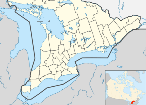 Orangeville Location of Orangeville in southern Ontario | ||
| Coordinates: 43°55′N 80°7′W / 43.917°N 80.117°WCoordinates: 43°55′N 80°7′W / 43.917°N 80.117°W | ||
| Country |
| |
| Province |
| |
| County | Dufferin | |
| Incorporated | 1863 (village) | |
| Incorporated | 1873 (town) | |
| Government | ||
| • Mayor | Jeremy D Williams | |
| • Deputy Mayor | Warren Maycock | |
| • Councillors | Don Kidd, Gail Campbell, Sylvia Bradley, Scott Wilson, Nick Garisto | |
| Area[1][2] | ||
| • Town (lower-tier) | 15.61 km2 (6.03 sq mi) | |
| • Urban | 31.16 km2 (12.03 sq mi) | |
| Elevation[3] | 411.50 m (1,350.07 ft) | |
| Population (2011)[1][2] | ||
| • Town (lower-tier) | 27,975±0 | |
| • Urban | 30,729 | |
| • Urban density | 990/km2 (2,600/sq mi) | |
| Time zone | EST (UTC-5) | |
| • Summer (DST) | EDT (UTC-4) | |
| Postal code | L9W | |
| Area code(s) | 519 and 226 | |
| Highways |
| |
| Website | Town of Orangeville | |

Orangeville (UA population 30,729) is a town in south-central Ontario, Canada, and the seat of Dufferin County.
History

The archeological record in Dufferin County dates indigenous occupation of the area to the "early Paleo-Indian" time period from 9000 to 8400 BCE.[4] What eventually became Orangeville and Dufferin County, was historically the traditional territory of the Tionontati or Petún (Tobaco) People. "The Petun occupied from eight to ten villages located below the Niagara Escarpment along the southwest margin of Georgian Bay".[5] Although described in the Encyclopædia Britannica as "living in the mountains south of Nottawasaga Bay, in what are now Grey and Simcoe counties",[6] according to Sawden's "A History of Dufferin County" the Petún also lived farther south at the source of the Grand River in Dufferin County.[7]
The Petún were decimated by European diseases in 1630s, going from a population of approximately 8000 to 3000, and were subsequently attacked by the Iroquois in December of 1649 further reducing their numbers to fewer than 1000. They then fled along with other Huron peoples into the United States, while other Petún sought refuge with their French allies and settled in Quebec.[8][5][9] This Iroqouis attack was not exclusive to the Petún, but was a part of the Beaver Wars, in which the Iroquois sought to expand their territory and monopolize the fur trade, the trade between European markets, and the trade between tribes of the Great Lakes region.[lower-alpha 1]
After the decimation and dispersal of the Huron, Petún, and Neutral people of southern Ontario, Algonkian peoples from northern Ontario moved into the area at the end of the 17th century and the beginning of the 18th century, while members of the Three Fires Confederacy (Chippewa, Odawa, Potawatomi) moved into southern Ontario from Ohio and Michigan in the late 1700s.[11] During the pre-confederation Treaty era, Anishinaabe or Chippewa First Nations signed Treaty #18 on Oct 17th, 1818, which included the Dufferin County area.[12][lower-alpha 2] Today, the descendants of Petún call themselves Wyandotte, and despite the 350 years since their displacement from southern Ontario, and despite the heteroglot and diasporic nature of their contemporary communities (located in Oklahoma, Michigan, Kansas, and Quebec), they continue to recognize their shared history and are united through a modern-day Wyandotte Confederacy.[13][14]
 The house of Orangeville founder Orange Lawrence as it stands today. |
The first patent of land was issued to Ezekiel Robinson, a land surveyor, on August 7, 1820. This was followed by land issued to Alan Robinet in 1822. In 1863, Orangeville was named after Orange Lawrence, a businessman born in Connecticut in 1796 who owned several mills in the village. As a young man, he moved to Canada and settled in Halton County. During Mackenzie's rebellion in 1837, he was a captain in the militia. Lawrence purchased the land that became Orangeville from Robert Hughson.[15] Orange Lawrence committed suicide December 15, 1861.[16] In 1873, the Act of Incorporation was passed and Orangeville was given town status on January 1, 1874. The public library, located at Broadway and Mill Street, was completed in 1908. Andrew Carnegie, well-known businessman and philanthropist, provided financial assistance for its construction. |
Economy and finance
Orangeville serves as an administrative and commercial hub for Dufferin County, the northern portion of Peel Region and the surrounding area. Orangeville's downtown core is home to several retail stores, and there is a cluster of big-box stores in the Fairgrounds Shopping Centre. Many residents in and around Orangeville also commute to other areas of the Greater Toronto Area for work.
There are a number of manufacturing plants located in the town. Major industrial employers include Greening Donald (automotive airbag components), Resolve Corporation (computer outsourcing), Clorox Company of Canada (Glad garbage bags), Relizon Canada (pressure-sensitive labels), Rochling Engineering Plastics (formerly Symplastics Limited )(plastic sheets) and Sanoh Canada (automotive components). Orangeville is also the main banking centre for residents in the area.
Transportation and infrastructure

The main intersection in the heart of the town is Broadway (formerly Ontario Highway 9) and First Street. Highway 10 runs through Orangeville on its east side.
Beginning in 2005, a major roadwork project was initiated to resurface Broadway through Orangeville. The downtown section was completed in early 2006, with extensive work still to be done on the west end in late 2006. In conjunction with this project, there was another one completed in late 2006 that involved building large planters in the middle of Broadway through the downtown section between First and Third Streets (West - East). The project was controversial, as safety concerns had been raised by the Fire Department because the new concrete planters in the middle of the road have made the rights of way too narrow for fire trucks to properly set up in case of a fire in a downtown building.
Construction of the South Arterial Road, often referred to as the 'Orangeville by-pass', was completed on August 3, 2005.[17] The road runs from east to west, connecting Highway 10 and County Road 109 (formerly Highway 9). Much of the eastern stretch runs through the Town of Caledon, but officially enters into Orangeville at the Townline Road controlled intersection.
Aecon Construction and Materials Limited was the successful bidder for the Design Build project with a price of $9.8 million. The project was completed in conjunction with Brampton-based Armbro Construction, TSH Engineers Architects Planners, Peto MacCallum Ltd. and Gartner Lee Ltd.
Orangeville Transit is the town's own public transit system, and there is a commuter GO Transit bus service to Brampton. In the early 1990s, preliminary plans were drawn up for GO Transit rail service to Orangeville. However, it never got past the drawing board.
Industries in Orangeville are served by the Orangeville-Brampton Railway, which purchased 55 kilometres (34 mi) of surplus track from the Canadian Pacific Railway. The railway connects with the CPR in Streetsville, and also services customers in Brampton to the south.
About 100 years ago, survey work was underway for an electric railway line which would serve Orangeville, the Huron and Ontario Electric Railway.[18]
Demographics
| Historical populations | ||
|---|---|---|
| Year | Pop. | ±% |
| 1871 | 1,458 | — |
| 1881 | 2,847 | +95.3% |
| 1891 | 2,962 | +4.0% |
| 1901 | 2,511 | −15.2% |
| 1911 | 2,340 | −6.8% |
| 1921 | 2,187 | −6.5% |
| 1931 | 2,614 | +19.5% |
| 1941 | 2,718 | +4.0% |
| 1951 | 3,249 | +19.5% |
| 1961 | 4,593 | +41.4% |
| 1971 | 8,074 | +75.8% |
| 1981 | 13,740 | +70.2% |
| 1991 | 17,921 | +30.4% |
| 1996 | 21,498 | +20.0% |
| 2001 | 25,248 | +17.4% |
| 2006 | 26,925 | +6.6% |
| 2011 | 27,975 | +3.9% |
According to the 2011 Canadian Census,[19] the population of Orangeville is 27,975, a 3.9% increase from 2006, with a 1.22% per annum average growth rate over the same period. The area is 15.61 km2 (6.03 sq mi), giving a population density of 1,800/km2 (4,700/sq mi). The median age is 37.3 years, lower than the national median age of 40.6 years. There are 10,265 private dwellings with an occupancy rate of 98.1%. According to the 2011 National Household Survey,[20] the median value of a dwelling in Orangeville is $299,173, higher than the national average at $280,552. The median household income (after-taxes) in Orangeville is $65,040, higher than the national average at $54,089.
Orangeville inhabitants are predominantly of European descent. The racial composition of Orangeville is:
- 92.8% White
- 1.7% Aboriginal; 1.1% First Nations, 0.1% Métis
- 1.6% Black
- 1.0% South Asian
- 0.9% Southeast Asian; 0.7% Filipino
- 0.7% East Asian; 0.4% Chinese, 0.0% Korean, 0.3% Japanese
- 0.4% Latin American
- 0.1% Arab
- 0.0% West Asian
- 0.2% Multiracial[lower-alpha 3]
- 0.6% Other
Education
Upper Grand District School Board operates secular anglophone public schools. The Dufferin-Peel Catholic District School Board operates anglophone catholic public schools. The Conseil scolaire Viamonde operates secular francophone schools serving the area. The Conseil scolaire de district catholique Centre-Sud operates catholic francophone schools serving the area.
There are currently eleven public and separate elementary schools in Orangeville: Credit Meadows, Mono Amaranth, Montgomery Village, Parkinson Centennial, Princess Elizabeth, Princess Margaret, St. Andrew's RC, St. Benedict's RC, St. Peter's RC, Island Lake Public School and Spencer Avenue Elementary, as well as a holding school, formerly Springbrook Elementary. Along with these publicly funded schools, there are several private schools in the area: Headwater Hills Montessori School, Dufferin Area Christian School, Hillcrest Private School, The Maples Independent Country School, Orangeville Christian School.
A French elementary school named L'École élémentaire de Quatre-rivièrs (Translated to The elementary school of four rivers) currently resides in the old Springbrook Elementary building despite the reason for closing the school being 'structural' problems. Most of these problems are said to be the result of 'improper foundation for the area' as the school was built upon a swamp.[lower-alpha 4] It is currently being used as a holding school that other schools including Island Lake, Montgomery Village, and Princess Margaret, have used while repairs, renovations, rebuilds and construction were completed.
There are two secondary schools within the boundaries of Orangeville: Westside Secondary School and Orangeville District Secondary School (ODSS). A catholic secondary school Robert F. Hall Catholic Secondary School draws around 1000 students from Orangeville and the rest of the county despite being within the Region of Peel.
Humber College is scheduled to offer full-time programs in Fall 2007 at a temporary location at the Alder Street arena. A new campus was planned on an 11-hectare (28-acre) site located on Veteran's Way. The first phase of the new facility is planned to open in late fall 2007 or early 2008. Upon opening, the campus is expected to accommodate up to 400 students, expanding to 2,000 by 2017. As of July 2016, Humber is still run out of Alder Street arena.
Georgian College currently owns and operates a campus offering full & part-time courses located at 22 Centennial Road. It is also delivering Employment programs and services out of a location on 51 Townline.
Culture

Orangeville is the cultural capital of Dufferin County. Orangeville hosts the annual Orangeville Blues & Jazz Festival which is renowned throughout the region.
The Town Hall building contains the Orangeville Theatre. This facility hosts plays and concerts throughout the year. A number of performances have given the Orangeville Theater a reputation for excellence.
Local artists have made their mark on Orangeville as well. Numerous old maple trees which had died due to age in recent years were carved into large sculptures.
Sports
The Orangeville Flyers are a Junior 'A' ice hockey team who are a part of the Ontario Junior Hockey League. They play home games at the Alder Street Recreation Facility. Orangeville is also home to a professional basketball team, the Orangeville A's of the National Basketball League of Canada, who play at the Orangeville Athletic Institute.
Media
The local radio station, CIDC, formerly targeted its news and variety programming out of Orangeville to southern Huronia. However, it subsequently became a top-40 station targeting Toronto and the Greater Toronto Area. The signals have been moved southeast to increase coverage into Greater Toronto, and studios have been moved to the Toronto community of Etobicoke. Orangeville is also mainly served by many Radio stations in Toronto transmitting from the CN Tower.
There are two local newspapers based in Orangeville, the Orangeville Citizen and the Orangeville Banner.
Until June 2005, Rogers Television maintained its Peel North studio and production facility at 98 C-Line. The facility was closed to allow for expansion of the Peel North headend. Rogers is the cable provider for Orangeville.
In July, 2014, the CRTC approved an application by My Broadcasting for a broadcasting licence to operate an English-language commercial FM radio station in Orangeville. The new station will provide Orangeville and its residents with a dedicated local radio service that will fulfill specific requirements relating to local Orangeville programming, including the broadcast of announcements that are reflective of its standing as a community distinct and separate from Toronto.
Government and politics
Orangeville is located in provincial electoral district of Dufferin—Caledon. This was changed from Dufferin—Peel—Wellington—Grey when the Province instituted the 107 electoral districts revision in 2006. Its current Member of Provincial Parliament is Sylvia Jones, former assistant to Progressive Conservative Party of Ontario leader, John Tory. Federally, Orangeville is located in the Dufferin—Caledon electoral district. Its elected Member of Parliament is currently David Tilson of the Conservative Party.
Climate
| Climate data for Orangeville Moe 1981–2010 | |||||||||||||
|---|---|---|---|---|---|---|---|---|---|---|---|---|---|
| Month | Jan | Feb | Mar | Apr | May | Jun | Jul | Aug | Sep | Oct | Nov | Dec | Year |
| Record high °C (°F) | 14.5 (58.1) |
13.0 (55.4) |
22.5 (72.5) |
28.5 (83.3) |
32.0 (89.6) |
34.0 (93.2) |
35.0 (95) |
35.5 (95.9) |
33.0 (91.4) |
28.3 (82.9) |
22.8 (73) |
18.0 (64.4) |
35.5 (95.9) |
| Average high °C (°F) | −3.4 (25.9) |
−2.1 (28.2) |
2.8 (37) |
10.6 (51.1) |
17.6 (63.7) |
22.8 (73) |
25.2 (77.4) |
24.2 (75.6) |
19.9 (67.8) |
12.7 (54.9) |
5.6 (42.1) |
−0.6 (30.9) |
11.3 (52.3) |
| Daily mean °C (°F) | −7.5 (18.5) |
−6.5 (20.3) |
−2.1 (28.2) |
5.3 (41.5) |
11.7 (53.1) |
16.9 (62.4) |
19.4 (66.9) |
18.4 (65.1) |
14.3 (57.7) |
7.8 (46) |
2.0 (35.6) |
−4.1 (24.6) |
6.3 (43.3) |
| Average low °C (°F) | −11.6 (11.1) |
−10.9 (12.4) |
−7.0 (19.4) |
0.0 (32) |
5.7 (42.3) |
10.9 (51.6) |
13.5 (56.3) |
12.6 (54.7) |
8.7 (47.7) |
3.0 (37.4) |
−1.7 (28.9) |
−7.5 (18.5) |
1.3 (34.3) |
| Record low °C (°F) | −36.0 (−32.8) |
−36.5 (−33.7) |
−34.4 (−29.9) |
−20.0 (−4) |
−6.1 (21) |
−2.2 (28) |
0.6 (33.1) |
−1.1 (30) |
−5.6 (21.9) |
−10.6 (12.9) |
−18.0 (−0.4) |
−33.0 (−27.4) |
−36.0 (−32.8) |
| Average precipitation mm (inches) | 64.3 (2.531) |
54.5 (2.146) |
60.9 (2.398) |
70.1 (2.76) |
86.6 (3.409) |
81.3 (3.201) |
80.8 (3.181) |
88.2 (3.472) |
87.0 (3.425) |
76.6 (3.016) |
87.1 (3.429) |
64.2 (2.528) |
901.5 (35.492) |
| Average rainfall mm (inches) | 25.7 (1.012) |
22.7 (0.894) |
38.2 (1.504) |
63.5 (2.5) |
86.6 (3.409) |
81.3 (3.201) |
80.8 (3.181) |
88.2 (3.472) |
87.0 (3.425) |
74.3 (2.925) |
72.4 (2.85) |
29.4 (1.157) |
750.1 (29.531) |
| Average snowfall cm (inches) | 38.5 (15.16) |
31.8 (12.52) |
22.7 (8.94) |
6.6 (2.6) |
0.0 (0) |
0.0 (0) |
0.0 (0) |
0.0 (0) |
0.0 (0) |
2.3 (0.91) |
14.7 (5.79) |
34.9 (13.74) |
151.5 (59.65) |
| Average precipitation days (≥ 0.2 mm) | 14.3 | 10.9 | 11.3 | 12.2 | 12.9 | 11.9 | 10.5 | 11.9 | 12.2 | 14.3 | 14.6 | 14.1 | 151.0 |
| Average rainy days (≥ 0.2 mm) | 3.6 | 3.3 | 5.6 | 10.7 | 12.9 | 11.9 | 10.5 | 11.9 | 12.2 | 14.0 | 10.8 | 4.5 | 112.0 |
| Average snowy days (≥ 0.2 cm) | 11.3 | 8.1 | 6.2 | 1.9 | 0.0 | 0.0 | 0.0 | 0.0 | 0.0 | 0.8 | 4.5 | 10.0 | 42.8 |
| Source: Environment Canada[21] | |||||||||||||
Famous residents
- Nana Attakora, MLS, defender currently playing with Toronto FC
- Keith Beavers, Olympic swimmer (2004 and 2008)
- Sarah Bonikowsky, Olympic rower (2008)
- Borealis, power metal band
- Brian Buchanan, member of Enter the Haggis
- Ryan Cooley, actor who portrayed J.T. Yorke on Degrassi: The Next Generation
- Adam Copeland, WWE Hall of Famer, retired professional wrestler/actor better known as Edge
- Nick Cvjetkovich, professional wrestler better known as Kizarny in WWE and Sinn in TNA
- Robertson Davies, author, died in December 1995 at Orangeville
- DVBBS, famous for Tsunami (DVBBS and Borgeous song), electronic music duo
- Dan Ellis goalie for the Florida Panthers of the NHL, former Orangeville Crushers goalie
- Laurie Graham, represented Canada at 3 Olympic games in downhill skiing and won 6 World Cup races
- Orange Jull, inventor who improved upon J.W. Elliot's design of the railway (1880s)[22]
- Thon Maker, alumnus of the Athlete Institute and 2016 draft pick of the Milwaukee Bucks
- Josh McConnell, technology and business journalist known for work in National Post, The Globe and Mail and CBC News
- Jamal Murray, alumnus of the Athlete Institute and 2016 draft pick of the Denver Nuggets
- Jason Reso, WWE and TNA World Champion, retired professional wrestler better known as Christian Cage and Christian
- Brett Ritchie, prospect for the Dallas Stars, NHL
- Nick Ritchie, prospect for the Anaheim Ducks, NHL
Orangeville has produced a number of notable National Lacrosse League players, including:
- Bruce Codd
- Pat Coyle, NLL Defensive Player of the Year in 2002
- Rusty Kruger
- Brodie Merrill, NLL Rookie of the Year and Defensive Player of the Year in 2006
- Brandon Miller
- the Sanderson family, including Terry, Nathan, Josh, Phil, and Chris
- Dillon Ward, NLL, MVP of 2014 World Lacrosse Championships
Accolade
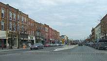
On November 4, 2015, The Canadian Institute of Planners announced winners of its fifth annual Great Places in Canada contest. A jury of seven professional planners named Broadway as the Great Street. "The jury was impressed by the central role Broadway plays in the Orangeville community, along with the heritage character and streetscape design."[23]
Notes
- ↑ The Iroquois would also have been affected by population decline from European diseases, and that they were known for adopting large numbers of captives from rival nations to become members of their own society. This would have compensated for the loss of life in their own communities and bolstered their own population, so many of the Petún likely became assimilated into Iroquois Nations.[10]
- ↑ Similarly, other areas of southern Ontario that were once the traditional territory of the Huron and Neutral, also became part of Treaties signed by Chippewa groups.
- ↑ 0.3% including Métis
- ↑ Because of this the intermediate (grade 7-8) yard area is known to gain a large pond in the spring, about 1 1⁄2 feet (45.7 cm) deep at the deepest point. This pond is referred to as Springbrook Lake by students and staff. A second smaller pond, only about 1 foot (30.5 cm) at its very deepest, appears in the primary (grades 1-3) yard. This is referred to as Springbrook Pond.
References
- 1 2 "Orangeville, Ontario (Code 3522014) census profile". 2011 Census of Population. Statistics Canada. Retrieved 2012-08-14.
- 1 2 "Orangeville (Population Centre), Ontario (Code 0609) census profile". 2011 Census of Population. Statistics Canada. Retrieved 2012-08-14.
- ↑ Canadian Climate Normals 1971-2000, Environment Canada. Retrieved May 19, 2012.
- ↑ Zigomanis, Halo. "Stage 2 Archaeological Assessment - Grand Valley Wind Farms" (PDF). Retrieved January 3, 2014.
- 1 2 Ramsden, Peter G. "Petun". The Canadian Encyclopedia. Retrieved December 29, 2013.
- ↑ "Tionontati". Encyclopedia Britannica. Retrieved December 29, 2013.
- ↑ Sawden, Stephen (1952). History of Dufferin County. p. 7.
- ↑ Sultzman, Lee. "TIONONTATI HISTORY". Retrieved December 29, 2013.
- ↑ "The Tionontatehronnon (Petun)". Retrieved December 29, 2013.
- ↑ http://www.lagrange.edu/resources/pdf/citations08/CULTURALASPECTSOFWARFARE.pdf
- ↑ Zigomanis, Hali. "Stage 2 Archaelogical Assessment - Grand Valley Wind Farms" (PDF). Retrieved January 3, 2014.
- ↑ "Stage 1 Archaeology Assessment - Summerhaven Wind Energy Centre" (PDF). Retrieved January 3, 2013.
- ↑ "Wyandotte Nation". Retrieved January 5, 2013.
- ↑ "Nations of the Wyandotte". Retrieved December 5, 2014.
- ↑ Source: The Orangeville Banner, March 8, 1951
- ↑ http://www.geni.com/people/Orange-Lawrence/6000000011198110820
- ↑ http://dcnonl.com/csp/63985
- ↑ Orangeville Citizen: Survey under way for electric railway across Dufferin
- ↑ NHS Profile of Orangeville: http://www12.statcan.gc.ca/nhs-enm/2011/dp-pd/prof/details/page.cfm?Lang=E&Geo1=CSD&Code1=3522014&Data=Count&SearchText=orangeville&SearchType=Begins&SearchPR=01&A1=All&B1=All&Custom=&TABID=1
- ↑ NHS Profile of Orangeville: http://www12.statcan.gc.ca/nhs-enm/2011/dp-pd/prof/details/page.cfm?Lang=E&Geo1=CSD&Code1=3522014&Data=Count&SearchText=orangeville&SearchType=Begins&SearchPR=01&A1=All&B1=All&Custom=&TABID=1
- ↑ "Orangeville". Canadian Climate Normals 1981−2010. Environment Canada. Retrieved 2016-05-12.
- ↑ Rotary Snowplow
- ↑ http://www.cip-icu.ca/Media/News-Releases/And-the-Winners-of-Great-Places-in-Canada-2015-are#
External links
| Wikimedia Commons has media related to Orangeville, Ontario. |
 |
Amaranth | Mono | | |
| East Garafraxa | |
Caledon | ||
| ||||
| | ||||
| Caledon |