Ohio State Route 165
| ||||
|---|---|---|---|---|
 | ||||
| Route information | ||||
| Maintained by ODOT | ||||
| Length: | 32.31 mi[1] (52.00 km) | |||
| Existed: | 1923[2][3] – present | |||
| Major junctions | ||||
| West end: |
| |||
|
| ||||
| East end: |
Taggart Road to | |||
| Location | ||||
| Counties: | Mahoning, Columbiana | |||
| Highway system | ||||
| ||||

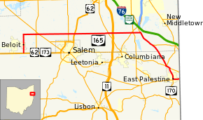
State Route 165 (SR 165) is a 32-mile (51 km) long, primarily east–west running state route located in Mahoning and Columbiana counties in northeast Ohio. The route runs through generally rural sections of southern Mahoning County, and serves East Palestine in extreme northeast Columbiana County. The route connects quite a few unincorporated villages in southern Mahoning County as it passes through. The western terminus is at U.S. Route 62 and State Route 173 just south of Beloit, and the eastern terminus is at the Pennsylvania state line just to the east of East Palestine, where it becomes Taggart Road and heads toward Pennsylvania Route 51.
History
SR 165 was original established in 1923. It was originally routed from North Lima to East Palestine.[2][3] In 1937 the route was extended to Beloit along previous unnumbered road.[4][5] The highway was rerouted from Unity to Pennsylvania state line along previous Route 14, in 1946.[6][7] Between 1969 and 1971 the route was extended to 1-mile (1.6 km) south of Beloit along previous Route 173.[8][9]
Major intersections
| County | Location | mi[1] | km | Destinations | Notes |
|---|---|---|---|---|---|
| Mahoning | Smith Township | 0.00 | 0.00 | ||
| Goshen Township | 5.03 | 8.10 | |||
| 5.46 | 8.79 | ||||
| Green–Goshen township line | 10.21 | 16.43 | |||
| Green Township | 11.21 | 18.04 | |||
| Beaver Township | 16.64 | 26.78 | |||
| 20.33 | 32.72 | ||||
| 20.62 | 33.18 | ||||
| 21.80 | 35.08 | Southern terminus of SR 626 | |||
| New Springfield | 24.61 | 39.61 | Western terminus of SR 617 | ||
| Columbiana | Unity Township | 28.70 | 46.19 | Western end of SR 14 concurrency | |
| 28.78 | 46.32 | Western end of SR 170 concurrency | |||
| 29.32 | 47.19 | Eastern end of SR 14 concurrency | |||
| East Palestine | 31.20 | 50.21 | Eastern end of SR 170 concurrency | ||
| Unity Township | 32.31 | 52.00 | Taggart Road to | Pennsylvania state line | |
1.000 mi = 1.609 km; 1.000 km = 0.621 mi
| |||||
References
- 1 2 Ohio Department of Transportation. "Technical Services Straight Line Diagrams". Retrieved April 30, 2010.
- 1 2 Ohio Department of Highways and Public Works (April 1922). Map of Ohio State Highways (MrSID) (Map). Columbus: Ohio Department of Highways and Public Works. Retrieved September 12, 2013.
- 1 2 Ohio Department of Highways and Public Works (July 1923). Map of Ohio Showing State Routes (MrSID) (Map). 1:760,320. Columbus: Ohio Department of Highways and Public Works. Retrieved September 12, 2013.
- ↑ Ohio Department of Highways (1936). Official Highway Map of Ohio (MrSID) (Map). 1:760,320. Columbus: Ohio Department of Highways. OCLC 5673562. Retrieved September 12, 2013.
- ↑ Ohio Department of Highways (1937). Official Highway Map of Ohio (MrSID) (Map). 1:633,600. Columbus: Ohio Department of Highways. OCLC 5673562, 16960304. Retrieved September 12, 2013.
- ↑ Ohio Department of Highways (1945). Official Highway Map of Ohio (MrSID) (Map). 1:633,600. Columbus: Ohio Department of Highways. OCLC 5673562. Retrieved September 12, 2013.
- ↑ Ohio Department of Highways (1946). Official Highway Map of Ohio (MrSID) (Map). 1:633,600. Columbus: Ohio Department of Highways. OCLC 5673562, 13655772. Retrieved September 12, 2013.
- ↑ Ohio Department of Highways (1969). Official Highway Map of Ohio (MrSID) (Map). Columbus: Ohio Department of Highways. OCLC 5673562, 7448779. Retrieved September 12, 2013.
- ↑ Ohio Department of Highways (1971). Official Highway Map of Ohio (MrSID) (Map). 1:554,400. Columbus: Ohio Department of Highways. OCLC 5673562. Retrieved September 12, 2013.