Pennsylvania Route 51
| ||||
|---|---|---|---|---|
 | ||||
| Route information | ||||
| Maintained by PennDOT | ||||
| Length: | 89 mi[1] (143 km) | |||
| Existed: | 1929 – present | |||
| Major junctions | ||||
| South end: |
| |||
|
| ||||
| North end: |
| |||
| Location | ||||
| Counties: | Allegheny, Fayette, Westmoreland, Beaver | |||
| Highway system | ||||
| ||||

Pennsylvania Route 51 (PA 51) is a major state highway in Western Pennsylvania. It runs for 89 miles (143 km) from Uniontown to the Ohio state line near Darlington, where it connects with Ohio State Route 14. Route 51 is the termination point for Pennsylvania Route 43, Pennsylvania Route 48 and Pennsylvania Route 88. Century III Mall is located on this road in West Mifflin. The Route is a major connection from Uniontown and the rest of Fayette County to Pittsburgh.
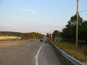
The highway is four-lane highway south of Pittsburgh as it passes through Pittsburgh's South Hills, but narrows to a two-lane road through several boroughs along the Ohio River. It becomes four lanes again after passing Chippewa Township, Beaver County, Pennsylvania in Beaver County and continues to the Ohio border. In the South Hills, Route 51 (Saw Mill Run Blvd.), along with US 19, is one of the major routes in and out of Pittsburgh, as it provides access to several bridges and tunnels. Route 51 is one of the highways that enters the West End Circle, an intersection in the West End.
Route description
Fayette County
PA 51 begins as Pittsburgh Street in downtown Uniontown at an intersection with U.S. Route 40 Business. As Route 51 heads north, it exits Uniontown and intersects with U.S. Route 119, Uniontown's bypass. North of US 119, PA 51 is a rural, multi-lane divided highway that is also known as Pittsburgh Road. In North Union Township, Route 51 divides for 0.7 miles (1.1 km); the road has a large median that is home to several businesses. It then shifts towards the northwest, continuing as a multi-lane divided highway. In Perry Township, PA 51 intersects Pennsylvania Route 201 at a cloverleaf interchange. North of PA 201, it enters the borough of Perryopolis as Fuller Drive; after leaving the city to the north, PA 51 begins to parallel the Youghiogheny River.[2]
Westmoreland County
Upon entering Westmoreland County, PA 51 intersects the southern terminus of Pennsylvania Route 981. About 2,000 feet (610 m) northwest of PA 981, it also intersects Interstate 70 at exits 46 A-B to form a full cloverleaf interchange. To the northwest in Sweeneys Crossroads, the road intersects Pennsylvania Route 201 again. PA 51 divides before reaching the county border and also passes by Rostraver Airport. Route 51 only spends seven miles (11 km) in Westmoreland County, all in Rostraver Township.[3]
Allegheny County

Upon entering Allegheny County, PA 51 is called Hayden Boulevard, and it meets with Pennsylvania Route 136 at a diamond interchange. Route 51 intersects the southern terminus of Pennsylvania Route 48 in Forward Township before entering the boroughs of Elizabeth and West Elizabeth. In West Elizabeth, after crossing the Monongahela River via the Regis R. Malady Bridge, PA 51 immediately intersects with Pennsylvania Route 837. It then continues towards Jefferson Hills in the northwest, where it meets the northern terminus of Pennsylvania Route 43 (Mon-Fayette Expressway) at exit 54. PA 43 is expected to extend further north of PA 51.[4] Northwest of PA 43, PA 51 becomes Clairton Boulevard. In Pleasant Hills and West Mifflin, PA 51 passes by the Century III Mall, one of the largest in the area. The stretch of PA 51/Clairton Blvd. continues through Baldwin Borough, Whitehall, and Brentwood. At the border of Brentwood and Overbrook, PA 51 becomes Saw Mill Run Boulevard.[5]
At the southern tip of Pittsburgh, PA 51 intersects the northern terminus of Pennsylvania Route 88 before continuing towards the north as Saw Mill Run Blvd. It meets with the Liberty Tunnel connector, which leads towards the Liberty Bridge and Interstate 579; PA 51 also begins a concurrency with U.S. Route 19 Truck at this junction. The US 19 Truck/PA 51 concurrency ends when US 19 TRK joins Interstate 376, U.S. Route 22, and U.S. Route 30 at exit 5. At this point, PA 51 begins a brief concurrency with U.S. Route 19 through the West End Bypass, a short expressway in Pittsburgh's West End section. The concurrency ends as US 19 crosses the Ohio River on the West End Bridge while PA 51 turns left, heading toward McKees Rocks to the northwest as West Carson Street, paralleling the Ohio River. Entering McKees Rocks, it makes a 90 degree turn to become Locust Street, then makes another turn to become Charties Avenue, and makes a final turn towards the northwest to become Island Avenue. In Stowe Township, PA 51 becomes Robinson Boulevard (formerly Fleming Park Rd.) and passes south of Neville Island on the Ohio River. After a couple of S-curves, Route 51 becomes Coraopolis Road and intersects Interstate 79 at exit 64. It becomes State Avenue in Coraopolis before dividing into two one-way streets called 4th and 5th Avenues. North of Coraopolis, PA 51 continues to parallel the Ohio River as University Boulevard in Moon Township. It then becomes Stoops Ferry Road and passes through Crescent Township on McGovern Boulevard before entering Beaver County. The route spends 36 miles in Allegheny County.[6]
Beaver County
At the Beaver County line, PA 51 intersects the eastern terminus of Pennsylvania Route 151. North of PA 151, Route 51 enters South Heights as Jordan Street. The route extends past the Ambridge-Aliquippa bridge, through the city of Aliquippa and West Aliquippa. Farther to the north, the highway heads towards the north as Constitution Boulevard entering Monaca as Beaver and Pennsylvania Avenues before making a 90-degree turn towards the north. Route 51 crosses the Ohio River on the Monaca-East Rochester Bridge, entering the borough of East Rochester. It makes a 90-degree turn to the west to begin a concurrency with Pennsylvania Route 65. In Rochester, PA 51/PA 65 meet with Pennsylvania Route 18; the concurrency ends in downtown Rochester, when PA 51 begins a concurrency with Pennsylvania Route 68. PA 51/PA 68 cross the Beaver River on the Beaver Bridge. In Bridgewater, the PA 51/PA 68 concurrency ends when Route 51 makes a 45-degree turn towards the northwest and continues towards the northwest as Constitution Boulevard. In Chippewa Township, it intersects Interstate 376 (James E. Ross Highway) at exit 31. Northwest of I-376, Route 51 intersects the western terminus of Pennsylvania Route 588 and Pennsylvania Route 251. In South Beaver Township, PA 51 intersects Pennsylvania Route 168 and continues towards the northwest as Constitution Boulevard. Pennsylvania Route 51 terminates (ends) at the Ohio state line; in Ohio, it continues as Ohio State Route 14.[7]
History
Route 51 was first signed in 1927. The north section was signed first, followed by the section between Pittsburgh and Uniontown. Major construction projects included a bypass of Perryopolis built in 1950, the West End Bypass in Pittsburgh that was completed in 1953, and the interchange at the southern portal of the Liberty Tunnels in Pittsburgh.[1]
Before the turnpikes were built, Route 51, alongside Ohio State Route 14, served as the main corridor connecting Pittsburgh and Cleveland.
The Saw Mill Run Boulevard section of the highway was the first direct connection between Pittsburgh and the South Hills once the Liberty Tunnel was completed. It significantly decreased the driving time to Pittsburgh from the cities of Clairton, Duquesne, McKeesport.[8]
Improvements are planned at the intersection with PA 88 south of Pittsburgh, where bottlenecks occur regularly. Other improvements planned include new interchanges at the Liberty Tunnel and West End Bridge (West End Circle), a center median for the rest of Saw Mill Run Boulevard, and an improved intersection with Woodruff Street.[8]
Saw Mill Run Expressway (canceled)
The Saw Mill Run Expressway was a highway proposed for the South Hills. It would have been built on the same right-of-way as Saw Mill Run Boulevard. In 1964, while designated as "the worst bottleneck in Western Pennsylvania," a plan was made to turn the crowded highway into an expressway. The plan was proposed to the Department of Highways and included a renovation of the Liberty Tunnel, several widening projects, new turning lanes, and a central median. The plan would have required cooperation from the surrounding communities.
The finished product was to include a 5.5-mile (8.9 km) limited access expressway from Overbrook to the West End. It would have been twice the width of the current highway and had a total cost of nearly $150 million. Interest in the expressway declined once the Southwestern Pennsylvania Regional Planning Commission expressed concerns about business along the corridor, and the project was dropped in 1973.[9]
Major intersections
| County | Location | mi[10] | km | Destinations | Notes |
|---|---|---|---|---|---|
| Fayette | Uniontown | 0.0 | 0.0 | ||
| North Union Township | 1.2 | 1.9 | Interchange | ||
| Perry Township | 11.5 | 18.5 | Interchange | ||
| Westmoreland | Rostraver Township | 18.8 | 30.3 | Southern terminus of PA 981 | |
| 19.2 | 30.9 | Exit 46 (I-70) | |||
| 21.6 | 34.8 | Interchange | |||
| Allegheny | Elizabeth Township | 25.0 | 40.2 | Interchange | |
| Forward Township | 26.4 | 42.5 | Southern terminus of PA 48 and southeastern terminus of Orange Belt | ||
| Elizabeth | Elizabeth, Glassport | Interchange; access via 2nd Avenue/3rd Avenue | |||
| Monongahela River | Regis R. Malady Bridge | ||||
| West Elizabeth | 30.1 | 48.4 | Interchange | ||
| Jefferson Hills | Ridge Road – Clairton | Interchange | |||
| 32.7 | 52.6 | Temporary northern terminus of PA 43 | |||
| West Mifflin | 37.7 | 60.7 | Interchange | ||
| Pittsburgh | 40.6 | 65.3 | Northern terminus of PA 88, southern terminus of first Blue Belt concurrency | ||
| 40.8 | 65.7 | Northern terminus of first Blue Belt concurrency | |||
| 43.1 | 69.4 | Interchange; southern terminus of US 19 Truck concurrency | |||
| 44.6 | 71.8 | Exit 69B (I-376/US 22/US 30); northern terminus of US 19 Truck concurrency; southern terminus of US 19 concurrency | |||
| 45.7 | 73.5 | Northern terminus of US 19 concurrency; southern terminus of PA 60; northern terminus of PA 837 | |||
| McKees Rocks | 48.1 | 77.4 | Southern terminus of second Blue Belt concurrency | ||
| 48.3 | 77.7 | Northern terminus of second Blue Belt concurrency | |||
| Robinson Township | 54.1 | 87.1 | Exit 64 (I-79) | ||
| 54.2 | 87.2 | Eastern terminus of Yellow Belt concurrency | |||
| Coraopolis | 55.4 | 89.2 | Western terminus of Yellow Belt concurrency | ||
| Moon Township | 57.7 | 92.9 | Southern terminus of Orange Belt concurrency | ||
| 58.5 | 94.1 | Northern terminus of Orange Belt concurrency | |||
| Beaver | South Heights | 61.9 | 99.6 | Eastern terminus of PA 151 | |
| Aliquippa | Sheffield Avenue / Kiehl Street – Aliquippa | Interchange | |||
| Ohio River | Monaca – East Rochester Bridge | ||||
| East Rochester | 71.0 | 114.3 | Southern terminus of PA 65 concurrency | ||
| Rochester | 72.1 | 116.0 | Interchange | ||
| 72.4 | 116.5 | Northern terminus of PA 65 concurrency; southern terminus of PA 68 concurrency | |||
| Bridgewater | 72.7 | 117.0 | Northern terminus of PA 68 concurrency | ||
| Chippewa Township | 78.9 | 127.0 | Exit 31 (I-376) | ||
| 79.5 | 127.9 | Western terminus of PA 588 | |||
| 79.8 | 128.4 | ||||
| South Beaver Township | 83.2 | 133.9 | |||
| Darlington | 89.1 | 143.4 | Ohio state line | ||
1.000 mi = 1.609 km; 1.000 km = 0.621 mi
| |||||
PA 51 Truck
| |
|---|---|
| Location: | Elizabeth |
| Existed: | 2013–present |
Pennsylvania Route 51 Truck (PA 51 Truck) is a truck route of PA 51 that bypasses the weight-restricted Regis R. Malady Bridge over the Monongahela River between Elizabeth and West Elizabeth, on which trucks over 32 tons and combination loads over 40 tons are prohibited. The route follows McKeesport Road, Lincoln Boulevard, Glassport-Elizabeth Road, the Clairton-Glassport Bridge over the Monongahela River, and PA 837.[11][12]
Former
| |
|---|---|
| Location: | Elizabeth |
| Existed: | 1970–2013 |
Pennsylvania Route 51 Truck (PA 51 Truck) was a 1⁄2-mile-long (0.80 km) truck route in the Pittsburgh suburb of Elizabeth, Pennsylvania. The truck designation was not intended for vehicles already on PA 51, but for those entering the highway southbound. A cloverleaf has been established to direct traffic between Elizabeth's main street (known as Center Ave and McKeesport Road on different ends of town), but its narrow and winding design makes it difficult for trucks to access Route 51 southbound. As a result, they were directed to enter onto Route 51 northbound, cross the bridge over the Monongahela River, and use a special u-turn exit to reach southbound lanes of travel. This truck route was removed after a weight limit was imposed on the Regis R. Malady Bridge over the Monongahela River.
See also
 U.S. Roads portal
 Pennsylvania portal
 Pittsburgh portal
References
- 1 2 Kitsko, Jeffrey J. "Pennsylvania Route 51". Pennsylvania Highways. Retrieved 2008-10-07.
- ↑ Google (2008-10-08). "PA 51 in Fayette County" (Map). Google Maps. Google. Retrieved 2008-10-08.
- ↑ Google (2008-10-08). "PA 51 in Westmoreland County" (Map). Google Maps. Google. Retrieved 2008-10-08.
- ↑ Kitsko, Jeffrey J. "Mon-Fayette Expressway". Pennsylvania Highways. Retrieved 2008-10-13.
- ↑ Google (2008-10-08). "PA 51 in southern Allegheny County" (Map). Google Maps. Google. Retrieved 2008-10-08.
- ↑ Google (2008-10-08). "PA 51 in Pittsburgh and northern Allegheny County" (Map). Google Maps. Google. Retrieved 2008-10-08.
- ↑ Google (2008-10-08). "PA 51 in Beaver County" (Map). Google Maps. Google. Retrieved 2008-10-08.
- 1 2 Prince, Adam. "Saw Mill Run Blvd--A History". GribbleNation. Retrieved 2008-10-15.
- ↑ Kitsko, Jeffrey J. "Pittsburgh Highways: Saw Mill Run Expressway (Cancelled)". Pennsylvania Highways. Retrieved 2008-10-15.
- ↑ Street Atlas (Map). Cartography by DeLorme. DeLorme. 2007.
- ↑ Google (March 22, 2016). "overview of Pennsylvania Route 51 Truck" (Map). Google Maps. Google. Retrieved March 22, 2016.
- ↑ "Risk-Based Bridge Postings - State and Local Bridges" (PDF). Pennsylvania Department of Transportation. October 8, 2013. Retrieved January 20, 2016.
External links
| Wikimedia Commons has media related to Pennsylvania Route 51. |