Ohio State Route 164
| ||||
|---|---|---|---|---|
 | ||||
| Route information | ||||
| Maintained by ODOT | ||||
| Length: | 63.57 mi[1] (102.31 km) | |||
| Existed: | 1923[2][3] – present | |||
| Major junctions | ||||
| South end: |
| |||
|
| ||||
| North end: |
| |||
| Location | ||||
| Counties: | Mahoning, Columbiana, Carroll, Jefferson | |||
| Highway system | ||||
| ||||

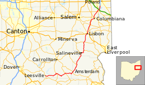
State Route 164 (SR 164) is a state highway passing through four counties in east-central Ohio. The route runs in a general southwest to northeast fashion, and is signed north–south accordingly. The southern terminus is at an intersection with State Route 212 1-mile (1.6 km) south of Leesville, and the northern terminus is at Interstate 680 and Western Reserve Road on the Beaver and Boardman township boundary between North Lima and Boardman. The southern part of the route serves more rural areas while it makes its way through larger villages and cities toward its northern end.
History
SR 164 was commissioned in 1923, routed from Salineville to Youngstown.[2][3] The highway was reroute from North Lima to Youngstown along previous Route 7, in 1926.[4][5] In 1937 the route was extended south to SR 43 in Amsterdam.[6][7] The route was extended southeast to the current intersection at SR 212, south of Leesville, in 1938.[7][8] Between 1977 and 1979 the northern terminus was relocated to the current interchange with I–680.[9][10]
Major intersections
| County | Location | mi[1] | km | Destinations | Notes |
|---|---|---|---|---|---|
| Carroll | Leesville | 0.00 | 0.00 | Southern terminus of SR 164 | |
| Perry Township | 7.27 | 11.70 | |||
| Loudon Township | 13.71 | 22.06 | Southern end of SR 9 concurrency | ||
| 13.77 | 22.16 | Northern end of SR 9 concurrency | |||
| Jefferson | Amsterdam | 18.84 | 30.32 | Southern end of SR 43 concurrency | |
| 18.96 | 30.51 | Northern end of SR 43 concurrency | |||
| Bergholz | 24.02 | 38.66 | Southern terminus of SR 524 | ||
| Columbiana | Salineville | 31.93 | 51.39 | Southern end of SR 39 concurrency | |
| Washington Township | 34.46 | 55.46 | Northern end of SR 39 concurrency | ||
| Wayne Township | 39.38 | 63.38 | Western end of SR 518 concurrency | ||
| 39.79 | 64.04 | Eastern end of SR 518 concurrency | |||
| Lisbon | 44.90 | 72.26 | Southern end of SR 45 concurrency; western terminus of SR 154; Southern terminus of SR 517; southern end of SR 517 concurrency | ||
| 45.25 | 72.82 | Northern end of SR 45 concurrency | |||
| 45.63 | 73.43 | Northern end of SR 517 concurrency | |||
| Fairfield Township | 50.29 | 80.93 | |||
| 53.21 | 85.63 | western end of SR 344 concurrency | |||
| Columbiana | 54.98 | 88.48 | Eastern end of SR 344 concurrency; eastern terminus of SR 344 | ||
| Columbiana–Mahoning county line | 55.78 | 89.77 | |||
| Mahoning | North Lima | 59.37 | 95.55 | ||
| 59.75 | 96.16 | ||||
| Beaver Township | 60.77 | 97.80 | Southern end of SR 626 concurrency | ||
| 60.89 | 97.99 | Northern end of SR 626 concurrency | |||
| 63.57 | 102.31 | Northern terminus of SR 164 | |||
1.000 mi = 1.609 km; 1.000 km = 0.621 mi
| |||||
References
- 1 2 Ohio Department of Transportation. "Technical Services Straight Line Diagrams". Retrieved April 30, 2010.
- 1 2 Ohio Department of Highways and Public Works (April 1922). Map of Ohio State Highways (MrSID) (Map). Columbus: Ohio Department of Highways and Public Works. Retrieved September 24, 2013.
- 1 2 Ohio Department of Highways and Public Works (July 1923). Map of Ohio Showing State Routes (MrSID) (Map). 1:760,320. Columbus: Ohio Department of Highways and Public Works. Retrieved September 24, 2013.
- ↑ Ohio Department of Highways and Public Works (August 1925). Map of Ohio Showing State Routes (MrSID) (Map). 1:760,320. Columbus: Ohio Department of Highways and Public Works. OCLC 5673562. Retrieved September 24, 2013.
- ↑ Ohio Department of Highways and Public Works (August 1, 1926). Map of Ohio Showing State Routes (MrSID) (Map). 1:760,320. Columbus: Ohio Department of Highways and Public Works. OCLC 5673562. Retrieved September 24, 2013.
- ↑ Ohio Department of Highways (1936). Official Highway Map of Ohio (MrSID) (Map). 1:760,320. Columbus: Ohio Department of Highways. OCLC 5673562. Retrieved September 24, 2013.
- 1 2 Ohio Department of Highways (1937). Official Highway Map of Ohio (MrSID) (Map). 1:633,600. Columbus: Ohio Department of Highways. OCLC 5673562, 16960304. Retrieved September 24, 2013.
- ↑ Ohio Department of Highways (1938). Official Highway Map of Ohio (MrSID) (Map). 1:633,600. Columbus: Ohio Department of Highways. OCLC 5673562, 7453129. Retrieved September 24, 2013.
- ↑ Ohio Department of Transportation (1977). Official Highway Map of Ohio (MrSID) (Map). 1:554,400. Columbus: Ohio Department of Transportation. OCLC 5673562, 49061100. Retrieved September 24, 2013.
- ↑ Ohio Department of Transportation (1979). Official Highway Map of Ohio (MrSID) (Map). 1:554,400. Columbus: Ohio Department of Transportation. OCLC 5673562, 7302607. Retrieved September 24, 2013.