| [3] |
Name on the Register[4] |
Image |
Date listed[5] |
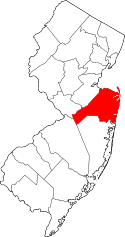
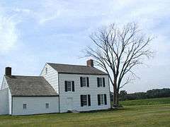
Location |
City or town |
Description |
|---|
| 1 |
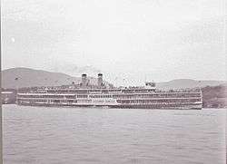
PS Alexander Hamilton (steamship) |
|
000000001977-03-25-0000March 25, 1977
(#77000887) |
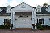
Off NJ 36
40°25′19″N 74°02′06″W / 40.421944°N 74.035°W / 40.421944; -74.035 (PS Alexander Hamilton (steamship)) |
Atlantic Highlands |
|
| 2 |
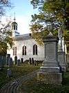
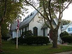
All Saints' Memorial Church Complex |
|
000000001974-02-15-0000February 15, 1974
(#74001179) |
Navesink Ave. and Locust Rd.
40°23′53″N 74°01′13″W / 40.398133°N 74.020275°W / 40.398133; -74.020275 (All Saints' Memorial Church Complex) |
Navesink |
|
| 3 |
Allaire Village |
|
000000001974-01-11-0000January 11, 1974
(#74001174) |
3 miles (4.8 km) southeast of Farmingdale on NJ 524
40°09′31″N 74°07′44″W / 40.158611°N 74.128889°W / 40.158611; -74.128889 (Allaire Village) |
Farmingdale |
|
| 4 |
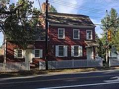
Allen House |
|
000000001974-05-08-0000May 8, 1974
(#74001180) |
Broad St. and Sycamore Ave.
40°19′26″N 74°03′44″W / 40.323889°N 74.062222°W / 40.323889; -74.062222 (Allen House) |
Shrewsbury |
|
| 5 |
Allenhurst Railroad Station |
|
000000001980-09-17-0000September 17, 1980
(#80002504) |
Main St.
40°14′14″N 74°00′25″W / 40.237222°N 74.006944°W / 40.237222; -74.006944 (Allenhurst Railroad Station) |
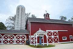
Allenhurst |
|
| 6 |
Allenhurst Residential Historic District |
|
000000002010-06-18-0000June 18, 2010
(#10000353) |
Roughly bounded by the Atlantic Ocean, Main St., Cedar Ave., Hume St., and Elberon Ave.
40°14′10″N 74°00′02″W / 40.236222°N 74.000692°W / 40.236222; -74.000692 (Allenhurst Residential Historic District) |
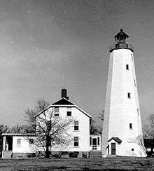
Allenhurst |
|
| 7 |
Allentown Historic District |
|
000000001982-06-14-0000June 14, 1982
(#82003284) |
N. and S. Main Sts.
40°10′36″N 74°35′14″W / 40.176667°N 74.587222°W / 40.176667; -74.587222 (Allentown Historic District) |
Allentown |
|
| 8 |
Allentown Mill |
|
000000001978-02-14-0000February 14, 1978
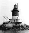
(#78001774) |
42 S. Main St.
40°10′34″N 74°35′13″W / 40.176111°N 74.586944°W / 40.176111; -74.586944 (Allentown Mill) |
Allentown |
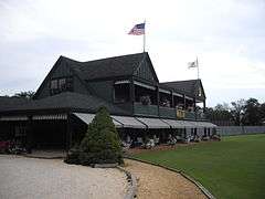
|
| 9 |
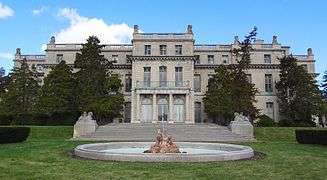
Allgor-Barkalow Homestead |
|
000000001984-06-21-0000June 21, 1984
(#84002748) |
New Bedford Rd.
40°10′30″N 74°03′52″W / 40.175°N 74.064444°W / 40.175; -74.064444 (Allgor-Barkalow Homestead) |
Wall Township |
|
| 10 |
Arburtus Cottage |
Upload image |
000000002015-08-18-0000August 18, 2015
(#15000003) |
508 4th Ave.
40°13′25″N 74°00′25″W / 40.223633°N 74.006903°W / 40.223633; -74.006903 (Arburtus Cottage) |
Asbury Park |
|
| 11 |
Asbury Park Commercial Historic District |
|
000000002014-09-30-0000September 30, 2014
(#14000536) |
Roughly bounded by 500, 600, 700 blks., of Bond St., Cookman & Mattison Aves. between Lake & Bangs Aves.
40°12′59″N 74°00′43″W / 40.2164°N 74.0119°W / 40.2164; -74.0119 (Asbury Park Commercial Historic District) |
Asbury Park |
|
| 12 |
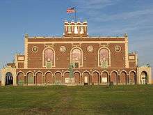
Asbury Park Convention Hall |
|
000000001979-03-02-0000March 2, 1979
(#79001512) |
Ocean Ave.
40°13′22″N 73°59′56″W / 40.222778°N 73.998889°W / 40.222778; -73.998889 (Asbury Park Convention Hall) |
Asbury Park |
|
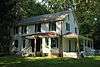
| 13 |
Audenried Cottage |
|
000000001991-03-08-0000March 8, 1991
(#91000117) |
21 Tuttle Ave.
40°09′31″N 74°01′21″W / 40.158611°N 74.0225°W / 40.158611; -74.0225 (Audenried Cottage) |
Spring Lake |
Now the Normandy Inn; part of the Spring Lake, NJ as a Coastal Resort Multiple Property Submission (MPS)
|
| 14 |
Bradley Beach Free Public Library |
|
000000002013-12-24-0000December 24, 2013
(#13000976) |
511 4th Ave.
40°12′01″N 74°00′58″W / 40.200379°N 74.016244°W / 40.200379; -74.016244 (Bradley Beach Free Public Library) |
Bradley Beach |
|
| 15 |
Bradley Beach Station |
|
000000001984-06-22-0000June 22, 1984
(#84002749) |
Between LaReine and Brimley Aves.
40°12′13″N 74°01′09″W / 40.203611°N 74.019167°W / 40.203611; -74.019167 (Bradley Beach Station) |
Bradley Beach |
part of the Operating Passenger Railroad Stations Thematic Resource (TR)
|
| 16 |
Brielle Road Bridge over the Glimmer Glass |
|
000000002008-04-25-0000April 25, 2008
(#08000336) |
Brielle Rd. over The Glimmer Glass
40°06′43″N 74°02′45″W / 40.111886°N 74.04577°W / 40.111886; -74.04577 (Brielle Road Bridge over the Glimmer Glass) |
Brielle and Manasquan |
|
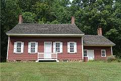
| 17 |
Maj. John Burrowes Mansion |
|
000000001972-09-29-0000September 29, 1972
(#72000803) |
94 Main St.
40°25′00″N 74°13′46″W / 40.416667°N 74.229444°W / 40.416667; -74.229444 (Maj. John Burrowes Mansion) |
Matawan |
|
| 18 |
Camp Evans Historic District |
|
000000002002-03-26-0000March 26, 2002
(#02000274) |
2201 Marconi Rd. (Wall Township)
• Boundary increase and decrease (listed 000000002012-08-21-0000August 21, 2012, refnum 12000076): 2201 Marconi Rd. (Wall Township)
40°11′06″N 74°03′28″W / 40.185°N 74.057778°W / 40.185; -74.057778 (Camp Evans Historic District) |
Wall Township |
|
| 19 |
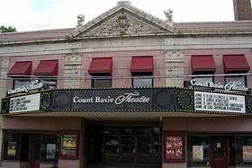
The Carlton Theatre |
|
000000002009-12-18-0000December 18, 2009
(#09001100) |
99 Monmouth St.
40°20′56″N 74°04′13″W / 40.348836°N 74.070364°W / 40.348836; -74.070364 (The Carlton Theatre) |
Red Bank Borough |
Also known as Count Basie Theatre
|
| 20 |
Chauncy Jerome Jr. Shipwreck Site |
|
000000001996-03-01-0000March 1, 1996
(#96000205) |
Address Restricted
|
Long Branch City |
|
| 21 |
Christ Church |
|
000000001971-11-12-0000November 12, 1971
(#71000511) |
92 Kings Hwy.
40°23′38″N 74°07′05″W / 40.393889°N 74.118056°W / 40.393889; -74.118056 (Christ Church) |
Middletown |
|
| 22 |
Christ Church (Episcopal), Shrewsbury |
|
000000001995-10-25-0000October 25, 1995
(#95001184) |
Jct. of Broad St. and Sycamore Ave.
40°19′25″N 74°03′42″W / 40.323611°N 74.061667°W / 40.323611; -74.061667 (Christ Church (Episcopal), Shrewsbury) |
Shrewsbury |
|
| 23 |
Church of the Presidents |
|
000000001976-11-07-0000November 7, 1976
(#76001169) |
1260 Ocean Ave.
40°15′48″N 73°59′27″W / 40.263333°N 73.990833°W / 40.263333; -73.990833 (Church of the Presidents) |
Long Branch |
|
| 24 |
Clarksburg Methodist Episcopal Church |
|
000000001999-02-05-0000February 5, 1999
(#99000084) |
512 Cty Rd. 524
40°11′29″N 74°27′05″W / 40.191389°N 74.451389°W / 40.191389; -74.451389 (Clarksburg Methodist Episcopal Church) |
Millstone Township |
|
| 25 |
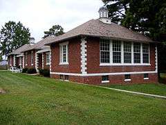
Clarksburg School |
|
000000001999-11-12-0000November 12, 1999
(#99001316) |
524 Stagecoach Rd. (Millstone Township)
40°11′28″N 74°26′33″W / 40.191111°N 74.4425°W / 40.191111; -74.4425 (Clarksburg School) |
Clarksburg |
|
| 26 |
Dr. Robert W. Cooke Medical Office |
|
000000002011-01-18-0000January 18, 2011
(#10001145) |
67 McCampbell Rd.
40°20′45″N 74°10′11″W / 40.345833°N 74.169722°W / 40.345833; -74.169722 (Dr. Robert W. Cooke Medical Office) |
Holmdel |
New listing; refnum 10001145
|
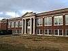
| 27 |
Court Street School |
|
000000001995-08-04-0000August 4, 1995
(#95001003) |
Jct. of Court St. and Holmes Terr.
40°15′58″N 74°17′01″W / 40.266111°N 74.283611°W / 40.266111; -74.283611 (Court Street School) |
Freehold |
|
| 28 |
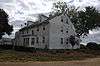
Coward-Smith House |
|
000000001989-07-06-0000July 6, 1989
(#89000804) |
Burlington Path Rd.
40°08′32″N 74°28′28″W / 40.142222°N 74.474444°W / 40.142222; -74.474444 (Coward-Smith House) |
Upper Freehold |
|
| 29 |
Coward-Hendrickson House |
|
000000001985-03-21-0000March 21, 1985
(#85000594) |
Address Restricted
|
Cream Ridge |
|
| 30 |
First Presbyterian Church of Rumson |
|
000000002010-03-03-0000March 3, 2010
(#09000132) |
4 E. River Rd.
40°22′34″N 74°00′35″W / 40.376239°N 74.009858°W / 40.376239; -74.009858 (First Presbyterian Church of Rumson) |
Rumson |
New listing; refnum 09000132
|
| 31 |
Frederic A. Duggan First Aid and Emergency Squad Building |
|
000000001998-09-18-0000September 18, 1998
(#98001177) |
311 Washington Ave.
40°09′19″N 74°01′45″W / 40.155278°N 74.029167°W / 40.155278; -74.029167 (Frederic A. Duggan First Aid and Emergency Squad Building) |
Spring Lake |
|
| 32 |
Fisk Chapel |
|
000000001975-10-29-0000October 29, 1975
(#75001146) |
Cedar Ave.
40°21′38″N 74°02′28″W / 40.360556°N 74.041111°W / 40.360556; -74.041111 (Fisk Chapel) |
Fair Haven |
|
| 33 |
Fort Hancock and the Sandy Hook Proving Ground Historic District |
|
000000001980-04-24-0000April 24, 1980
(#80002505) |
NJ 36
40°26′41″N 73°59′44″W / 40.444722°N 73.995556°W / 40.444722; -73.995556 (Fort Hancock and the Sandy Hook Proving Ground Historic District) |
Sandy Hook |
|
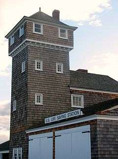
| 34 |
Fort Hancock U.S. Life Saving Station |
|
000000001981-11-30-0000November 30, 1981
(#81000080) |
North of Highlands on Sandy Hook
40°25′35″N 73°59′05″W / 40.426389°N 73.984722°W / 40.426389; -73.984722 (Fort Hancock U.S. Life Saving Station) |
Highlands |
|
| 35 |
Fort Monmouth Historic District |
|
000000002014-03-12-0000March 12, 2014
(#13000764) |
Oceanport Ave.
40°18′50″N 74°02′42″W / 40.314°N 74.045°W / 40.314; -74.045 (Fort Monmouth Historic District) |
Oceanport |
|
| 36 |
T. Thomas Fortune House |
|
000000001976-12-08-0000December 8, 1976
(#76001171) |
94 W. Bergen Pl.
40°20′29″N 74°04′26″W / 40.341389°N 74.073889°W / 40.341389; -74.073889 (T. Thomas Fortune House) |
Red Bank |
|
| 37 |
Gregory Primary School |
|
000000002012-10-24-0000October 24, 2012
(#12000880) |
157 N. 7th Ave.
40°18′30″N 73°59′47″W / 40.308298°N 73.99631°W / 40.308298; -73.99631 (Gregory Primary School) |
Long Branch |
|
| 38 |
Grover House |
|
000000002002-10-10-0000October 10, 2002
(#02001121) |
940 W. Front St.
40°20′41″N 74°06′16″W / 40.344722°N 74.104444°W / 40.344722; -74.104444 (Grover House) |
Middletown |
|
| 39 |
Murry Guggenheim House |
|
000000001978-03-28-0000March 28, 1978
(#78001778) |
Cedar and Norwood Aves.
40°16′56″N 74°00′12″W / 40.282222°N 74.003333°W / 40.282222; -74.003333 (Murry Guggenheim House) |
West Long Branch |
Also known as Guggenheim Library, at Monmouth University
|
| 40 |
Hankinson-Moreau-Covenhoven House |
|
000000001974-05-01-0000May 1, 1974
(#74001175) |
150 W. Main St.
40°15′07″N 74°17′19″W / 40.251944°N 74.288611°W / 40.251944; -74.288611 (Hankinson-Moreau-Covenhoven House) |
Freehold |
|
| 41 |
Holmdel Dutch Reformed Church |
|
000000001980-10-22-0000October 22, 1980
(#80002506) |
41 Main St.
40°20′43″N 74°11′04″W / 40.345278°N 74.184444°W / 40.345278; -74.184444 (Holmdel Dutch Reformed Church) |
Holmdel |
|
| 42 |
Holmes-Hendrickson House |
|
000000001978-04-26-0000April 26, 1978
(#78001776) |
North of Holmdel
40°22′20″N 74°11′09″W / 40.372222°N 74.185833°W / 40.372222; -74.185833 (Holmes-Hendrickson House) |
Holmdel |
|
| 43 |
Holy Trinity Episcopal Church |
|
000000001991-03-08-0000March 8, 1991
(#91000116) |
Jct. of Monmouth and Third Aves.
40°08′46″N 74°01′52″W / 40.146111°N 74.031111°W / 40.146111; -74.031111 (Holy Trinity Episcopal Church) |
Spring Lake |
part of the Spring Lake, NJ as a Coastal Resort MPS
|
| 44 |
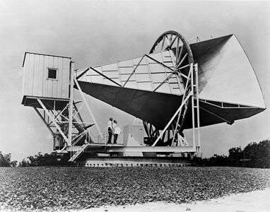
Horn Antenna |
|
000000001989-12-20-0000December 20, 1989
(#89002457) |
Off Garden State Parkway in Crawford Hill Facility
40°23′29″N 74°11′07″W / 40.391389°N 74.185278°W / 40.391389; -74.185278 (Horn Antenna) |
Holmdel |
|
| 45 |
House at 364 Cedar Avenue |
|
000000001979-11-01-0000November 1, 1979
(#79001514) |
364 Cedar Avenue
40°16′52″N 74°00′06″W / 40.281111°N 74.001667°W / 40.281111; -74.001667 (House at 364 Cedar Avenue) |
Long Branch |
Also known as Lauren K. Woods Theater, at Monmouth University
|
| 46 |
Imlaystown Historic District |
|
000000001985-01-03-0000January 3, 1985
(#85000032) |
Roughly Imlaystown-Davis Station Rd., and Imlaystown-Red Valley Rd.
40°09′50″N 74°30′41″W / 40.163889°N 74.511389°W / 40.163889; -74.511389 (Imlaystown Historic District) |
Upper Freehold Township |
|
| 47 |
Jersey Homesteads Historic District |
|
000000001983-12-05-0000December 5, 1983
(#83004053) |
All that area within the corporate boundaries of the Borough of Roosevelt
40°13′17″N 74°28′26″W / 40.221389°N 74.473889°W / 40.221389; -74.473889 (Jersey Homesteads Historic District) |
Roosevelt |
|
| 48 |
Kovenhoven |
|
000000001974-04-26-0000April 26, 1974
(#74001176) |
North of Holmdel off NJ 34
40°21′56″N 74°11′43″W / 40.365556°N 74.195278°W / 40.365556; -74.195278 (Kovenhoven) |
Holmdel |
|
| 49 |
Lauriston |
|
000000002002-03-08-0000March 8, 2002
(#02000134) |
Address Restricted
|
Rumson |
|
| 50 |
Little Silver Station |
|
000000001984-06-22-0000June 22, 1984
(#84002754) |
Sycamore and Branch Aves.
40°19′35″N 74°02′28″W / 40.326389°N 74.041111°W / 40.326389; -74.041111 (Little Silver Station) |
Little Silver |
part of the Operating Passenger Railroad Stations TR
|
| 51 |
Longstreet Farm |
|
000000001979-11-29-0000November 29, 1979
(#79003255) |
North of Holmdel on Longstreet Rd.
40°22′08″N 74°11′02″W / 40.368889°N 74.183889°W / 40.368889; -74.183889 (Longstreet Farm) |
Holmdel |
|
| 52 |
MacGregor-Tallman House |
|
000000001985-09-05-0000September 5, 1985
(#85002003) |
407 Monmouth Rd.
40°16′52″N 74°01′09″W / 40.281111°N 74.019167°W / 40.281111; -74.019167 (MacGregor-Tallman House) |
West Long Branch |
|
| 53 |
Martin Maloney Cottage |
|
000000001992-10-26-0000October 26, 1992
(#91000115) |
101 Morris Ave.
40°09′05″N 74°01′29″W / 40.151389°N 74.024722°W / 40.151389; -74.024722 (Martin Maloney Cottage) |
Spring Lake |
part of the Spring Lake, NJ as a Coastal Resort MPS
|
| 54 |
Manasquan Friends Meetinghouse and Burying Ground |
|
000000001992-07-22-0000July 22, 1992
(#91000902) |
NJ 35 at Manasquan Cir., Wall Township
40°07′58″N 74°03′53″W / 40.132778°N 74.064722°W / 40.132778; -74.064722 (Manasquan Friends Meetinghouse and Burying Ground) |
Manasquan |
|
| 55 |
Matawan Station |
|
000000001984-06-22-0000June 22, 1984
(#84002756) |
Between Main and Atlantic Aves.
40°25′12″N 74°13′27″W / 40.42°N 74.224167°W / 40.42; -74.224167 (Matawan Station) |
Matawan |
part of the Operating Passenger Railroad Stations TR
|
| 56 |
Merino Hill House and Farm |
|
000000001988-02-11-0000February 11, 1988
(#87002561) |
Allentown-Clarksburg Rd., CR 524
40°11′08″N 74°30′06″W / 40.185556°N 74.501667°W / 40.185556; -74.501667 (Merino Hill House and Farm) |
Wrightsville |
|
| 57 |
Middletown Village Historic District |
|
000000001974-05-03-0000May 3, 1974
(#74001177) |
Irregular pattern--both sides of Kings Highway, south and west of NJ 35
40°23′36″N 74°06′47″W / 40.393333°N 74.113056°W / 40.393333; -74.113056 (Middletown Village Historic District) |
Middletown |
|
| 58 |
Monmouth Battlefield |
|
000000001966-10-15-0000October 15, 1966
(#66000467) |
Northwest of Freehold on NJ 522, west of Rte. 9
40°16′23″N 74°18′50″W / 40.273056°N 74.313889°W / 40.273056; -74.313889 (Monmouth Battlefield) |
Freehold |
|
| 59 |
Monmouth Boat Club |
|
000000001994-08-16-0000August 16, 1994
(#94000857) |
Union St. east of Boat Club Ct.
40°21′12″N 74°04′01″W / 40.353333°N 74.066944°W / 40.353333; -74.066944 (Monmouth Boat Club) |
Red Bank |
|
| 60 |
Navesink Historic District |
|
000000001975-09-05-0000September 5, 1975
(#75001148) |
Roughly triangular area including both sides of Monmouth Ave. and Locust Ave. to junction with Hillside and Grand Aves.
40°24′02″N 74°02′03″W / 40.400556°N 74.034167°W / 40.400556; -74.034167 (Navesink Historic District) |
Navesink |
|
| 61 |
Navesink Light Station |
|
000000002006-02-17-0000February 17, 2006
(#06000237) |
100 Government-Lighthouse Rd.
40°23′46″N 73°59′09″W / 40.396222°N 73.985778°W / 40.396222; -73.985778 (Navesink Light Station) |
Highlands |
|
| 62 |
Navesink Military Reservation Historic District |
|
000000002015-10-13-0000October 13, 2015
(#15000011) |
Grand Tour Road and Portland Road, Hartshorne Woods Park
40°23′26″N 73°59′20″W / 40.390556°N 73.988889°W / 40.390556; -73.988889 (Navesink Military Reservation Historic District) |
Middletown Township |
|
| 63 |
North Long Branch School-Primary No. 3 |
|
000000001999-07-28-0000July 28, 1999
(#99000906) |
469 Church St.
40°19′15″N 73°58′44″W / 40.320833°N 73.978889°W / 40.320833; -73.978889 (North Long Branch School-Primary No. 3) |
Long Branch |
|
| 64 |
Ocean Grove Camp Meeting Association District |
|
000000001976-04-12-0000April 12, 1976
(#76001170) |
Bounded by Fletcher Lake, NJ 71, Lake Wesley, and the Ocean
40°12′34″N 74°00′47″W / 40.209444°N 74.013056°W / 40.209444; -74.013056 (Ocean Grove Camp Meeting Association District) |
Ocean Grove |
|
| 65 |
Old Kentuck |
|
000000001973-11-06-0000November 6, 1973
(#73001118) |
Northwest of Holmdel off NJ 34 on Pleasant Valley Rd.
40°21′56″N 74°13′14″W / 40.365556°N 74.220556°W / 40.365556; -74.220556 (Old Kentuck) |
Holmdel |
|
| 66 |
Old Mill at Tinton Falls |
|
000000001973-04-24-0000April 24, 1973
(#73001119) |
1205 Sycamore Ave.
40°18′16″N 74°06′03″W / 40.304444°N 74.100833°W / 40.304444; -74.100833 (Old Mill at Tinton Falls) |
Tinton Falls |
|
| 67 |
Old Scots Burying Ground |
|
000000002001-08-15-0000August 15, 2001
(#01000841) |
Gordon's Corner Rd.
40°20′23″N 74°15′35″W / 40.339722°N 74.259722°W / 40.339722; -74.259722 (Old Scots Burying Ground) |
Marlboro |
|
| 68 |
Palace Amusements |
|
000000002000-11-22-0000November 22, 2000
(#00001406) |
201-207 Lake Ave.
40°13′04″N 74°00′13″W / 40.217778°N 74.003611°W / 40.217778; -74.003611 (Palace Amusements) |
Asbury Park |
Demolished in 2004
|
| 69 |
Parker Homestead |
|
000000002011-12-28-0000December 28, 2011
(#11000966) |
235 Rumson Rd.
40°20′36″N 74°02′26″W / 40.343358°N 74.040564°W / 40.343358; -74.040564 (Parker Homestead) |
Little Silver |
|
| 70 |
Probasco-Dittner Farmstead |
|
000000002006-02-01-0000February 1, 2006
(#05001564) |
61 Bucks Mill Rd.
40°17′15″N 74°12′14″W / 40.2875°N 74.203889°W / 40.2875; -74.203889 (Probasco-Dittner Farmstead) |
Colts Neck |
|
| 71 |
Portland Place |
|
000000002012-12-12-0000December 12, 2012
(#12001033) |
220 Hartshorne Rd.
40°23′25″N 74°00′21″W / 40.390293°N 74.005732°W / 40.390293; -74.005732 (Portland Place) |
Middletown Township |
|
| 72 |
Anthony Reckless Estate |
|
000000001982-06-03-0000June 3, 1982
(#82003286) |
164 Broad St.
40°20′47″N 74°03′58″W / 40.346389°N 74.066111°W / 40.346389; -74.066111 (Anthony Reckless Estate) |
Red Bank |
|
| 73 |
Red Bank Passenger Station |
|
000000001976-05-28-0000May 28, 1976
(#76001172) |
Ridge and Monmouth Sts.
40°20′52″N 74°04′30″W / 40.347778°N 74.075°W / 40.347778; -74.075 (Red Bank Passenger Station) |
Red Bank |
|
| 74 |
River Street School |
|
000000001995-04-14-0000April 14, 1995
(#95000410) |
60 River St.
40°20′35″N 74°04′36″W / 40.343056°N 74.076667°W / 40.343056; -74.076667 (River Street School) |
Red Bank |
|
| 75 |
Romer Shoal Light Station |
|
000000002007-01-24-0000January 24, 2007
(#06001304) |
In Lower New York Bay, 3.8 miles (6.1 km) north of Sandy Hook
40°30′46″N 74°00′50″W / 40.512778°N 74.013889°W / 40.512778; -74.013889 (Romer Shoal Light Station) |
Highlands Borough |
part of the Light Stations of the United States MPS
|
| 76 |
Salter's Mill |
|
000000001980-09-29-0000September 29, 1980
(#80002507) |
Imlaystown-Davis Station Rd.
40°09′54″N 74°30′51″W / 40.165°N 74.514167°W / 40.165; -74.514167 (Salter's Mill) |
Imlaystown |
|
| 77 |
Sandy Hook Archeological Site |
|
000000001998-06-26-0000June 26, 1998
(#98000704) |
Gateway National Recreation Area, Address Restricted
|
Highlands |
|
| 78 |
Sandy Hook Light |
|
000000001966-10-15-0000October 15, 1966
(#66000468) |
Fort Hancock Military Reservation
40°27′42″N 74°00′09″W / 40.461667°N 74.0025°W / 40.461667; -74.0025 (Sandy Hook Light) |
Sandy Hook |
|
| 79 |
Seabright Lawn Tennis and Cricket Club |
|
000000001991-07-09-0000July 9, 1991
(#91000883) |
Jct. of Rumson Rd. and Tennis Court Ln.
40°21′59″N 73°59′01″W / 40.366389°N 73.983611°W / 40.366389; -73.983611 (Seabright Lawn Tennis and Cricket Club) |
Rumson |
|
| 80 |
Seabrook-Wilson House |
|
000000001974-10-29-0000October 29, 1974
(#74001178) |
119 Port Monmouth Rd.
40°26′21″N 74°05′35″W / 40.439167°N 74.093056°W / 40.439167; -74.093056 (Seabrook-Wilson House) |
Middletown |
|
| 81 |
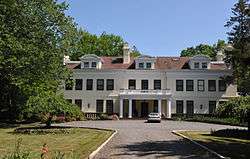
Shadow Lawn |
|
000000001978-03-28-0000March 28, 1978
(#78001780) |
Cedar and Norwood Aves.
40°16′46″N 74°00′19″W / 40.279444°N 74.005278°W / 40.279444; -74.005278 (Shadow Lawn) |
West Long Branch |
Also known as Woodrow Wilson Hall, at Monmouth University
|
| 82 |
Shrewsbury Historic District |
|
000000001978-07-17-0000July 17, 1978
(#78001779) |
Broad and Sycamore Sts.
40°19′23″N 74°03′49″W / 40.323056°N 74.063611°W / 40.323056; -74.063611 (Shrewsbury Historic District) |
Shrewsbury |
|
| 83 |
Shrewsbury Township Hall |
|
000000001980-12-08-0000December 8, 1980
(#80002508) |
51 Monmouth St.
40°20′57″N 74°04′06″W / 40.349167°N 74.068333°W / 40.349167; -74.068333 (Shrewsbury Township Hall) |
Red Bank |
|
| 84 |
Squan Beach Life-Saving Station #9 |
|
000000002008-03-05-0000March 5, 2008
(#08000135) |
Ocean & 2nd Aves.
40°07′03″N 74°02′02″W / 40.1175°N 74.033889°W / 40.1175; -74.033889 (Squan Beach Life-Saving Station #9) |
Manasquan |
|
| 85 |
St. George's-by-the-River Episcopal Church |
|
000000002007-02-13-0000February 13, 2007
(#07000045) |
7 Lincoln Ave.
40°21′48″N 73°58′43″W / 40.363333°N 73.978611°W / 40.363333; -73.978611 (St. George's-by-the-River Episcopal Church) |
Rumson |
|
| 86 |
St. James Memorial Church of Eatontown |
|
000000001978-02-17-0000February 17, 1978
(#78001775) |
69 Broad St.
40°18′22″N 74°03′26″W / 40.306111°N 74.057222°W / 40.306111; -74.057222 (St. James Memorial Church of Eatontown) |
Eatontown |
|
| 87 |
St. John's Episcopal Church |
|
000000001990-12-27-0000December 27, 1990
(#90001374) |
Little Silver Point Rd.
40°20′02″N 74°01′58″W / 40.333889°N 74.032778°W / 40.333889; -74.032778 (St. John's Episcopal Church) |
Little Silver |
|
| 88 |
St. Peter's Episcopal Church |
|
000000001998-03-19-0000March 19, 1998
(#98000256) |
31 Throckmorton St.
40°15′34″N 74°16′34″W / 40.259444°N 74.276111°W / 40.259444; -74.276111 (St. Peter's Episcopal Church) |
Freehold Borough |
|
| 89 |
Steinbach-Cookman Building |
|
000000001982-07-08-0000July 8, 1982
(#82003285) |
Cookman Ave.
40°12′59″N 74°00′37″W / 40.216389°N 74.010278°W / 40.216389; -74.010278 (Steinbach-Cookman Building) |
Asbury Park |
|
| 90 |
George Taylor House |
|
000000001994-04-29-0000April 29, 1994
(#94000392) |
74 Broadway
40°16′03″N 74°16′02″W / 40.2675°N 74.267222°W / 40.2675; -74.267222 (George Taylor House) |
Freehold Borough |
|
| 91 |
Tinton Falls Historic District |
|
000000001977-11-10-0000November 10, 1977
(#77000888) |
Irregular pattern along Tinton and Sycamore Aves.
40°18′18″N 74°05′57″W / 40.305°N 74.099167°W / 40.305; -74.099167 (Tinton Falls Historic District) |
Tinton Falls |
|
| 92 |
Twin Lights |
|
000000001970-12-02-0000December 2, 1970
(#70000389) |
South of NJ 36 on a promontory between the Navesink River and Sandy Hook Bay
40°23′48″N 73°59′11″W / 40.396667°N 73.986389°W / 40.396667; -73.986389 (Twin Lights) |
Highlands |
|
| 93 |
The Towers |
|
000000002012-08-20-0000August 20, 2012
(#12000529) |
27 Prospect Circle
40°24′44″N 74°02′01″W / 40.412173°N 74.033487°W / 40.412173; -74.033487 (The Towers) |
Atlantic Highlands |
|
| 94 |
Trinity Church |
|
000000002014-08-06-0000August 6, 2014
(#14000465) |
503 Asbury Ave.
40°13′11″N 74°00′29″W / 40.2197°N 74.0081°W / 40.2197; -74.0081 (Trinity Church) |
Asbury Park |
|
| 95 |
Union Schoolhouse |
|
000000001976-06-23-0000June 23, 1976
(#76001173) |
West of Red Bank on Middletown-Lincroft Rd.
40°21′57″N 74°07′14″W / 40.365833°N 74.120556°W / 40.365833; -74.120556 (Union Schoolhouse) |
Red Bank |
|
| 96 |
Upper Freehold Baptist Meeting |
|
000000001975-04-21-0000April 21, 1975
(#75001147) |
East of Imlaystown on Red Valley Rd.
40°10′08″N 74°28′28″W / 40.168889°N 74.474444°W / 40.168889; -74.474444 (Upper Freehold Baptist Meeting) |
Imlaystown |
|
| 97 |
Upper Meeting House of the Baptist Church of Middletown |
|
000000001990-12-07-0000December 7, 1990
(#87002573) |
40 Main St.
40°20′41″N 74°11′11″W / 40.344722°N 74.186389°W / 40.344722; -74.186389 (Upper Meeting House of the Baptist Church of Middletown) |
Holmdel |
|
| 98 |
Village Inn |
|
000000001972-11-13-0000November 13, 1972
(#72000802) |
Water and Main Sts.
40°17′50″N 74°21′34″W / 40.297222°N 74.359444°W / 40.297222; -74.359444 (Village Inn) |
Englishtown |
|
| 99 |
Walker-Combs-Hartshorne Farmstead |
|
000000001990-10-04-0000October 4, 1990
(#90001474) |
189 Wemrock Rd.
40°14′51″N 74°18′22″W / 40.2475°N 74.306111°W / 40.2475; -74.306111 (Walker-Combs-Hartshorne Farmstead) |
Freehold |
|
| 100 |
Walnford |
|
000000001976-06-29-0000June 29, 1976
(#76001167) |
South of Allentown off CR 539
40°08′03″N 74°33′32″W / 40.134167°N 74.558889°W / 40.134167; -74.558889 (Walnford) |
Allentown |
|
| 101 |
Wardell House |
|
000000001974-07-24-0000July 24, 1974
(#74001181) |
419 Sycamore Ave.
40°19′22″N 74°03′46″W / 40.322778°N 74.062778°W / 40.322778; -74.062778 (Wardell House) |
Shrewsbury |
|
| 102 |
Water Witch Club Casino |
|
000000001990-08-13-0000August 13, 1990
(#90001219) |
Jct. of E. Twin Rd. and W. Twin Rd.
40°24′00″N 73°59′39″W / 40.4°N 73.994167°W / 40.4; -73.994167 (Water Witch Club Casino) |
Highlands |
|
| 103 |
Water Witch Club Historic District |
|
000000002004-03-12-0000March 12, 2004
(#04000147) |
Roughly bounded by NJ 36, Water Witch Dr., Sea View Terrace, Park Way, Windlass Path and Serpentine Dr.
40°24′02″N 73°59′49″W / 40.400556°N 73.996944°W / 40.400556; -73.996944 (Water Witch Club Historic District) |
Middletown Township |
|
| 104 |
Robert White House |
|
000000002012-03-07-0000March 7, 2012
(#12000077) |
20 South St.
40°20′45″N 74°03′43″W / 40.3458°N 74.061833°W / 40.3458; -74.061833 (Robert White House) |
Red Bank |
|
| 105 |
Winsor Building |
|
000000001979-09-13-0000September 13, 1979
(#79001513) |
400-420 Main St. and 715-131 Bangs Ave
40°13′02″N 74°00′42″W / 40.217222°N 74.011667°W / 40.217222; -74.011667 (Winsor Building) |
Asbury Park |
|
| 106 |
George Wurts Summer Home |
|
000000001989-12-28-0000December 28, 1989
(#89002162) |
306 Eighth Ave.
40°13′41″N 74°00′07″W / 40.228056°N 74.001944°W / 40.228056; -74.001944 (George Wurts Summer Home) |
Asbury Park |
|


.JPG)
.JPG)
.JPG)
.JPG)
.JPG)


.JPG)
.jpg)
.JPG)
.JPG)


.JPG)
.JPG)

.JPG)
.JPG)

.JPG)


.jpg)


.JPG)


.JPG)


.JPG)

.JPG)

.JPG)


.JPG)
.JPG)

.JPG)
.JPG)

.JPG)

.JPG)


.jpg)

.JPG)


.JPG)
.JPG)
.JPG)