National Register of Historic Places listings in Warren County, New Jersey
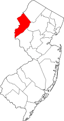
Location of Warren County in New Jersey
List of the National Register of Historic Places listings in Warren County, New Jersey
| Atlantic - Bergen - Burlington - Camden - Cape May - Cumberland - Essex - Gloucester - Hudson - Hunterdon - Mercer - Middlesex - Monmouth - Morris - Ocean - Passaic - Salem - Somerset - Sussex - Union - Warren |
This is intended to be a complete list of properties and districts listed on the National Register of Historic Places in Warren County, New Jersey. The locations of National Register properties and districts (at least for all showing latitude and longitude coordinates below) may be seen in an online map by clicking on "Map of all coordinates".[1]
- This National Park Service list is complete through NPS recent listings posted December 16, 2016.[2]
| [3] | Name on the Register[4] | Image | Date listed[5] | Location | City or town | Description |
|---|---|---|---|---|---|---|
| 1 | Allamuchy Freight House | 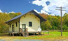 |
(#02001056) |
Rte. 612, 800 feet south of intersection with Long Bridge Road. 40°55′55″N 74°49′13″W / 40.932012°N 74.82021°W |
Allamuchy | |
| 2 | Jacob C. Allen House | 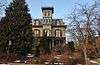 |
(#05000911) |
206 W. Moore St. 40°51′16″N 74°49′47″W / 40.854444°N 74.829722°W |
Hackettstown | |
| 3 | Asbury Historic District | 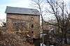 |
(#93000132) |
Roughly, NJ 643 from Maple Ave. to NJ 623 and adjacent parts of Maple, NJ 623 and Kitchen and School Sts. 40°41′53″N 75°00′50″W / 40.698056°N 75.013889°W |
Asbury | |
| 4 | Beattystown | 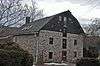 |
(#90001449) |
Jct. of NJ 57 and Kings Hwy., Mansfield Twnshp. 40°48′41″N 74°50′36″W / 40.811389°N 74.843333°W |
Beattystown | |
| 5 | Belvidere Historic District | 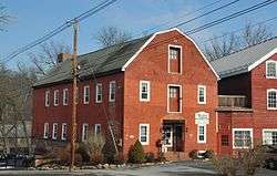 |
(#80002525) |
Off U.S. 46 40°49′45″N 75°04′37″W / 40.829167°N 75.076944°W |
Belvidere | |
| 6 | Blairstown Historic District | 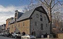 |
(#07000046) |
Main St., East Ave., Douglas St., Water St., Blair Place 40°59′00″N 74°57′35″W / 40.983284°N 74.95976°W |
Blairstown | |
| 7 | Bowerstown Historic District | 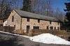 |
(#96000537) |
Roughly bounded by Bowerstown, Plane Hill, Lanning and Mine Hill Rds., Washington Township 40°46′22″N 74°59′48″W / 40.772778°N 74.996667°W |
Belvidere | |
| 8 | Centenary Collegiate Institute | 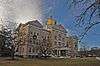 |
(#97000564) |
400 Jefferson St. 40°50′57″N 74°50′01″W / 40.849167°N 74.833611°W |
Hackettstown | |
| 9 | Delaware Historic District | 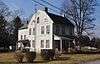 |
(#03000128) |
Ann, Clinton, Charles, and Valley STs., Delaware Rd., NJ 46 and Ferry Ln. 40°53′44″N 75°03′51″W / 40.895556°N 75.064167°W |
Knowlton Township | |
| 10 | Fairview Schoolhouse | 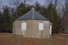 |
(#77000916) |
E of Columbia on Dean Rd. 40°55′16″N 75°00′54″W / 40.921111°N 75.015°W |
Columbia | |
| 11 | Finesville-Seigletown Historic District | 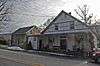 |
(#10000892) |
County Route 627; Mountain, Musconetcong, Mt. Joy and Bellis Rds. 40°36′26″N 75°10′17″W / 40.607222°N 75.171389°W |
Pohatcong Township | New listing; refnum 10000892 |
| 12 | Great Meadows Railroad Station | 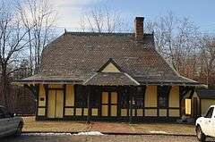 |
(#89000229) |
Cemetery Rd. 40°53′01″N 74°54′29″W / 40.883611°N 74.908056°W |
Great Meadows | |
| 13 | Hixson-Mixsell House | Upload image | (#14000204) |
157 Cty. Rd. 519 40°40′40″N 75°09′21″W / 40.6777439°N 75.1557355°W |
Pohatcong Township | |
| 14 | Hixson-Skinner Mill Complex | 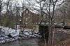 |
(#82001047) |
Still Valley Rd. 40°39′41″N 75°08′11″W / 40.661389°N 75.136389°W |
Phillipsburg | |
| 15 | Hope District | 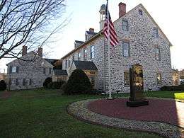 |
(#73001138) |
Roughly bounded by Beaver Brook, Washington St., and Brookaloo Swamp 40°54′42″N 74°58′13″W / 40.911667°N 74.970278°W |
Hope | |
| 16 | George Hunt House |  |
(#79001531) |
SW of Alpha at 135 Warren Glen Rd. 40°35′54″N 75°10′57″W / 40.598333°N 75.1825°W |
Alpha | |
| 17 | Imlaydale Historic District | 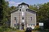 |
(#91000306) |
Imlaydale Rd. and surrounding land between NJ 31 and the Musconetcong R., Washington and Lebanon Townships 40°42′50″N 74°58′05″W / 40.713889°N 74.968056°W |
Hampton | includes part of Hunterdon County |
| 18 | Johnsonburg Historic District |  |
(#92001386) |
NJ 519 and 661 and adjacent parts of Mott and Allamuchy Rds., Frelinghuysen Township 40°57′59″N 74°52′36″W / 40.966389°N 74.876667°W |
Johnsonburg | |
| 19 | Kennedy House and Mill |  |
(#96000552) |
306 NJ 173, Greenwich Township 40°39′41″N 75°06′56″W / 40.661389°N 75.115556°W |
Stewartsville | |
| 20 | Lander-Stewart Mansion and Stites Building | 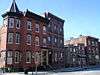 |
(#08000561) |
102-104 S. Main St. 40°41′23″N 75°12′04″W / 40.689701°N 75.201051°W |
Phillipsburg | |
| 21 | Miller Farmstead |  |
(#88002118) |
NJ 57 40°47′19″N 74°53′41″W / 40.788611°N 74.894722°W |
Anderson | |
| 22 | Morris Canal | 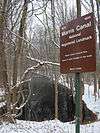 |
(#74002228) |
Irregular line beginning at Phillipsburg and ending at Jersey City 40°41′08″N 75°09′49″W / 40.685556°N 75.163611°W |
Not Applicable | |
| 23 | Mount Bethel Methodist Church | 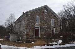 |
(#80002526) |
W of Hackettstown at intersection of Mount Bethel Rd. and Snyder Rd. 40°49′32″N 74°54′07″W / 40.825556°N 74.901944°W |
Hackettstown | |
| 24 | New Hampton Pony Pratt Truss Bridge | 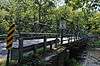 |
(#77000877) |
N of Hampton over Musconetcong River 40°43′13″N 74°57′50″W / 40.720278°N 74.963889°W |
Changewater | |
| 25 | Old Mine Road Historic District | Upload image | (#80000410) |
NJ 521, Delaware, Old Mine, and River Rds. 41°09′15″N 74°55′04″W / 41.154167°N 74.917778°W |
Wallpack Center | |
| 26 | Oxford Furnace | 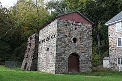 |
(#77000919) |
Belvidere and Washington Aves. 40°48′14″N 74°59′52″W / 40.803889°N 74.997778°W |
Oxford | |
| 27 | Oxford Industrial Historic District | 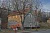 |
(#91001471) |
NJ 31, Mine Hill Rd., Belvidere and Axford Aves., Oxford Township 40°47′55″N 74°59′42″W / 40.798611°N 74.995°W |
Oxford | |
| 28 | Perry-Petty Farmstead | 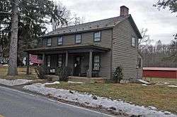 |
(#99000392) |
882 Jackson Valley Rd. 40°48′07″N 74°56′24″W / 40.801944°N 74.94°W |
Mansfield Township | |
| 29 | Phillipsburg Commercial Historic District | 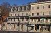 |
(#08000973) |
29-169 S. Main St., 60-178 S. Main St., 3 Hudson St., 9 and 12-30 Morris St./Main St., 7-11, 17, and 21-27 Union Sq. 40°41′29″N 75°12′08″W / 40.691389°N 75.202222°W |
Phillipsburg | |
| 30 | Pleasant Valley Historic District | 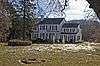 |
(#94000013) |
Area surrounding Mill Pond Rd., Washington Township 40°44′59″N 75°00′17″W / 40.749722°N 75.004722°W |
Pleasant Valley | |
| 31 | Port Colden Historic District | 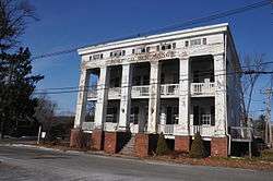 |
(#98001639) |
Roughly along Port Colden Rd., Lock St., NJ 57, and Morris Canal Terrace 40°45′59″N 74°57′17″W / 40.766389°N 74.954722°W |
Washington Township | |
| 32 | Port Murray Historic District | 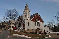 |
(#96000658) |
Roughly, Port Murray Rd. from Cherry Tree Bend Rd. to Hoffman Rd., Mansfield Township 40°47′26″N 74°55′01″W / 40.790556°N 74.916944°W |
Washington | |
| 33 | Ramsaysburg Homestead | 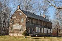 |
(#04001194) |
NJ 46 40°52′45″N 75°03′20″W / 40.879167°N 75.055556°W |
Knowlton | |
| 34 | John Richey House | 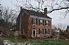 |
(#02000216) |
6 Schetzer Ln. 40°43′06″N 75°00′14″W / 40.718333°N 75.003889°W |
Franklin | |
| 35 | John Roseberry Homestead | 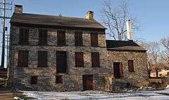 |
(#73001139) |
540 Warren St. 40°41′19″N 75°10′54″W / 40.688611°N 75.181667°W |
Phillipsburg | |
| 36 | St. James Lutheran Church and Cemetery | Upload image | (#16000737) |
1213 US 22 40°40′49″N 75°08′45″W / 40.680373°N 75.145768°W |
Pohatcong Township | |
| 37 | Seigle Homestead | 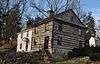 |
(#77000918) |
N of Finesville 40°36′39″N 75°09′59″W / 40.610833°N 75.166389°W |
Finesville | |
| 38 | Shippen Manor |  |
(#84000517) |
Belvidere Rd. 40°48′19″N 74°59′51″W / 40.805278°N 74.9975°W |
Oxford | |
| 39 | Spring Valley Christian Church Site |  |
(#97001147) |
Spring Valley Rd., 0.5 mi (0.80 km). E of Hardwick Center 41°00′20″N 74°56′23″W / 41.005556°N 74.939722°W |
Hardwick Township | |
| 40 | St. Luke's Episcopal Church | 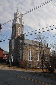 |
(#07000151) |
346 High St. 40°54′37″N 74°58′09″W / 40.910278°N 74.969167°W |
Hope | |
| 41 | Van Nest-Hoff-Vannatta Farmstead | 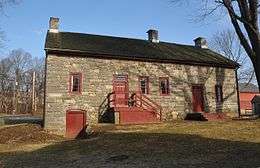 |
(#05001484) |
Cty Rd. 519 40°45′47″N 75°07′49″W / 40.763056°N 75.130278°W |
Harmony | |
| 42 | Vass Farmstead |  |
(#99001170) |
109 Stillwater Rd. 41°00′15″N 74°55′01″W / 41.004167°N 74.916944°W |
Hardwick | |
| 43 | Warrington Stone Bridge | 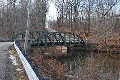 |
(#77000917) |
NE of Columbia off NJ 94 40°55′59″N 75°04′30″W / 40.933056°N 75.075°W |
Columbia | Old bridge replaced |
| 44 | Washington Railroad Station |  |
(#79001532) |
Railroad Ave. 40°45′30″N 74°58′06″W / 40.758333°N 74.968333°W |
Washington |
See also
| Wikimedia Commons has media related to National Register of Historic Places in Warren County, New Jersey. |
- National Register of Historic Places listings in New Jersey
- List of National Historic Landmarks in New Jersey
References
- ↑ The latitude and longitude information provided in this table was derived originally from the National Register Information System, which has been found to be fairly accurate for about 99% of listings. For about 1% of NRIS original coordinates, experience has shown that one or both coordinates are typos or otherwise extremely far off; some corrections may have been made. A more subtle problem causes many locations to be off by up to 150 yards, depending on location in the country: most NRIS coordinates were derived from tracing out latitude and longitudes off of USGS topographical quadrant maps created under the North American Datum of 1927, which differs from the current, highly accurate WGS84 GPS system used by most on-line maps. Chicago is about right, but NRIS longitudes in Washington are higher by about 4.5 seconds, and are lower by about 2.0 seconds in Maine. Latitudes differ by about 1.0 second in Florida. Some locations in this table may have been corrected to current GPS standards.
- ↑ "National Register of Historic Places: Weekly List Actions". National Park Service, United States Department of the Interior. Retrieved on December 16, 2016.
- ↑ Numbers represent an ordering by significant words. Various colorings, defined here, differentiate National Historic Landmarks and historic districts from other NRHP buildings, structures, sites or objects.
- ↑ National Park Service (2008-04-24). "National Register Information System". National Register of Historic Places. National Park Service.
- ↑ The eight-digit number below each date is the number assigned to each location in the National Register Information System database, which can be viewed by clicking the number.
| Topics | |
|---|---|
| Lists by states |
|
| Lists by insular areas | |
| Lists by associated states | |
| Other areas | |
| |
This article is issued from Wikipedia - version of the 11/6/2016. The text is available under the Creative Commons Attribution/Share Alike but additional terms may apply for the media files.