Upper Freehold Township, New Jersey
| Upper Freehold Township, New Jersey | |
|---|---|
| Township | |
| Township of Upper Freehold | |
|
Entrance to the Horse Park of New Jersey | |
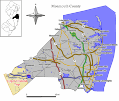 Map of Upper Freehold Township in Monmouth County. Inset: Location of Monmouth County highlighted in the State of New Jersey. | |
 Census Bureau map of Upper Freehold Township, New Jersey | |
| Coordinates: 40°09′13″N 74°31′39″W / 40.153659°N 74.527536°WCoordinates: 40°09′13″N 74°31′39″W / 40.153659°N 74.527536°W[1][2] | |
| Country |
|
| State |
|
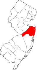
| County | Monmouth |
| Established | 1731 |
| Incorporated | February 21, 1798 |
| Government[3] | |
| • Type | Township |
| • Body | Township Committee |
| • Mayor | Stanley Moslowski, Jr. (R, term ends December 31, 2016)[4][5] |
| • Administrator | Dianne Kelly[6] |
| • Clerk | Dana L. Tyler[7] |
| Area[1] | |
| • Total | 47.235 sq mi (122.337 km2) |
| • Land | 46.419 sq mi (120.223 km2) |
| • Water | 0.816 sq mi (2.114 km2) 1.73% |
| Area rank |
35th of 566 in state 3rd of 53 in county[1] |
| Elevation[8] | 108 ft (33 m) |
| Population (2010 Census)[9][10][11] | |
| • Total | 6,902 |
| • Estimate (2015)[12] | 6,887 |
| • Rank |
321st of 566 in state 25th of 53 in county[13] |
| • Density | 148.7/sq mi (57.4/km2) |
| • Density rank |
525th of 566 in state 53rd of 53 in county[13] |
| Time zone | Eastern (EST) (UTC-5) |
| • Summer (DST) | Eastern (EDT) (UTC-4) |
| ZIP code | 08501[14] |
| Area code(s) | 609 exchanges: 208, 259, 752, 758[15] |
| FIPS code | 3402574900[1][16][17] |
| GNIS feature ID | 0882114[1][18] |
| Website |
www |

Upper Freehold Township is a township in Monmouth County, New Jersey, United States. As of the 2010 United States Census, the township's population was 6,902,[9][10][11] reflecting an increase of 2,620 (+61.2%) from the 4,282 counted in the 2000 Census, which had in turn increased by 1,005 (+30.7%) from the 3,277 counted in the 1990 Census.[19]
History
Upper Freehold Township dates back to 1731, when it was formed from portions of Freehold Township. It was formally incorporated as a township by the Township Act of 1798 of the New Jersey Legislature on February 21, 1798. Over the years, portions of the township have been taken to form Millstone Township (February 28, 1844), Jackson Township (March 6, 1844) and Allentown (January 20, 1889).[20] The name of the township derives from Freehold Township, which in turn comes from the word freehold, an English legal term describing fee simple property ownership.[21]
Geography
According to the United States Census Bureau, the township had a total area of 47.235 square miles (122.337 km2), including 46.419 square miles (120.223 km2) of land and 0.816 square miles (2.114 km2) of water (1.73%).[1][2]
Unincorporated communities within the township include Arneytown, Cooleys Corner, Coxs Corner, Cream Ridge, Davis, Ellisdale, Emleys Hill, Fillmore, Hayti, Homes Mills, Hornerstown, Imlaystown, Kirbys Mills, Nelsonville, New Canton, New Sharon, Polhemustown, Prospertown, Pullentown, Red Valley, Robinsville, Sharon, Shrewsbury, Spring Mill, Walnford and Wrightsville.[22]
The township borders Allentown, Millstone Township and Roosevelt in Monmouth County; North Hanover Township in Burlington County; East Windsor Township, Hamilton Township and Robbinsville Township in Mercer County; and Jackson Township and Plumsted Township in Ocean County.[23]
Farming and other agricultural uses have been primary uses of land in the area since the time that the township was first formed. The township has 6,000 acres (2,400 ha) of land protected from development as part of a Farmland Preservation Program. Voters were the first in the county to approve a dedicated portion of property taxes to fund farmland preservation, which was increased by a 2001 referendum to four cents per $100 of assessed value, split between farmland preservation and the costs associated with purchasing and developing land for recreational uses.[24]
The Assunpink Wildlife Preservation Area, of which more than 2,500 acres (1,000 ha) of the preserve's 6,300 acres (2,500 ha) are located in the township, as well as in portions of Millstone Township, Roosevelt and Robbinsville Township, offers wetlands and lakes for viewing migratory birds, in addition to mountain biking trails, bridle paths and hiking trails, operated under the supervision of the New Jersey Department of Environmental Protection Division of Fish and Wildlife.[24][25][26][26]
Demographics
| Historical population | |||
|---|---|---|---|
| Census | Pop. | %± | |
| 1790 | 3,442 | — | |
| 1810 | 3,843 | — | |
| 1820 | 4,541 | 18.2% | |
| 1830 | 4,826 | 6.3% | |
| 1840 | 5,026 | 4.1% | |
| 1850 | 2,566 | * | −48.9% |
| 1860 | 3,198 | 24.6% | |
| 1870 | 3,640 | 13.8% | |
| 1880 | 3,236 | −11.1% | |
| 1890 | 2,861 | * | −11.6% |
| 1900 | 2,112 | −26.2% | |
| 1910 | 2,053 | −2.8% | |
| 1920 | 1,737 | −15.4% | |
| 1930 | 1,867 | 7.5% | |
| 1940 | 1,839 | −1.5% | |
| 1950 | 2,193 | 19.2% | |
| 1960 | 2,363 | 7.8% | |
| 1970 | 2,551 | 8.0% | |
| 1980 | 2,750 | 7.8% | |
| 1990 | 3,277 | 19.2% | |
| 2000 | 4,282 | 30.7% | |
| 2010 | 6,902 | 61.2% | |
| Est. 2015 | 6,887 | [12][27] | −0.2% |
| Population sources: 1790-1920[28] 1840[29] 1850-1870[30] 1850[31] 1870[32] 1880-1890[33] 1900-1910[34] 1910-1930[35] 1930-1990[36] 2000[37][38] 2010[9][10][11] * = Lost territory in previous decade.[20] | |||
Census 2010
The 2010 United States Census counted 6,902 people, 2,363 households, and 1,978 families residing in the township. The population density was 148.7 per square mile (57.4/km2). The township contained 2,458 housing units at an average density of 53.0 per square mile (20.5/km2). The racial makeup of the township was 91.50% (6,315) White, 2.01% (139) Black or African American, 0.14% (10) Native American, 4.35% (300) Asian, 0.01% (1) Pacific Islander, 0.67% (46) from other races, and 1.32% (91) from two or more races. Hispanics or Latinos of any race were 3.68% (254) of the population.[9]
Out of a total of 2,363 households, 38.1% had children under the age of 18 living with them, 76.5% were married couples living together, 4.9% had a female householder with no husband present, and 16.3% were non-families. 12.6% of all households were made up of individuals, and 6.1% had someone living alone who was 65 years of age or older. The average household size was 2.92 and the average family size was 3.19.[9]
In the township, 26.6% of the population were under the age of 18, 5.2% from 18 to 24, 20.4% from 25 to 44, 33.7% from 45 to 64, and 14.0% who were 65 years of age or older. The median age was 43.7 years. For every 100 females the census counted 98.6 males, but for 100 females at least 18 years old, it was 97.3 males.[9]
The Census Bureau's 2006-2010 American Community Survey showed that (in 2010 inflation-adjusted dollars) median household income was $122,525 (with a margin of error of +/- $16,693) and the median family income was $126,849 (+/- $10,754). Males had a median income of $100,583 (+/- $18,963) versus $65,183 (+/- $5,414) for females. The per capita income for the borough was $48,665 (+/- $3,717). About 2.3% of families and 2.5% of the population were below the poverty line, including 3.8% of those under age 18 and 2.9% of those age 65 or over.[39]
Census 2000
As of the 2000 United States Census[16] there were 4,282 people, 1,437 households, and 1,198 families residing in the township. The population density was 91.4 people per square mile (35.3/km2). There were 1,501 housing units at an average density of 32.0 per square mile (12.4/km2). The racial makeup of the township was 94.70% White, 1.05% African American, 0.14% Native American, 1.40% Asian, 0.84% from other races, and 1.87% from two or more races. Hispanic or Latino of any race were 3.53% of the population.[37][38]
There were 1,437 households out of which 42.7% had children under the age of 18 living with them, 74.7% were married couples living together, 5.5% had a female householder with no husband present, and 16.6% were non-families. 11.7% of all households were made up of individuals and 5.2% had someone living alone who was 65 years of age or older. The average household size was 2.96 and the average family size was 3.24.[37][38]
In the township the population was spread out with 27.8% under the age of 18, 5.0% from 18 to 24, 32.1% from 25 to 44, 25.6% from 45 to 64, and 9.4% who were 65 years of age or older. The median age was 38 years. For every 100 females there were 101.7 males. For every 100 females age 18 and over, there were 98.7 males.[37][38]
The median income for a household in the township was $71,250, and the median income for a family was $78,334. Males had a median income of $55,987 versus $35,221 for females. The per capita income for the township was $29,387. About 4.3% of families and 4.0% of the population were below the poverty line, including 1.3% of those under age 18 and 11.6% of those age 65 or over.[37][38]
Parks and recreation
The Horse Park of New Jersey was conceived by equestrian enthusiasts concerned about the dwindling amount of land dedicated to their interests and activities. The Horse Park opened in 1987 on land initially purchased by the New Jersey Department of Environmental Protection with Green Acres funds, based on the input of the state's Equine Advisory Board, and is centrally located in Monmouth County's equine-oriented countryside.[24][40][41]
Monmouth County parks in the township include Clayton Park, a passive recreation area with woodlands and hiking trails covering a total of 438 acres (177 ha) of land that dates back to a purchase of land in 1978 from an area farmer who sold the land to the county below market value to ensure that the land would be preserved.[42][43]
Historic Walnford includes a restored Georgian style house, working mill, carriage house and cow barn that were all part of an industrial community dating back almost 200 years that was developed by the Waln family on a site that covers 38 acres (15 ha).[44][45] The Crosswicks Creek Greenbelt includes 328 acres (133 ha) of land in the township, as part of a corridor running along the Crosswicks Creek from Fort Dix in Burlington County towards the Delaware River along the border between Burlington and Mercer County, traveling through Upper Freehold Township and including Historic Walnford.[46][47]
A bond ordinance passed in 2000 provides for the development of soccer fields, baseball fields and basketball courts at the Byron Johnson Recreation Area and other township parks. The Byron Johnson site adjoins Allentown High School near the Allentown border, and is owned by Monmouth County and administered by the township, developed using municipal funds and monies contributed by developers.[24][48]
Government
Local government
Upper Freehold Township is governed under the Township form of government. The five-member Township Committee is elected directly by the voters at-large in partisan elections to serve three-year terms of office on a staggered basis, with either one or two seats coming up for election each year as part of the November general election in a three-year cycle.[3][49] At an annual reorganization meeting, the Township Committee selects one of its members to serve as Mayor and another as Deputy Mayor.
As of 2016, members of the Upper Freehold Township Committee are Mayor Stanley Moslowski, Jr. (R, term on committee and as mayor ends December 31, 2016), Deputy Mayor Dr. Robert A. Frascella (R, term on committee ends 2017; term as deputy mayor ends 2016), Steve J. Alexander (R, 2018), Robert J. Faber, Sr. (R, 2018) and LoriSue H. Mount (R, 2016).[4][50][51][52][53][54]
Federal, state and county representation
Upper Freehold Township is located in the 4th Congressional District[55] and is part of New Jersey's 12th state legislative district.[10][56][57] Prior to the 2011 reapportionment following the 2010 Census, Upper Freehold Township had been in the 30th state legislative district.[58]
New Jersey's Fourth Congressional District is represented by Christopher Smith (R).[59] New Jersey is represented in the United States Senate by Cory Booker (D, Newark, term ends 2021)[60] and Bob Menendez (D, Paramus, 2019).[61][62]
For the 2016–2017 session (Senate, General Assembly), the 12th Legislative District of the New Jersey Legislature is represented in the State Senate by Samuel D. Thompson (R, Old Bridge Township) and in the General Assembly by Robert D. Clifton (R, Matawan) and Ronald S. Dancer (R, Plumsted Township).[63] The Governor of New Jersey is Chris Christie (R, Mendham Township).[64] The Lieutenant Governor of New Jersey is Kim Guadagno (R, Monmouth Beach).[65]
Monmouth County is governed by a Board of Chosen Freeholders consisting of five members who are elected at-large to serve three year terms of office on a staggered basis, with either one or two seats up for election each year as part of the November general election. At an annual reorganization meeting held in the beginning of January, the board selects one of its members to serve as Director and another as Deputy Director.[66] As of 2014, Monmouth County's Freeholders are Freeholder Director Lillian G. Burry (R, Colts Neck Township; term ends December 31, 2014),[67] Freeholder Deputy Director Gary J. Rich, Sr. (R, Spring Lake; 2014),[68] Thomas A. Arnone (R, Neptune City; 2016),[69] John P. Curley (R, Middletown Township; 2015)[70] and Serena DiMaso (R, Holmdel Township; 2016).[71][72] Constitutional officers elected on a countywide basis are County Clerk M. Claire French (Wall Township),[73] Sheriff Shaun Golden (Farmingdale)[74] and Surrogate Rosemarie D. Peters (Middletown Township).[75]
Politics
As of March 23, 2011, there were a total of 4,686 registered voters in Upper Freehold Township, of which 722 (15.4%) were registered as Democrats, 2,218 (47.3%) were registered as Republicans and 1,741 (37.2%) were registered as Unaffiliated. There were 5 voters registered to other parties.[76]
In the 2012 presidential election, Republican Mitt Romney received 61.9% of the vote (2,287 cast), ahead of Democrat Barack Obama with 37.1% (1,372 votes), and other candidates with 1.0% (36 votes), among the 3,723 ballots cast by the township's 4,818 registered voters (28 ballots were spoiled), for a turnout of 77.3%.[77][78] In the 2008 presidential election, Republican John McCain received 60.3% of the vote (2,337 cast), ahead of Democrat Barack Obama with 37.7% (1,461 votes) and other candidates with 1.0% (40 votes), among the 3,878 ballots cast by the township's 4,893 registered voters, for a turnout of 79.3%.[79] In the 2004 presidential election, Republican George W. Bush received 63.2% of the vote (2,153 ballots cast), outpolling Democrat John Kerry with 35.6% (1,212 votes) and other candidates with 0.7% (31 votes), among the 3,409 ballots cast by the township's 4,203 registered voters, for a turnout percentage of 81.1.[80]
In the 2013 gubernatorial election, Republican Chris Christie received 75.4% of the vote (1,827 cast), ahead of Democrat Barbara Buono with 23.0% (558 votes), and other candidates with 1.6% (39 votes), among the 2,442 ballots cast by the township's 4,893 registered voters (18 ballots were spoiled), for a turnout of 49.9%.[81][82] In the 2009 gubernatorial election, Republican Chris Christie received 69.5% of the vote (1,972 ballots cast), ahead of Democrat Jon Corzine with 23.8% (676 votes), Independent Chris Daggett with 5.4% (153 votes) and other candidates with 0.7% (20 votes), among the 2,836 ballots cast by the township's 4,737 registered voters, yielding a 59.9% turnout.[83]
Education
Students in public school for Kindergarten through twelfth grade attend the Upper Freehold Regional School District, which serves students from Allentown Borough and Upper Freehold Township. Millstone Township sends students to the district's high school as part of a sending/receiving relationship with the Millstone Township Schools.[84] Schools in the district (with 2012-13 enrollment data from the National Center for Education Statistics[85]) are Newell Elementary School[86] (575 students in grades PreK-4), Stone Bridge Middle School[87] (544; 5-8) and Allentown High School[88] (1,233; 9-12).[89]
Transportation
As of May 2010, the township had a total of 116.01 miles (186.70 km) of roadways, of which 82.01 miles (131.98 km) were maintained by the municipality, 28.28 miles (45.51 km) by Monmouth County and 5.72 miles (9.21 km) by the New Jersey Department of Transportation.[90]
A 5.7-mile (9.2 km) portion of the Central Jersey Expressway (Interstate 195) goes through Upper Freehold, making it an important artery for residents of the township.[91] Exit 11 leads to the Horse Park of New Jersey. Exit 8 leads to County Route 539 (Hornerstown Road / Trenton-Forked River Road / Davis-Allentown Road) to Hightstown, or towards the Garden State Parkway south to Atlantic City.[92] County Route 524 (called Yardville-Allentown Road / South Main Street where it enters Allentown / Stage Coach Road) heads across the township, mostly to the north of Interstate 195, from Hamilton Township in Mercer County to the east and Millstone Township to the west.[93] County Route 526 (Walker Avenue) heads from Allentown in the east to Millstone Township in the west, paralleling Interstate 195 to the north.[94] County Route 537 (Monmouth Road) runs for 6.5 miles (10.5 km) along the township's southern borders with the Ocean County municipalities of Plumsted Township and Jackson Township.[95]
In addition, Interstate 95 (the New Jersey Turnpike) is minutes away along I-195 in neighboring Robbinsville Township (Exit 7A) and not too far also in bordering East Windsor (Exit 8).
Points of interest
The Cream Ridge Winery is located in the township.
Notable people
People who were born in, residents of, or otherwise closely associated with Upper Freehold Township include:
- Joseph Holmes (1736-1809), member of the New Jersey Legislative Council who served on the Upper Freehold Township Committee and on the county Board of Chosen Freeholders.[96]
- Gilbert Imlay (1754-1828), businessman, author and diplomat.[97]
- Elisha Lawrence (1746-1799), politician who served as Vice-President of Council from 1789 through 1792, and again in 1795.[98]
- Chris Tomson (born 1984), drummer with the band Vampire Weekend.[99]
- Samuel G. Wright (1781-1845), politician who was elected to represent New Jersey's 2nd congressional district in 1845 but died before he could take office.[100]
References
- 1 2 3 4 5 6 2010 Census Gazetteer Files: New Jersey County Subdivisions, United States Census Bureau. Accessed May 21, 2015.
- 1 2 US Gazetteer files: 2010, 2000, and 1990, United States Census Bureau. Accessed September 4, 2014.
- 1 2 2012 New Jersey Legislative District Data Book, Rutgers University Edward J. Bloustein School of Planning and Public Policy, March 2013, p. 135.
- 1 2 Township Committee, Upper Freehold Township. Accessed July 19, 2016.
- ↑ 2016 New Jersey Mayors Directory, New Jersey Department of Community Affairs. Accessed June 14, 2016.
- ↑ Administration, Upper Freehold Township. Accessed July 19, 2016.
- ↑ Municipal Clerk, Upper Freehold Township. Accessed July 19, 2016.
- ↑ U.S. Geological Survey Geographic Names Information System: Township of Upper Freehold, Geographic Names Information System. Accessed March 14, 2013.
- 1 2 3 4 5 6 DP-1 - Profile of General Population and Housing Characteristics: 2010 for Upper Freehold township, Monmouth County, New Jersey, United States Census Bureau. Accessed August 2, 2012.
- 1 2 3 4 Municipalities Grouped by 2011-2020 Legislative Districts, New Jersey Department of State, p. 7. Accessed January 6, 2013.
- 1 2 3 Profile of General Demographic Characteristics: 2010 for Upper Freehold township, New Jersey Department of Labor and Workforce Development. Accessed August 2, 2012.
- 1 2 PEPANNRES - Annual Estimates of the Resident Population: April 1, 2010 to July 1, 2015 - 2015 Population Estimates for New Jersey municipalities, United States Census Bureau. Accessed May 22, 2016.
- 1 2 GCT-PH1 Population, Housing Units, Area, and Density: 2010 - State -- County Subdivision from the 2010 Census Summary File 1 for New Jersey, United States Census Bureau. Accessed December 13, 2012.
- ↑ Look Up a ZIP Code for Upper Freehold, NJ, United States Postal Service. Accessed August 2, 2012.
- ↑ Area Code Lookup - NPA NXX for Upper Freehold, NJ, Area-Codes.com. Accessed October 28, 2013.
- 1 2 American FactFinder, United States Census Bureau. Accessed September 4, 2014.
- ↑ A Cure for the Common Codes: New Jersey, Missouri Census Data Center. Accessed August 2, 2012.
- ↑ US Board on Geographic Names, United States Geological Survey. Accessed September 4, 2014.
- ↑ Table 7. Population for the Counties and Municipalities in New Jersey: 1990, 2000 and 2010, New Jersey Department of Labor and Workforce Development, February 2011. Accessed August 2, 2012.
- 1 2 Snyder, John P. The Story of New Jersey's Civil Boundaries: 1606-1968, Bureau of Geology and Topography; Trenton, New Jersey; 1969. p. 186. Accessed August 2, 2012.
- ↑ Gannett, Henry. The Origin of Certain Place Names in the United States, p. 198. United States Government Printing Office, 1905. Accessed August 31, 2015.
- ↑ Locality Search, State of New Jersey. Accessed November 7, 2013.
- ↑ Areas touching Upper Freehold Township, MapIt. Accessed July 26, 2015.
- 1 2 3 4 About Our Community, Upper Freehold Township. Accessed October 28, 2013.
- ↑ Assunpink Wildlife Management Area, New York-New Jersey Trail Conference. Accessed October 28, 2013.
- 1 2 Assunpink Wildlife Management Area, New Jersey Department of Environmental Protection Division of Fish and Wildlife. Accessed October 28, 2013.
- ↑ Census Estimates for New Jersey April 1, 2010 to July 1, 2015, United States Census Bureau. Accessed May 22, 2016.
- ↑ Compendium of censuses 1726-1905: together with the tabulated returns of 1905, New Jersey Department of State, 1906. Accessed July 21, 2013.
- ↑ Bowen, Francis. American Almanac and Repository of Useful Knowledge for the Year 1843, p. 231, David H. Williams, 1842. Accessed July 21, 2013.
- ↑ Raum, John O. The History of New Jersey: From Its Earliest Settlement to the Present Time, Volume 1, p. 252, J. E. Potter and company, 1877. Accessed July 21, 2013. "Upper Freehold township contained in 1850, 2,566 inhabitants; in 1860, 3,198; and in 1870, 3,640."
- ↑ Debow, James Dunwoody Brownson. The Seventh Census of the United States: 1850, p. 140. R. Armstrong, 1853. Accessed December 11, 2012.
- ↑ Staff. A compendium of the ninth census, 1870, p. 260. United States Census Bureau, 1872. Accessed December 11, 2012.
- ↑ Porter, Robert Percival. Preliminary Results as Contained in the Eleventh Census Bulletins: Volume III - 51 to 75, p. 99. United States Census Bureau, 1890. Accessed August 2, 2012.
- ↑ Thirteenth Census of the United States, 1910: Population by Counties and Minor Civil Divisions, 1910, 1900, 1890, United States Census Bureau, p. 338. Accessed August 2, 2012.
- ↑ Fifteenth Census of the United States : 1930 - Population Volume I, United States Census Bureau, p. 717. Accessed August 2, 2012.
- ↑ Table 6. New Jersey Resident Population by Municipality: 1930 - 1990, New Jersey Department of Labor and Workforce Development. Accessed June 28, 2015.
- 1 2 3 4 5 Census 2000 Profiles of Demographic / Social / Economic / Housing Characteristics for Upper Freehold township, Monmouth County, New Jersey, United States Census Bureau. Accessed August 2, 2012.
- 1 2 3 4 5 DP-1: Profile of General Demographic Characteristics: 2000 - Census 2000 Summary File 1 (SF 1) 100-Percent Data for Upper Freehold township, Monmouth County, New Jersey, United States Census Bureau. Accessed August 2, 2012.
- ↑ DP03: Selected Economic Characteristics from the 2006-2010 American Community Survey 5-Year Estimates for Upper Freehold township, Monmouth County, New Jersey, United States Census Bureau. Accessed June 21, 2012.
- ↑ Collins, Helen Lippman; Reardon, Patricia. "FOR EQUESTRIANS, EVERY DAY IS A DAY FOR RIDING OR PRACTICING", The New York Times, November 1, 1987. Accessed October 28, 2013. "Horse Park, in Upper Freehold Township, is a project of the state's Equine Advisory Board. When completed, it will be a first-class facility for competitive horsemanship, complete with outdoor show rings, seats for a large group of spectators, a polo field and jumping and steeplechase courses."
- ↑ Horse Park of New Jersey, Get Outside NJ. Accessed October 28, 2013.
- ↑ Clayton Park brochure and map, Monmouth County Park System. Accessed October 28, 2013.
- ↑ Clayton Park, Monmouth County Park System. Accessed October 28, 2013.
- ↑ Historic Walnford, Monmouth County Park System. Accessed October 28, 2013.
- ↑ Historic Walnford brochure and map, Monmouth County Park System. Accessed October 28, 2013.
- ↑ Crosswicks Creek Greenway, Monmouth County Park System. Accessed October 28, 2013.
- ↑ Crosswicks Creek Greenway & Union Transportation Trail brochure and map, Monmouth County Park System. Accessed October 28, 2013.
- ↑ Hahn, Keith. "Upper Freehold approves funds for park development ", Examiner, December 20, 2000. Accessed October 28, 2013."The bond will provide $1 million for the construction of the Byron Johnson park as well as other parks scheduled for the future.... The 28-acre Byron Johnson site will feature soccer fields, youth baseball fields and basketball courts. The park will be developed next to Allentown High School, High Street, near the border of Allentown and Upper Freehold. While the land is owned by Monmouth County, Upper Freehold will maintain control over scheduling of recreation events on the site.
- ↑ "Forms of Municipal Government in New Jersey", p. 7. Rutgers University Center for Government Studies. Accessed June 3, 2015.
- ↑ 2016 Municipal Data Sheet, Upper Freehold Township. Accessed July 19, 2016.
- ↑ Monmouth County Directory 2016, Monmouth County, New Jersey. Accessed July 14, 2016.
- ↑ November 3, 2015 General Election Official Results, Monmouth County, New Jersey, updated January 27, 2016. Accessed July 14, 2016.
- ↑ November 4, 2014 General Election Official Results, Monmouth County, New Jersey, updated November 24, 2014. Accessed July 14, 2016.
- ↑ Official Election Results - General Election November 5, 2013, Monmouth County, New Jersey Accessed July 14, 2016.
- ↑ Plan Components Report, New Jersey Redistricting Commission, December 23, 2011. Accessed January 6, 2013.
- ↑ 2016 New Jersey Citizen's Guide to Government, p. 65, New Jersey League of Women Voters. Accessed July 20, 2016.
- ↑ Districts by Number for 2011-2020, New Jersey Legislature. Accessed January 6, 2013.
- ↑ 2011 New Jersey Citizen's Guide to Government, p. 65, New Jersey League of Women Voters. Accessed May 22, 2015.
- ↑ Directory of Representatives: New Jersey, United States House of Representatives. Accessed January 5, 2012.
- ↑ About Cory Booker, United States Senate. Accessed January 26, 2015. "He now owns a home and lives in Newark's Central Ward community."
- ↑ Biography of Bob Menendez, United States Senate, January 26, 2015. "He currently lives in Paramus and has two children, Alicia and Robert."
- ↑ Senators of the 114th Congress from New Jersey. United States Senate. Accessed January 26, 2015. "Booker, Cory A. - (D - NJ) Class II; Menendez, Robert - (D - NJ) Class I"
- ↑ Legislative Roster 2016-2017 Session, New Jersey Legislature. Accessed January 17, 2016.
- ↑ "About the Governor". State of New Jersey. Retrieved 2010-01-21.
- ↑ "About the Lieutenant Governor". State of New Jersey. Retrieved 2010-01-21.
- ↑ Monmouth County Government, Monmouth County, New Jersey. Accessed February 4, 2014.
- ↑ Freeholder Lillian G. Burry, Monmouth County, New Jersey. Accessed February 4, 2014.
- ↑ Freeholder Gary J. Rich Sr., Monmouth County, New Jersey. Accessed February 4, 2014.
- ↑ Freeholder Director Thomas A. Arnone, Monmouth County, New Jersey. Accessed February 4, 2014.
- ↑ Freeholder John P. Curley, Monmouth County, New Jersey. Accessed February 4, 2014.
- ↑ Freeholder Deputy Director Serena DiMaso, Monmouth County, New Jersey. Accessed February 4, 2014.
- ↑ Freeholder Gary J. Rich Sr., Monmouth County, New Jersey. Accessed February 4, 2014.
- ↑ About the County Clerk, M. Claire French, Monmouth County, New Jersey. Accessed February 4, 2014.
- ↑ Sheriff Shaun Golden, Monmouth County Sheriff's Office. Accessed February 4, 2014.
- ↑ Monmouth County Surrogate, Monmouth County, New Jersey. Accessed February 4, 2014.
- ↑ Voter Registration Summary - Monmouth, New Jersey Department of State Division of Elections, March 23, 2011. Accessed December 13, 2012.
- ↑ "Presidential General Election Results - November 6, 2012 - Monmouth County" (PDF). New Jersey Department of Elections. March 15, 2013. Retrieved December 24, 2014.
- ↑ "Number of Registered Voters and Ballots Cast - November 6, 2012 - General Election Results - Monmouth County" (PDF). New Jersey Department of Elections. March 15, 2013. Retrieved December 24, 2014.
- ↑ 2008 Presidential General Election Results: Monmouth County, New Jersey Department of State Division of Elections, December 23, 2008. Accessed December 13, 2012.
- ↑ 2004 Presidential Election: Monmouth County, New Jersey Department of State Division of Elections, December 13, 2004. Accessed December 13, 2012.
- ↑ "Governor - Monmouth County" (PDF). New Jersey Department of Elections. January 29, 2014. Retrieved December 24, 2014.
- ↑ "Number of Registered Voters and Ballots Cast - November 5, 2013 - General Election Results - Monmouth County" (PDF). New Jersey Department of Elections. January 29, 2014. Retrieved December 24, 2014.
- ↑ 2009 Governor: Monmouth County, New Jersey Department of State Division of Elections, December 31, 2009. Accessed December 13, 2012.
- ↑ Upper Freehold Regional School District 2015 School Report Card Narrative, New Jersey Department of Education. Accessed March 23, 2015. "The Allentown High School (AHS) welcomes students from Allentown, Upper Freehold, and Millstone as well as qualified Choice students from communities within a twenty mile radius of our campus."
- ↑ School Data for the Upper Freehold Regional School District, National Center for Education Statistics. Accessed June 15, 2015.
- ↑ Newell Elementary School, Upper Freehold Regional School District. Accessed August 23, 2013.
- ↑ Stone Bridge Middle School, Upper Freehold Regional School District. Accessed August 23, 2013.
- ↑ Allentown High School, Upper Freehold Regional School District. Accessed August 23, 2013.
- ↑ New Jersey School Directory for the Upper Freehold Regional School District, New Jersey Department of Education. Accessed August 23, 2013.
- ↑ Monmouth County Mileage by Municipality and Jurisdiction, New Jersey Department of Transportation, May 2010. Accessed November 7, 2013.
- ↑ Interstate 195 Straight Line Diagram, New Jersey Department of Transportation, February 2010. Accessed November 7, 2013.
- ↑ County Route 539 Straight Line Diagram, New Jersey Department of Transportation, August 2006. Accessed November 7, 2013.
- ↑ County Route 524 Straight Line Diagram, New Jersey Department of Transportation, July 2006. Accessed November 7, 2013.
- ↑ County Route 526 Straight Line Diagram, New Jersey Department of Transportation, August 2006. Accessed November 7, 2013.
- ↑ County Route 537 Straight Line Diagram, New Jersey Department of Transportation, August 2006. Accessed November 7, 2013.
- ↑ Collection 22: Cherry Hall Papers, 1682-1941, Monmouth County Historical Association. Accessed November 7, 2013.
- ↑ Meggitt, Jane. "Prototype of the American con man came from U.F.; New book explores life of Gilbert Imlay", Examiner, May 15, 2008. Accessed October 16, 2015. "Such is the case with Gilbert Imlay, who was born in Upper Freehold in 1754 and is the subject of the new book Gilbert Imlay: Citizen of the World by Wil Verhoeven, a professor of American Culture and chairman of the American Studies Department at the University of Groningen in the Netherlands."
- ↑ Meggitt, Jane. " History exhumed from Old Yellow Meeting House Cemetery; Tombstone readings and re-enactors bring past forward", Tri-Town News, November 11, 2010. Accessed August 14, 2012. "Upper Freehold Township native Brig. Gen. Elisha Lawrence died in 1799 at the age of 53. After his tombstone was cleaned, the information on the 210-year-old marker, which lies horizontally on top of a brick platform, or sarcophagus, could be read more easily."
- ↑ Daniel, Jayanthi. "A Weekend on the Upper West Side", The New York Sun, June 1, 2007. Accessed August 16, 2012. "The band, which plans to release 1,000 copies of a new EP on June 16 before launching a month-long national tour in July, records its songs on a laptop in friends' basements and at Mr. Tomson's parents' house in Imlaystown, N.J., — not far, as Messrs. Koenig and Baio pointed out separately, from the Six Flags Great Adventure theme park."
- ↑ WRIGHT, Samuel Gardiner, Biographical Directory of the United States Congress. Accessed November 7, 2013. " engaged in mercantile pursuits in Philadelphia, Pa., with a country place near Imlaystown, N.J."
External links
- Upper Freehold Township website
- Upper Freehold Regional School District
- Upper Freehold Regional School District's 2014–15 School Report Card from the New Jersey Department of Education
- School Data for the Upper Freehold Regional School District, National Center for Education Statistics
 |
Allentown Robbinsville Township |
East Windsor Township | Roosevelt Millstone Township |
|
| Hamilton Township | |
Jackson Township | ||
| ||||
| | ||||
| North Hanover Township | Plumsted Township |