| [4] |
Name on the Register[5] |
Image |
Date listed[6] |
Location |
City or town |
Description |
|---|
| 1 |
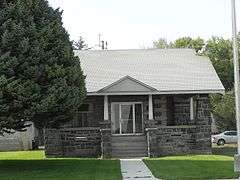
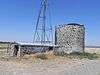
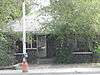
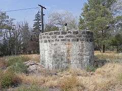
American Legion Hall |
|
000000001983-09-08-0000September 8, 1983
(#83002355) |
107 W. A St.
42°56′04″N 114°24′25″W / 42.934444°N 114.406944°W / 42.934444; -114.406944 (American Legion Hall) |
Shoshone |
|
| 2 |
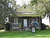
Jose and Gertrude Anasola House |
Upload image |
000000001983-09-08-0000September 8, 1983
(#83002356) |
120 N. Alta St.
42°56′13″N 114°24′11″W / 42.936944°N 114.403056°W / 42.936944; -114.403056 (Jose and Gertrude Anasola House) |
Shoshone |
|
| 3 |
Galo Arambarri Boarding House |
|
000000001983-09-08-0000September 8, 1983
(#83002357) |
109 N. Greenwood St.
42°56′15″N 114°24′17″W / 42.9375°N 114.404722°W / 42.9375; -114.404722 (Galo Arambarri Boarding House) |
Shoshone |
|
| 4 |
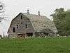
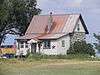
S.A. Bate Barn and Chicken House |
|
000000001983-09-08-0000September 8, 1983
(#83002358) |
Southeast of Dietrich
42°53′05″N 114°15′14″W / 42.884722°N 114.253889°W / 42.884722; -114.253889 (S.A. Bate Barn and Chicken House) |
Dietrich |
|
| 5 |
W. H. Baugh House |
Upload image |
000000001983-09-08-0000September 8, 1983
(#83002359) |
East of Shoshone
42°57′38″N 114°18′36″W / 42.960556°N 114.31°W / 42.960556; -114.31 (W. H. Baugh House) |
Shoshone |
|
| 6 |
Ignacio Berriochoa Farm |
Upload image |
000000001983-09-08-0000September 8, 1983
(#83002360) |
Northwest of Dietrich
42°55′10″N 114°18′03″W / 42.919444°N 114.300833°W / 42.919444; -114.300833 (Ignacio Berriochoa Farm) |
Dietrich |
|
| 7 |
Birdie Boussuet Farm |
Upload image |
000000001983-09-08-0000September 8, 1983
(#83002361) |
West of Richfield
43°01′54″N 114°11′24″W / 43.031667°N 114.19°W / 43.031667; -114.19 (Birdie Boussuet Farm) |
Richfield |
|
| 8 |
Tom Byrne House |
Upload image |
000000001983-09-08-0000September 8, 1983
(#83002362) |
Northeast of Shoshone
43°07′45″N 114°15′54″W / 43.129167°N 114.265°W / 43.129167; -114.265 (Tom Byrne House) |
Shoshone |
|
| 9 |
Custer Slaughter House |
Upload image |
000000001983-09-08-0000September 8, 1983
(#83002363) |
West of Shoshone
42°56′41″N 114°24′41″W / 42.944722°N 114.411389°W / 42.944722; -114.411389 (Custer Slaughter House) |
Shoshone |
|
| 10 |
Darrah House and Water Tank House |
Upload image |
000000001983-09-08-0000September 8, 1983
(#83002365) |
Northeast of Shoshone
42°58′55″N 114°21′32″W / 42.981944°N 114.358889°W / 42.981944; -114.358889 (Darrah House and Water Tank House) |
Shoshone |
|
| 11 |
Ben Darrah Water Tank and Well House |
|
000000001983-09-08-0000September 8, 1983
(#83002364) |
North of Shoshone
43°01′34″N 114°24′58″W / 43.026111°N 114.416111°W / 43.026111; -114.416111 (Ben Darrah Water Tank and Well House) |
Shoshone |
|
| 12 |
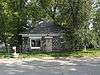
Charles W. Dill House |
|
000000001983-09-08-0000September 8, 1983
(#83002366) |
East of Shoshone
42°55′08″N 114°21′45″W / 42.918889°N 114.3625°W / 42.918889; -114.3625 (Charles W. Dill House) |
Shoshone |
|
| 13 |
Alvin Eskelton Barn |
Upload image |
000000001983-09-08-0000September 8, 1983
(#83002367) |
Northwest of Richfield
43°05′34″N 114°10′25″W / 43.092778°N 114.173611°W / 43.092778; -114.173611 (Alvin Eskelton Barn) |
Richfield |
|
| 14 |
George H. Gaches Cellar and Ice House |
Upload image |
000000001983-09-08-0000September 8, 1983
(#83002368) |
Northwest of Shoshone
43°01′07″N 114°26′43″W / 43.018611°N 114.445278°W / 43.018611; -114.445278 (George H. Gaches Cellar and Ice House) |
Shoshone |
|
| 15 |
Thomas Gooding Water Tank House |
Upload image |
000000001983-09-08-0000September 8, 1983
(#83002369) |
Northwest of Shoshone
43°01′32″N 114°30′55″W / 43.025556°N 114.515278°W / 43.025556; -114.515278 (Thomas Gooding Water Tank House) |
Shoshone |
|
| 16 |
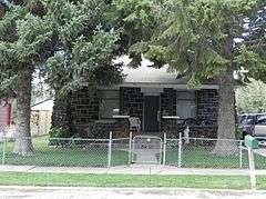
Gehrig Gottfried Cabin |
Upload image |
000000001983-09-08-0000September 8, 1983
(#83002370) |
Northwest of Shoshone
43°02′45″N 114°19′33″W / 43.045833°N 114.325833°W / 43.045833; -114.325833 (Gehrig Gottfried Cabin) |
Shoshone |
|
| 17 |
Daniel A. Hunt House |
|
000000001983-09-08-0000September 8, 1983
(#83002371) |
Southwest of Dietrich
42°52′06″N 114°17′41″W / 42.868333°N 114.294722°W / 42.868333; -114.294722 (Daniel A. Hunt House) |
Dietrich |
|
| 18 |
J.C. Penney Company Building |
|
000000001983-09-08-0000September 8, 1983
(#83002372) |
104 S. Rail St.
42°56′06″N 114°24′21″W / 42.935°N 114.405833°W / 42.935; -114.405833 (J.C. Penney Company Building) |
Shoshone |
|
| 19 |
Louis Johnson Barn |
Upload image |
000000001983-09-08-0000September 8, 1983
(#83002373) |
Southwest of Richfield
43°01′36″N 114°13′45″W / 43.026667°N 114.229167°W / 43.026667; -114.229167 (Louis Johnson Barn) |
Richfield |
|
| 20 |
Louis Johnson Water Tank House |
Upload image |
000000001983-09-08-0000September 8, 1983
(#83002374) |
West of Richfield
43°01′30″N 114°14′37″W / 43.025°N 114.243611°W / 43.025; -114.243611 (Louis Johnson Water Tank House) |
Richfield |
|
| 21 |
Quet Johnson Farm |
Upload image |
000000001983-09-08-0000September 8, 1983
(#83002375) |
Northwest of Richfield
43°05′55″N 114°10′10″W / 43.098611°N 114.169444°W / 43.098611; -114.169444 (Quet Johnson Farm) |
Richfield |
|
| 22 |
W.S. Kohl Barn |
Upload image |
000000001983-09-08-0000September 8, 1983
(#83002376) |
Northeast of Richfield
43°04′25″N 114°07′54″W / 43.073611°N 114.131667°W / 43.073611; -114.131667 (W.S. Kohl Barn) |
Richfield |
|
| 23 |
James H. Lane Barn |
|
000000001983-09-08-0000September 8, 1983
(#83002377) |
South of Richfield
43°02′33″N 114°09′07″W / 43.0425°N 114.151944°W / 43.0425; -114.151944 (James H. Lane Barn) |
Richfield |
|
| 24 |
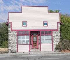
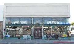
Lemmon Hardware Store |
Upload image |
000000001983-09-08-0000September 8, 1983
(#83002378) |
Main St. and Nez Perce Ave.
43°02′58″N 114°09′08″W / 43.049444°N 114.152222°W / 43.049444; -114.152222 (Lemmon Hardware Store) |
Richfield |
|
| 25 |
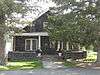
W.H. Murphy House |
|
000000001983-09-08-0000September 8, 1983
(#83002379) |
607 S. Greenwood St.
42°55′53″N 114°24′30″W / 42.931389°N 114.408333°W / 42.931389; -114.408333 (W.H. Murphy House) |
Shoshone |
|
| 26 |
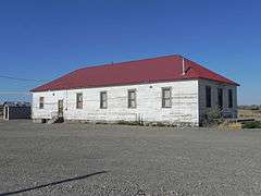
Myers School |
Upload image |
000000001983-09-08-0000September 8, 1983
(#83002380) |
West of Shoshone
42°57′28″N 114°29′20″W / 42.957778°N 114.488889°W / 42.957778; -114.488889 (Myers School) |
Shoshone |
|
| 27 |
A.G. Newman House |
|
000000001983-09-08-0000September 8, 1983
(#83002381) |
309 E. C St.
42°55′55″N 114°24′16″W / 42.931944°N 114.404444°W / 42.931944; -114.404444 (A.G. Newman House) |
Shoshone |
|
| 28 |
Thomas Olley House |
|
000000001983-09-08-0000September 8, 1983
(#83002382) |
522 N. Apple St.
42°56′28″N 114°24′20″W / 42.941111°N 114.405556°W / 42.941111; -114.405556 (Thomas Olley House) |
Shoshone |
|
| 29 |
Jack Oughton House |
|
000000001983-09-08-0000September 8, 1983
(#83002383) |
123 N. Beverly St.
42°56′13″N 114°24′08″W / 42.936944°N 114.402222°W / 42.936944; -114.402222 (Jack Oughton House) |
Shoshone |
|
| 30 |
Denton J. Paul Water Tank |
|
000000001983-09-08-0000September 8, 1983
(#83002384) |
East of Dietrich
42°54′31″N 114°14′28″W / 42.908611°N 114.241111°W / 42.908611; -114.241111 (Denton J. Paul Water Tank) |
Dietrich |
|
| 31 |
Kenneth G. Phelphs Barn |
Upload image |
000000001983-09-08-0000September 8, 1983
(#83002385) |
West of Richfield
43°02′58″N 114°10′25″W / 43.049444°N 114.173611°W / 43.049444; -114.173611 (Kenneth G. Phelphs Barn) |
Richfield |
|
| 32 |
Purdum Livery Stable |
Upload image |
000000001983-09-15-0000September 15, 1983
(#83002393) |
113 N. Rail St., E.
42°56′09″N 114°24′16″W / 42.935833°N 114.404444°W / 42.935833; -114.404444 (Purdum Livery Stable) |
Shoshone |
|
| 33 |
Richfield Pump House |
Upload image |
000000001983-09-08-0000September 8, 1983
(#83002386) |
Southeast of Richfield
43°02′30″N 114°09′01″W / 43.041667°N 114.150278°W / 43.041667; -114.150278 (Richfield Pump House) |
Richfield |
|
| 34 |
William M. Ritter House |
Upload image |
000000001983-09-08-0000September 8, 1983
(#83002387) |
Northeast of Shoshone
43°01′10″N 114°21′13″W / 43.019444°N 114.353611°W / 43.019444; -114.353611 (William M. Ritter House) |
Shoshone |
|
| 35 |
Shoshone Historic District |
Upload image |
000000001975-06-27-0000June 27, 1975
(#75000636) |
Irregular pattern, including the northern bank of the Little Wood River and W. D St.; also 115 N. Greenwood St.
42°56′02″N 114°24′28″W / 42.93387°N 114.40766°W / 42.93387; -114.40766 (Shoshone Historic District) |
Shoshone |
Greenwood St. address represents a boundary increase
|
| 36 |
Arthur D. Silva Flume |
Upload image |
000000001983-09-08-0000September 8, 1983
(#83002388) |
Northwest of Shoshone
42°59′26″N 114°26′59″W / 42.990556°N 114.449722°W / 42.990556; -114.449722 (Arthur D. Silva Flume) |
Shoshone |
|
| 37 |
Arthur D. Silva Ranch |
Upload image |
000000001983-09-08-0000September 8, 1983
(#83002389) |
Northwest of Shoshone
42°59′37″N 114°27′14″W / 42.993611°N 114.453889°W / 42.993611; -114.453889 (Arthur D. Silva Ranch) |
Shoshone |
|
| 38 |
Arthur D. Silva Water Tank |
Upload image |
000000001983-09-08-0000September 8, 1983
(#83002390) |
Northwest of Shoshone
42°59′43″N 114°27′14″W / 42.995278°N 114.453889°W / 42.995278; -114.453889 (Arthur D. Silva Water Tank) |
Shoshone |
|
| 39 |
Manuel Silva Barn |
|
000000001983-09-08-0000September 8, 1983
(#83002391) |
East of Shoshone
42°55′34″N 114°21′35″W / 42.926111°N 114.359722°W / 42.926111; -114.359722 (Manuel Silva Barn) |
Shoshone |
|
| 40 |
John G. Turner House |
Upload image |
000000001983-09-08-0000September 8, 1983
(#83002392) |
West of Richfield
43°00′20″N 114°14′23″W / 43.005556°N 114.239722°W / 43.005556; -114.239722 (John G. Turner House) |
Richfield |
|
| 41 |
Wood River Center Grange No. 87 |
|
000000002003-07-03-0000July 3, 2003
(#03000586) |
375 W. 4 Mile Rd.
43°00′12″N 114°28′43″W / 43.003333°N 114.478611°W / 43.003333; -114.478611 (Wood River Center Grange No. 87) |
Shoshone |
|