| [4] |
Name on the Register[5] |
Image |
Date listed[6] |
Location |
City or town |
Description |
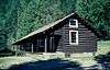
|---|
| 1 |
Ah Toy Garden |
Upload image |
000000001990-06-27-0000June 27, 1990
(#90000893) |
Along China Creek near its confluence with the South Fork of the Salmon River in the Payette National Forest
45°12′57″N 115°33′21″W / 45.215833°N 115.555833°W / 45.215833; -115.555833 (Ah Toy Garden) |
Warren vicinity |
|
| 2 |
Aitken Barn |
Upload image |
000000001982-08-09-0000August 9, 1982
(#82002512) |
Southwest of Riggins on U.S. Route 95
45°24′28″N 116°19′48″W / 45.407896°N 116.329933°W / 45.407896; -116.329933 (Aitken Barn) |
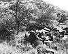
Riggins vicinity |
|
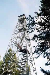
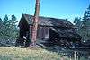
| 3 |
Arctic Point Fire Lookout |
|
000000001994-08-29-0000August 29, 1994
(#94001019) |
North of Big Creek in the Frank Church-River of No Return Wilderness and the Payette National Forest
45°28′28″N 115°02′19″W / 45.474373°N 115.038593°W / 45.474373; -115.038593 (Arctic Point Fire Lookout) |
Big Creek vicinity |
|
| 4 |
James V. and Sophia Baker House |
Upload image |
000000002004-01-06-0000January 6, 2004
(#03001366) |
204 Broadway St.
46°02′51″N 116°21′04″W / 46.047448°N 116.351135°W / 46.047448; -116.351135 (James V. and Sophia Baker House) |
Cottonwood |
|
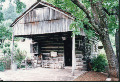
| 5 |
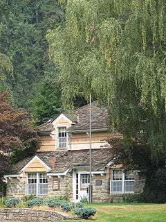
Polly Bemis House |
|
000000001988-03-04-0000March 4, 1988
(#87002152) |
Accessible on the Salmon River via boat
45°25′59″N 115°40′13″W / 45.433056°N 115.670278°W / 45.433056; -115.670278 (Polly Bemis House) |
Riggins |
|
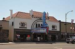
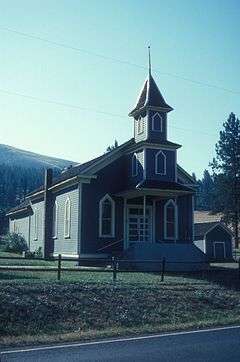
| 6 |
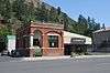
Blue Fox Theatre |
|
000000001999-11-30-0000November 30, 1999
(#99001412) |
116 W. Main St.
45°55′32″N 116°07′09″W / 45.925556°N 116.119167°W / 45.925556; -116.119167 (Blue Fox Theatre) |
Grangeville |
|
| 7 |
Burgdorf |
|
000000001972-04-14-0000April 14, 1972
(#72000441) |
About 15 miles west of Warrens
45°16′38″N 115°54′46″W / 45.277222°N 115.912778°W / 45.277222; -115.912778 (Burgdorf) |
Burgdorf |
|
| 8 |
Campbell's Ferry |
Upload image |
000000002007-02-08-0000February 8, 2007
(#07000037) |
Southeastern bank of the Salmon River at Mile 148 in the Frank Church-River of No Return Wilderness
45°29′11″N 115°20′03″W / 45.486252°N 115.334133°W / 45.486252; -115.334133 (Campbell's Ferry) |
Riggins |
|
| 9 |
Carey Dome Fire Lookout |
Upload image |
000000001994-03-25-0000March 25, 1994
(#94000268) |
Nez Perce National Forest, 9 miles north of United States Forest Service Burgdorf Guard Station
45°24′10″N 115°54′12″W / 45.402778°N 115.903333°W / 45.402778; -115.903333 (Carey Dome Fire Lookout) |
Burgdorf |
|
| 10 |
Celadon Slope Garden |
Upload image |
000000001990-06-27-0000June 27, 1990
(#90000891) |
Along China Creek near its confluence with the South Fork of the Salmon River in the Payette National Forest
45°12′58″N 115°34′15″W / 45.216111°N 115.570833°W / 45.216111; -115.570833 (Celadon Slope Garden) |
Warren |
|
| 11 |
Chamberlain Ranger Station Historic District |
Upload image |
000000002004-01-14-0000January 14, 2004
(#03001388) |
Frank Church-River of No Return Wilderness
45°22′32″N 115°12′02″W / 45.375556°N 115.200556°W / 45.375556; -115.200556 (Chamberlain Ranger Station Historic District) |
Payette National Forest |
|
| 12 |
Chi-Sandra Garden |
Upload image |
000000001990-06-27-0000June 27, 1990
(#90000892) |
Along China Creek near its confluence with the South Fork of the Salmon River in the Payette National Forest
45°12′52″N 115°33′50″W / 45.214444°N 115.563889°W / 45.214444; -115.563889 (Chi-Sandra Garden) |
Warren |
|
| 13 |
Chinese Cemetery |
Upload image |
000000001994-03-29-0000March 29, 1994
(#94000270) |
Payette National Forest, 0.5 miles northwest of Warren Wagon Rd. at B
45°16′22″N 115°41′06″W / 45.272778°N 115.685°W / 45.272778; -115.685 (Chinese Cemetery) |
Warren |
|
| 14 |
Chinese Mining Camp Archeological Site |
Upload image |
000000001994-09-04-0000September 4, 1994
(#94001018) |
Northwest of Warren in the Payette National Forest
45°16′14″N 115°41′34″W / 45.270556°N 115.692778°W / 45.270556; -115.692778 (Chinese Mining Camp Archeological Site) |
Warren |
|
| 15 |
Cold Meadows Guard Station |
Upload image |
000000001994-08-19-0000August 19, 1994
(#94001017) |
Northeast of McCall in the Frank Church-River of No Return Wilderness and the Payette National Forest
45°17′10″N 114°56′28″W / 45.286111°N 114.941111°W / 45.286111; -114.941111 (Cold Meadows Guard Station) |
McCall |
|
| 16 |
Deep Creek Ranger Station |
Upload image |
000000002013-12-11-0000December 11, 2013
(#13000902) |
West Fork Ranger District, Bitterroot National Forest
Coordinates missing |
Darby, Montana, vicinity |
|
| 17 |
Jurden Henry Elfers Barn and Field |
Upload image |
000000002007-06-07-0000June 7, 2007
(#07000544) |
South bank of John Day Creek, ⅓ mile east of U.S. Route 95
45°34′59″N 116°17′15″W / 45.582957°N 116.287626°W / 45.582957; -116.287626 (Jurden Henry Elfers Barn and Field) |
Lucile |
|
| 18 |
Elk City Wagon Road-Victory Gulch-Smith Grade Segment |
Upload image |
000000002001-05-21-0000May 21, 2001
(#01000536) |
Nez Perce National Forest
45°51′29″N 115°35′23″W / 45.858056°N 115.589722°W / 45.858056; -115.589722 (Elk City Wagon Road-Victory Gulch-Smith Grade Segment) |
Elk City |
|
| 19 |
Fenn Ranger Station |
|
000000001990-06-18-0000June 18, 1990
(#90000931) |
Selway Road 223 near Johnson Creek in the Nez Perce National Forest
46°06′06″N 115°32′41″W / 46.101667°N 115.544722°W / 46.101667; -115.544722 (Fenn Ranger Station) |
Kooskia |
|
| 20 |
First Presbyterian Church |
|
000000001976-05-13-0000May 13, 1976
(#76000674) |
Southeast of Kamiah on U.S. Route 12
46°12′15″N 116°00′24″W / 46.204286°N 116.006639°W / 46.204286; -116.006639 (First Presbyterian Church) |
Kamiah |
|
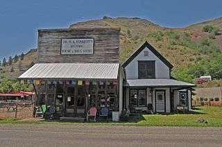
| 21 |
Dr. Wilson Foskett Home and Drugstore |
|
000000002005-04-26-0000April 26, 2005
(#05000337) |
West side of River Rd.
45°45′44″N 116°18′01″W / 45.762222°N 116.300278°W / 45.762222; -116.300278 (Dr. Wilson Foskett Home and Drugstore) |
White Bird |
|
| 22 |
Blacky Foster House |
Upload image |
000000001992-04-10-0000April 10, 1992
(#92000307) |
Along the Salmon River west of Shoup in the Bitterroot National Forest
45°29′10″N 114°58′29″W / 45.486111°N 114.974722°W / 45.486111; -114.974722 (Blacky Foster House) |
Shoup |
|
| 23 |
Gold Point Mill |
|
000000002000-07-14-0000July 14, 2000
(#00000792) |
United States Forest Service Road 222
45°46′56″N 115°23′33″W / 45.782222°N 115.3925°W / 45.782222; -115.3925 (Gold Point Mill) |
Elk City |
|
| 24 |
Hells Canyon Archeological District |
|
000000001984-08-10-0000August 10, 1984
(#84000984) |
Address Restricted[7]
|
Riggins |
Extends into Adams and Nez Perce counties and Wallowa County, Oregon
|
| 25 |
Lochsa Historical Ranger Station |
|
000000001978-06-09-0000June 9, 1978
(#78001065) |
Address Restricted[7]
|
Kooskia |
|
| 26 |
Lower Salmon River Archeological District |
|
000000001986-09-04-0000September 4, 1986
(#86002170) |
Address Restricted[7]
|
Cottonwood |
Extends into Lewis and Nez Perce counties
|
| 27 |
Sue McBeth Cabin |
|
000000001976-06-03-0000June 3, 1976
(#76000675) |
Southeast of Kamiah on U.S. Route 12
46°12′18″N 116°00′22″W / 46.205°N 116.006111°W / 46.205; -116.006111 (Sue McBeth Cabin) |
Kamiah |
|
| 28 |
Meinert Ranch Cabin |
Upload image |
000000001987-09-23-0000September 23, 1987
(#87001561) |
1.8 miles southwest of Red River Hot Springs on Red River-Beargrass Road 234
45°46′19″N 115°13′22″W / 45.771944°N 115.222778°W / 45.771944; -115.222778 (Meinert Ranch Cabin) |
Elk City |
|
| 29 |
Jim Moore Place |
Upload image |
000000001978-03-29-0000March 29, 1978
(#78001063) |
Salmon River Canyon
45°29′13″N 115°20′14″W / 45.486944°N 115.337222°W / 45.486944; -115.337222 (Jim Moore Place) |
Dixie |
|
| 30 |
Moose Creek Administrative Site |
Upload image |
000000001990-06-25-0000June 25, 1990
(#90000932) |
Eastern side of Moose Creek, south of Whistling Pig Creek, in the Nez Perce National Forest
46°06′40″N 114°55′15″W / 46.111111°N 114.920833°W / 46.111111; -114.920833 (Moose Creek Administrative Site) |
Grangeville |
|
| 31 |
Old China Trail |
Upload image |
000000001990-06-27-0000June 27, 1990
(#90000894) |
Along China Creek near its confluence with the South Fork of the Salmon River in the Payette National Forest
45°13′00″N 115°33′48″W / 45.216667°N 115.563333°W / 45.216667; -115.563333 (Old China Trail) |
Warren |
|
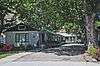
| 32 |
Riggins Motel |
|
000000002001-09-14-0000September 14, 2001
(#01000979) |
615 S. State Highway 95
45°25′05″N 116°19′02″W / 45.418056°N 116.317222°W / 45.418056; -116.317222 (Riggins Motel) |
Riggins |
|
| 33 |
St. Gertrude's Convent and Chapel |
Upload image |
000000001979-06-18-0000June 18, 1979
(#79000790) |
West of Cottonwood
46°02′01″N 116°23′25″W / 46.033611°N 116.390278°W / 46.033611; -116.390278 (St. Gertrude's Convent and Chapel) |
Cottonwood |
|
| 34 |
State Bank of Kooskia |
|
000000001978-05-22-0000May 22, 1978
(#78001067) |
1 S. Main St.
46°08′24″N 115°58′40″W / 46.14°N 115.977778°W / 46.14; -115.977778 (State Bank of Kooskia) |
Kooskia |
|
| 35 |
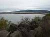
Tolo Lake |
|
000000002011-02-07-0000February 7, 2011
(#10001200) |
Tolo Lake Rd., Nez Perce National Historical Park
45°54′54″N 116°14′10″W / 45.915°N 116.236111°W / 45.915; -116.236111 (Tolo Lake) |
Grangeville vicinity |
Tolo Lake page on NPS website
|
| 36 |
Warren Guard Station, Building 1206 |
Upload image |
000000001994-04-07-0000April 7, 1994
(#94000271) |
Southwestern side of Warren Wagon Rd., United States Forest Service Highway 21
45°16′02″N 115°40′16″W / 45.267222°N 115.671111°W / 45.267222; -115.671111 (Warren Guard Station, Building 1206) |
Warren |
|
| 37 |
White Bird Battlefield |
|
000000001974-07-18-0000July 18, 1974
(#74000332) |
North of White Bird off U.S. Route 95
45°47′30″N 116°16′47″W / 45.791667°N 116.279722°W / 45.791667; -116.279722 (White Bird Battlefield) |
White Bird |
|
| 38 |
White Bird Grade |
|
000000001974-07-30-0000July 30, 1974
(#74000740) |
Northeast of White Bird
45°49′26″N 116°14′34″W / 45.823889°N 116.242778°W / 45.823889; -116.242778 (White Bird Grade) |
White Bird |
|