| [4] |
Name on the Register[5] |
Image |
Date listed[6] |
Location |
City or town |
Description |
|---|
| 1 |
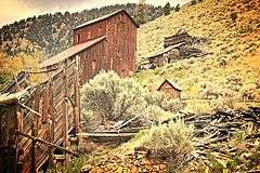
Bayhorse |
|
000000001976-03-15-0000March 15, 1976
(#76000671) |
South of Challis off U.S. Route 93
44°23′52″N 114°18′42″W / 44.397778°N 114.311667°W / 44.397778; -114.311667 (Bayhorse) |
Challis |
A silver mining ghost town, part of Land of the Yankee Fork State Park
|
| 2 |
Board-and-Batten Commercial Building |
Upload image |
000000001980-12-03-0000December 3, 1980
(#80001300) |
about 260 Main Ave.
44°30′19″N 114°14′09″W / 44.505278°N 114.235833°W / 44.505278; -114.235833 (Board-and-Batten Commercial Building) |
Challis |
Built c.1896, removed after June 2008
|
| 3 |
Building at 247 Pleasant Avenue |
Upload image |
000000001980-12-03-0000December 3, 1980
(#80001301) |
247 Pleasant Ave.
44°30′13″N 114°14′10″W / 44.503611°N 114.236111°W / 44.503611; -114.236111 (Building at 247 Pleasant Avenue) |
Challis |
|
| 4 |
Buster Meat Market |
Upload image |
000000001980-12-03-0000December 3, 1980
(#80004551) |
about 250 Main Ave.
44°30′19″N 114°14′10″W / 44.505278°N 114.236111°W / 44.505278; -114.236111 (Buster Meat Market) |
Challis |
Built in 1897, removed before June 2008
|
| 5 |
Bux's Place |
Upload image |
000000001980-12-03-0000December 3, 1980
(#80001302) |
321 Main Ave.
44°30′17″N 114°14′06″W / 44.504722°N 114.235°W / 44.504722; -114.235 (Bux's Place) |
Challis |
|
| 6 |
Challis Archeological Spring District |
|
000000001981-02-12-0000February 12, 1981
(#81000206) |
Address Restricted[7]
|
Challis |
|
| 7 |
Challis Bison Jump Site |
|
000000001975-09-05-0000September 5, 1975
(#75000628) |
Address Restricted[7]
|
Challis |
|
| 8 |
Challis Brewery Historic District |
Upload image |
000000001980-02-05-0000February 5, 1980
(#80001303) |
Challis Creek Rd.
44°30′28″N 114°13′38″W / 44.507778°N 114.227222°W / 44.507778; -114.227222 (Challis Brewery Historic District) |
Challis |
|
| 9 |
Challis Cold Storage |
Upload image |
000000001980-12-03-0000December 3, 1980
(#80001304) |
about 300 Main Ave.
44°30′19″N 114°14′07″W / 44.505278°N 114.235278°W / 44.505278; -114.235278 (Challis Cold Storage) |
Challis |
Built in 1881 for Idaho governor George L. Shoup, collapsed in the 1983 Borah Peak earthquake, killing two children
|
| 10 |
Challis High School |
Upload image |
000000001980-12-03-0000December 3, 1980
(#80001305) |
701 Main Ave.
44°30′17″N 114°13′52″W / 44.504722°N 114.231111°W / 44.504722; -114.231111 (Challis High School) |
Challis |
Built in 1922, irreparably damaged by the 1983 Borah Peak earthquake, demolished
|
| 11 |
Bill Chivers House |
Upload image |
000000001980-12-03-0000December 3, 1980
(#80001306) |
3rd St.
44°30′21″N 114°14′07″W / 44.505833°N 114.235278°W / 44.505833; -114.235278 (Bill Chivers House) |
Challis |
|
| 12 |
Thomas Chivers Cellar |
Upload image |
000000001980-12-03-0000December 3, 1980
(#80001307) |
Challis Creek Rd.
44°30′27″N 114°13′34″W / 44.5075°N 114.226111°W / 44.5075; -114.226111 (Thomas Chivers Cellar) |
Challis |
|
| 13 |
Thomas Chivers House |
Upload image |
000000001980-12-03-0000December 3, 1980
(#80001308) |
Challis Creek Rd.
44°30′27″N 114°13′52″W / 44.5075°N 114.231111°W / 44.5075; -114.231111 (Thomas Chivers House) |
Challis |
|
| 14 |
Custer County Jail |
Upload image |
000000001980-12-03-0000December 3, 1980
(#80001309) |
801 Main Ave., Rear
44°30′18″N 114°13′49″W / 44.505°N 114.230278°W / 44.505; -114.230278 (Custer County Jail) |
Challis |
|
| 15 |
Custer Historic District |
|
000000001981-02-03-0000February 3, 1981
(#81000207) |
Along Yankee Fork Road southwest of the city of Challis, within the Challis National Forest
44°23′15″N 114°41′45″W / 44.3875°N 114.695833°W / 44.3875; -114.695833 (Custer Historic District) |
Custer |
|
| 16 |
Ivan W. Day House |
Upload image |
000000001986-04-09-0000April 9, 1986
(#86000754) |
Boise Meridian
44°16′06″N 114°57′05″W / 44.268333°N 114.951389°W / 44.268333; -114.951389 (Ivan W. Day House) |
Stanley |
|
| 17 |
East Fork Lookout |
|
000000001976-09-27-0000September 27, 1976
(#76000672) |
Address Restricted[7]
|
Clayton |
|
| 18 |
False-Front Commercial Building |
Upload image |
000000001980-12-03-0000December 3, 1980
(#80001310) |
about 291 Main Ave.
44°30′17″N 114°14′09″W / 44.504722°N 114.235833°W / 44.504722; -114.235833 (False-Front Commercial Building) |
Challis |
|
| 19 |
Emmett Hosford House |
Upload image |
000000001980-12-03-0000December 3, 1980
(#80001311) |
3rd St.
44°30′22″N 114°14′07″W / 44.506111°N 114.235278°W / 44.506111; -114.235278 (Emmett Hosford House) |
Challis |
|
| 20 |
I.O.O.F. Hall |
Upload image |
000000001980-12-03-0000December 3, 1980
(#80001312) |
521 Main Ave.
44°30′17″N 114°13′59″W / 44.504722°N 114.233056°W / 44.504722; -114.233056 (I.O.O.F. Hall) |
Challis |
|
| 21 |
Idaho Mining and Smelter Company Store |
Upload image |
000000002006-02-01-0000February 1, 2006
(#05001601) |
One Ford St.
44°15′34″N 114°23′47″W / 44.259444°N 114.396389°W / 44.259444; -114.396389 (Idaho Mining and Smelter Company Store) |
Clayton |
|
| 22 |
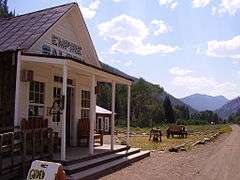
Idaho Rocky Mountain Club |
Upload image |
000000001994-12-09-0000December 9, 1994
(#94001451) |
State Highway 75 south of Stanley
44°05′46″N 114°50′54″W / 44.096111°N 114.848333°W / 44.096111; -114.848333 (Idaho Rocky Mountain Club) |
Stanley |
|
| 23 |
Mackay Episcopal Church |
Upload image |
000000001982-11-17-0000November 17, 1982
(#82000336) |
Park Ave. and College
43°54′40″N 113°36′47″W / 43.911111°N 113.613056°W / 43.911111; -113.613056 (Mackay Episcopal Church) |
Mackay |
|
| 24 |
Mackay Methodist Episcopal Church |
Upload image |
000000001984-09-07-0000September 7, 1984
(#84001118) |
Custer St. and Park Ave.
43°54′48″N 113°36′35″W / 43.913333°N 113.609722°W / 43.913333; -113.609722 (Mackay Methodist Episcopal Church) |
Mackay |
|
| 25 |
McKendrick House |
Upload image |
000000001980-12-03-0000December 3, 1980
(#80001313) |
4th St.
44°30′12″N 114°14′03″W / 44.503333°N 114.234167°W / 44.503333; -114.234167 (McKendrick House) |
Challis |
|
| 26 |
Niece Brothers' Store |
Upload image |
000000001995-06-12-0000June 12, 1995
(#95000667) |
Ace of Diamonds St.
44°12′59″N 114°56′17″W / 44.216389°N 114.938056°W / 44.216389; -114.938056 (Niece Brothers' Store) |
Stanley |
|
| 27 |
Old Challis Historic District |
Upload image |
000000001980-12-03-0000December 3, 1980
(#80001314) |
Bounded by Valley and Pleasant Aves., 2nd and 3rd Sts.
44°30′13″N 114°14′10″W / 44.503611°N 114.236111°W / 44.503611; -114.236111 (Old Challis Historic District) |
Challis |
|
| 28 |
Bill Peck House |
Upload image |
000000001980-12-03-0000December 3, 1980
(#80001315) |
16 Main Ave.
44°30′18″N 114°14′17″W / 44.505°N 114.238056°W / 44.505; -114.238056 (Bill Peck House) |
Challis |
|
| 29 |
Penwell House |
Upload image |
000000001980-12-03-0000December 3, 1980
(#80001316) |
North Ave.
44°30′23″N 114°13′50″W / 44.506389°N 114.230556°W / 44.506389; -114.230556 (Penwell House) |
Challis |
|
| 30 |
Redfish Archeological District |
|
000000001983-12-29-0000December 29, 1983
(#83003574) |
Address Restricted[7]
|
Stanley |
|
| 31 |
Donaldson Rowles House |
Upload image |
000000001980-12-03-0000December 3, 1980
(#80001317) |
North Ave.
44°30′22″N 114°13′23″W / 44.506111°N 114.223056°W / 44.506111; -114.223056 (Donaldson Rowles House) |
Challis |
|
| 32 |
Henry Smith House |
Upload image |
000000001980-12-03-0000December 3, 1980
(#80001318) |
5th St.
44°30′13″N 114°13′59″W / 44.503611°N 114.233056°W / 44.503611; -114.233056 (Henry Smith House) |
Challis |
|
| 33 |
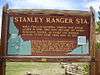
Stanley Ranger Station |
|
000000001982-12-15-0000December 15, 1982
(#82001885) |
South of Stanley on U.S. Route 93
44°13′33″N 114°55′44″W / 44.225833°N 114.928889°W / 44.225833; -114.928889 (Stanley Ranger Station) |
Stanley |
|
| 34 |
Stone and Log Building |
Upload image |
000000001980-12-03-0000December 3, 1980
(#80001320) |
Pleasant Ave.
44°30′16″N 114°14′06″W / 44.504444°N 114.235°W / 44.504444; -114.235 (Stone and Log Building) |
Challis |
|
| 35 |
Stone Building |
Upload image |
000000001980-12-03-0000December 3, 1980
(#80001319) |
3rd St.
44°30′20″N 114°14′07″W / 44.505556°N 114.235278°W / 44.505556; -114.235278 (Stone Building) |
Challis |
|
| 36 |
Twin Peaks Sports |
Upload image |
000000001980-12-03-0000December 3, 1980
(#80001321) |
500 Main Ave.
44°30′20″N 114°13′59″W / 44.505556°N 114.233056°W / 44.505556; -114.233056 (Twin Peaks Sports) |
Challis |
|
| 37 |
Clyde Wilkinson House |
Upload image |
000000001980-12-03-0000December 3, 1980
(#80001322) |
9th St.
44°30′25″N 114°13′46″W / 44.506944°N 114.229444°W / 44.506944; -114.229444 (Clyde Wilkinson House) |
Challis |
|