National Register of Historic Places listings in Lewis County, Washington
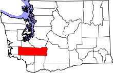
Location of Lewis County in Washington
This is a list of the National Register of Historic Places listings in Lewis County, Washington.
This is intended to be a complete list of the properties and districts on the National Register of Historic Places in Lewis County, Washington, United States. Latitude and longitude coordinates are provided for many National Register properties and districts; these locations may be seen together in a map.[1]
There are 34 properties and districts listed on the National Register in the county. Another 2 properties were once listed but have been removed.
- This National Park Service list is complete through NPS recent listings posted December 2, 2016.[2]
Current listings
| [3] | Name on the Register[4] | Image | Date listed[5] | Location | City or town | Description |
|---|---|---|---|---|---|---|
| 1 | George E. Birge House | 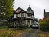 |
(#86003375) |
715 E St. 46°43′26″N 122°57′20″W / 46.723889°N 122.955556°W |
Centralia | |
| 2 | Boistfort High School | 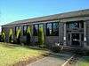 |
(#87001335) |
983 Boistfort Rd. 46°32′59″N 123°07′55″W / 46.549722°N 123.131944°W |
Curtis | Rural Public Schools of Washington State MPS |
| 3 | Joseph Borst House | 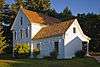 |
(#77001345) |
302 Bryden Ave. 46°43′13″N 122°58′55″W / 46.720278°N 122.981944°W |
Centralia | Architect: Jacob Ort |
| 4 | Burlington Northern Depot | 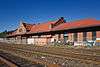 |
(#74001967) |
Off U.S. 99 46°40′18″N 122°58′16″W / 46.671667°N 122.971111°W |
Chehalis | Also known as Chehalis Passenger Station. Now it is the Lewis County Historical Museum. |
| 5 | Centralia Downtown Historic District | 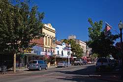 |
(#03000164) |
Roughly bounded by Center St., Burlington Northern right-of-way, Walnut st., and Pearl St. 46°43′02″N 122°57′13″W / 46.717222°N 122.953611°W |
Centralia | |
| 6 | Centralia Union Depot | 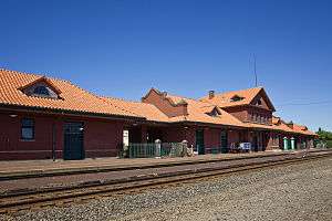 |
(#88000608) |
210 Railroad St. 46°43′04″N 122°57′08″W / 46.717778°N 122.952222°W |
Centralia | |
| 7 | Chehalis Downtown Historic District |  |
(#97001407) |
Roughly bounded by Park, and Front Sts., Washington and Cascade Aves. 46°39′56″N 122°58′08″W / 46.665556°N 122.968889°W |
Chehalis | |
| 8 | Claquato Church |  |
(#73001882) |
Off WA 12 46°38′35″N 123°01′13″W / 46.643056°N 123.020278°W |
Claquato | |
| 9 | Wesley Everest Gravesite | 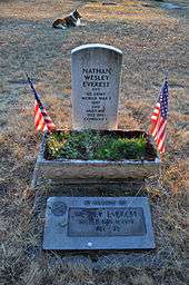 |
(#91001781) |
Sticklin-Greenwood Memorial Park, 1905 Johnson Rd. 46°44′11″N 122°58′51″W / 46.736389°N 122.980833°W |
Centralia | |
| 10 | Grace Evangelical Church of Vader | 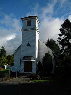 |
(#03000162) |
618 D St. 46°24′08″N 122°57′16″W / 46.402222°N 122.954444°W |
Vader | |
| 11 | Hillside Historic District |  |
(#96000841) |
Roughly bounded by Jefferson Ave., Hill St., Washington Ave., and 9th St. 46°39′42″N 122°57′39″W / 46.661667°N 122.960833°W |
Chehalis | |
| 12 | Holy Cross Polish National Catholic Church |  |
(#87001456) |
Third and Queen 46°34′04″N 123°17′57″W / 46.567778°N 123.299167°W |
Pe Ell | |
| 13 | Hubbard Bungalow |  |
(#05000922) |
717 N. Washington Ave. 46°43′30″N 122°57′39″W / 46.725°N 122.960833°W |
Centralia | |
| 14 | John R. Jackson House | 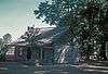 |
(#74001968) |
At Mary's Corner, 11 mi. S of Chehalis on Jackson Hwy. 46°32′32″N 122°49′13″W / 46.542222°N 122.820278°W |
Chehalis | |
| 15 | La Wis Wis Guard Station No. 1165 | 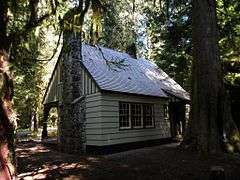 |
(#86000813) |
Gifford Pinchot National Forest 46°40′36″N 121°35′00″W / 46.676667°N 121.583333°W |
Packwood | |
| 16 | O. B. McFadden House | 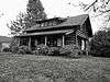 |
(#75001861) |
1639 Chehalis Ave. 46°39′29″N 122°57′54″W / 46.658056°N 122.965°W |
Chehalis | |
| 17 | Mineral Log Lodge | 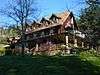 |
(#75001862) |
E side of Mineral Lake on Hill Rd. 46°43′20″N 122°10′52″W / 46.722222°N 122.181111°W |
Mineral | |
| 18 | Mount Rainier National Park | 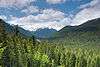 |
(#97000344) |
Longmire 46°52′59″N 121°53′04″W / 46.883056°N 121.884444°W |
Mount Rainier National Park | The park is a National Historic Landmark District, which includes 165 contributing structures and buildings.[6] |
| 19 | Lewis County Courthouse | 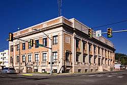 |
(#14000501) |
351 NW North St. 46°39′42″N 122°58′10″W / 46.661715°N 122.969327°W |
Chehalis | |
| 20 | North Fork Guard Station No. 1142 | 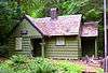 |
(#86000815) |
Gifford Pinchot National Forest 46°27′12″N 121°47′13″W / 46.453389°N 121.786896°W |
Randle vicinity | |
| 21 | Ohanapecosh Comfort Station No. O-302 | 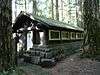 |
(#91000203) |
Mt. Rainier National Park 46°44′13″N 121°33′53″W / 46.736944°N 121.564722°W |
Ohanapecosh | |
| 22 | Ohanapecosh Comfort Station No. O-303 | 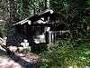 |
(#91000204) |
Mt. Rainier National Park 46°44′10″N 121°34′01″W / 46.736111°N 121.566944°W |
Ohanapecosh | |
| 23 | Ben Olsen House | 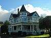 |
(#76001897) |
S end of D St. 46°23′48″N 122°57′16″W / 46.396667°N 122.954444°W |
Vader | |
| 24 | Olympic Club Saloon | 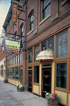 |
(#80004006) |
112 N. Tower St. 46°43′01″N 122°57′06″W / 46.716944°N 122.951667°W |
Centralia | |
| 25 | O. K. Palmer House | 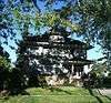 |
(#86001067) |
673 N.W. Pennsylvania 46°40′03″N 122°58′31″W / 46.6675°N 122.975278°W |
Chehalis | |
| 26 | Pennsylvania Avenue-West Side Historic District |  |
(#91001721) |
600 block NW. St. Helens and 440-723 Pennsylvania Aves. 46°39′57″N 122°58′30″W / 46.665833°N 122.975°W |
Chehalis | |
| 27 | Randle Ranger Station-Work Center | 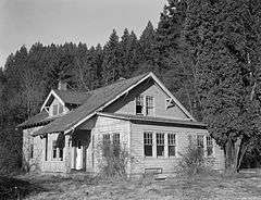 |
(#86000816) |
Gifford Pinchot National Forest 46°32′08″N 121°57′28″W / 46.535556°N 121.957778°W |
Randle | |
| 28 | Scout Lodge | 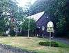 |
(#04001007) |
278 SE Adams Ave. 46°39′47″N 122°57′34″W / 46.663056°N 122.959444°W |
Chehalis | |
| 29 | St. Helens Hotel | 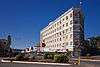 |
(#91001497) |
440 N. Market Blvd. 46°39′53″N 122°58′02″W / 46.664722°N 122.967222°W |
Chehalis | |
| 30 | The Sentinel | 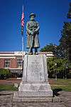 |
(#91001782) |
Washington Park, bounded by Main, Pearl, Locust and Silver 46°42′59″N 122°57′19″W / 46.716389°N 122.955278°W |
Centralia | Sculptor — Alonzo Victor Lewis |
| 31 | Three Lakes Patrol Cabin | Upload image | (#91000189) |
Mt. Rainier National Park 46°45′51″N 121°28′21″W / 46.764167°N 121.4725°W |
Ohanapecosh | |
| 32 | U.S. Post Office – Centralia Main | 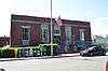 |
(#91000640) |
214 W. Centralia College Blvd.[7] 46°42′56″N 122°57′25″W / 46.7156°N 122.9570°W |
Centralia | |
| 33 | U.S. Post Office – Chehalis Main | 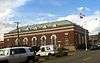 |
(#91000641) |
225 NW Cascade Ave.[8] 46°39′47″N 122°57′59″W / 46.663056°N 122.966389°W |
Chehalis | |
| 34 | Wolfenbarger Site | Upload image | (#77001346) |
Address Restricted |
Curtis |
Former listings
| [3] | Name on the Register | Image | Date listed | Date removed | Location | City or town | Summary |
|---|---|---|---|---|---|---|---|
| 1 | Doty Bridge | Upload image | (#82004260) | Spanning the Chehalis River |
Doty | ||
| 2 | Weyerhaeuser Pe Ell Bridge | 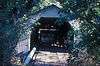 |
(#82004261) | South of Pe Ell, spanning the Chehalis River |
Pe Ell |
See also
- List of National Historic Landmarks in Washington
- National Register of Historic Places listings in Washington state
References
| Wikimedia Commons has media related to National Register of Historic Places in Lewis County, Washington. |
- ↑ The latitude and longitude information provided in this table was derived originally from the National Register Information System, which has been found to be fairly accurate for about 99% of listings. For about 1% of NRIS original coordinates, experience has shown that one or both coordinates are typos or otherwise extremely far off; some corrections may have been made. A more subtle problem causes many locations to be off by up to 150 yards, depending on location in the country: most NRIS coordinates were derived from tracing out latitude and longitudes off of USGS topographical quadrant maps created under the North American Datum of 1927, which differs from the current, highly accurate WGS84 GPS system used by most on-line maps. Chicago is about right, but NRIS longitudes in Washington are higher by about 4.5 seconds, and are lower by about 2.0 seconds in Maine. Latitudes differ by about 1.0 second in Florida. Some locations in this table may have been corrected to current GPS standards.
- ↑ "National Register of Historic Places: Weekly List Actions". National Park Service, United States Department of the Interior. Retrieved on December 2, 2016.
- 1 2 Numbers represent an ordering by significant words. Various colorings, defined here, differentiate National Historic Landmarks and historic districts from other NRHP buildings, structures, sites or objects.
- ↑ National Park Service (2008-04-24). "National Register Information System". National Register of Historic Places. National Park Service.
- ↑ The eight-digit number below each date is the number assigned to each location in the National Register Information System database, which can be viewed by clicking the number.
- ↑ "Mount Rainier Historic Structures". Retrieved 2008-02-23.
- ↑ Address based on USPS website. Accessed April 12, 2016.
- ↑ Address based on USPS website. Accessed April 12, 2016.

| Topics | |
|---|---|
| Lists by states |
|
| Lists by insular areas | |
| Lists by associated states | |
| Other areas | |
| |
Municipalities and communities of Lewis County, Washington, United States | ||
|---|---|---|
| Cities | | |
| Town | ||
| CDPs | ||
| Other unincorporated communities | ||
| Ghost towns | ||
This article is issued from Wikipedia - version of the 4/30/2016. The text is available under the Creative Commons Attribution/Share Alike but additional terms may apply for the media files.