| [3] |
Name on the Register[4] |
Image |
Date listed[5] |
Location |
City or town |
Description |
|---|
| 1 |
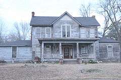
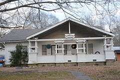
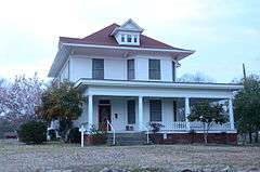
Amis House |
|
000000001983-10-28-0000October 28, 1983
(#83003460) |
2nd St.
33°48′40″N 92°24′56″W / 33.811111°N 92.415556°W / 33.811111; -92.415556 (Amis House) |
Fordyce |
|
| 2 |
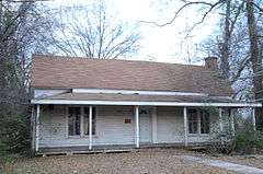
Henry Atchley House |
|
000000001983-10-28-0000October 28, 1983
(#83003461) |
Off Highway 8
34°02′09″N 92°53′09″W / 34.035833°N 92.885833°W / 34.035833; -92.885833 (Henry Atchley House) |
Dalark |
|
| 3 |
Bank of Carthage |
|
000000001982-12-22-0000December 22, 1982
(#82000806) |
Highway 229
34°04′27″N 92°33′16″W / 34.074167°N 92.554444°W / 34.074167; -92.554444 (Bank of Carthage) |
Carthage |
|
| 4 |
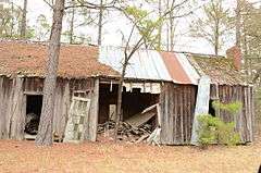
Bird Kiln |
Upload image |
000000001975-05-29-0000May 29, 1975
(#75000381) |
6 miles southwest of Leola off Highway 9
34°07′38″N 92°40′36″W / 34.127222°N 92.676667°W / 34.127222; -92.676667 (Bird Kiln) |
Leola |
|
| 5 |
Brazeale Homestead |
|
000000001983-10-28-0000October 28, 1983
(#83003463) |
Southeast of Highway 128
33°51′19″N 92°45′56″W / 33.855278°N 92.765556°W / 33.855278; -92.765556 (Brazeale Homestead) |
Pine Grove |
|
| 6 |
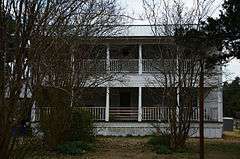
Butler-Matthews Homestead |
|
000000001983-10-28-0000October 28, 1983
(#83003465) |
Southwest of Tulip off Highway 9
34°04′28″N 92°39′22″W / 34.074444°N 92.656111°W / 34.074444; -92.656111 (Butler-Matthews Homestead) |
Tulip |
|
| 7 |
Charlotte Street Historic District |
|
000000001987-09-14-0000September 14, 1987
(#87001348) |
Roughly bounded by Holmes, Charlotte, Broadway, and E. College Sts.
33°49′00″N 92°24′27″W / 33.816667°N 92.4075°W / 33.816667; -92.4075 (Charlotte Street Historic District) |
Fordyce |
|
| 8 |
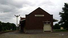
Cotton Belt Railroad Depot-Fordyce |
|
000000001992-06-11-0000June 11, 1992
(#92000608) |
Southwestern corner of the junction of Main and 1st Sts.
33°48′39″N 92°24′43″W / 33.810833°N 92.411944°W / 33.810833; -92.411944 (Cotton Belt Railroad Depot-Fordyce) |
Fordyce |
1925 railroad depot with Mediterranean influences
|
| 9 |
Culbertson Kiln |
Upload image |
000000001975-05-29-0000May 29, 1975
(#75000382) |
East of Princeton on Stark Bland Rd.
34°00′41″N 92°35′10″W / 34.011389°N 92.586111°W / 34.011389; -92.586111 (Culbertson Kiln) |
Princeton |
|
| 10 |
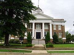
Dallas County Courthouse |
|
000000001984-03-27-0000March 27, 1984
(#84000677) |
3rd and Oak Sts.
33°48′45″N 92°24′49″W / 33.8125°N 92.413611°W / 33.8125; -92.413611 (Dallas County Courthouse) |
Fordyce |
|
| 11 |
Dallas County Training School High School Building |
|
000000002004-01-21-0000January 21, 2004
(#03001455) |
934 Center St.
33°49′01″N 92°24′07″W / 33.816944°N 92.401944°W / 33.816944; -92.401944 (Dallas County Training School High School Building) |
Fordyce |
|
| 12 |
Elliott House |
|
000000001984-03-27-0000March 27, 1984
(#84000681) |
309 Pine St.
33°48′41″N 92°25′02″W / 33.811389°N 92.417222°W / 33.811389; -92.417222 (Elliott House) |
Fordyce |
|
| 13 |
Fielder House |
Upload image |
000000001983-10-28-0000October 28, 1983
(#83003467) |
U.S. Route 79 Business
33°48′45″N 92°25′47″W / 33.8125°N 92.429722°W / 33.8125; -92.429722 (Fielder House) |
Fordyce |
|
| 14 |
First Presbyterian Church |
|
000000001983-10-28-0000October 28, 1983
(#83003468) |
U.S. Route 79 Business
33°48′47″N 92°24′53″W / 33.813056°N 92.414722°W / 33.813056; -92.414722 (First Presbyterian Church) |
Fordyce |
|
| 15 |
First United Methodist Church |
|
000000001983-10-28-0000October 28, 1983
(#83003469) |
E. 4th and Spring Sts.
33°48′51″N 92°24′44″W / 33.814167°N 92.412222°W / 33.814167; -92.412222 (First United Methodist Church) |
Fordyce |
|
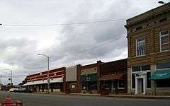
| 16 |
Fordyce Commercial Historic District |
|
000000002008-05-20-0000May 20, 2008
(#08000436) |
Roughly bounded by Oak, 5th, and Spring Sts., and Highway 274
33°48′47″N 92°24′45″W / 33.81297°N 92.4124°W / 33.81297; -92.4124 (Fordyce Commercial Historic District) |
Fordyce |
c.1884-1958 commercial core of Fordyce
|
| 17 |
Fordyce Home Accident Ins. Co. |
|
000000001982-12-22-0000December 22, 1982
(#82000807) |
300 Main
33°48′47″N 92°24′43″W / 33.813056°N 92.411944°W / 33.813056; -92.411944 (Fordyce Home Accident Ins. Co.) |
Fordyce |
|
| 18 |
Garrison Place |
Upload image |
000000001983-10-28-0000October 28, 1983
(#83003470) |
South of Highway 48
34°05′13″N 92°27′54″W / 34.086944°N 92.465°W / 34.086944; -92.465 (Garrison Place) |
Carthage |
Demolished
|
| 19 |
Capt. Goodgame House |
|
000000001983-10-28-0000October 28, 1983
(#83003471) |
Highway 128
33°49′11″N 92°42′52″W / 33.819722°N 92.714444°W / 33.819722; -92.714444 (Capt. Goodgame House) |
Holly Springs |
|
| 20 |
Hampton Springs Cemetery (Black Section) |
Upload image |
000000001983-10-28-0000October 28, 1983
(#83003473) |
Off Highway 48
34°05′21″N 92°29′24″W / 34.089167°N 92.49°W / 34.089167; -92.49 (Hampton Springs Cemetery (Black Section)) |
Carthage |
|
| 21 |
Ed Knight House |
|
000000001983-10-28-0000October 28, 1983
(#83003524) |
Off Highway 128
33°51′55″N 92°47′23″W / 33.865278°N 92.789722°W / 33.865278; -92.789722 (Ed Knight House) |
Pine Grove |
|
| 22 |
George W. Mallett House |
Upload image |
000000001983-10-28-0000October 28, 1983
(#83003526) |
Off Highway 8
33°58′41″N 92°37′34″W / 33.978056°N 92.626111°W / 33.978056; -92.626111 (George W. Mallett House) |
Princeton |
|
| 23 |
Marathon Oil Service Station |
|
000000002001-05-10-0000May 10, 2001
(#01000484) |
E. 2nd and Spring St.
33°48′43″N 92°24′43″W / 33.811944°N 92.411944°W / 33.811944; -92.411944 (Marathon Oil Service Station) |
Fordyce |
|
| 24 |
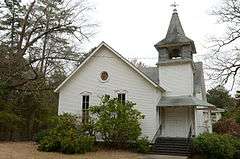
Mt. Carmel Methodist Church |
|
000000001983-10-28-0000October 28, 1983
(#83003528) |
Highway 9
33°54′13″N 92°38′15″W / 33.903611°N 92.6375°W / 33.903611; -92.6375 (Mt. Carmel Methodist Church) |
Jacinto |
|
| 25 |
Mt. Zion Methodist Church |
|
000000001983-10-28-0000October 28, 1983
(#83003529) |
Northeast of Carthage
34°06′32″N 92°31′15″W / 34.108922°N 92.520824°W / 34.108922; -92.520824 (Mt. Zion Methodist Church) |
Carthage |
|
| 26 |
Nutt-Trussell Building |
|
000000002001-03-04-0000March 4, 2001
(#01000110) |
202 N. Main St.
33°48′44″N 92°24′41″W / 33.812222°N 92.411389°W / 33.812222; -92.411389 (Nutt-Trussell Building) |
Fordyce |
|
| 27 |
Princeton Cemetery |
|
000000001984-03-27-0000March 27, 1984
(#84000872) |
Off Highway 9
33°58′34″N 92°37′01″W / 33.976111°N 92.616944°W / 33.976111; -92.616944 (Princeton Cemetery) |
Princeton |
|
| 28 |
Prosperity Baptist Church |
|
000000002003-05-22-0000May 22, 2003
(#03000421) |
Highway 8, W.
33°52′29″N 92°33′09″W / 33.874722°N 92.5525°W / 33.874722; -92.5525 (Prosperity Baptist Church) |
Ramsey |
|
| 29 |
Rock Island Railway Depot |
|
000000001983-10-28-0000October 28, 1983
(#83003534) |
3rd St.
33°48′49″N 92°24′36″W / 33.813611°N 92.41°W / 33.813611; -92.41 (Rock Island Railway Depot) |
Fordyce |
|
| 30 |
John Russell House |
|
000000001983-10-28-0000October 28, 1983
(#83003535) |
904 Charlotte St.
33°49′08″N 92°24′29″W / 33.818889°N 92.408056°W / 33.818889; -92.408056 (John Russell House) |
Fordyce |
|
| 31 |
Sardis Methodist Church |
|
000000001983-10-28-0000October 28, 1983
(#83003540) |
Northeast of Pine Grove off Highway 128
33°53′42″N 92°46′09″W / 33.895°N 92.769167°W / 33.895; -92.769167 (Sardis Methodist Church) |
Sparkman |
|
| 32 |
Jessie B. Smith House |
|
000000001983-10-28-0000October 28, 1983
(#83003541) |
Off U.S. Route 79
33°48′52″N 92°24′27″W / 33.814444°N 92.4075°W / 33.814444; -92.4075 (Jessie B. Smith House) |
Fordyce |
|
| 33 |
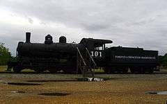
Tennessee, Alabama & Georgia Railway Steam Locomotive #101 |
|
000000002008-01-24-0000January 24, 2008
(#07001425) |
Northwest of the junction of N. Main St. and the Union Pacific railroad line
33°48′46″N 92°24′42″W / 33.812778°N 92.411667°W / 33.812778; -92.411667 (Tennessee, Alabama & Georgia Railway Steam Locomotive #101) |
Fordyce |
1922 locomotive
|
| 34 |
Thomas Homestead |
|
000000001984-03-27-0000March 27, 1984
(#84000895) |
Off Highway 7
33°59′05″N 92°51′17″W / 33.984722°N 92.854722°W / 33.984722; -92.854722 (Thomas Homestead) |
Fairview |
|
| 35 |
Tulip Cemetery |
|
000000001983-10-28-0000October 28, 1983
(#83003543) |
Off Highway 9
34°04′40″N 92°39′28″W / 34.077778°N 92.657778°W / 34.077778; -92.657778 (Tulip Cemetery) |
Tulip |
|
| 36 |
Waters House |
|
000000001982-12-22-0000December 22, 1982
(#82000808) |
515 Oak St.
33°48′51″N 92°24′54″W / 33.814167°N 92.415°W / 33.814167; -92.415 (Waters House) |
Fordyce |
|
| 37 |
Welch Pottery Works |
Upload image |
000000001975-05-12-0000May 12, 1975
(#75000383) |
Address Restricted
|
Tulip |
|
| 38 |
Wommack Kiln |
Upload image |
000000001975-06-10-0000June 10, 1975
(#75000384) |
Southeast of Wave on Wave Rd.
34°01′10″N 92°40′56″W / 34.019444°N 92.682222°W / 34.019444; -92.682222 (Wommack Kiln) |
Wave |
|
| 39 |
Wynne House |
|
000000001983-10-28-0000October 28, 1983
(#83003544) |
4th St.
33°48′45″N 92°25′00″W / 33.8125°N 92.416667°W / 33.8125; -92.416667 (Wynne House) |
Fordyce |
|