| [3] |
Name on the Register[4] |
Image |
Date listed[5] |
Location |
City or town |
Description |
|---|
| 1 |
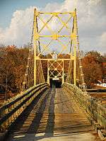
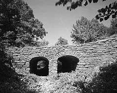
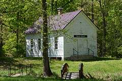
Beaver Bridge |
|
000000001990-04-09-0000April 9, 1990
(#90000730) |
Highway 187, over the White River
36°28′15″N 93°46′06″W / 36.470833°N 93.768333°W / 36.470833; -93.768333 (Beaver Bridge) |
Beaver |
|
| 2 |
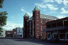
Berryville Agriculture Building |
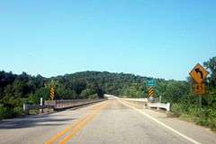
|
000000001992-09-10-0000September 10, 1992
(#92001214) |
South of Freeman Ave., east of Linda St., north of W. College Ave., and west of Ferguson St.
36°22′07″N 93°34′33″W / 36.368611°N 93.575833°W / 36.368611; -93.575833 (Berryville Agriculture Building) |
Berryville |
|
| 3 |
Berryville Commercial Historic District |
|
000000002016-03-24-0000March 24, 2016
(#16000402) |
Public Square
36°21′52″N 93°34′03″W / 36.364583°N 93.567447°W / 36.364583; -93.567447 (Berryville Commercial Historic District) |
Berryville |
|
| 4 |
Berryville Gymnasium |
|
000000001992-09-10-0000September 10, 1992
(#92001215) |
South of Freeman Ave., east of Linda St., north of W. College Ave., and west of Ferguson St.
36°22′08″N 93°34′33″W / 36.368889°N 93.575833°W / 36.368889; -93.575833 (Berryville Gymnasium) |
Berryville |
|
| 5 |
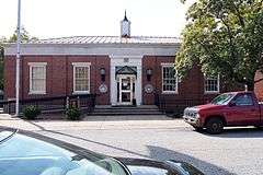
Berryville Post Office |
|
000000001998-08-14-0000August 14, 1998
(#98000922) |
101 E. Madison Ave.
36°21′52″N 93°33′56″W / 36.364444°N 93.565556°W / 36.364444; -93.565556 (Berryville Post Office) |
Berryville |
|
| 6 |
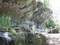
Blue Spring Shelter |
|
000000002002-12-20-0000December 20, 2002
(#02001596) |
Blue Spring Heritage Center, CR 210
36°24′10″N 93°44′11″W / 36.402778°N 93.736389°W / 36.402778; -93.736389 (Blue Spring Shelter) |
Eureka Springs |
Native American prehistoric site
|
| 7 |
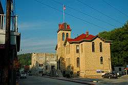
Carroll County Courthouse, Eastern District |
|
000000001976-08-27-0000August 27, 1976
(#76000392) |
Public Sq.
36°21′51″N 93°34′04″W / 36.364167°N 93.567778°W / 36.364167; -93.567778 (Carroll County Courthouse, Eastern District) |
Berryville |
|
| 8 |
Carroll County Poor Farm Cemetery |
Upload image |
000000002006-05-24-0000May 24, 2006
(#06000412) |
Address Restricted
|
Pleasant Valley |
|
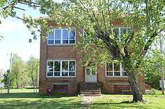
| 9 |
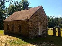
Concord School House |
|
000000002009-03-09-0000March 9, 2009
(#08001334) |
805 County Road 309
36°23′13″N 93°40′57″W / 36.386842°N 93.682375°W / 36.386842; -93.682375 (Concord School House) |
Eureka Springs |
|
| 10 |
W.D. Crawford House |
|
000000001992-11-20-0000November 20, 1992
(#92001613) |
East of County Road 27, about 1 mile north of its junction with County Road 98
36°23′00″N 93°29′48″W / 36.383333°N 93.496667°W / 36.383333; -93.496667 (W.D. Crawford House) |
Cisco |
|
| 11 |
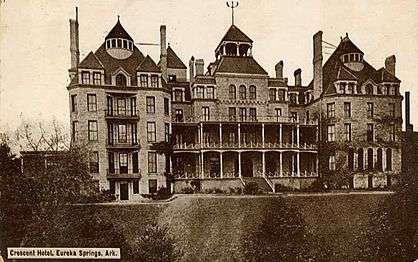
Crescent Hotel |
|
000000002016-01-26-0000January 26, 2016
(#15000991) |
75 Prospect Ave.
36°24′30″N 93°44′15″W / 36.408429°N 93.737509°W / 36.408429; -93.737509 (Crescent Hotel) |
Eureka Springs |
|
| 12 |
Dog Branch School |
|
000000001992-09-08-0000September 8, 1992
(#92001177) |
South of U.S. Highway 412, approximately 3 miles east of Osage
36°12′12″N 93°21′28″W / 36.203333°N 93.357778°W / 36.203333; -93.357778 (Dog Branch School) |
Osage |
|
| 13 |
Eureka Springs Historic District |
|
000000001970-12-18-0000December 18, 1970
(#70000118) |
Most of Eureka Springs and its environs; also S. Main
36°24′06″N 93°44′18″W / 36.401667°N 93.738333°W / 36.401667; -93.738333 (Eureka Springs Historic District) |
Eureka Springs |
South Main represents a boundary increase of 000000001979-01-29-0000January 29, 1979
|
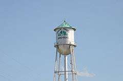
| 14 |
Green Forest Water Tower |
|
000000002007-05-22-0000May 22, 2007
(#07000470) |
Southeast of the junction of S. Springfield St. and E. 2nd St.
36°20′11″N 93°26′08″W / 36.336389°N 93.435556°W / 36.336389; -93.435556 (Green Forest Water Tower) |
Green Forest |
|
| 15 |
Lake Leatherwood Park Historic District |
|
000000001998-11-24-0000November 24, 1998
(#98001346) |
Between U.S. Highway 62 and Highway 23 at Leatherwood Lake
36°26′07″N 93°45′37″W / 36.435278°N 93.760278°W / 36.435278; -93.760278 (Lake Leatherwood Park Historic District) |
Eureka Springs |
|
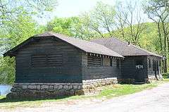
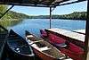
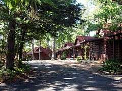
| 16 |
Lake Leatherwood Recreational Facilities |
|
000000001992-08-12-0000August 12, 1992
(#90001942) |
End of County Road 61
36°26′04″N 93°45′34″W / 36.434444°N 93.759444°W / 36.434444; -93.759444 (Lake Leatherwood Recreational Facilities) |
Eureka Springs |
|
| 17 |
Mo-Ark Baptist Academy |
|
000000001996-09-27-0000September 27, 1996
(#96001030) |
South of the western terminus of Park St.
36°29′52″N 93°23′57″W / 36.497778°N 93.399167°W / 36.497778; -93.399167 (Mo-Ark Baptist Academy) |
Blue Eye |
|
| 18 |
Mulladay Hollow Bridge |
|
000000001990-04-06-0000April 6, 1990
(#90000531) |
County Road 61, over Mulladay Hollow Creek
36°26′06″N 93°45′56″W / 36.435°N 93.765556°W / 36.435; -93.765556 (Mulladay Hollow Bridge) |
Eureka Springs |
|
| 19 |
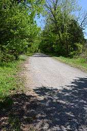
Old U.S. 62, Busch Segment |
|
000000002008-09-25-0000September 25, 2008
(#08000942) |
County Roads 107, 109, and 173
36°26′55″N 93°49′47″W / 36.448631°N 93.829678°W / 36.448631; -93.829678 (Old U.S. 62, Busch Segment) |
Busch |
|
| 20 |
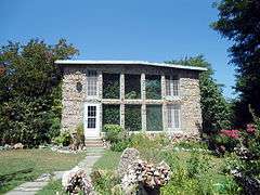
Quigley's Castle |
|
000000002003-05-30-0000May 30, 2003
(#03000467) |
274 Quigley's Castle Rd.
36°20′46″N 93°45′21″W / 36.346111°N 93.755833°W / 36.346111; -93.755833 (Quigley's Castle) |
Eureka Springs |
|
| 21 |
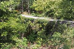
Sanitarium Lake Bridges Historic District |
|
000000002010-01-19-0000January 19, 2010
(#09001238) |
County Road 317, approximately 0.5 miles south of Greenwood Hollow Rd.
36°22′30″N 93°44′02″W / 36.375128°N 93.733958°W / 36.375128; -93.733958 (Sanitarium Lake Bridges Historic District) |
Eureka Springs |
|
| 22 |
Shady Grove Delmar Church and School |
|
000000002015-01-27-0000January 27, 2015
(#14001197) |
Cty. Rd. 933, 1.4 mi. W. of Delmar
36°10′07″N 93°21′44″W / 36.1685°N 93.3622°W / 36.1685; -93.3622 (Shady Grove Delmar Church and School) |
Delmar vicinity |
|
| 23 |
Stamps Store |
|
000000001990-09-05-0000September 5, 1990
(#90001380) |
AR 103 south of U.S. Highway 412
36°10′58″N 93°24′16″W / 36.182778°N 93.404444°W / 36.182778; -93.404444 (Stamps Store) |
Osage |
|
| 24 |
Tall Pines Motor Inn |
|
000000001999-01-15-0000January 15, 1999
(#98001603) |
U.S. Highway 62
36°24′18″N 93°45′08″W / 36.405°N 93.752222°W / 36.405; -93.752222 (Tall Pines Motor Inn) |
Eureka Springs |
|
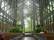
| 25 |
Thorncrown Chapel |
|
000000002000-04-28-0000April 28, 2000
(#97000452) |
U.S. Highway 62, 0.5 miles west of Eureka Springs
36°25′01″N 93°46′13″W / 36.416944°N 93.770278°W / 36.416944; -93.770278 (Thorncrown Chapel) |
Eureka Springs |
|
| 26 |
U.S. 62 White River Bridge |
|
000000002008-01-24-0000January 24, 2008
(#07001421) |
U.S. Highway 62, approximately ¼ mile south of County Road 212
36°27′04″N 93°49′24″W / 36.451111°N 93.823333°W / 36.451111; -93.823333 (U.S. 62 White River Bridge) |
Eureka Springs |
|
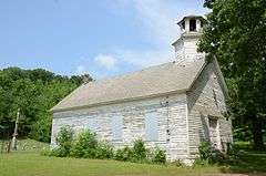
| 27 |
Winona Church and School |
|
000000001991-06-05-0000June 5, 1991
(#91000688) |
Rockhouse Rd.
36°19′58″N 93°40′54″W / 36.332778°N 93.681667°W / 36.332778; -93.681667 (Winona Church and School) |
Winona Springs |
|
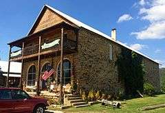
| 28 |
Yell Masonic Lodge Hall |
|
000000001984-11-01-0000November 1, 1984
(#84000178) |
CR 912, off U.S. Route 412
36°15′49″N 93°19′19″W / 36.263580°N 93.322017°W / 36.263580; -93.322017 (Yell Masonic Lodge Hall) |
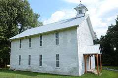
Carrollton |
Two story wood frame meeting house built in 1876. |