| [3] |
Name on the Register[4] |
Image |
Date listed[5] |
Location |
City or town |
Description |
|---|
| 1 |
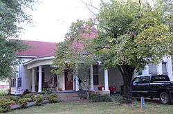
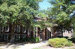
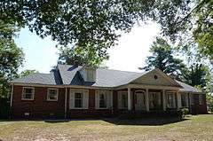
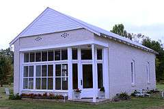
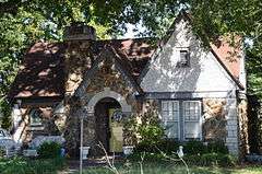
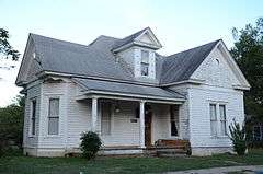
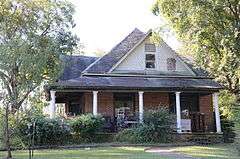
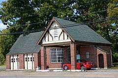
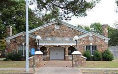
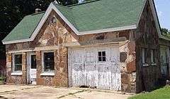
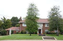
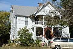
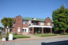
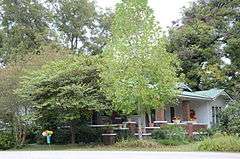
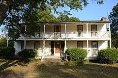
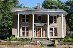
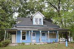
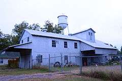
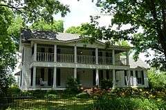
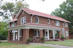
William Thomas Abington House |
|
000000001992-07-11-0000July 11, 1992
(#91001350) |
Center St., southwest of its junction with Highway 367
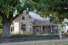
35°04′28″N 91°52′30″W / 35.074444°N 91.875°W / 35.074444; -91.875 (William Thomas Abington House) |
Beebe |
|
| 2 |
Ackins House |
Upload image |
000000001992-07-11-0000July 11, 1992
(#91001322) |
Junction of Highways 31 and 305
35°11′31″N 91°58′01″W / 35.191944°N 91.966944°W / 35.191944; -91.966944 (Ackins House) |
Floyd |
No longer standing.
|
| 3 |
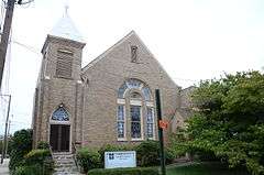
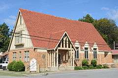
American Legion Hall |
|
000000001991-09-13-0000September 13, 1991
(#91001186) |
Junction of Race and Spruce Sts.
35°15′04″N 91°44′17″W / 35.251111°N 91.738056°W / 35.251111; -91.738056 (American Legion Hall) |
Searcy |
|
| 4 |
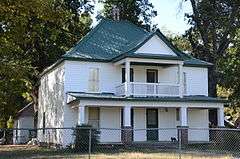
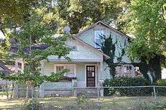
Col. Ralph Andrews House |
|
000000001991-09-05-0000September 5, 1991
(#91001253) |
517 W. Center St.
35°04′05″N 91°53′09″W / 35.068056°N 91.885833°W / 35.068056; -91.885833 (Col. Ralph Andrews House) |
Beebe |
|
| 5 |
Arnold Farmstead |
Upload image |
000000001991-09-13-0000September 13, 1991
(#91001187) |
Off Maple St., south of Deener Creek
35°15′20″N 91°44′32″W / 35.255556°N 91.742222°W / 35.255556; -91.742222 (Arnold Farmstead) |
Searcy |
Demolished.
|
| 6 |
Baldock House |
|
000000001991-09-05-0000September 5, 1991
(#91001239) |
Junction of S. Elm St. and W. Woodruff Ave.
35°14′45″N 91°44′25″W / 35.245833°N 91.740278°W / 35.245833; -91.740278 (Baldock House) |
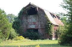
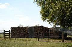
Searcy |
|
| 7 |
Bank of Searcy |
|
000000001991-09-05-0000September 5, 1991
(#91001228) |
301 N. Spruce St.
35°15′01″N 91°44′19″W / 35.250278°N 91.738611°W / 35.250278; -91.738611 (Bank of Searcy) |
Searcy |
|
| 8 |
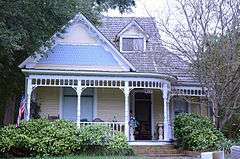
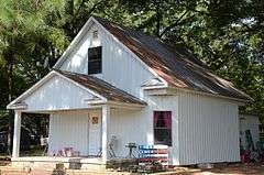
Beebe Jail |
|
000000001991-09-13-0000September 13, 1991
(#91001251) |
East of the junction of N. Main and Illinois Sts.
35°04′17″N 91°52′48″W / 35.071272°N 91.879882°W / 35.071272; -91.879882 (Beebe Jail) |
Beebe |
|
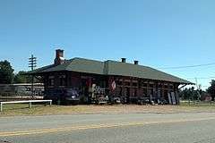
| 9 |
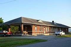
Beebe Railroad Station |
|
000000001979-12-11-0000December 11, 1979
(#79000465) |
Center St.
35°04′11″N 91°52′49″W / 35.069722°N 91.880278°W / 35.069722; -91.880278 (Beebe Railroad Station) |
Beebe |
|
| 10 |
Beebe Theater |
Upload image |
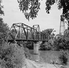
000000001991-09-05-0000September 5, 1991
(#91001265) |
Center St.
35°04′15″N 91°52′46″W / 35.070833°N 91.879444°W / 35.070833; -91.879444 (Beebe Theater) |
Beebe |
Demolished.
|
| 11 |
Bell House |
|
000000001991-09-05-0000September 5, 1991
(#91001201) |
302 W. Woodruff Ave.
35°14′47″N 91°44′24″W / 35.246389°N 91.74°W / 35.246389; -91.74 (Bell House) |
Searcy |
|
| 12 |
Berry House |
|
000000001991-09-05-0000September 5, 1991
(#91001262) |
208 Hickory
35°04′22″N 91°53′14″W / 35.072778°N 91.887222°W / 35.072778; -91.887222 (Berry House) |
Beebe |
|
| 13 |
Big Four School |
|
000000001992-07-10-0000July 10, 1992
(#91001192) |
County Road 383 south of its junction with Highway 258
35°20′44″N 91°38′34″W / 35.345556°N 91.642778°W / 35.345556; -91.642778 (Big Four School) |
Providence |
Demolished.
|
| 14 |
Benjamin Clayton Black House |
|
000000001974-11-20-0000November 20, 1974
(#74000505) |
300 E. Race St.
35°15′36″N 91°44′01″W / 35.26°N 91.733611°W / 35.26; -91.733611 (Benjamin Clayton Black House) |
Searcy |
|
| 15 |
Bloom House |
|
000000001991-09-05-0000September 5, 1991
(#91001176) |
Junction of N. Maple and Academy Sts.
35°15′10″N 91°44′41″W / 35.252778°N 91.744722°W / 35.252778; -91.744722 (Bloom House) |
Searcy |
|
| 16 |
Blunt House Livestock Barn |
Upload image |
000000001992-07-10-0000July 10, 1992
(#91001363) |
County Road 357, east of its junction with Highway 157
35°31′00″N 91°38′13″W / 35.516667°N 91.636944°W / 35.516667; -91.636944 (Blunt House Livestock Barn) |
Midway |
|
| 17 |
James William Boggs House |
|
000000001991-09-05-0000September 5, 1991
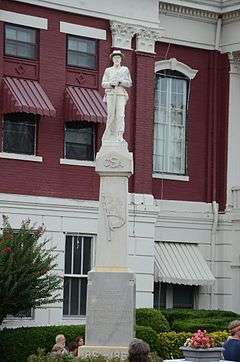
(#91001298) |
Austin St. between South and Torrence Sts.
35°25′29″N 91°50′11″W / 35.424722°N 91.836389°W / 35.424722; -91.836389 (James William Boggs House) |
Pangburn |
|
| 18 |
Luke Bone Grocery-Boarding House |
|
000000001991-09-13-0000September 13, 1991
(#91001275) |
Junction of Main and Market Sts.
35°18′35″N 91°34′00″W / 35.309722°N 91.566667°W / 35.309722; -91.566667 (Luke Bone Grocery-Boarding House) |
Bald Knob |
|
| 19 |
Green Booth House |
|
000000001991-09-05-0000September 5, 1991
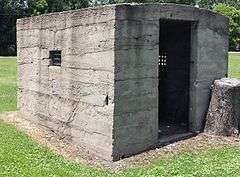
(#91001202) |
Junction of S. Pecan St. and W. Center Ave.
35°14′56″N 91°44′39″W / 35.248889°N 91.744167°W / 35.248889; -91.744167 (Green Booth House) |
Searcy |
|
| 20 |
Booth-Weir House |
|
000000001991-09-05-0000September 5, 1991
(#91001345) |
W. 1st St.
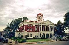
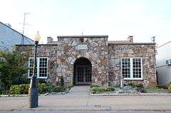
35°07′11″N 91°48′54″W / 35.119722°N 91.815°W / 35.119722; -91.815 (Booth-Weir House) |
McRae |
|
| 21 |
Bradford City Hall-Byers Masonic Lodge |
|
000000001999-10-21-0000October 21, 1999
(#99001260) |
302 W. Walnut St.
35°25′27″N 91°27′19″W / 35.424167°N 91.455278°W / 35.424167; -91.455278 (Bradford City Hall-Byers Masonic Lodge) |
Bradford |
|
| 22 |
Brooks House |
|
000000001992-07-10-0000July 10, 1992
(#91001217) |
704 E. Market St.
35°14′59″N 91°43′48″W / 35.249722°N 91.73°W / 35.249722; -91.73 (Brooks House) |
Searcy |
|
| 23 |
Brown House |
|
000000001991-09-13-0000September 13, 1991
(#91001268) |
Elm St.
35°18′39″N 91°34′07″W / 35.310833°N 91.568611°W / 35.310833; -91.568611 (Brown House) |
Bald Knob |
|
| 24 |
Joe Brown House and Farmstead |
Upload image |
000000001991-09-13-0000September 13, 1991
(#91001338) |
County Road 529 northwest of Little Red
35°28′34″N 91°43′20″W / 35.476111°N 91.722222°W / 35.476111; -91.722222 (Joe Brown House and Farmstead) |
Little Red |
|
| 25 |
Burnett House |
Upload image |
000000001992-07-11-0000July 11, 1992
(#91001337) |
County Road 766 northwest of Searcy
35°15′55″N 91°47′04″W / 35.265278°N 91.784444°W / 35.265278; -91.784444 (Burnett House) |
Searcy |
Demolished.
|
| 26 |
Caldwell House |
|
000000001991-09-05-0000September 5, 1991
(#91001347) |
Junction of E. 2nd and Smith Sts.
35°06′43″N 91°49′19″W / 35.111944°N 91.821944°W / 35.111944; -91.821944 (Caldwell House) |
McRae |
|
| 27 |
Campbell-Chrisp House |
|
000000001991-09-05-0000September 5, 1991
(#91001280) |
102 Elm St.
35°18′38″N 91°34′09″W / 35.310556°N 91.569167°W / 35.310556; -91.569167 (Campbell-Chrisp House) |
Bald Knob |
|
| 28 |
Cary House |
|
000000001992-07-10-0000July 10, 1992
(#91001293) |
Junction of Searcy and Short Sts.
35°25′41″N 91°50′14″W / 35.428056°N 91.837222°W / 35.428056; -91.837222 (Cary House) |
Pangburn |
|
| 29 |
Chandler House |
Upload image |
000000001992-07-10-0000July 10, 1992
(#91001310) |
Junction of County Roads 327 and 379
35°22′41″N 91°37′19″W / 35.378056°N 91.621944°W / 35.378056; -91.621944 (Chandler House) |
Stevens Creek |
|
| 30 |
Childers Farmstead |
|
000000001992-07-11-0000July 11, 1992
(#91001349) |
East of Highway 367 and south of McRae
35°05′38″N 91°49′39″W / 35.093889°N 91.8275°W / 35.093889; -91.8275 (Childers Farmstead) |
McRae |
|
| 31 |
Churchill-Hilger House |
|
000000001991-09-05-0000September 5, 1991
(#91001301) |
Junction of Main and Searcy Sts.
35°25′35″N 91°50′10″W / 35.426389°N 91.836111°W / 35.426389; -91.836111 (Churchill-Hilger House) |
Pangburn |
|
| 32 |
Pattie Cobb Hall |
|
000000001991-09-05-0000September 5, 1991
(#91001209) |
900 E. Center at Harding University
35°14′50″N 91°43′40″W / 35.247222°N 91.727778°W / 35.247222; -91.727778 (Pattie Cobb Hall) |
Searcy |
|
| 33 |
Collison House |
|
000000002008-05-29-0000May 29, 2008
(#08000489) |
206 N. Main St.
35°18′43″N 91°34′03″W / 35.311944°N 91.5675°W / 35.311944; -91.5675 (Collison House) |
Bald Knob |
|
| 34 |
Sam Cooley Barn |
Upload image |
000000001992-07-11-0000July 11, 1992
(#91001282) |
County Road 96 southeast of Bald Knob
35°17′41″N 91°32′53″W / 35.294722°N 91.548056°W / 35.294722; -91.548056 (Sam Cooley Barn) |
Bald Knob |
|
| 35 |
Coward House |
Upload image |
000000001992-07-10-0000July 10, 1992
(#91001229) |
1105 N. Maple St.
35°15′34″N 91°44′42″W / 35.259444°N 91.745°W / 35.259444; -91.745 (Coward House) |
Searcy |
Demolished.
|
| 36 |
Cremane House |
|
000000001992-07-10-0000July 10, 1992
(#91001320) |
County Road 95 west of Bradford Lake
35°25′01″N 91°26′19″W / 35.416944°N 91.438611°W / 35.416944; -91.438611 (Cremane House) |
Bradford |
|
| 37 |
Col. John Critz Farm, Springhouse |
Upload image |
000000001992-07-10-0000July 10, 1992
(#91001333) |
County Road 818 west of its junction with County Road 41
35°17′14″N 91°52′10″W / 35.287222°N 91.869444°W / 35.287222; -91.869444 (Col. John Critz Farm, Springhouse) |
Center Hill |
Demolished.
|
| 38 |
Cross House |
Upload image |
000000001992-07-10-0000July 10, 1992
(#91001259) |
410 S. Main St.
35°03′58″N 91°52′31″W / 35.066111°N 91.875278°W / 35.066111; -91.875278 (Cross House) |
Beebe |
No longer standing.
|
| 39 |
Cumberland Presbyterian Church |
|
000000001992-07-10-0000July 10, 1992
(#91001225) |
Junction of Race and Spring Sts.
35°15′03″N 91°44′14″W / 35.250833°N 91.737222°W / 35.250833; -91.737222 (Cumberland Presbyterian Church) |
Searcy |
|
| 40 |
Jesse N. Cypert Law Office |
|
000000001992-07-12-0000July 12, 1992
(#91001179) |
104 E. Race St.
35°15′04″N 91°44′13″W / 35.251111°N 91.736944°W / 35.251111; -91.736944 (Jesse N. Cypert Law Office) |
Searcy |
|
| 41 |
Darden-Gifford House |
|
000000001976-01-01-0000January 1, 1976
(#76000474) |
North of Rosebud off Highway 5
35°20′15″N 92°04′44″W / 35.3375°N 92.078889°W / 35.3375; -92.078889 (Darden-Gifford House) |
Rosebud |
|
| 42 |
Deener House |
|
000000001982-12-22-0000December 22, 1982
(#82000957) |
310 E. Center Ave.
35°14′54″N 91°43′57″W / 35.248333°N 91.7325°W / 35.248333; -91.7325 (Deener House) |
Searcy |
|
| 43 |
Doniphan Lumber Mill Historic District |
Upload image |
000000001991-09-13-0000September 13, 1991
(#91001196) |
Around Doniphan Lake off Highway 367
35°15′02″N 91°40′31″W / 35.250556°N 91.675278°W / 35.250556; -91.675278 (Doniphan Lumber Mill Historic District) |
Doniphan |
|
| 44 |
David Doyle House No. 2 |
Upload image |
000000001991-09-05-0000September 5, 1991
(#91001302) |
Junction of Highway 5 and County Road 953
35°07′27″N 92°05′40″W / 35.124167°N 92.094444°W / 35.124167; -92.094444 (David Doyle House No. 2) |
El Paso |
Demolished 11/2003.
|
| 45 |
James W. Edie House |
|
000000001991-09-05-0000September 5, 1991
(#91001189) |
Junction of Jackson and Washington Sts.
35°16′07″N 91°38′18″W / 35.268611°N 91.638333°W / 35.268611; -91.638333 (James W. Edie House) |
Judsonia |
|
| 46 |
El Paso Bank |
|
000000001991-09-05-0000September 5, 1991
(#91001303) |
County Road 3 east of its junction with Highway 5
35°07′34″N 92°05′45″W / 35.126111°N 92.095833°W / 35.126111; -92.095833 (El Paso Bank) |
El Paso |
|
| 47 |
Elm Street House |
|
000000001991-09-13-0000September 13, 1991
(#91001269) |
Elm St.
35°18′37″N 91°34′07″W / 35.310278°N 91.568611°W / 35.310278; -91.568611 (Elm Street House) |
Bald Knob |
|
| 48 |
Joe Emmer House |
Upload image |
000000001992-07-12-0000July 12, 1992
(#91001327) |
County Road 47
35°21′36″N 91°45′29″W / 35.36°N 91.758056°W / 35.36; -91.758056 (Joe Emmer House) |
Holly Springs |
Demolished.
|
| 49 |
First United Methodist Church |
|
000000001992-07-12-0000July 12, 1992
(#91001206) |
Junction of Main and Market Sts.
35°15′00″N 91°44′09″W / 35.25°N 91.735833°W / 35.25; -91.735833 (First United Methodist Church) |
Searcy |
|
| 50 |
Floyd Cotton Gin |
|
000000001992-07-12-0000July 12, 1992
(#91001324) |
Junction of Highways 31 and 305
35°11′29″N 91°58′04″W / 35.191389°N 91.967778°W / 35.191389; -91.967778 (Floyd Cotton Gin) |
Floyd |
|
| 51 |
Fox Motel House |
Upload image |
000000001992-07-12-0000July 12, 1992
(#91001267) |
Highway 367
35°18′51″N 91°33′55″W / 35.314167°N 91.565278°W / 35.314167; -91.565278 (Fox Motel House) |
Bald Knob |
No longer standing.
|
| 52 |
Fredonia Cemetery Historic Section |
|
000000002007-01-29-0000January 29, 2007
(#06001312) |
Roughly 0.5 miles (0.80 km) down Fredonia Rd., past its junction with Honeysuckle Rd.
35°23′12″N 91°37′34″W / 35.386667°N 91.626111°W / 35.386667; -91.626111 (Fredonia Cemetery Historic Section) |
Stevens Creek |
|
| 53 |
Wood Freeman House No. 1 |
|
000000001991-09-05-0000September 5, 1991
(#91001185) |
702 Arch St.
35°15′01″N 91°44′40″W / 35.250278°N 91.744444°W / 35.250278; -91.744444 (Wood Freeman House No. 1) |
Searcy |
|
| 54 |
Wood Freeman House No. 2 |
Upload image |
000000001991-09-05-0000September 5, 1991
(#91001181) |
703 W. Race St.
35°15′02″N 91°44′40″W / 35.250556°N 91.744444°W / 35.250556; -91.744444 (Wood Freeman House No. 2) |
Searcy |
No longer standing.
|
| 55 |
Dr. Frizell House |
|
000000001992-07-12-0000July 12, 1992
(#91001318) |
Junction of U.S. Highway 67 and Elm St.
35°25′20″N 91°27′23″W / 35.422222°N 91.456389°W / 35.422222; -91.456389 (Dr. Frizell House) |
Bradford |
|
| 56 |
Lizzie Garrard House |
|
000000001991-09-05-0000September 5, 1991
(#91001263) |
N. Cypress St.
35°04′17″N 91°52′59″W / 35.071389°N 91.883056°W / 35.071389; -91.883056 (Lizzie Garrard House) |
Beebe |
|
| 57 |
Milt Gooden House |
Upload image |
000000001992-07-13-0000July 13, 1992
(#91001281) |
County Road 83 southeast of Bald Knob
35°15′15″N 91°32′10″W / 35.254167°N 91.536111°W / 35.254167; -91.536111 (Milt Gooden House) |
Bald Knob |
No longer standing.
|
| 58 |
Leonard Gordon Homestead, Hexagonal Grain Crib |
Upload image |
000000001992-07-21-0000July 21, 1992
(#91001311) |
County Road 69
35°22′34″N 91°36′01″W / 35.376111°N 91.600278°W / 35.376111; -91.600278 (Leonard Gordon Homestead, Hexagonal Grain Crib) |
Twentythree |
|
| 59 |
Grand Army of the Republic Memorial |
|
000000001996-05-03-0000May 3, 1996
(#96000502) |
Evergreen Cemetery, approximately 0.25 miles (0.40 km) south of the junction of Highways 367 and 13
35°16′41″N 91°38′25″W / 35.278056°N 91.640278°W / 35.278056; -91.640278 (Grand Army of the Republic Memorial) |
Judsonia |
|
| 60 |
Gravel Hill Baptist Church |
|
000000001992-07-21-0000July 21, 1992
(#91001323) |
Gravel Hill Rd.
35°14′56″N 91°58′40″W / 35.248889°N 91.977778°W / 35.248889; -91.977778 (Gravel Hill Baptist Church) |
Gravel Hill |
Demolished.
|
| 61 |
Gray House |
|
000000001992-07-21-0000July 21, 1992
(#91001334) |
Junction of County Roads 46 and 758
35°18′27″N 91°48′48″W / 35.3075°N 91.813333°W / 35.3075; -91.813333 (Gray House) |
Crosby |
Demolished.
|
| 62 |
Louis Gray Homestead, Barn |
|
000000001992-07-21-0000July 21, 1992
(#91001194) |
Highway 157 east of Plainview
35°18′48″N 91°39′18″W / 35.313333°N 91.655°W / 35.313333; -91.655 (Louis Gray Homestead, Barn) |
Plainview |
Demolished.
|
| 63 |
Rufus Gray House |
|
000000001991-09-05-0000September 5, 1991
(#91001294) |
Junction of Austin and South Sts.
35°25′27″N 91°50′10″W / 35.424167°N 91.836111°W / 35.424167; -91.836111 (Rufus Gray House) |
Pangburn |
|
| 64 |
Gray-Kincaid House |
|
000000001992-07-21-0000July 21, 1992
(#91001335) |
Junction of County Roads 46 and 759
35°19′01″N 91°49′17″W / 35.316944°N 91.821389°W / 35.316944; -91.821389 (Gray-Kincaid House) |
Crosby |
|
| 65 |
Griffithville School |
Upload image |
000000001992-07-13-0000July 13, 1992
(#91001357) |
Highway 11 west of its junction with Highway 385
35°07′14″N 91°38′54″W / 35.120556°N 91.648333°W / 35.120556; -91.648333 (Griffithville School) |
Griffithville |
Building listed on the NRHP has been demolished, but the gym and another building dating to the same period still stand.
|
| 66 |
Thomas Jefferson Hale General Merchandise Store |
|
000000001992-07-21-0000July 21, 1992
(#91001358) |
Junction of County Roads 62 and 433
35°04′46″N 91°44′37″W / 35.079444°N 91.743611°W / 35.079444; -91.743611 (Thomas Jefferson Hale General Merchandise Store) |
Vinity Corner |
|
| 67 |
Fred Hall House |
|
000000001991-09-05-0000September 5, 1991
(#91001222) |
Junction of 2nd and W. Searcy Sts.
35°13′58″N 91°40′07″W / 35.232778°N 91.668611°W / 35.232778; -91.668611 (Fred Hall House) |
Kensett |
|
| 68 |
Mary Alice Hammond House |
|
000000001992-07-21-0000July 21, 1992
(#91001204) |
County Road 839 west of its junction with Highway 367
35°11′41″N 91°44′04″W / 35.194722°N 91.734444°W / 35.194722; -91.734444 (Mary Alice Hammond House) |
Searcy |
|
| 69 |
Roy Harper House |
Upload image |
000000001992-07-21-0000July 21, 1992
(#91001304) |
County Road 16 east of its junction with Highway 5
35°11′26″N 92°02′53″W / 35.190556°N 92.048056°W / 35.190556; -92.048056 (Roy Harper House) |
Romance |
|
| 70 |
Morris Hartsell Farmstead |
Upload image |
000000001991-09-13-0000September 13, 1991
(#91001340) |
Highway 157
35°25′48″N 91°41′09″W / 35.43°N 91.685833°W / 35.43; -91.685833 (Morris Hartsell Farmstead) |
Steprock |
|
| 71 |
Hassell House |
|
000000001991-09-05-0000September 5, 1991
(#91001205) |
Junction of S. Elm St. and W. Woodruff Ave.
35°14′45″N 91°44′27″W / 35.245833°N 91.740833°W / 35.245833; -91.740833 (Hassell House) |
Searcy |
|
| 72 |
Brady Hays Homestead |
Upload image |
000000001991-09-13-0000September 13, 1991
(#91001312) |
U.S. Highway 167 south of Denmark
35°28′12″N 91°35′17″W / 35.47°N 91.588056°W / 35.47; -91.588056 (Brady Hays Homestead) |
Denmark |
Burned 7/15/2007.
|
| 73 |
Alfred W. Henson House |
Upload image |
000000001986-10-23-0000October 23, 1986
(#86002938) |
111 Main St.
35°16′14″N 91°38′27″W / 35.270556°N 91.640833°W / 35.270556; -91.640833 (Alfred W. Henson House) |
Judsonia |
Burned and demolished.
|
| 74 |
Marshall Hickmon Homestead |
|
000000001992-07-21-0000July 21, 1992
(#91001317) |
Highway 87
35°25′28″N 91°27′55″W / 35.424444°N 91.465278°W / 35.424444; -91.465278 (Marshall Hickmon Homestead) |
Bradford |
|
| 75 |
U.L. Hickmon Hardware Store |
|
000000001991-09-05-0000September 5, 1991
(#91001316) |
Junction of Main and 2nd Sts.
35°25′25″N 91°27′20″W / 35.423611°N 91.455556°W / 35.423611; -91.455556 (U.L. Hickmon Hardware Store) |
Bradford |
|
| 76 |
Ida Hicks House |
Upload image |
000000001991-09-05-0000September 5, 1991
(#91001180) |
410 W. Arch St.
35°15′01″N 91°44′29″W / 35.250278°N 91.741389°W / 35.250278; -91.741389 (Ida Hicks House) |
Searcy |
Demolished prior to 2004.
|
| 77 |
Hicks-Dugan-Deener House |
|
000000001985-04-18-0000April 18, 1985
(#85000835) |
306 E. Center St.
35°14′54″N 91°43′51″W / 35.248333°N 91.730833°W / 35.248333; -91.730833 (Hicks-Dugan-Deener House) |
Searcy |
|
| 78 |
Louis N. Hilger Homestead, Livestock Barn |
|
000000001992-07-21-0000July 21, 1992
(#91001191) |
County Road 374 west of its junction with Highway 157
35°22′10″N 91°41′31″W / 35.369444°N 91.691944°W / 35.369444; -91.691944 (Louis N. Hilger Homestead, Livestock Barn) |
Providence |
|
| 79 |
Hill Farm |
|
000000001992-07-21-0000July 21, 1992
(#91001258) |
North of U.S. Highway 67 southwest of Beebe
35°03′37″N 91°56′42″W / 35.060278°N 91.945°W / 35.060278; -91.945 (Hill Farm) |
Beebe |
|
| 80 |
Hoag House |
Upload image |
000000001992-07-21-0000July 21, 1992
(#91001236) |
Junction of Highways 157 and 367
35°17′07″N 91°37′49″W / 35.285278°N 91.630278°W / 35.285278; -91.630278 (Hoag House) |
Judsonia |
Demolished.
|
| 81 |
Holly Grove School |
Upload image |
000000001992-07-13-0000July 13, 1992
(#91001309) |
County Road 379 north of its junction with County Road 327
35°22′41″N 91°37′20″W / 35.378056°N 91.622222°W / 35.378056; -91.622222 (Holly Grove School) |
Stevens Creek |
Burned in early 2014.
|
| 82 |
Hoofman Farmstead Barn |
|
000000001992-07-22-0000July 22, 1992
(#91001188) |
Between Plainview and the Little Red River
35°18′30″N 91°41′52″W / 35.308333°N 91.697778°W / 35.308333; -91.697778 (Hoofman Farmstead Barn) |
Searcy |
|
| 83 |
Arthur W. Hoofman House |
|
000000001992-07-22-0000July 22, 1992
(#91001184) |
Junction of E. Race and N. Cross Sts.
35°15′01″N 91°43′24″W / 35.250278°N 91.723333°W / 35.250278; -91.723333 (Arthur W. Hoofman House) |
Searcy |
|
| 84 |
Tobe Hoofman Farmstead |
|
000000001992-07-22-0000July 22, 1992
(#91001238) |
Highway 13 north of its junction with Highway 157
35°19′18″N 91°39′43″W / 35.321667°N 91.661944°W / 35.321667; -91.661944 (Tobe Hoofman Farmstead) |
Providence |
|
| 85 |
Hopewell District No. 45 School |
Upload image |
000000001992-07-13-0000July 13, 1992
(#91001283) |
Highway 258 west of Lake Bald Knob
35°20′12″N 91°36′05″W / 35.336667°N 91.601389°W / 35.336667; -91.601389 (Hopewell District No. 45 School) |
Hopewell |
Demolished.
|
| 86 |
Hunt House |
|
000000001991-09-13-0000September 13, 1991
(#91001207) |
707 W. Center St.
35°14′54″N 91°44′41″W / 35.248333°N 91.744722°W / 35.248333; -91.744722 (Hunt House) |
Searcy |
|
| 87 |
Thomas Hunt House |
Upload image |
000000001992-07-22-0000July 22, 1992
(#91001193) |
Highway 157 north of Plainview
35°20′01″N 91°40′35″W / 35.333611°N 91.676389°W / 35.333611; -91.676389 (Thomas Hunt House) |
Plainview |
Burned to the ground 9-24-2015.
|
| 88 |
L.D. Hutchinson House |
|
000000001992-07-22-0000July 22, 1992
(#91001325) |
Highway 31 north of its junction with Highway 305
35°11′47″N 91°58′02″W / 35.196389°N 91.967222°W / 35.196389; -91.967222 (L.D. Hutchinson House) |
Floyd |
|
| 89 |
Dr. James House |
Upload image |
000000001991-09-13-0000September 13, 1991
(#91001241) |
Junction of W. Center and S. Gum Sts.
35°14′55″N 91°44′22″W / 35.248611°N 91.739444°W / 35.248611; -91.739444 (Dr. James House) |
Searcy |
; probably demolished
|
| 90 |
Jameson-Richards Cafe |
|
000000001991-09-05-0000September 5, 1991
(#91001266) |
Highway 367 east of its junction with Vine St.
35°18′35″N 91°34′07″W / 35.309722°N 91.568611°W / 35.309722; -91.568611 (Jameson-Richards Cafe) |
Bald Knob |
|
| 91 |
Jameson-Richards Gas Station |
|
000000001991-09-05-0000September 5, 1991
(#91001279) |
Junction of Highway 367 and Vine St.
35°18′34″N 91°34′08″W / 35.309444°N 91.568889°W / 35.309444; -91.568889 (Jameson-Richards Gas Station) |
Bald Knob |
|
| 92 |
Joiner House |
|
000000001992-07-22-0000July 22, 1992
(#91001214) |
708 Market St.
35°14′59″N 91°43′45″W / 35.249722°N 91.729167°W / 35.249722; -91.729167 (Joiner House) |
Searcy |
|
| 93 |
Mark P. Jones House |
|
000000001991-09-05-0000September 5, 1991
(#91001197) |
Junction of Center and Fir Sts.
35°14′55″N 91°44′33″W / 35.248611°N 91.7425°W / 35.248611; -91.7425 (Mark P. Jones House) |
Searcy |
|
| 94 |
Judsonia Bridge |
|
000000001990-04-09-0000April 9, 1990
(#90000535) |
County Road 66 over the Little Red River
35°16′03″N 91°38′23″W / 35.2675°N 91.639722°W / 35.2675; -91.639722 (Judsonia Bridge) |
Judsonia |
|
| 95 |
Judsonia Community Building Historic District |
|
000000001991-09-05-0000September 5, 1991
(#91001234) |
Junction of Judson Ave. and 6th St.
35°16′22″N 91°38′20″W / 35.272778°N 91.638889°W / 35.272778; -91.638889 (Judsonia Community Building Historic District) |
Judsonia |
|
| 96 |
C.D. Kelly House |
|
000000001991-09-05-0000September 5, 1991
(#91001190) |
Junction of Main and Adams Sts.
35°16′12″N 91°38′27″W / 35.27°N 91.640833°W / 35.27; -91.640833 (C.D. Kelly House) |
Judsonia |
|
| 97 |
Kerr-Booth House |
|
000000002006-03-02-0000March 2, 2006
(#06000076) |
611 W. Center Ave.
35°15′01″N 91°44′34″W / 35.250278°N 91.742778°W / 35.250278; -91.742778 (Kerr-Booth House) |
Searcy |
|
| 98 |
S.A. Kimbrough House |
|
000000001991-09-05-0000September 5, 1991
(#91001252) |
302 E. Illinois St.
35°04′21″N 91°52′43″W / 35.0725°N 91.878611°W / 35.0725; -91.878611 (S.A. Kimbrough House) |
Beebe |
|
| 99 |
Henry W. Klotz, Sr., Service Station |
|
000000001991-09-13-0000September 13, 1991
(#91001273) |
W. 1st St.
35°21′51″N 91°30′27″W / 35.364167°N 91.5075°W / 35.364167; -91.5075 (Henry W. Klotz, Sr., Service Station) |
Russell |
|
| 100 |
Henry Klotz, Sr., House |
|
000000001992-07-22-0000July 22, 1992
(#91001285) |
1st St.
35°21′52″N 91°30′26″W / 35.364444°N 91.507222°W / 35.364444; -91.507222 (Henry Klotz, Sr., House) |
Russell |
|
| 101 |
Capt. Larned House |
|
000000001992-07-22-0000July 22, 1992
(#91001235) |
Highway 157 north of U.S. Highway 64
35°18′14″N 91°38′37″W / 35.303889°N 91.643611°W / 35.303889; -91.643611 (Capt. Larned House) |
Judsonia |
|
| 102 |
Lattimer House |
|
000000001991-09-05-0000September 5, 1991
(#91001215) |
Junction of Oak and Market Sts.
35°14′59″N 91°44′03″W / 35.249722°N 91.734167°W / 35.249722; -91.734167 (Lattimer House) |
Searcy |
|
| 103 |
Laws-Jarvis House |
|
000000001992-07-22-0000July 22, 1992
(#91001256) |
409 N. Main St.
35°04′22″N 91°52′55″W / 35.072778°N 91.881944°W / 35.072778; -91.881944 (Laws-Jarvis House) |
Beebe |
|
| 104 |
Harvey Lea House |
Upload image |
000000001992-07-13-0000July 13, 1992
(#91001270) |
County Road 70
35°21′53″N 91°30′40″W / 35.364722°N 91.511111°W / 35.364722; -91.511111 (Harvey Lea House) |
Russell |
Burned down.
|
| 105 |
Leggett House |
Upload image |
000000001992-07-13-0000July 13, 1992
(#91001339) |
Highway 124 east of Little Red
35°26′56″N 91°43′50″W / 35.448889°N 91.730556°W / 35.448889; -91.730556 (Leggett House) |
Little Red |
|
| 106 |
Lemay House |
Upload image |
000000001992-07-20-0000July 20, 1992
(#91001254) |
305 S. Cypress St.
35°03′39″N 91°52′37″W / 35.060833°N 91.876944°W / 35.060833; -91.876944 (Lemay House) |
Beebe |
No longer standing.
|
| 107 |
Letona Hotel |
|
000000001991-09-13-0000September 13, 1991
(#91001329) |
Off Highway 310
35°21′44″N 91°49′45″W / 35.362222°N 91.829167°W / 35.362222; -91.829167 (Letona Hotel) |
Letona |
|
| 108 |
Lightle House |
|
000000001982-12-22-0000December 22, 1982
(#82000958) |
605 Race Ave.
35°15′01″N 91°43′50″W / 35.250278°N 91.730556°W / 35.250278; -91.730556 (Lightle House) |
Searcy |
|
| 109 |
Lightle House |
Upload image |
000000001992-07-20-0000July 20, 1992
(#91001224) |
County Road 76
35°15′20″N 91°42′40″W / 35.255556°N 91.711111°W / 35.255556; -91.711111 (Lightle House) |
Searcy |
|
| 110 |
Lightle House |
Upload image |
000000001991-09-05-0000September 5, 1991
(#91001244) |
107 N. Elm St.
35°14′57″N 91°44′27″W / 35.249167°N 91.740833°W / 35.249167; -91.740833 (Lightle House) |
Searcy |
Demolished.
|
| 111 |
Ben Lightle House |
|
000000001991-09-05-0000September 5, 1991
(#91001216) |
Junction of N. Locust and E. Market Sts.
35°14′58″N 91°44′06″W / 35.249444°N 91.735°W / 35.249444; -91.735 (Ben Lightle House) |
Searcy |
|
| 112 |
William H. Lightle House |
|
000000001991-09-05-0000September 5, 1991
(#91001226) |
601 E. Race St.
35°15′02″N 91°43′55″W / 35.250556°N 91.731944°W / 35.250556; -91.731944 (William H. Lightle House) |
Searcy |
|
| 113 |
Jim Little House |
Upload image |
000000001991-09-05-0000September 5, 1991
(#91001315) |
Walnut St. east of its junction with Front St.
35°25′24″N 91°27′11″W / 35.423333°N 91.453056°W / 35.423333; -91.453056 (Jim Little House) |
Bradford |
No longer standing.
|
| 114 |
Livestock and Equipment Barn, Glenn Homestead |
|
000000001992-07-20-0000July 20, 1992
(#91001287) |
Highway 124 northeast of Pangburn
35°25′51″N 91°48′00″W / 35.430833°N 91.8°W / 35.430833; -91.8 (Livestock and Equipment Barn, Glenn Homestead) |
Pangburn |
|
| 115 |
Lone Star School |
Upload image |
000000001992-07-20-0000July 20, 1992
(#91001355) |
East of Big Mingo Creek
35°13′20″N 91°30′05″W / 35.222222°N 91.501389°W / 35.222222; -91.501389 (Lone Star School) |
Lone Star |
Demolished.
|
| 116 |
Dr. Lovell House |
|
000000001992-07-20-0000July 20, 1992
(#91001314) |
Walnut St. east of its junction with Main St.
35°25′28″N 91°27′25″W / 35.424444°N 91.456944°W / 35.424444; -91.456944 (Dr. Lovell House) |
Bradford |
|
| 117 |
E.D. Maddox Farm Chicken House |
Upload image |
000000001992-07-20-0000July 20, 1992
(#91001359) |
County Road 36 east of its junction with Highway 5
35°19′57″N 92°04′25″W / 35.3325°N 92.073611°W / 35.3325; -92.073611 (E.D. Maddox Farm Chicken House) |
Rosebud |
; possibly moved or demolished.
|
| 118 |
Walter Marsh House |
|
000000001991-09-05-0000September 5, 1991
(#91001288) |
Junction of Maple and Torrence Sts.
35°25′24″N 91°50′30″W / 35.423333°N 91.841667°W / 35.423333; -91.841667 (Walter Marsh House) |
Pangburn |
|
| 119 |
Wesley Marsh House |
|
000000001992-07-20-0000July 20, 1992
(#91001328) |
Junction of Highways 16 and 305
35°22′19″N 91°48′33″W / 35.371944°N 91.809167°W / 35.371944; -91.809167 (Wesley Marsh House) |
Letona |
|
| 120 |
Martindale Corn Crib |
|
000000001992-07-20-0000July 20, 1992
(#91001330) |
Highway 310
35°21′43″N 91°50′28″W / 35.361944°N 91.841111°W / 35.361944; -91.841111 (Martindale Corn Crib) |
Letona |
|
| 121 |
Mason House |
Upload image |
000000001992-07-20-0000July 20, 1992
(#91001319) |
W. Main St. west of its junction with Walnut St.
35°25′30″N 91°27′37″W / 35.425°N 91.460278°W / 35.425; -91.460278 (Mason House) |
Bradford |
No longer standing.
|
| 122 |
Mayfair Hotel |
|
000000001991-09-05-0000September 5, 1991
(#91001242) |
Junction of Spring and Center Sts.
35°14′56″N 91°44′16″W / 35.248889°N 91.737778°W / 35.248889; -91.737778 (Mayfair Hotel) |
Searcy |
|
| 123 |
McAdams House |
|
000000001991-09-05-0000September 5, 1991
(#91001289) |
Junction of Maple and South Sts.
35°25′21″N 91°50′25″W / 35.4225°N 91.840278°W / 35.4225; -91.840278 (McAdams House) |
Pangburn |
|
| 124 |
Dr. McAdams House |
Upload image |
000000001991-09-13-0000September 13, 1991
(#91001300) |
Junction of Maple and Searcy Sts.
35°25′29″N 91°50′08″W / 35.424722°N 91.835556°W / 35.424722; -91.835556 (Dr. McAdams House) |
Pangburn |
Demolished prior to 2010.
|
| 125 |
Emmett McDonald House |
|
000000001992-07-20-0000July 20, 1992
(#91001368) |
County Road 443 southeast of McRae
35°05′40″N 91°48′27″W / 35.094444°N 91.8075°W / 35.094444; -91.8075 (Emmett McDonald House) |
McRae |
|
| 126 |
McRae Jail |
|
000000001992-07-20-0000July 20, 1992
(#91001344) |
E. 1st St.
35°06′48″N 91°49′16″W / 35.113333°N 91.821111°W / 35.113333; -91.821111 (McRae Jail) |
McRae |
|
| 127 |
Methodist Episcopal Church, South |
|
000000001992-07-20-0000July 20, 1992
(#91001278) |
Junction of Main and Center Sts.
35°18′40″N 91°34′04″W / 35.311111°N 91.567778°W / 35.311111; -91.567778 (Methodist Episcopal Church, South) |
Bald Knob |
|
| 128 |
Emmett Miller House |
Upload image |
000000001992-07-20-0000July 20, 1992
(#91001237) |
Highway 13 east of Plainview
35°18′38″N 91°39′38″W / 35.310556°N 91.660556°W / 35.310556; -91.660556 (Emmett Miller House) |
Plainview |
Demolished.
|
| 129 |
Mills House |
|
000000001991-09-05-0000September 5, 1991
(#91001220) |
200 W. Searcy St.
35°13′59″N 91°40′09″W / 35.233056°N 91.669167°W / 35.233056; -91.669167 (Mills House) |
Kensett |
|
| 130 |
Missouri Pacific Depot |
|
000000001992-07-20-0000July 20, 1992
(#91001276) |
Junction of Market and Ramey Sts.
35°18′28″N 91°34′09″W / 35.307778°N 91.569167°W / 35.307778; -91.569167 (Missouri Pacific Depot) |
Bald Knob |
|
| 131 |
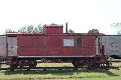
Missouri Pacific Railway Caboose No. 928 |
|
000000002011-05-16-0000May 16, 2011
(#11000303) |
Next to UPRR on Market St., southwest of Vine St.
35°18′28″N 91°34′09″W / 35.307778°N 91.569167°W / 35.307778; -91.569167 (Missouri Pacific Railway Caboose No. 928) |
Bald Knob |
|
| 132 |
Moody House |
|
000000001992-07-20-0000July 20, 1992
(#91001277) |
104 Market St.
35°18′24″N 91°34′16″W / 35.306667°N 91.571111°W / 35.306667; -91.571111 (Moody House) |
Bald Knob |
|
| 133 |
Moore House |
|
000000001991-09-13-0000September 13, 1991
(#91001210) |
405 Center St.
35°14′54″N 91°44′27″W / 35.248333°N 91.740833°W / 35.248333; -91.740833 (Moore House) |
Searcy |
|
| 134 |
Morris House |
|
000000001978-12-04-0000December 4, 1978
(#78000641) |
Route 1
35°29′03″N 91°37′31″W / 35.484167°N 91.625278°W / 35.484167; -91.625278 (Morris House) |
Bradford |
|
| 135 |
Morris Institute Dairy Barn |
Upload image |
000000001992-07-20-0000July 20, 1992
(#91001332) |
County Road 41 south of its junction with County Road 818
35°16′31″N 91°52′01″W / 35.275278°N 91.866944°W / 35.275278; -91.866944 (Morris Institute Dairy Barn) |
Crosby |
Demolished.
|
| 136 |
J.A. Neaville House |
|
000000001992-07-22-0000July 22, 1992
(#91001356) |
Highway 385 north of its junction with Highway 11
35°07′26″N 91°38′40″W / 35.123889°N 91.644444°W / 35.123889; -91.644444 (J.A. Neaville House) |
Griffithville |
|
| 137 |
New Mt. Pisgah School |
|
000000001992-07-20-0000July 20, 1992
(#91001331) |
Between Mt. Pisgah and Little Creek
35°19′45″N 91°49′48″W / 35.329167°N 91.83°W / 35.329167; -91.83 (New Mt. Pisgah School) |
New Mt. Pisgah |
|
| 138 |
Nimmo Clubhouse |
|
000000001992-07-22-0000July 22, 1992
(#91001360) |
County Road 65 at the Little Red River
35°11′03″N 91°28′34″W / 35.184167°N 91.476111°W / 35.184167; -91.476111 (Nimmo Clubhouse) |
Nimmo |
|
| 139 |
Howard O'Neal Barn |
Upload image |
000000001992-07-20-0000July 20, 1992
(#91001286) |
County Road 73 south of Russell
35°21′19″N 91°30′21″W / 35.355278°N 91.505833°W / 35.355278; -91.505833 (Howard O'Neal Barn) |
Russell |
Demolished.
|
| 140 |
Austin Pangburn House |
|
000000001991-09-05-0000September 5, 1991
(#91001290) |
Junction of Main and Austin Sts.
35°25′34″N 91°50′16″W / 35.426111°N 91.837778°W / 35.426111; -91.837778 (Austin Pangburn House) |
Pangburn |
|
| 141 |
Paschall House |
|
000000001991-09-05-0000September 5, 1991
(#91001203) |
Junction of N. Oak and E. Center Sts.
35°14′56″N 91°44′02″W / 35.248889°N 91.733889°W / 35.248889; -91.733889 (Paschall House) |
Searcy |
|
| 142 |
Patman House |
Upload image |
000000001991-09-05-0000September 5, 1991
(#91001292) |
Junction of Mountain and Jackson Sts.
35°25′17″N 91°50′30″W / 35.421389°N 91.841667°W / 35.421389; -91.841667 (Patman House) |
Pangburn |
Demolished prior to 2010.
|
| 143 |
Pence-Carmichael Farm, Barn and Root Cellar |
|
000000001992-07-20-0000July 20, 1992
(#91001305) |
Off Highway 31 east of Romance
35°14′29″N 92°02′25″W / 35.241389°N 92.040278°W / 35.241389; -92.040278 (Pence-Carmichael Farm, Barn and Root Cellar) |
Romance |
|
| 144 |
Plummer House |
|
000000001992-07-22-0000July 22, 1992
(#91001247) |
314 Alabama St.
35°03′39″N 91°52′37″W / 35.060833°N 91.876944°W / 35.060833; -91.876944 (Plummer House) |
Beebe |
|
| 145 |
Powell Clothing Store |
|
000000001991-09-05-0000September 5, 1991
(#91001249) |
201 N. Main St.
35°04′16″N 91°52′51″W / 35.071111°N 91.880833°W / 35.071111; -91.880833 (Powell Clothing Store) |
Beebe |
|
| 146 |
Prince House |
Upload image |
000000001992-07-22-0000July 22, 1992
(#91001307) |
County Road 68 northwest of Velvet Ridge
35°26′19″N 91°35′50″W / 35.438611°N 91.597222°W / 35.438611; -91.597222 (Prince House) |
Velvet Ridge |
|
| 147 |
Edward Ransom Farmstead, Livestock and Equipment Barn |
Upload image |
000000001992-07-22-0000July 22, 1992
(#91001361) |
County Road 359 west of its junction with U.S. Highway 167
35°30′11″N 91°36′46″W / 35.503056°N 91.612778°W / 35.503056; -91.612778 (Edward Ransom Farmstead, Livestock and Equipment Barn) |
Midway |
Demolished.
|
| 148 |
Rascoe House |
Upload image |
000000001992-07-23-0000July 23, 1992
(#91001213) |
702 Main St.
35°14′33″N 91°44′10″W / 35.2425°N 91.736111°W / 35.2425; -91.736111 (Rascoe House) |
Searcy |
No longer standing.
|
| 149 |
Sam Ray House |
|
000000001992-07-23-0000July 23, 1992
(#91001296) |
Highway 305 northeast of its junction with County Road 47
35°24′02″N 91°46′58″W / 35.400556°N 91.782778°W / 35.400556; -91.782778 (Sam Ray House) |
Clay |
|
| 150 |
J.C. Rhew Co. Packing Shed |
Upload image |
000000001992-07-23-0000July 23, 1992
(#91001343) |
County Road 376 northeast of Providence
35°23′57″N 91°38′53″W / 35.399167°N 91.648056°W / 35.399167; -91.648056 (J.C. Rhew Co. Packing Shed) |
Providence |
No longer standing.
|
| 151 |
Rialto Theater |
|
000000001991-09-13-0000September 13, 1991
(#91001231) |
Junction of Race and Spring Sts.
35°15′03″N 91°44′16″W / 35.250833°N 91.737778°W / 35.250833; -91.737778 (Rialto Theater) |
Searcy |
|
| 152 |
Robertson Drugstore |
|
000000001991-09-13-0000September 13, 1991
(#91001245) |
Junction of Spring and Arch Sts.
35°15′00″N 91°44′16″W / 35.25°N 91.737778°W / 35.25; -91.737778 (Robertson Drugstore) |
Searcy |
|
| 153 |
Robertson House |
|
000000001991-09-05-0000September 5, 1991
(#91001221) |
Junction of 2nd and Dandridge Sts.
35°13′55″N 91°40′13″W / 35.231944°N 91.670278°W / 35.231944; -91.670278 (Robertson House) |
Kensett |
|
| 154 |
Rock Building |
|
000000001992-07-23-0000July 23, 1992
(#91001195) |
County Road 370 south of its junction with Highway 157
35°18′00″N 91°40′09″W / 35.3°N 91.669167°W / 35.3; -91.669167 (Rock Building) |
Plainview |
|
| 155 |
Porter Rodgers, Sr., House |
Upload image |
000000001991-09-05-0000September 5, 1991
(#91001230) |
Junction of N. Oak and E. Race Sts.
35°14′54″N 91°44′41″W / 35.248333°N 91.744722°W / 35.248333; -91.744722 (Porter Rodgers, Sr., House) |
Searcy |
Demolished.
|
| 156 |
Bob Rogers House |
Upload image |
000000001991-09-13-0000September 13, 1991
(#91001219) |
Junction of S. Spring St. and W. Woodruff Ave.
35°14′45″N 91°44′14″W / 35.245833°N 91.737222°W / 35.245833; -91.737222 (Bob Rogers House) |
Searcy |
Demolished.
|
| 157 |
Russell Jail |
|
000000001992-07-23-0000July 23, 1992
(#91001271) |
Off Elm St.
35°21′46″N 91°30′33″W / 35.362778°N 91.509167°W / 35.362778; -91.509167 (Russell Jail) |
Russell |
|
| 158 |
St. Richard's Catholic Church |
|
000000001992-07-20-0000July 20, 1992
(#91001274) |
Junction of Hickory and Cleveland Sts.
35°18′42″N 91°34′14″W / 35.311667°N 91.570556°W / 35.311667; -91.570556 (St. Richard's Catholic Church) |
Bald Knob |
|
| 159 |
Scott-Davis House |
Upload image |
000000001992-07-20-0000July 20, 1992
(#91001306) |
County Road 15 southwest of Romance
35°13′41″N 92°03′29″W / 35.228056°N 92.058056°W / 35.228056; -92.058056 (Scott-Davis House) |
Romance |
|
| 160 |
Searcy Confederate Monument |
|
000000001996-04-26-0000April 26, 1996
(#96000458) |
Courthouse lawn near the junction of W. Arch Ave. and Spring St.
35°15′03″N 91°44′18″W / 35.250833°N 91.738333°W / 35.250833; -91.738333 (Searcy Confederate Monument) |
Searcy |
|
| 161 |
Searcy Post Office |
|
000000001992-07-20-0000July 20, 1992
(#91001200) |
Southwestern corner of the junction of Gum and Arch Sts.
35°14′59″N 91°44′24″W / 35.249722°N 91.74°W / 35.249722; -91.74 (Searcy Post Office) |
Searcy |
; now the municipal courthouse
|
| 162 |
Dean L.C. Sears House |
Upload image |
000000001992-07-20-0000July 20, 1992
(#91001208) |
805 E. Center St.
35°14′54″N 91°43′41″W / 35.248333°N 91.728056°W / 35.248333; -91.728056 (Dean L.C. Sears House) |
Searcy |
Demolished prior to 2004.
|
| 163 |
Sellers House |
|
000000001991-09-05-0000September 5, 1991
(#91001261) |
702 W. Center St.
35°04′06″N 91°53′16″W / 35.068333°N 91.887778°W / 35.068333; -91.887778 (Sellers House) |
Beebe |
|
| 164 |
Shue House |
|
000000001991-09-05-0000September 5, 1991
(#91001257) |
108 Holly St.
35°04′08″N 91°53′18″W / 35.068889°N 91.888333°W / 35.068889; -91.888333 (Shue House) |
Beebe |
|
| 165 |
John Shutter House |
|
000000001991-09-05-0000September 5, 1991
(#91001299) |
Junction of Austin and Main Sts.
35°25′32″N 91°50′15″W / 35.425556°N 91.8375°W / 35.425556; -91.8375 (John Shutter House) |
Pangburn |
|
| 166 |
Stanley Simpson Farmstead Picking Shed |
Upload image |
000000001991-09-13-0000September 13, 1991
(#91001342) |
County Road 390 west of its junction with Highway 157
35°22′44″N 91°41′25″W / 35.378889°N 91.690278°W / 35.378889; -91.690278 (Stanley Simpson Farmstead Picking Shed) |
Providence |
|
| 167 |
Smith House |
|
000000001991-09-05-0000September 5, 1991
(#91001218) |
607 W. Arch Ave.
35°15′00″N 91°44′36″W / 35.25°N 91.743333°W / 35.25; -91.743333 (Smith House) |
Searcy |
|
| 168 |
A.J. Smith House |
Upload image |
000000001991-09-05-0000September 5, 1991
(#91001223) |
Highway 385
35°07′35″N 91°38′41″W / 35.126389°N 91.644722°W / 35.126389; -91.644722 (A.J. Smith House) |
Griffithville |
No longer standing.
|
| 169 |
Smith-Moore House |
Upload image |
000000001992-07-20-0000July 20, 1992
(#91001246) |
901 N. Main St.
35°04′41″N 91°52′55″W / 35.078056°N 91.881944°W / 35.078056; -91.881944 (Smith-Moore House) |
Beebe |
|
| 170 |
Smyrna Methodist Church |
|
000000001992-07-20-0000July 20, 1992
(#91001336) |
Highway 36 east of Center Hill
35°15′08″N 91°51′11″W / 35.252222°N 91.853056°W / 35.252222; -91.853056 (Smyrna Methodist Church) |
Center Hill |
|
| 171 |
Dr. Emmett Snipes House |
Upload image |
000000001991-09-05-0000September 5, 1991
(#91001243) |
Junction of E. Market and N. Locust Sts.
35°14′59″N 91°44′05″W / 35.249722°N 91.734722°W / 35.249722; -91.734722 (Dr. Emmett Snipes House) |
Searcy |
No longer standing.
|
| 172 |
Staggs-Huffaker Building |
|
000000001991-09-05-0000September 5, 1991
(#91001250) |
Junction of N. Main and W. Illinois Sts.
35°04′15″N 91°52′50″W / 35.070833°N 91.880556°W / 35.070833; -91.880556 (Staggs-Huffaker Building) |
Beebe |
|
| 173 |
Stipe Cotton Gin |
|
000000001992-07-20-0000July 20, 1992
(#91001248) |
Junction of Florida and Cypress Sts.
35°04′04″N 91°52′42″W / 35.067778°N 91.878333°W / 35.067778; -91.878333 (Stipe Cotton Gin) |
Beebe |
|
| 174 |
William Howell House, Storm Cellar |
|
000000001992-07-20-0000July 20, 1992
(#91001295) |
County Road 47 east of its junction with Highway 305
35°23′47″N 91°47′06″W / 35.396389°N 91.785°W / 35.396389; -91.785 (William Howell House, Storm Cellar) |
Clay |
|
| 175 |
Thomas House |
Upload image |
000000001992-07-23-0000July 23, 1992
(#91001326) |
County Road 751 northwest of Fourmile Hill
35°18′23″N 91°47′17″W / 35.306422°N 91.788083°W / 35.306422; -91.788083 (Thomas House) |
Fourmile Hill |
|
| 176 |
Thompson House |
Upload image |
000000001992-07-23-0000July 23, 1992
(#91001341) |
County Road 328 behind Holly Grove Cemetery
35°23′08″N 91°37′52″W / 35.385556°N 91.631111°W / 35.385556; -91.631111 (Thompson House) |
Stevens Creek |
|
| 177 |
John Thrasher Homestead |
Upload image |
000000001992-07-23-0000July 23, 1992
(#91001362) |
Off County Road 359 west of its junction with U.S. Highway 167
35°30′05″N 91°36′50″W / 35.501389°N 91.613889°W / 35.501389; -91.613889 (John Thrasher Homestead) |
Midway |
Demolished.
|
| 178 |
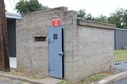
Titan II ICBM Launch Complex 373-5 Site |
|
000000002000-03-06-0000March 6, 2000
(#00000100) |
Approximately 0.5 miles (0.80 km) northeast of Highway 36
35°15′34″N 91°51′26″W / 35.259444°N 91.857222°W / 35.259444; -91.857222 (Titan II ICBM Launch Complex 373-5 Site) |
Center Hill |
|
| 179 |
Titus House |
|
000000001991-09-05-0000September 5, 1991
(#91001240) |
406 E. Center St.
35°14′56″N 91°44′00″W / 35.248889°N 91.733333°W / 35.248889; -91.733333 (Titus House) |
Searcy |
|
| 180 |
Trinity Episcopal Church |
|
000000001992-07-23-0000July 23, 1992
(#91001199) |
Junction of N. Elm and Market Sts.
35°14′59″N 91°44′25″W / 35.249722°N 91.740278°W / 35.249722; -91.740278 (Trinity Episcopal Church) |
Searcy |
|
| 181 |
Walker Homestead Historic District |
|
000000001992-07-20-0000July 20, 1992
(#91001351) |
County Road 56 east of its junction with Highway 267
35°11′16″N 91°46′35″W / 35.187778°N 91.776389°W / 35.187778; -91.776389 (Walker Homestead Historic District) |
Garner |
|
| 182 |
Otha Walker Homestead |
|
000000001992-07-23-0000July 23, 1992
(#91001354) |
Highway 36
35°12′12″N 91°36′27″W / 35.203230°N 91.607464°W / 35.203230; -91.607464 (Otha Walker Homestead) |
West Point |
|
| 183 |
Ward-Stout House |
|
000000001991-09-05-0000September 5, 1991
(#91001313) |
Junction of Front and Walnut Sts.
35°25′23″N 91°27′15″W / 35.423056°N 91.454167°W / 35.423056; -91.454167 (Ward-Stout House) |
Bradford |
|
| 184 |
Watkins House |
|
000000001991-09-05-0000September 5, 1991
(#91001182) |
1208 E. Race St.
35°15′03″N 91°43′25″W / 35.250833°N 91.723611°W / 35.250833; -91.723611 (Watkins House) |
Searcy |
|
| 185 |
Tom Watkins House |
|
000000001991-09-05-0000September 5, 1991
(#91001183) |
Junction of Oak and Race Sts.
35°15′03″N 91°44′01″W / 35.250833°N 91.733611°W / 35.250833; -91.733611 (Tom Watkins House) |
Searcy |
|
| 186 |
William Henry Watson Homestead |
|
000000001992-07-20-0000July 20, 1992
(#91001308) |
County Road 68 south of Denmark
35°26′32″N 91°35′23″W / 35.442222°N 91.589722°W / 35.442222; -91.589722 (William Henry Watson Homestead) |
Denmark |
Demolished.
|
| 187 |
Weber House |
Upload image |
000000001991-09-05-0000September 5, 1991
(#91001272) |
Elm St.
35°21′46″N 91°30′36″W / 35.362778°N 91.51°W / 35.362778; -91.51 (Weber House) |
Russell |
Burned down.
|
| 188 |
Albert Whisinant House |
Upload image |
000000001992-07-23-0000July 23, 1992
(#91001297) |
Highway 16 north of Mountain Home
35°24′02″N 91°49′08″W / 35.400556°N 91.818889°W / 35.400556; -91.818889 (Albert Whisinant House) |
Mountain Home |
|
| 189 |
White County Courthouse |
|
000000001977-08-03-0000August 3, 1977
(#77000279) |
Court Sq.
35°15′17″N 91°44′16″W / 35.254722°N 91.737778°W / 35.254722; -91.737778 (White County Courthouse) |
Searcy |
|
| 190 |
Wilburn House |
|
000000001991-09-05-0000September 5, 1991
(#91001177) |
707 E. Race St.
35°15′02″N 91°43′48″W / 35.250556°N 91.73°W / 35.250556; -91.73 (Wilburn House) |
Searcy |
|
| 191 |
Williams House |
Upload image |
000000001992-07-23-0000July 23, 1992
(#91001353) |
Junction of Highway 267 and County Road 54
35°13′44″N 91°45′00″W / 35.228889°N 91.75°W / 35.228889; -91.75 (Williams House) |
Searcy |
No longer standing.
|
| 192 |
Arthur Williams Homestead, Feed Storage Shed |
Upload image |
000000001992-07-23-0000July 23, 1992
(#91001321) |
Falwell Rd.
35°25′15″N 91°27′50″W / 35.420833°N 91.463889°W / 35.420833; -91.463889 (Arthur Williams Homestead, Feed Storage Shed) |
Bradford |
|
| 193 |
Jack Wood House |
|
000000001989-11-02-0000November 2, 1989
(#89001939) |
Judson Ave.
35°16′49″N 91°38′14″W / 35.280278°N 91.637222°W / 35.280278; -91.637222 (Jack Wood House) |
Judsonia |
|
| 194 |
Arthur W. Woodson House |
|
000000001991-09-05-0000September 5, 1991
(#91001211) |
1005 W. Arch Ave.
35°15′00″N 91°44′51″W / 35.25°N 91.7475°W / 35.25; -91.7475 (Arthur W. Woodson House) |
Searcy |
|
| 195 |
Dalton Woodson House |
|
000000001991-09-05-0000September 5, 1991
(#91001212) |
1007 W. Arch Ave.
35°15′00″N 91°44′54″W / 35.25°N 91.748333°W / 35.25; -91.748333 (Dalton Woodson House) |
Searcy |
|
| 196 |
Avanell Wright House |
|
000000001991-09-05-0000September 5, 1991
(#91001291) |
Junction of Main and Pine Sts.
35°25′38″N 91°50′07″W / 35.427222°N 91.835278°W / 35.427222; -91.835278 (Avanell Wright House) |
Pangburn |
|
| 197 |
Jim Wright Farmstead Historic District |
|
000000001991-09-05-0000September 5, 1991
(#91001284) |
Highway 258 east of its junction with Highway 323
35°21′14″N 91°37′10″W / 35.353889°N 91.619444°W / 35.353889; -91.619444 (Jim Wright Farmstead Historic District) |
Bald Knob |
|

.JPG)


.JPG)
.JPG)


.JPG)