National Register of Historic Places listings in Cass County, Minnesota

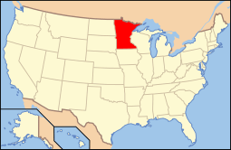
Location of Cass County in Minnesota
This is a list of the National Register of Historic Places listings in Cass County, Minnesota. It is intended to be a complete list of the properties and districts on the National Register of Historic Places in Cass County, Minnesota, United States. The locations of National Register properties and districts for which the latitude and longitude coordinates are included below, may be seen in an online map.
There are 19 properties and districts listed on the National Register in the county. A supplementary list includes two additional sites that were formerly listed on the National Register.
- This National Park Service list is complete through NPS recent listings posted December 16, 2016.[1]
Current listings
| [2] | Name on the Register | Image | Date listed[3] | Location | City or town | Description |
|---|---|---|---|---|---|---|
| 1 | Battle Point (21CA12) | 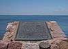 |
(#90001144) |
6 mi (9.7 km) west of County Highway 8 on Leech Lake in Battleground State Forest 47°09′52″N 94°18′33″W / 47.164444°N 94.309167°W |
Leech Lake Indian Reservation | Site of the 1898 Battle of Sugar Point, the last engagement between Native Americans and the U.S. military, which prompted changes in federal timber management. Also contains burials and archaeological resources from precontact Siouan and postcontact Ojibwe occupations.[4] |
| 2 | Brainerd and Northern Minnesota–Minnesota and International Railway Depot |  |
(#12000459) |
102 Barclay Ave. W. 46°43′02″N 94°24′14″W / 46.71709°N 94.403973°W |
Pine River | 1895 railway station that led to the establishment of Pine River on a major new logging route laid by the Brainerd and Northern Minnesota Railway.[5] |
| 3 | Chase Hotel |  |
(#80001994) |
329 Cleveland Ave. 47°06′12″N 94°35′00″W / 47.103404°N 94.583214°W |
Walker | 1922 example of the first-class resort hotels built in Cass County at the dawn of the automobile era.[6] |
| 4 | Chippewa Agency Historic District |  |
(#73000967) |
Address restricted[7] |
Pillager vicinity | Location of a key indian agency active 1851–1869, hub of the region's mid-19th-century activity. District also includes the sites of a prehistoric mound and village, an early road, the first logging camp on the Crow Wing River, and Hole in the Day's assassination in 1868.[8] |
| 5 | Conservation Building | |
(#02001706) |
205 Minnesota Ave. 47°06′05″N 94°34′42″W / 47.101425°N 94.578308°W |
Walker | Unique example—built 1934–36—of the municipal facilities funded by New Deal federal relief programs, featuring a visitor center, wildlife museum, rock garden, and offices used by numerous New Deal services.[9] |
| 6 | Crow Wing State Park |  |
(#70000288) |
Off Minnesota Highway 371 46°16′39″N 94°20′40″W / 46.2775°N 94.344444°W |
Pillager vicinity | Long-used site at a key travel junction associated with the Dakota/Ojibwe territorial conflict and the early town of Old Crow Wing, whose abandonment in the 1880s uniquely preserves the succession of the Native American, fur trade, and logging eras. Extends into Crow Wing and Morrison Counties.[10] |
| 7 | Great Northern Railway Company Bridge |  |
(#80001990) |
Southwest of Cass Lake off Minnesota Highway 371 47°16′07″N 94°37′40″W / 47.268637°N 94.627862°W |
Cass Lake vicinity | Railroad bridge built circa 1915 with a swing section to accommodate lumber shipping on the Steamboat River, representing the interplay of the logging and railroad industries in northern Minnesota.[11] Now carries the Heartland State Trail. |
| 8 | Gull Lake Mounds Site |  |
(#73000968) |
Gull Lake Recreation Area[12] 46°24′43″N 94°21′05″W / 46.411944°N 94.351389°W |
Pillager vicinity | Rare surviving mound group in a rapidly developing resort region, with 12 complete burial mounds dating from 800 BCE–200 CE and 500–900 CE.[13] |
| 9 | Hole-in-the-Day House Site | |
(#73000969) |
Address restricted[7] |
Pillager vicinity | Site of an early-1850s farmhouse built for prominent Ojibwe leader Hole in the Day (c. 1825–1868), who espoused strategic enculturation as a way to advance tribal interests.[14] |
| 10 | Minnesota State Sanatorium for Consumptives |  |
(#01000766) |
7232 Ah-Gwah-Ching Rd., NW. 47°04′11″N 94°34′12″W / 47.069722°N 94.57°W |
Walker vicinity | Minnesota's most significant tuberculosis treatment center, also known as Ah-Gwah-Ching; in operation 1906–1962.[15] Demolished in 2008.[16] |
| 11 | Old Backus | |
(#74001009) |
Address restricted[7] |
Backus vicinity | Long-used habitation site containing evidence of Late Woodland period seasonal villages, historical Ojibwe burials, a logging camp established in 1885, and the original townsite of Backus (abandoned in 1902).[17] |
| 12 | Pine River to Woman Lake and Longville Stagecoach Road-Widow Lake Segment Historic District | |
(#14000908) |
Address restricted[7] |
Hackensack vicinity | Only intact segment of an early road which, from 1890 to 1930, was an essential conduit in opening the area to logging, homesteading, and outdoor recreation.[18] |
| 13 | Rice Lake Hut Rings | |
(#73000970) |
Address restricted[7] |
Pillager vicinity | Four large depressions thought to be remnants of Native American earth lodges from the Contact era or just prior.[19] |
| 14 | Sherwood Forest Lodge Complex |  |
(#80001992) |
County Highway 77 46°29′08″N 94°21′39″W / 46.485688°N 94.360918°W |
Lake Shore | Highly intact example of north-central Minnesota's early lake resorts, with a main lodge and 20 cabins built around 1929. Also noted for its finely crafted rustic architecture.[20] |
| 15 | Soo Line Depot | |
(#80001993) |
Off Main St. 47°03′25″N 93°55′06″W / 47.056864°N 93.91845°W |
Remer | Circa-1910 railway station noted as a well-preserved example of the Soo Line's standard second-class depots and for its associations with the establishment and development of Remer.[21] |
| 16 | South Pike Bay Site | |
(#13001111) |
South Pike Bay Campground, Chippewa National Forest[22] 47°19′47″N 94°35′09″W / 47.329628°N 94.585783°W |
Cass Lake vicinity | Beach terraces on Cass Lake yielding extensive archaeological resources from repeated encampment during the Late Paleoindian/Early Archaic transition and again throughout the Woodland period.[23] |
| 17 | Supervisor's Office Headquarters | 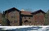 |
(#76001049) |
200 Ash Ave. NW 47°22′45″N 94°36′51″W / 47.379282°N 94.614303°W |
Cass Lake | 1935 headquarters of Chippewa National Forest, significant for its chinkless log construction in traditional Scandinavian style and its association with the federal work relief projects of the New Deal.[24] |
| 18 | Winnibigoshish Lake Dam |  |
(#82004629) |
County Highway 9 at the Mississippi River 47°25′47″N 94°03′04″W / 47.42959°N 94.051192°W |
Bena vicinity | Dam built 1899–1900, associated with the first and largest of the reservoirs created in the region as a federal project to control the flow of the Upper Mississippi River. Extends into Itasca County.[25] |
| 19 | Winnibigoshish Resort | 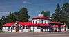 |
(#80001989) |
1510 U.S. Route 2 47°20′44″N 94°12′31″W / 47.345535°N 94.208737°W |
Bena | Eye-catching 1933 gas station and motel complex, a rare well-preserved example of a business built to attract early highway travelers.[26] Now the Big Winnie General Store and RV Park.[27] |
Former listings
| [2] | Name on the Register | Image | Date listed | Date removed | Location | City or town | Summary |
|---|---|---|---|---|---|---|---|
| 1 | Julius Neils House | Upload image | (#80001991) | North 3rd Street |
Cass Lake | 1900 frame house of a lumber entrepreneur.[28] Burned down in 2005.[29] | |
| 2 | Sixth Street Commercial Building | Upload image | (#80001995) | 525 6th St. |
Walker | 1910 brick store.[30] Demolished in 1985.[28] |
See also
- List of National Historic Landmarks in Minnesota
- National Register of Historic Places listings in Minnesota
References
- ↑ "National Register of Historic Places: Weekly List Actions". National Park Service, United States Department of the Interior. Retrieved on December 16, 2016.
- 1 2 Numbers represent an ordering by significant words. Various colorings, defined here, differentiate National Historic Landmarks and historic districts from other NRHP buildings, structures, sites or objects.
- ↑ The eight-digit number below each date is the number assigned to each location in the National Register Information System database, which can be viewed by clicking the number.
- ↑ Hohman-Caine, Christy A. (1990-03-01). "National Register of Historic Places Registration Form: Battle Point" (PDF). National Park Service. Retrieved 2016-04-23.
- ↑ Kellner, Debra (January 2012). "National Register of Historic Places Registration Form: Brainerd and Northern Minnesota/Minnesota and International Railway Depot (draft)" (PDF). National Park Service. Retrieved 2016-04-17.
- ↑ Frame III, Robert M. (1980-03-19). "National Register of Historic Places Inventory—New Hotel Chase" (PDF). National Park Service. Retrieved 2016-04-10.
- 1 2 3 4 5 Federal and state laws and practices restrict general public access to information regarding the specific location of sensitive archeological sites in many instances. The main reasons for such restrictions include the potential for looting, vandalism, or trampling. See: Knoerl, John; Miller, Diane; Shrimpton, Rebecca H. (1990), Guidelines for Restricting Information about Historic and Prehistoric Resources, National Register Bulletin (29), National Park Service, U.S. Department of the Interior, OCLC 20706997.
- ↑ Mitchell, Diana. "National Register of Historic Places Inventory – Nomination Form: Chippewa Agency Historic District". National Park Service.
- ↑ Anderson, Rolf T.; Melanie Mullins (2002-08-15). "National Register of Historic Places Registration Form: Conservation Building" (PDF). National Park Service. Retrieved 2016-04-10.
- ↑ Grossman, John (1970-03-06). "National Register of Historic Places Inventory – Nomination Form: Crow Wing State Park" (PDF). National Park Service. Retrieved 2016-04-10.
- ↑ Frame III, Robert M. (April 1980). "National Register of Historic Places Inventory–Nomination Form: Great Northern Railway Company Bridge" (PDF). National Park Service. Retrieved 2016-02-28.
- ↑ Location derived from "Facility Details". Gull Lake Recreation Area, MN. Recreation.gov. 2014. Retrieved 2016-03-20. NRIS lists site as "address restricted".
- ↑ Johnson, Elden (1970-04-16). "National Register of Historic Places Inventory – Nomination Form: Gull Lake Mound Site". National Park Service.
- ↑ Zeik, Susan; Douglas George (1973-04-17). "National Register of Historic Places Inventory – Nomination Form: Hole-in-the-Day II Cabin Site". National Park Service.
- ↑ Anderson, Rolf T. (1996-09-27). "National Register of Historic Places Registration Form: Minnesota State Sanatorium for Consumptives" (PDF). National Park Service. Retrieved 2016-02-28.
- ↑ Lundquist, Monica (2010-11-10). "Ah-Gwah-Ching: Land ready and waiting for a developer". Brainerd Dispatch. Brainerd, Minn. Retrieved 2012-11-19.
- ↑ Zeik, Susan; Douglas George (1973-04-16). "National Register of Historic Places Inventory – Nomination Form: Old Backus". National Park Service.
- ↑ "Stagecoach Road (1890-1930) on National Register" (PDF). Cass County Clippings. Cass County Museum. January 2015. Retrieved 2016-09-17.
- ↑ Zeik, Susan; Douglas George (1973-04-12). "National Register of Historic Places Inventory – Nomination Form: Rice Lake Hut Rings". National Park Service.
- ↑ Frame III, Robert M. (March 1980). "National Register of Historic Places Inventory—Nomination Form: Sherwood Forest Lodge Complex" (PDF). National Park Service. Retrieved 2016-02-28.
- ↑ Frame III, Robert M. (1980-03-19). "National Register of Historic Places Inventory—Nomination Form: Minneapolis, St. Paul, and Sault Ste. Marie Railway Company Depot" (PDF). National Park Service. Retrieved 2016-02-28.
- ↑ Location derived from LeVasseur, Andrea K. (2003). "Profiles, Mystery Bones, and Pots: The South Pike Bay Site" (PDF). The Minnesota Archaeologist. 62: 85–98. Retrieved 2014-01-31. NRIS lists site as "address restricted".
- ↑ Foss, Jacob (2013-04-30). "National Register of Historic Places Registration Form: South Pike Bay Site". National Park Service.
- ↑ Johnson, Stanley A. (1975-07-30). "National Register of Historic Places Inventory -- Nomination Form: Supervisor's Office, Chippewa National Forest" (PDF). National Park Service. Retrieved 2016-02-28.
- ↑ Haidet, Mark (March 1981). "National Register of Historic Places Inventory—Nomination Form: Winnibigoshish Lake Dam" (PDF). National Park Service. Retrieved 2016-02-27.
- ↑ Frame III, Robert M. (1980-03-19). "National Register of Historic Places Inventory—Nomination Form: Winnibigoshish Resort" (PDF). National Park Service. Retrieved 2016-02-27.
- ↑ "Big Winnie Store RV Park & Campground". Retrieved 2016-02-27.
- 1 2 Nord, Mary Ann (2003). The National Register of Historic Places in Minnesota. Minnesota Historical Society. ISBN 0-87351-448-3.
- ↑ "Changes to the National Register of Historic Places in Minnesota, 2003-2010". Minnesota State Historic Preservation Office. 2011-02-01. Retrieved 2013-03-01.
- ↑ "Sixth Street Commercial Building". Minnesota National Register Properties Database. Minnesota Historical Society. 2009. Retrieved 2012-11-19.
External links
| Wikimedia Commons has media related to National Register of Historic Places in Cass County, Minnesota. |
- Minnesota National Register Properties Database—Minnesota Historical Society

This article is issued from Wikipedia - version of the 11/21/2016. The text is available under the Creative Commons Attribution/Share Alike but additional terms may apply for the media files.