National Register of Historic Places listings in Le Sueur County, Minnesota
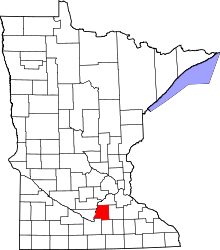
Location of Le Sueur County in Minnesota
This is a list of the National Register of Historic Places listings in Le Sueur County, Minnesota. It is intended to be a complete list of the properties and districts on the National Register of Historic Places in Le Sueur County, Minnesota, United States. The locations of National Register properties and districts for which the latitude and longitude coordinates are included below, may be seen in an online map.[1]
There are 26 properties and districts listed on the National Register in the county. A supplementary list includes two additional sites that were formerly on the National Register.
- This National Park Service list is complete through NPS recent listings posted December 16, 2016.[2]
Current listings
| [3] | Name on the Register | Image | Date listed[4] | Location | City or town | Description |
|---|---|---|---|---|---|---|
| 1 | John R. Andrews House | Upload image | (#78003123) |
County Highway 19 44°17′07″N 93°54′33″W / 44.285278°N 93.909167°W |
Kasota | c. 1860 house of the nationally famous Andrews Opera Company family.[5] As of April 15, 2013 this house is no longer at its listed location and is presumed destroyed.[6] |
| 2 | Bridge No. 4846 (1) | Upload image | (#81000681) |
County Highway 102 over Minnesota Highway 22 (original location) Current coordinates are 44°15′59″N 93°53′54″W / 44.266342°N 93.898301°W |
Kasota | 1875 metal Pratt through truss bridge, the oldest example of its type on a Minnesota highway.[5] In 1984 it was moved to Lake Washington County Park for use as a pedestrian bridge; this move was not approved and may have caused it to be de-listed.[7] |
| 3 | Broadway Bridge | 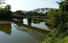 |
(#99000934) |
Minnesota Highway 99 over the Minnesota River 44°19′29″N 93°57′11″W / 44.324719°N 93.953024°W |
Ottawa Township | 1931 through truss bridge.[5] Extends into Nicollet County. |
| 4 | Carson H. Cosgrove House | 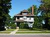 |
(#82004694) |
228 S. 2nd 44°27′32″N 93°54′58″W / 44.458989°N 93.916108°W |
Le Sueur | c. 1895 Victorian house of Carson Nesbit Cosgrove, head of Green Giant.[5] |
| 5 | Arthur Dehn House | 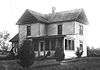 |
(#82000561) |
Herbert St. 44°13′26″N 93°34′29″W / 44.223889°N 93.574722°W |
Waterville | Home of artist Adolf Dehn (typo led to "Alfred" Dehn on register) from 1914 to 1930.[5] As of April 15, 2013 this house is no longer at its listed location and is presumed destroyed.[8] |
| 6 | Dodd Road Discontiguous District | 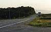 |
(#03000520) |
County Road 148 west of Cleveland; County Road 136 from MN 13 to Cordova 44°19′39″N 93°37′47″W / 44.327548°N 93.629823°W |
Cleveland and Kilkenny vicinities | Two segments of a privately funded road built between Mendota and St. Peter in 1853, a key transportation artery in early south-central Minnesota. A third segment lies in Rice County.[9] |
| 7 | Elysian Public School | 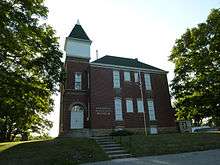 |
(#81000677) |
Northwest corner of NE Frank Ave. and NE 2nd St. 44°12′03″N 93°40′26″W / 44.200943°N 93.673806°W |
Elysian | 1895 brick school.[5] |
| 8 | First National Bank | 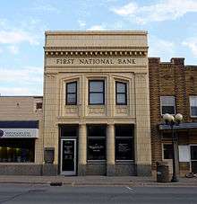 |
(#82004703) |
112 E. Main 44°32′36″N 93°34′35″W / 44.543427°N 93.576503°W |
New Prague | 1922 Renaissance Revival bank with a terracotta façade.[5] |
| 9 | Geldner Sawmill | 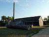 |
(#75000991) |
County Highway 13 44°16′29″N 93°44′38″W / 44.274799°N 93.743758°W |
Cleveland | c. 1860 sawmill.[5] Now a county park.[10] |
| 10 | German Evangelical Salem Church | 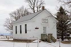 |
(#82004696) |
County Road 156 44°29′08″N 93°47′19″W / 44.485549°N 93.788474°W |
Le Sueur | 1870 frame Greek Revival church of a German immigrant congregation.[5] |
| 11 | Hilltop Hall | 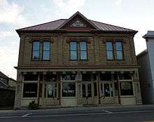 |
(#82004701) |
206 N. 1st St. 44°26′25″N 93°34′53″W / 44.440195°N 93.58142°W |
Montgomery | c. 1892 brick commercial building also housing a dance hall.[5] |
| 12 | Hotel Broz | 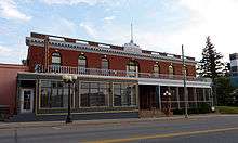 |
(#82004704) |
212 W. Main 44°32′36″N 93°34′49″W / 44.543419°N 93.580274°W |
New Prague | 1898 brick Georgian Revival hotel.[5] |
| 13 | Kasota Township Hall | 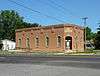 |
(#81000679) |
Hill and Rice Sts. 44°17′32″N 93°57′55″W / 44.292348°N 93.96524°W |
Kasota | 1889 brick municipal hall with Kasota limestone trim.[5] |
| 14 | Kasota Village Hall | 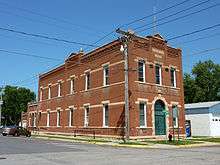 |
(#81000680) |
Cherry and Webster Sts. 44°17′29″N 93°58′00″W / 44.291317°N 93.966747°W |
Kasota | 1898 brick Queen Anne municipal hall/fire station with Kasota limestone trim.[5] |
| 15 | Le Sueur County Courthouse and Jail | 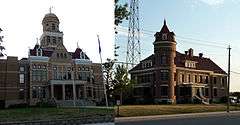 |
(#81000682) |
88 S. Park Ave. and 130 S. Park Ave. 44°23′18″N 93°43′56″W / 44.388198°N 93.732093°W |
Le Center | 1896 brick Richardsonian Romanesque courthouse with Kasota limestone trim and 1914 brick jail designed by Albert Schippel.[5] |
| 16 | Dr. William W. Mayo House | 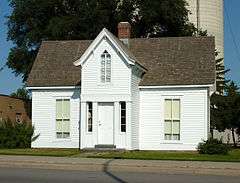 |
(#69000074) |
118 N. Main St. 44°27′44″N 93°54′54″W / 44.462136°N 93.915108°W |
Le Sueur | 1859 clapboard house of William Worrall Mayo, father of the Mayo Clinic's founders, and later owned by Carson Nesbit Cosgrove, head of Green Giant. Now a Minnesota Historical Society museum.[11] |
| 17 | Methodist Episcopal Church | 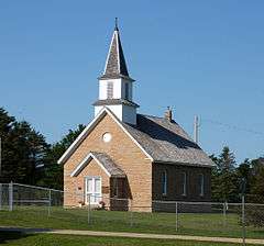 |
(#82004697) |
Liberty and Whittier St. 44°23′03″N 93°56′53″W / 44.384033°N 93.947958°W |
Ottawa | 1859 limestone Greek Revival church.[12] Also known as the Little Stone Church. |
| 18 | Needham-Hayes House | 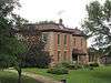 |
(#82004698) |
Off Railroad St. 44°22′57″N 93°56′38″W / 44.382459°N 93.943845°W |
Le Sueur | c. 1870 brick house with limestone trim of a notable local settler.[5] |
| 19 | Ottawa Township Hall | 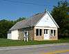 |
(#82004705) |
Buchanan and Bryant Sts. 44°23′00″N 93°56′47″W / 44.38335°N 93.9463°W |
Ottawa | 1860 limestone Greek Revival municipal hall.[13] |
| 20 | John Rinshed House | 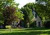 |
(#82004707) |
Sumner and Whittier Sts. 44°22′56″N 93°56′53″W / 44.382312°N 93.947958°W |
Ottawa | 1870 limestone house.[14] |
| 21 | Charles Schwartz House and Barn |  |
(#82004708) |
Off County Highway 23 44°23′36″N 93°56′53″W / 44.393358°N 93.948174°W |
Ottawa | 1870 limestone house and barn.[15] |
| 22 | Smith-Cosgrove House | 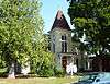 |
(#82004700) |
228 S. Main St. 44°27′34″N 93°55′02″W / 44.45952°N 93.917342°W |
Le Sueur | c. 1878 brick Second Empire house.[5] |
| 23 | George W. Taylor House | 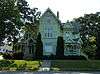 |
(#75000992) |
103 S. 2nd St. 44°27′38″N 93°54′51″W / 44.460563°N 93.914039°W |
Le Sueur | 1890 Eastlake Movement house of a merchant and his wife, who was president of the national Women's Relief Corps organization.[5] |
| 24 | Trinity Chapel-Episcopal | 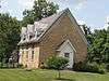 |
(#82004695) |
Sumner and Exchange Sts. 44°22′56″N 93°56′58″W / 44.382172°N 93.949543°W |
Ottawa | 1861 limestone Gothic Revival chapel.[16] |
| 25 | Union Hotel | 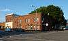 |
(#82004709) |
201 Paquin St., E. 44°13′05″N 93°34′03″W / 44.217942°N 93.567554°W |
Waterville | 1888 brick Italianate hotel.[5] |
| 26 | Westerman Lumber Office and House | 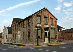 |
(#82004702) |
201 S. 1st St. 44°26′15″N 93°34′51″W / 44.437611°N 93.580919°W |
Montgomery | 1895 house and office of lumberman Henry E. Westerman.[5] Now houses a restaurant and roadside attraction.[17] |
Former listings
| [3] | Name on the Register | Image | Date listed | Date removed | Location | City or town | Summary |
|---|---|---|---|---|---|---|---|
| 1 | Elysian Water Tower | 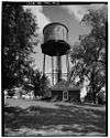 |
(#81000678) | Frank Street |
Elysian | 1895 water tower. Demolished in 1989 to make way for a modern replacement.[18] | |
| 2 | David Patten Farmhouse | Upload image | (#82004706) | Liberty Street |
Ottawa | 1863 limestone house.[19] Demolished in 2002.[20] |
See also
- List of National Historic Landmarks in Minnesota
- National Register of Historic Places listings in Minnesota
References
- ↑ The latitude and longitude information provided in this table was derived originally from the National Register Information System, which has been found to be fairly accurate for about 99% of listings. For about 1% of NRIS original coordinates, experience has shown that one or both coordinates are typos or otherwise extremely far off; some corrections may have been made. A more subtle problem causes many locations to be off by up to 150 yards, depending on location in the country: most NRIS coordinates were derived from tracing out latitude and longitudes off of USGS topographical quadrant maps created under the North American Datum of 1927, which differs from the current, highly accurate WGS84 GPS system used by most on-line maps. Chicago is about right, but NRIS longitudes in Washington are higher by about 4.5 seconds, and are lower by about 2.0 seconds in Maine. Latitudes differ by about 1.0 second in Florida. Some locations in this table may have been corrected to current GPS standards.
- ↑ "National Register of Historic Places: Weekly List Actions". National Park Service, United States Department of the Interior. Retrieved on December 16, 2016.
- 1 2 Numbers represent an ordering by significant words. Various colorings, defined here, differentiate National Historic Landmarks and historic districts from other NRHP buildings, structures, sites or objects.
- ↑ The eight-digit number below each date is the number assigned to each location in the National Register Information System database, which can be viewed by clicking the number.
- 1 2 3 4 5 6 7 8 9 10 11 12 13 14 15 16 17 18 19 Nord, Mary Ann (2003). The National Register of Historic Places in Minnesota. Minnesota Historical Society. ISBN 0-87351-448-3.
- ↑ Personal visit compared to: Lynne VanBrocklin Spaeth, National Register of Historic Places Inventory -- Nomination Form, National Park Service, June 22, 1977; copy accessed from "Andrews, John R., House" file, State Historic Preservation Office in the Minnesota History Center.
- ↑ Various documents in the "Bridge No. 4846 (1)" file, State Historic Preservation Office in the Minnesota History Center.
- ↑ Personal visit compared to: Britta Bloomberg, Minnesota Historic Properties Inventory Form, National Park Service, August 1980; copy accessed from "Dehn, Adolf, House" file, State Historic Preservation Office in the Minnesota History Center.
- ↑ Godfrey, Anthony (2002-09-30). "National Register of Historic Places Registration Form: Dodd Road" (PDF). National Park Service. Retrieved 2013-08-21.
- ↑ "Le Sueur County Lakes/Parks/Rivers". Le Sueuer County. 2012-08-13. Retrieved 2013-02-09.
- ↑ Hanson, Krista Finstad (2007). Minnesota Open House: A Guide to Historic House Museums. St. Paul, Minn.: Minnesota Historical Society Press. ISBN 978-0-87351-577-1.
- ↑ "Ottawa Stone Buildings: Methodist Episcopal Church". Minnesota National Register Properties Database. Minnesota Historical Society. 2009. Retrieved 2013-02-08.
- ↑ "Ottawa Stone Buildings: Ottawa Township Hall". Minnesota National Register Properties Database. Minnesota Historical Society. 2009. Retrieved 2013-02-08.
- ↑ "Ottawa Stone Buildings: Rinshed, John, House". Minnesota National Register Properties Database. Minnesota Historical Society. 2009. Retrieved 2013-02-08.
- ↑ "Ottawa Stone Buildings: Schwartz, Charles, House and Barn". Minnesota National Register Properties Database. Minnesota Historical Society. 2009. Retrieved 2013-02-08.
- ↑ "Ottawa Stone Buildings: Trinity Chapel (Episcopal)". Minnesota National Register Properties Database. Minnesota Historical Society. 2009. Retrieved 2013-02-08.
- ↑ Grimm, John. "Big HonzaLand". Retrieved 2013-02-12.
- ↑ El-Hai, Jack (2000). Lost Minnesota: Stories of Vanished Places. Minneapolis: University of Minnesota Press. ISBN 0816635153.
- ↑ "Ottawa Stone Buildings: David Patten, House (removed)". Minnesota National Register Properties Database. Minnesota Historical Society. 2009. Retrieved 2013-02-08.
- ↑ "Changes to the National Register of Historic Places in Minnesota, 2003-2010". Minnesota State Historic Preservation Office. 2011-02-01. Retrieved 2013-03-01.
External links
| Wikimedia Commons has media related to National Register of Historic Places in Le Sueur County, Minnesota. |
- Minnesota National Register Properties Database—Minnesota Historical Society
| Topics | |
|---|---|
| Lists by states |
|
| Lists by insular areas | |
| Lists by associated states | |
| Other areas | |
| |
Municipalities and communities of Le Sueur County, Minnesota, United States | ||
|---|---|---|
| Cities | | |
| Townships | ||
| Unincorporated communities | ||
| Footnotes | ‡This populated place also has portions in an adjacent county or counties | |
This article is issued from Wikipedia - version of the 8/19/2016. The text is available under the Creative Commons Attribution/Share Alike but additional terms may apply for the media files.