Nainital
| Nainital नैनीताल | |
|---|---|
| Hill station | |
|
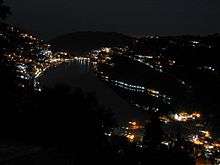
View of Nainital Lake City | |
 Nainital  Nainital Location in Uttarakhand, India | |
| Coordinates: 29°23′42″N 79°26′56″E / 29.395°N 79.449°ECoordinates: 29°23′42″N 79°26′56″E / 29.395°N 79.449°E | |
| Country | India |
| State | Uttarakhand |
| District | Nainital |
| Elevation | 2,084 m (6,837 ft) |
| Population (2011) | |
| • Total | 41,377 |
| Languages | |
| • Official | Hindi, Urdu, Punjabi |
| • Other | Kumauni |
| Time zone | IST (UTC+5:30) |
| PIN | 263001/263002 |
| Telephone code | +91 - 5942 |
| Vehicle registration | UK 04 |
| Website |
nainital |

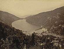
Nainital ![]() pronunciation is a popular hill station in the Indian state of Uttarakhand and headquarters of Nainital district in the Kumaon foothills of the outer Himalayas. Situated at an altitude of 2,084 metres (6,837 ft) above sea level, Nainital is set in a valley containing a pear-shaped lake, approximately two miles in circumference, and surrounded by mountains, of which the highest are Naina (2,615 m (8,579 ft)) on the north, Deopatha (2,438 m (7,999 ft)) on the west, and Ayarpatha (2,278 m (7,474 ft)) on the south. From the tops of the higher peaks, "magnificent views can be obtained of the vast plain to the south, or of the mass of tangled ridges lying north, bounded by the great snowy range which forms the central axis of the Himalayas."[1]
pronunciation is a popular hill station in the Indian state of Uttarakhand and headquarters of Nainital district in the Kumaon foothills of the outer Himalayas. Situated at an altitude of 2,084 metres (6,837 ft) above sea level, Nainital is set in a valley containing a pear-shaped lake, approximately two miles in circumference, and surrounded by mountains, of which the highest are Naina (2,615 m (8,579 ft)) on the north, Deopatha (2,438 m (7,999 ft)) on the west, and Ayarpatha (2,278 m (7,474 ft)) on the south. From the tops of the higher peaks, "magnificent views can be obtained of the vast plain to the south, or of the mass of tangled ridges lying north, bounded by the great snowy range which forms the central axis of the Himalayas."[1]
Geography and climate

Nainital is located at 29°23′N 79°27′E / 29.38°N 79.45°E.[2] The slopes of the nearby mountains are most populated, with an elevation ranging from 1,940–2,100 m (6,360–6,890 ft). The highest point nearby is Naina Peak or China Peak, with an elevation of 2,619 m (8,593 ft).
Nainital has temperate summers, maximum temperature 27 °C (81 °F); minimum temperature 7 °C (45 °F), during which its population increases more than fivefold with an annual influx of tourists predominantly from the plains of northern India. In winter, Nainital receives snowfall between December and February with the temperatures varying between a maximum of 15 °C (59 °F) and a minimum of −3 °C (27 °F).
Its climate is classified as subtropical highland (Cwb) according to Köppen-Geiger system.
| Climate data for Nainital | |||||||||||||
|---|---|---|---|---|---|---|---|---|---|---|---|---|---|
| Month | Jan | Feb | Mar | Apr | May | Jun | Jul | Aug | Sep | Oct | Nov | Dec | Year |
| Average high °C (°F) | 9.4 (48.9) |
11.2 (52.2) |
15.5 (59.9) |
19.9 (67.8) |
23.2 (73.8) |
22.9 (73.2) |
20.1 (68.2) |
19.6 (67.3) |
19.3 (66.7) |
18 (64) |
15.4 (59.7) |
12.4 (54.3) |
17.24 (63) |
| Daily mean °C (°F) | 5.2 (41.4) |
6.8 (44.2) |
10.6 (51.1) |
15 (59) |
18.2 (64.8) |
18.6 (65.5) |
17.2 (63) |
16.8 (62.2) |
15.9 (60.6) |
13.6 (56.5) |
10.6 (51.1) |
7.8 (46) |
13.03 (55.45) |
| Average low °C (°F) | 1.1 (34) |
2.4 (36.3) |
5.7 (42.3) |
10.1 (50.2) |
13.3 (55.9) |
14.4 (57.9) |
14.3 (57.7) |
14 (57) |
12.6 (54.7) |
9.3 (48.7) |
5.9 (42.6) |
3.2 (37.8) |
8.86 (47.92) |
| Average precipitation mm (inches) | 64 (2.52) |
56 (2.2) |
60 (2.36) |
35 (1.38) |
67 (2.64) |
178 (7.01) |
443 (17.44) |
381 (15) |
241 (9.49) |
76 (2.99) |
8 (0.31) |
27 (1.06) |
1,636 (64.4) |
| Source: Climate-Data.org[3] | |||||||||||||
Demographics
As of the 2011 Indian census, Nainital had a population of 41,377.[4] Males constitute 52.3% of the population and females 47.7%. In 2011, Nainital had an average literacy rate of 92.93%, higher than the Uttarakhand state average of 78.82%.[4] In Nainital, 9.54% of the population is under 6 years of age. Kumaoni people form the major part of the town's population along with people from all over India.
Mythology
It is believed that the Naini Lake is one of the 64 Shakti Peeths, or religious sites where parts of the charred body of Sati (Parvati) fell on earth while being carried by Lord Shiva.[5] The spot where Sati's eyes (or Nain) fell, came to be called Nain-tal or lake of the eye. The goddess Shakti is worshiped at the Naina Devi Temple on the north shore of the present day lake.[6][7]
History
Early construction
The Kumaon Hills came under British rule after the Anglo-Nepalese War (1814–16). The hill station town of Naini Tal was founded only in 1841, with the construction of the first European house (Pilgrim Lodge) by P. Barron, a sugar trader from Shahjahanpur. In his memoir, he wrote: "It is by far the best site I have witnessed in the course of a 1,500 miles (2,400 km) trek in the Himalayas."[8] In 1846, when a Captain Madden of the Bengal Artillery visited Naini Tal, he recorded that "houses were rapidly springing up in most parts of the settlement: some towards the crest of the limitary ranges were nearly 7,500 ft (2,300 m) above sea level: the rugged and woody Anyarpatta Aashish (Anyar-patt – in Kumaoni means – complete blackout. The reason for this nomenclature by the locals was because there were minimal sun rays due to its location and dense forests) was being gradually planted and that the favourite sites were on the undulating tract of forest land which stretched back from the head of the lake to the base of China and Deopatta (Camel's Hump). The church, St. John in the Wilderness, was one of the earliest buildings in Nainital, followed by Belvedere, Alma lodge, Ashdale Cottage(1860)..."[9] Soon, the town became a health resort favoured by British soldiers and by colonial officials and their families trying to escape the heat of the plains. Later, the town became the summer residence of the governor of the United Provinces.
The landslip of 1880

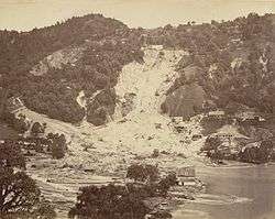
In September 1880 a landslide ('the landslip of 1880') occurred at the north end of the town, burying 151 people. The first known landslide had occurred in 1866, and in 1879 there was a larger one at the same spot, Alma Hill, but "the great slip occurred in the following year, on Saturday 18 September 1880."[9]
"Two days preceding the slip there was heavy rain, ... 20 inches (510 mm) to 35 in (890 mm) fell during the 40 hours ending on Saturday morning, and the downpour still lasted and continued for hours after the slip. This heavy fall naturally brought down streams of water from the hill side, some endangering the Victoria Hotel, ... (which) was not the only building threatened ... Bell's shop, the Volunteer Orderly Room and the Hindu (Naina Devi) temple were scenes of labour with a view to diverting streams. At a quarter to two the landslip occurred burying those in and around the buildings mentioned above."[9]
The number of dead and missing were 108 Indian and 43 British nationals. (See poem by Hannah Battersby on the page Literary references to Nainital.) The Assembly Rooms and the Naina Devi Temple were destroyed in the disaster. A recreation area known as 'The Flats' was later built on the site and a new temple was erected. To prevent further disasters, storm water drains were constructed and building bylaws were made stricter.
Establishment of schools
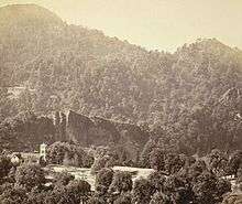
.jpg)
In the latter half of the 19th century a number of "European" schools for boys and girls were founded in Nainital. During the Victorian and Edwardian eras, students in these schools consisted largely of children of British colonial officials or soldiers. The Diocesan Girls' High School, now known as All Saints' College, was established in 1869, near where the High Court of Uttarakhand stands today. By 1906, there were over half a dozen such schools,[9] including the Diocesan Boys' School (later renamed Sherwood College) and the Philander Smith's college (later renamed Halett War School, currently Birla Vidya Mandir).
St. Joseph's College, Nainital, a day-boarding and residential school built by Irish brothers in 1888, celebrated its 125th anniversary in 2013. St. Joseph's College is popularly known as SEM. Another important school was St. Mary's Convent, popularly known as Ramnee, in 1878 which celebrated its 125th anniversary in year 2003.
Libraries
There are a number of libraries in the Nainital area. Among them are the Durga Lal Shah Municipal Public Library, on the Mall, founded in 1934;[10] the Uttarakhand Academy of Administration, Library and Documentation Center, Mallital;[11] the ARIES Observatory Library;[12] and the Kumaon University Library, Nainital.[13]
Famous people
- Elsie Inglis, physician and social reformer
- Jim Corbett, hunter of man-eating tigers, author, conservationist and namesake of Jim Corbett National Park. Educated at St. Joseph's College.
- Govind Ballabh Pant, statesman and leader of India's independence movement, first Indian Premier of British India, the first Chief Minister of Uttar Pradesh and the third Home Minister of India
- Sam Manekshaw, Indian Army Chief of Staff during Indo-Pakistani War of 1971. Educated at Sherwood College.
- Som Nath Sharma, India's first Param Vir Chakra award winner. Educated at Sherwood College.
- Krishna Chandra Pant, former Deputy Chairman of the Planning Commission of India. Educated at St. Joseph's College.
- Rajendra K. Pachauri, chairman of the Intergovernmental Panel on Climate Change
- Sudhir Kakar, renowned psychoanalyst
- Shivani, Hindi poet
- Anup Jalota, singer
- Sukirti Kandpal, TV actress
- Amitabh Bachchan, Bollywood actor. Educated at Sherwood College.
- Naseeruddin Shah, Bollywood actor. Educated at St. Joseph's College.
- Kabir Bedi, Bollywood Actor. Educated at Sherwood College.
- Danny Denzongpa, Bollywood actor studied in Birla Vidya Mandir
- Nirmal Pandey, Bollywood actor and singer
- Dilip Tahil, Bollywood actor. Educated at Sherwood College.
- Manish Pandey, cricketer who plays for Karnataka and Bangalore
- Eric Maturin, British actor
- Lalit Modi, Indian Premier League (IPL) chairman. Educated at St. Joseph's College.
- Narayan Dutt Tiwari, Indian leader and politician, former Governor of Andhra Pradesh, former Chief Minister of Uttarakhand and Uttar Pradesh, and former Finance Minister of India.
- Hastings Ismay, 1st Baron Ismay, first secretary general of NATO
- Percy Hobart, British major general and military engineer
- Orde Charles Wingate, British general and commander of the Chindits in Burma during World War II
- Nilesh Misra, famous lyricist. Educated at St. Joseph's College.
Gallery

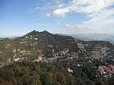 Nainital overview
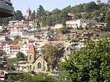 Urban Areas
 The Mall Road, 2006.
 Ramlila Bhawan, Mallital, Nainital.
 A view from Hotel Naini Retreat's Balcony.
.jpg) Naini Lake after snowfall (2007)
Naini Lake after snowfall (2007) Nainital lake in the morning
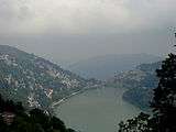 Nainital in May 2011
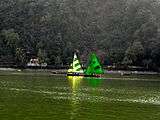 Yachts in Naini Lake in March 2011
 Nainital Lake in 2009.
 Statue of Govind Ballabh Pant, at Mall Road, Nainital.
 Golu Devta temple, at Ghorakhal near Nainital.
 Naini Lake
 Boats on the Lake.
 Gurney House-the home of Jim Corbett
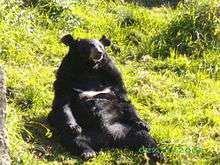 A Bear in the Pt. G B Pant High Altitude Zoo, Nainital.
 Naina Devi Temple, after which the place gets its name.
See also
- Bhullatal Lake
- St. Joseph's College, Nainital
- Literary references to Nainital
- Aryabhatta Research Institute of Observational Sciences
Notes and references
- ↑ Nainital District, The Imperial Gazetteer of India, volume 18, pp. 322–323. 1908
- ↑ Falling Rain Genomics, Inc – Nainital. Fallingrain.com.
- ↑ "Climate: Nainital – Climate graph, Temperature graph, Climate table". Climate-Data.org. Retrieved 27 August 2013.
- 1 2 Nainital Population Census 2011.
- ↑ http://www.kmvn.gov.in/details/index/63
- ↑ File:View of Mallital, without the present Naina Devi Temple, Nainital, 1865.jpg British Library.
- ↑ File:View of Nainital, from the southeast (Tallital side), 1865.jpg British Library.
- ↑ (Pilgrim 1844)
- 1 2 3 4 (Murphy 1906)
- ↑ Singh, Sarina (2005). Lonely Planet: India (Nainital). ISBN 1-74059-694-3. Page 425.
- ↑ The World Bank India: Depository Libraries, 2006.
- ↑ Astronomical Networking Libraries Archived 17 July 2006 at the Wayback Machine.
- ↑ Kumaon University
- Bateman, Josiah (1860), The Life of The Right Rev. Daniel Wilson, D.D., Late Lord Bishop of Calcutta and Metropolitan of India, Volume II, John Murray, Albemarle Street, London.
- Corbett, SAYUJ (2002) [2000], Inter H.G.S – Indian Culture in Daily Life., Oxford India Reprint
- Corbett, Jim (2002) [1948], The Man Eating Leopard of Rudraprayag, Oxford India Reprint
- Corbett, Jim (2002) [1954], The Temple Tigers and More Man-Eaters of Kumaon, Oxford India Reprint
- Fayrer, Joseph (1900), Recollections of my life, William Blackwood and Sons, Edinburgh and London
- Imperial Gazeteer of India (1908), Imperial Gazeteer of India, Volume 18, pp. 322–323., Oxford University Press, Oxford and London
- Kennedy, Dane (1996), The Magic Mountains: Hill Stations and the British Raj, University of California Press, Berkeley, Los Angeles, and Oxford. 264 pages.
- Kipling, Rudyard (1889), The Story of the Gadsbys, Macmillan and Company, London
- Kipling, Rudyard (1895), Under the Deodars, Macmillan and Company, London
- McLaren, Eva Shaw (1920), Elsie Inglis: The Woman with the Torch, Macmillan and Company, New York
- M'Crindle, J.W. (1901), Ancient India: As Described in Classical Literature, Archibald ConstaHble & Company, Westminster
- Murphy, C.W. (1906), A Guide to Naini Tal and Kumaun, Allahbad, United Provinces
- Notes on Wanderings in the Himmala, containing descriptions of some of the grandest scenery of the snowy range, among others of Naini Tal, Agra Akhbaar Press, Agra
External links
| Wikimedia Commons has media related to Nainital. |
| Wikisource has the text of the 1911 Encyclopædia Britannica article Naini Tal. |
- Official website
- Official web-site of Uttarakhand Government
-
 Nainital travel guide from Wikivoyage
 - Nainital on Instagram