Champawat district
| Champawat district चम्पावत जिला | |
|---|---|
| District | |
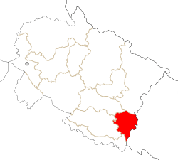 Location in Uttarakhand, India | |
| Coordinates: 29°20′N 80°06′E / 29.33°N 80.10°ECoordinates: 29°20′N 80°06′E / 29.33°N 80.10°E | |
| Country |
|
| State | Uttarakhand |
| Division | Kumaon |
| Headquarters | Champawat |
| Area | |
| • Total | 1,781 km2 (688 sq mi) |
| Population | |
| • Total | 224,542 |
| • Density | 126/km2 (330/sq mi) |
| Languages | |
| • Official | Hindi |
| Time zone | IST (UTC+05:30) |
| Vehicle registration | UK |
| Website |
champawat |
Champawat district is a district of Uttarakhand state in northern India. The town of Champawat is the administrative headquarters. The district of Champawat constituted in the year 1997. The district is divided into five tehsils: Barakot, Champawat, Lohaghat, Pati, Purnagiri.
Champawat district is part of the eastern Kumaon division of Uttarakhand. It is bounded on the north by Pithoragarh district, on the east by Nepal, on the south by Udham Singh Nagar district, on the west by Nainital district, and on the northwest by Almora district.
As of 2011 it is the second least populous of the 13 districts of Uttarakhand, after Rudraprayag.[1]
Economy
In 2006 the Ministry of Panchayati Raj named Champawat one of the country's 250 most backward districts (out of a total of 640 districts).[2] It is one of the three districts in Uttarakhand currently receiving funds from the Backward Regions Grant Fund Programme (BRGF).[2]
Assembly Constituencies
- Lohaghat
- Champawat
Demographics
According to the 2011 census, Champawat district has a population of 259,315,[1] roughly equal to the nation of Vanuatu.[3] This gives it a ranking of 579th among the 640 districts of India.[1] The district has a population density of 147 inhabitants per square kilometre (380/sq mi).[1] Its population growth rate over the decade 2001–2011 was 15.49%.[1] Champawat district has a sex ratio of 981 females for every 1000 males,[1] and a literacy rate of 80.73%.[1]
As of the 2001 Indian census, the Champawat district had a population of 224,542, including 216,646 Hindus (96.5%), 6,642 (3.0%) Muslims, and 626 (0.3%) Christians.[4]
References
- 1 2 3 4 5 6 7 "District Census 2011". Census2011.co.in. 2011. Retrieved 2011-09-30.
- 1 2 Ministry of Panchayati Raj (September 8, 2009). "A Note on the Backward Regions Grant Fund Programme" (PDF). National Institute of Rural Development. Archived from the original (PDF) on April 5, 2012. Retrieved September 27, 2011.
- ↑ US Directorate of Intelligence. "Country Comparison:Population". Retrieved 2011-10-01.
Vanuatu 224,564 July 2011 est.
- ↑ "Uttarakhand - Districts of India: Know India". National Portal of India. Archived from the original on 2009-02-19. Retrieved 2009-04-04.
External links
| Wikimedia Commons has media related to Champawat district. |
 |
Almora district | Pithoragarh district | | |
| Nainital district | |
| ||
| ||||
| | ||||
| Udham Singh Nagar district |