Mount Zirkel
| Mount Zirkel | |
|---|---|
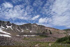 View of West face of Mt. Zirkel in Mt. Zirkel Wilderness in northern Colorado, taken from Fryingpan Basin | |
| Highest point | |
| Elevation | 12,185 ft (3,714 m) [1][2] |
| Prominence | 3,470 ft (1,058 m) [2] |
| Isolation | 37.66 mi (60.61 km) [2] |
| Listing | Colorado county high points 36th |
| Coordinates | 40°49′52″N 106°39′47″W / 40.831208°N 106.663105°WCoordinates: 40°49′52″N 106°39′47″W / 40.831208°N 106.663105°W [3] |
| Geography | |
 Mount Zirkel | |
| Location | Jackson County and the high point of Routt County, Colorado, U.S.[2] |
| Parent range |
Highest summit of the Park Range[2] |
| Topo map |
USGS 7.5' topographic map Mount Zirkel, Colorado[3] |
| Climbing | |
| Easiest route | hike |
Mount Zirkel is the highest summit of the Park Range of the Rocky Mountains of North America. The prominent 12,185-foot (3,714 m) peak is located in the Mount Zirkel Wilderness of Routt National Forest, 25.9 miles (41.7 km) north-northeast (bearing 19°) of the City of Steamboat Springs, Colorado, United States, on the Continental Divide between Jackson and Routt counties.[1][2][3] Mount Zirkel was named in honor of German geologist Ferdinand Zirkel.[3]
Mountain
See also
References
- 1 2 The elevation of Mount Zirkel includes an adjustment of +1.632 m (+5.35 ft) from NGVD 29 to NAVD 88.
- 1 2 3 4 5 6 "Mount Zirkel, Colorado". Peakbagger.com. Retrieved October 21, 2014.
- 1 2 3 4 "Mount Zirkel". Geographic Names Information System. United States Geological Survey. Retrieved October 21, 2014.
External links

This article is issued from Wikipedia - version of the 1/16/2016. The text is available under the Creative Commons Attribution/Share Alike but additional terms may apply for the media files.