McGee, Missouri
| McGee | |
|---|---|
| Unincorporated community | |
 McGee Location within the state of Missouri | |
| Coordinates: 37°04′28″N 90°11′44″W / 37.07444°N 90.19556°WCoordinates: 37°04′28″N 90°11′44″W / 37.07444°N 90.19556°W | |
| Country | United States |
| State | Missouri |
| County | Wayne |
| Elevation | 387 ft (118 m) |
| Time zone | Central (CST) (UTC-6) |
| • Summer (DST) | CDT (UTC-5) |
| ZIP codes | 63763 |
| GNIS feature ID | 741053[1] |
McGee is an unincorporated community in eastern Wayne County, Missouri, United States. It is located twenty-three miles northeast of Poplar Bluff in the Mark Twain National Forest. The zip code is 63763. The elevation is 387 feet (118 m).
References
Municipalities and communities of Wayne County, Missouri, United States | ||
|---|---|---|
| Cities | 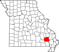 | |
| Village | ||
| Townships |
| |
| Unincorporated communities | ||
This article is issued from Wikipedia - version of the 9/5/2016. The text is available under the Creative Commons Attribution/Share Alike but additional terms may apply for the media files.