Cascade, Missouri
| Cascade | |
|---|---|
| Unincorporated community | |
 Cascade Location within the state of Missouri | |
| Coordinates: 37°17′58″N 90°16′09″W / 37.29944°N 90.26917°WCoordinates: 37°17′58″N 90°16′09″W / 37.29944°N 90.26917°W | |
| Country | United States |
| State | Missouri |
| County | Wayne |
| Elevation | 525 ft (160 m) |
| Time zone | Central (CST) (UTC-6) |
| • Summer (DST) | CDT (UTC-5) |
| ZIP codes | old 63632 closed in 2004 or 05 |
| GNIS feature ID | 715465[1] |
Cascade is an unincorporated community in northeastern Wayne County, Missouri, United States. It is located on Missouri Supplemental Route M about eighteen miles west of Marble Hill.
History
It was established sometime in the 1880s on a portion of the farm of Dr. L. M. Wagner, a professor and the pastor of the nearby Zion Lutheran church. Dr. Wagner an ambitious young minister persuaded to come to Missouri from the Kentucky Synod to help heal the broken congregation at the end of the Civil War. The professor named the community in reference to the series of cascades in a nearby creek. The community of Cascade prospered for several decades serving as the North end of a 16-mile railroad spur, established to transport the surrounding acres of Virgin Pine timber to the mills at Greenville. By the beginning of the 20th century Cascade had surpassed its neighbor a mile to the east, the original Lutheran community of Gravelton. Cascade could not only boast of a train depot but also a hotel, bank, furniture factory, several stores and a village telephone system. The professor had also erected on the church property, a two-story four room, educational building. Establishing a board of directors and chartering with the state of Missouri "Concordia College" a school of higher education equivalent of today's junior college.
References
Municipalities and communities of Wayne County, Missouri, United States | ||
|---|---|---|
| Cities | 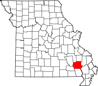 | |
| Village | ||
| Townships |
| |
| Unincorporated communities | ||