Mayfield, Utah
| Mayfield, Utah | |
|---|---|
| Town | |
 Location in Sanpete County and the state of Utah. | |
| Coordinates: 39°7′10″N 111°42′34″W / 39.11944°N 111.70944°WCoordinates: 39°7′10″N 111°42′34″W / 39.11944°N 111.70944°W | |
| Country | United States |
| State | Utah |
| County | Sanpete |
| Area | |
| • Total | 0.8 sq mi (2.2 km2) |
| • Land | 0.8 sq mi (2.2 km2) |
| • Water | 0.0 sq mi (0.0 km2) |
| Elevation | 5,538 ft (1,688 m) |
| Population (2012) | |
| • Total | 499 |
| • Density | 501.7/sq mi (193.7/km2) |
| Time zone | Mountain (MST) (UTC-7) |
| • Summer (DST) | MDT (UTC-6) |
| ZIP code | 84643 |
| Area code(s) | 435 |
| FIPS code | 49-48720[1] |
| GNIS feature ID | 1443237[2] |
Mayfield is a town in Sanpete County, Utah, United States. The population was 420 at the 2000 census.
History
Mayfield was settled in 1871.[3] Some of the area's founding families included the Andersons, Petersons, Petersen's, Bartholomews, Jensens, Sorensen's and Willdens. When the first white settlers came they found out that this area was considered sacred by the Indians who said it was a " healing Ground". It is said that no fighting has ever occurred in Mayfield.
Geography
According to the United States Census Bureau, the town has a total area of 0.8 square miles (2.2 km²), all of it land.
Demographics
| Historical population | |||
|---|---|---|---|
| Census | Pop. | %± | |
| 1880 | 330 | — | |
| 1890 | 337 | 2.1% | |
| 1900 | 469 | 39.2% | |
| 1910 | 485 | 3.4% | |
| 1920 | 550 | 13.4% | |
| 1930 | 467 | −15.1% | |
| 1940 | 473 | 1.3% | |
| 1950 | 390 | −17.5% | |
| 1960 | 329 | −15.6% | |
| 1970 | 267 | −18.8% | |
| 1980 | 397 | 48.7% | |
| 1990 | 438 | 10.3% | |
| 2000 | 420 | −4.1% | |
| 2010 | 496 | 18.1% | |
| Est. 2015 | 521 | [4] | 5.0% |
As of the census[1] of 2000, there were 420 people, 141 households, and 106 families residing in the town. The population density was 501.7 people per square mile (193.1/km²). There were 164 housing units at an average density of 195.9 per square mile (75.4/km²). The racial makeup of the town was 97.62% White, 1.67% Native American, 0.48% from other races, and 0.24% from two or more races. Hispanic or Latino of any race were 1.19% of the population.
There were 141 households out of which 34.0% had children under the age of 18 living with them, 66.0% were married couples living together, 6.4% had a female householder with no husband present, and 24.8% were non-families. 22.7% of all households were made up of individuals and 14.2% had someone living alone who was 65 years of age or older. The average household size was 2.71 and the average family size was 3.24.
In the town the population was spread out with 26.7% under the age of 18, 5.5% from 18 to 24, 21.2% from 25 to 44, 23.3% from 45 to 64, and 23.3% who were 65 years of age or older. The median age was 43 years. For every 100 females there were 88.3 males. For every 100 females age 18 and over, there were 81.2 males.
The median income for a household in the town was $41,500, and the median income for a family was $46,250. Males had a median income of $28,750 versus $21,875 for females. The per capita income for the town was $16,748. About 2.7% of families and 3.8% of the population were below the poverty line, including none of those under age 18 and 15.2% of those age 65 or over.
References
- 1 2 "American FactFinder". United States Census Bureau. Archived from the original on September 11, 2013. Retrieved 2008-01-31.
- ↑ "US Board on Geographic Names". United States Geological Survey. 2007-10-25. Retrieved 2008-01-31.
- ↑ Andrew Jenson. Encyclopedic History of the Church. p. 484
- ↑ "Annual Estimates of the Resident Population for Incorporated Places: April 1, 2010 to July 1, 2015". Retrieved July 2, 2016.
- ↑ "Census of Population and Housing". Census.gov. Archived from the original on May 11, 2015. Retrieved June 4, 2015.
External links
- Official website
 Mayfield (Utah) travel guide from Wikivoyage
 |
Gunnison | Sterling | Manti-La Sal National Forest / Orangeville | |
| Centerfield | |
Manti-La Sal National Forest / Clawson Ferron | ||
| ||||
| | ||||
| Redmond Salina |
Fish Lake Loa, Lyman |
Manti-La Sal National Forest / Emery |
Municipalities and communities of Sanpete County, Utah, United States | ||
|---|---|---|
| Cities | 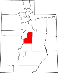 | |
| Towns | ||
| Unincorporated communities | ||
| Ghost towns | ||