Marytown, Wisconsin
| Marytown, Wisconsin | |
|---|---|
| Unincorporated community | |
|
Looking south at Marytown, Wisconsin | |
 Marytown, Wisconsin  Marytown, Wisconsin | |
| Coordinates: 43°54′49″N 88°12′08″W / 43.91361°N 88.20222°WCoordinates: 43°54′49″N 88°12′08″W / 43.91361°N 88.20222°W | |
| Country | United States |
| State | Wisconsin |
| County | Fond du Lac |
| Elevation | 965 ft (294 m) |
| Time zone | Central (CST) (UTC-6) |
| • Summer (DST) | CDT (UTC-5) |
| Zip codes | 53061 |
| Area code(s) | 920 |
| GNIS feature ID | 1569109[1] |
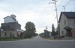
Marytown, Wisconsin is an unincorporated community in Fond du Lac County, Wisconsin, in the town of Calumet.[2] Marytown is located at the intersection of Fond du Lac County highways G and HH. Wisconsin Highway 149 ran north to south through the community before it was decommissioned in 2006.
Holyland

Marytown is in an area of eastern Fond du Lac County, Wisconsin known as "The Holyland", so called because of the large number of communities built around churches, including St. Anna, St. Peter, St. Cloud, Mount Calvary, Johnsburg, Calvary, Brothertown and Jericho.
A recognizable feature in Marytown is St. Mary's Roman Catholic Church,[3] which is located at the peak of the largest hill in the area. The church is lit at night, and can be see from several miles away (depending on the terrain).
History
A post office was established in Marytown in 1854,[4] but was later closed.
On July 18, 1996, several houses at the north end of Marytown were destroyed and one person killed by a tornado. This was part of a statewide outbreak of tornadoes on the same day as the Oakfield Tornado.[5]
References
- ↑ "US Board on Geographic Names". United States Geological Survey. 2007-10-25. Retrieved 2008-01-31.
- ↑ http://www.wisconsinhistory.org/dictionary/index.asp?action=view&term_id=5115
- ↑ http://www.archmil.org/parishes/ShowParish.asp?ID=145
- ↑ Wulff, Eugene C. The New Holstien Story. p. 16.
- ↑ Wisconsin Tornado Outbreak of July 18, 1996: Formation of Tornadic Supercells, PDF file, Renee Geiser, Retrieved October 9, 2007
External links
Municipalities and communities of Fond du Lac County, Wisconsin, United States | ||
|---|---|---|
| Cities | 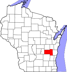 | |
| Villages | ||
| Towns | ||
| CDPs | ||
| Unincorporated communities |
| |
| Ghost towns | ||
| Footnotes | ‡This populated place also has portions in an adjacent county or counties | |