St. Cloud, Wisconsin
| St. Cloud, Wisconsin | |
|---|---|
| Village | |
 Location of St. Cloud, Wisconsin | |
| Coordinates: 43°49′N 88°10′W / 43.817°N 88.167°WCoordinates: 43°49′N 88°10′W / 43.817°N 88.167°W | |
| Country | United States |
| State | Wisconsin |
| County | Fond du Lac |
| Area[1] | |
| • Total | 0.94 sq mi (2.43 km2) |
| • Land | 0.92 sq mi (2.38 km2) |
| • Water | 0.02 sq mi (0.05 km2) |
| Elevation[2] | 932 ft (284 m) |
| Population (2010)[3] | |
| • Total | 477 |
| • Estimate (2012[4]) | 470 |
| • Density | 518.5/sq mi (200.2/km2) |
| Time zone | Central (CST) (UTC-6) |
| • Summer (DST) | CDT (UTC-5) |
| Area code(s) | 920 |
| FIPS code | 55-70500[5] |
| GNIS feature ID | 1572903[2] |
| Website |
www |
St. Cloud is a village in Fond du Lac County, Wisconsin, United States, along the Sheboygan River. The population was 477 at the 2010 census. St. Cloud is part of The Holyland region in northeastern Fond du Lac County.[6]
History
A post office called St. Cloud has been in operation since 1867.[7] The village was named after Saint-Cloud, in France.[8]
Geography
St. Cloud is located at 43°49′N 88°10′W / 43.817°N 88.167°W (43.822, -88.167), in the Town of Marshfield (§25 T16N R19E).[9]
According to the United States Census Bureau, the village has a total area of 0.94 square miles (2.43 km2), of which, 0.92 square miles (2.38 km2) of it is land and 0.02 square miles (0.05 km2) is water.[1]
Demographics
| Historical population | |||
|---|---|---|---|
| Census | Pop. | %± | |
| 1880 | 183 | — | |
| 1910 | 309 | — | |
| 1920 | 367 | 18.8% | |
| 1930 | 365 | −0.5% | |
| 1940 | 353 | −3.3% | |
| 1950 | 408 | 15.6% | |
| 1960 | 530 | 29.9% | |
| 1970 | 550 | 3.8% | |
| 1980 | 560 | 1.8% | |
| 1990 | 494 | −11.8% | |
| 2000 | 497 | 0.6% | |
| 2010 | 477 | −4.0% | |
| Est. 2015 | 460 | [10] | −3.6% |
2010 census
As of the census[3] of 2010, there were 477 people, 208 households, and 143 families residing in the village. The population density was 518.5 inhabitants per square mile (200.2/km2). There were 216 housing units at an average density of 234.8 per square mile (90.7/km2). The racial makeup of the village was 96.9% White, 0.6% Native American, 0.4% Asian, 1.5% from other races, and 0.6% from two or more races. Hispanic or Latino of any race were 2.7% of the population.
There were 208 households of which 26.0% had children under the age of 18 living with them, 58.7% were married couples living together, 5.8% had a female householder with no husband present, 4.3% had a male householder with no wife present, and 31.3% were non-families. 26.9% of all households were made up of individuals and 13% had someone living alone who was 65 years of age or older. The average household size was 2.29 and the average family size was 2.76.
The median age in the village was 43.3 years. 20.3% of residents were under the age of 18; 5.1% were between the ages of 18 and 24; 28.5% were from 25 to 44; 29.8% were from 45 to 64; and 16.4% were 65 years of age or older. The gender makeup of the village was 48.6% male and 51.4% female.
2000 census
As of the census[5] of 2000, there were 497 people, 184 households, and 130 families residing in the village. The population density was 533.9 people per square mile (206.3/km²). There were 193 housing units at an average density of 207.3 per square mile (80.1/km²). The racial makeup of the village was 99.60% White, 0.20% Native American, 0.20% from other races. Hispanic or Latino of any race were 0.80% of the population.
There were 184 households out of which 34.8% had children under the age of 18 living with them, 63.6% were married couples living together, 4.9% had a female householder with no husband present, and 29.3% were non-families. 22.3% of all households were made up of individuals and 13.0% had someone living alone who was 65 years of age or older. The average household size was 2.70 and the average family size was 3.25.
In the village the population was spread out with 27.0% under the age of 18, 9.5% from 18 to 24, 29.0% from 25 to 44, 19.3% from 45 to 64, and 15.3% who were 65 years of age or older. The median age was 36 years. For every 100 females there were 91.2 males. For every 100 females age 18 and over, there were 97.3 males.
The median income for a household in the village was $51,964, and the median income for a family was $56,625. Males had a median income of $36,563 versus $21,618 for females. The per capita income for the village was $20,539. About 2.4% of families and 4.5% of the population were below the poverty line, including 3.1% of those under age 18 and 7.5% of those age 65 or over.
Notable people
- D. C. Coolidge, Wisconsin State Assemblyman, was born in St. Cloud.[12]
- Robert W. Monk, Wisconsin State Senator, lived in St. Cloud.[13]
Images
 Village hall and fire station
 Roman Catholic church
 Looking north at downtown St. Cloud
 Looking north at downtown St. Cloud
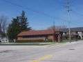 St. Cloud Post Office
 Water tower
References
- 1 2 "US Gazetteer files 2010". United States Census Bureau. Retrieved 2012-11-18.
- 1 2 "US Board on Geographic Names". United States Geological Survey. 2007-10-25. Retrieved 2008-01-31.
- 1 2 "American FactFinder". United States Census Bureau. Retrieved 2012-11-18.
- ↑ "Population Estimates". United States Census Bureau. Retrieved 2013-06-24.
- 1 2 "American FactFinder". United States Census Bureau. Retrieved 2008-01-31.
- ↑ http://www.archmil.org/parishes/ShowParish.asp?ID=150
- ↑ "Fond du Lac County". Jim Forte Postal History. Retrieved 28 March 2015.
- ↑ Chicago and North Western Railway Company (1908). A History of the Origin of the Place Names Connected with the Chicago & North Western and Chicago, St. Paul, Minneapolis & Omaha Railways. p. 121.
- ↑ "US Gazetteer files: 2010, 2000, and 1990". United States Census Bureau. 2011-02-12. Retrieved 2011-04-23.
- ↑ "Annual Estimates of the Resident Population for Incorporated Places: April 1, 2010 to July 1, 2015". Retrieved July 2, 2016.
- ↑ "Census of Population and Housing". Census.gov. Retrieved June 4, 2015.
- ↑ THE BLUE BOOK OF THE STATE OF WISCONSIN. Madison, Wis. 1909. pp. 1116–1117.
- ↑ 'Wisconsin Blue Book 1915,' Biographical Sketch of Robert W. Monk, pg. 497
External links
| Wikimedia Commons has media related to St. Cloud, Wisconsin. |
Municipalities and communities of Fond du Lac County, Wisconsin, United States | ||
|---|---|---|
| Cities | 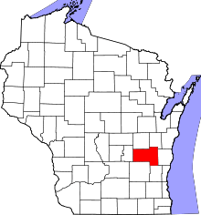 | |
| Villages | ||
| Towns | ||
| CDPs | ||
| Unincorporated communities |
| |
| Ghost towns | ||
| Footnotes | ‡This populated place also has portions in an adjacent county or counties | |