Khojavend (town)
Coordinates: 39°47′43″N 47°06′47″E / 39.79528°N 47.11306°E
| Khojavend Martuni | |
|---|---|
|
View from Martuni | |
 Khojavend Martuni | |
| Coordinates: 39°47′43″N 47°06′47″E / 39.79528°N 47.11306°E | |
| Country |
De jure De facto |
| Region District |
Martuni Khojavend |
| Elevation | 390 m (1,280 ft) |
| Population (2015) | |
| • Total | 5,700 [1] |
| Time zone | UTC (UTC+4) |
| Area code(s) | (+374) 478 |

Khojavend (Azerbaijani: Xocavənd, Martuni (Armenian: Մարտունի)) is a town and the provincial capital of Martuni Region of the de facto independent but unrecognized Nagorno-Karabakh Republic. It is located approximately 41 kilometers east of the republic's capital of Stepanakert. It has a population of 5,700 as of 2015. [2]
History
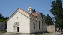
Excavations in Khojavand have uncovered a number of tombs dating to the Neolithic and Bronze Ages. Khojavand is also home to several ruined medieval churches and remains of settlements, and khachkars have also been preserved.[3]
During Soviet times, Khojavand was the capital of the eponymous district located in the Nagorno-Karabakh Autonomous Oblast. The population of the town, grouped into kolkhozes, largely occupied itself with raising livestock, grape growing, wheat cultivation, and gardening.[3]
Khojavend, and the district itself, became a frontline city during the latter stages of the Nagorno-Karabakh War. In early February 1992, Vazgen Sargsyan, the then Defence Minister of Armenia, appointed Monte Melkonian as Chief of Headquarters and assigned him to lead the defense of Martuni and the surrounding regions.[4] Melkonian, who remained as regional commander until he was killed in combat in June 1993, and the forces under him were able to halt and prevent the Azerbaijani military from occupying the district throughout the entirety of the war.
Climate
| Climate data for Martuni, Nagorno-Karabakh Republic | |||||||||||||
|---|---|---|---|---|---|---|---|---|---|---|---|---|---|
| Month | Jan | Feb | Mar | Apr | May | Jun | Jul | Aug | Sep | Oct | Nov | Dec | Year |
| Average high °F (°C) | 41.9 (5.5) |
43.5 (6.4) |
50.2 (10.1) |
63.5 (17.5) |
71.1 (21.7) |
79.9 (26.6) |
85.6 (29.8) |
85.5 (29.7) |
76.6 (24.8) |
66.4 (19.1) |
54.7 (12.6) |
46.4 (8.0) |
63.78 (17.65) |
| Average low °F (°C) | 28.9 (−1.7) |
30.2 (−1.0) |
35.2 (1.8) |
45.7 (7.6) |
53.8 (12.1) |
61.5 (16.4) |
67.1 (19.5) |
65.1 (18.4) |
59.4 (15.2) |
50.4 (10.2) |
40.8 (4.9) |
33.1 (0.6) |
47.6 (8.67) |
| Average precipitation inches (mm) | 0.79 (20) |
1.02 (26) |
1.42 (36) |
1.93 (49) |
2.68 (68) |
2.17 (55) |
0.91 (23) |
0.91 (23) |
1.1 (28) |
1.73 (44) |
1.22 (31) |
0.98 (25) |
16.86 (428) |
| Source: http://en.climate-data.org/location/21894/ | |||||||||||||
Twin towns – Sister cities
Martuni is twinned with:
-
 Les Pennes-Mirabeau, France:[5] Les Pennes-Mirabeau and Martuni became sister cities on 11 June 2013.[6]
References
- ↑ http://stat-nkr.am/files/publications/2015/LXH_tverov_2015.pdf
- ↑ http://stat-nkr.am/files/publications/2015/LXH_tverov_2015.pdf
- 1 2 (Armenian) Anon. «Մարտունի» (Martuni). Armenian Soviet Encyclopedia. vol. vii. Yerevan: Armenian Academy of Sciences, 1981, p. 352.
- ↑ See Markar Melkonian (2005). My Brother's Road: An American's Fateful Journey to Armenia. New York: I.B. Tauris, pp. 207ff. ISBN 1-85043-635-5.
- ↑ President of the Nagorno-Karabakh Repoublic (NKR) Bako Sahakyan received on Wednesday a delegation of the French Les Pennes-Mirabeau city headed by its mayor Michel Amiel
- ↑ Les Pennes-Mirabeau and Martuni became sister cities
| Capital city | ||
|---|---|---|
| Regions | ||
| Provincial capitals | ||
| Other urban communities | ||
1 Claimed by the Nagorno-Karabakh Republic but partly under Azerbaijani control. | ||