Manahawkin, New Jersey
| Manahawkin, New Jersey | |
|---|---|
| Census-designated place | |
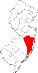
 Map of Manahawkin CDP in Ocean County. Inset: Location of Ocean County in New Jersey. | |
| Coordinates: 39°41′36″N 74°15′01″W / 39.693472°N 74.250229°WCoordinates: 39°41′36″N 74°15′01″W / 39.693472°N 74.250229°W | |
| Country |
|
| State |
|
| County | Ocean |
| Township | Stafford |
| Area[1] | |
| • Total | 1.923 sq mi (4.979 km2) |
| • Land | 1.827 sq mi (4.731 km2) |
| • Water | 0.096 sq mi (0.248 km2) 4.98% |
| Elevation[2] | 23 ft (7 m) |
| Population (2010 Census)[3] | |
| • Total | 2,303 |
| • Density | 1,260.7/sq mi (486.8/km2) |
| Time zone | Eastern (EST) (UTC-5) |
| • Summer (DST) | Eastern (EDT) (UTC-4) |
| ZIP code | 08050[4] |
| Area code(s) | 609 |
| FIPS code | 3442930[1][5] |
| GNIS feature ID | 02390114[1][6][7] |
Manahawkin is an unincorporated community and census-designated place (CDP) located within Stafford Township, in Ocean County, New Jersey, United States.[8][9][10] As of the 2010 United States Census, the CDP's population was 2,303.[3] Manahawkin has been thought to be a Lenape word meaning "land of good corn", although this has been disputed by recent scholars claiming that it translates to "fertile land sloping into the water."[11]
Manahawkin is the gateway to the resort communities on Long Beach Island, with Route 72 providing the sole road access, ending in Ship Bottom as it crosses Manahawkin Bay via the Manahawkin Bay Bridge (formally known as the Dorland J. Henderson Memorial Bridge).
Geography
According to the United States Census Bureau, the CDP had a total area of 1.923 square miles (4.979 km2), including 1.827 square miles (4.731 km2) of it is land and 0.096 square miles (0.248 km2) of water (4.98%) is water.[1][12]
Demographics
| Historical population | |||
|---|---|---|---|
| Census | Pop. | %± | |
| 1990 | 1,594 | — | |
| 2000 | 2,004 | 25.7% | |
| 2010 | 2,303 | 14.9% | |
| Population sources: 1990-2010[10] 2000[13] 2010[3] | |||
Census 2010
The 2010 United States Census counted 2,303 people, 931 households, and 585.6 families residing in the CDP. The population density was 1,260.7 per square mile (486.8/km2). The CDP contained 1,071 housing units at an average density of 586.3 per square mile (226.4/km2). The racial makeup of the CDP was 91.58% (2,109) White, 0.43% (10) Black or African American, 0.43% (10) Native American, 2.52% (58) Asian, 0.00% (0) Pacific Islander, 4.17% (96) from other races, and 0.87% (20) from two or more races. Hispanics or Latinos of any race were 8.25% (190) of the population.[3]
Out of a total of 931 households, 25.5% had children under the age of 18 living with them, 46.6% were married couples living together, 11.6% had a female householder with no husband present, and 37.1% were non-families. 30.9% of all households were made up of individuals, and 19.2% had someone living alone who was 65 years of age or older. The average household size was 2.47 and the average family size was 3.06.[3]
In the CDP, 20.0% of the population were under the age of 18, 8.5% from 18 to 24, 25.1% from 25 to 44, 29.2% from 45 to 64, and 17.3% who were 65 years of age or older. The median age was 42.7 years. For every 100 females the census counted 87.8 males, but for 100 females at least 18 years old, it was 88.4 males.[3]
Census 2000
As of the 2000 United States Census[5] there were 2,004 people, 757 households, and 555 families residing in the CDP. The population density was 425.1/km2 (1,098.9/mi2). There were 827 housing units at an average density of 175.4/km2 (453.5/mi2). The racial makeup of the CDP was 96.86% White, 0.05% African American, 0.10% Native American, 1.45% Asian, 0.55% from other races, and 1.00% from two or more races. Hispanic or Latino of any race were 1.90% of the population.[13]
There were 757 households out of which 30.5% had children under the age of 18 living with them, 56.4% were married couples living together, 12.8% had a female householder with no husband present, and 26.6% were non-families. 21.7% of all households were made up of individuals and 10.8% had someone living alone who was 65 years of age or older. The average household size was 2.56 and the average family size was 2.97.[13]
In the CDP the population was spread out with 22.9% under the age of 18, 6.9% from 18 to 24, 26.8% from 25 to 44, 25.6% from 45 to 64, and 17.8% who were 65 years of age or older. The median age was 41 years. For every 100 females there were 86.9 males. For every 100 females age 18 and over, there were 86.9 males.[13]
The median income for a household in the CDP was $59,663, and the median income for a family was $62,702. Males had a median income of $53,396 versus $24,688 for females. The per capita income for the CDP was $22,875. About 1.4% of families and 3.4% of the population were below the poverty line, including 1.7% of those under age 18 and 14.7% of those age 65 or over.[13]
Education
For grades K through 6, public school students attend the schools of the Stafford Township School District. For grades 7 through 12, students attend the schools of the Southern Regional School District.
Transportation
NJ Transit provides bus service to Atlantic City on the 559 bus route.[14]
Notable people
People who were born in, residents of, or otherwise closely associated with Manahawkin include:
- Doc Cramer (1905–1990), center fielder who played for four American League teams from 1929 to 1948.[15]
- Mike Gesicki (born 1995), tight end who plays for the Penn State Nittany Lions football team.[16]
- Clark Harris (born 1984), tight end for the Houston Texans who played college football at Rutgers University.[17]
- William A. Newell (1817–1901), Governor of New Jersey who represented the state in the United States House of Representatives.[18]
References
- 1 2 3 4 Gazetteer of New Jersey Places, United States Census Bureau. Accessed July 21, 2016.
- ↑ U.S. Geological Survey Geographic Names Information System: Manahawkin Census Designated Place, Geographic Names Information System. Accessed January 11, 2013.
- 1 2 3 4 5 6 DP-1 - Profile of General Population and Housing Characteristics: 2010 Demographic Profile Data for Manahawkin CDP, New Jersey, United States Census Bureau. Accessed January 11, 2013.
- ↑ Look Up a ZIP Code for Manahawkin, NJ, United States Postal Service. Accessed January 11, 2013.
- 1 2 American FactFinder, United States Census Bureau. Accessed September 4, 2014.
- ↑ US Board on Geographic Names, United States Geological Survey. Accessed September 4, 2014.
- ↑ A Cure for the Common Codes: New Jersey, Missouri Census Data Center. Accessed January 11, 2013.
- ↑ GCT-PH1 - Population, Housing Units, Area, and Density: 2010 - County -- County Subdivision and Place from the 2010 Census Summary File 1 for Ocean County, New Jersey, United States Census Bureau. Accessed January 11, 2013.
- ↑ 2006-2010 American Community Survey Geography for New Jersey, United States Census Bureau. Accessed January 11, 2013.
- 1 2 New Jersey: 2010 - Population and Housing Unit Counts - 2010 Census of Population and Housing (CPH-2-32), United States Census Bureau, August 2012. Accessed January 11, 2013.
- ↑ History of Stafford Township History of Stafford Township, Stafford Township. Accessed November 20, 2011.
- ↑ US Gazetteer files: 2010, 2000, and 1990, United States Census Bureau. Accessed September 4, 2014.
- 1 2 3 4 5 DP-1 - Profile of General Demographic Characteristics: 2000 from the Census 2000 Summary File 1 (SF 1) 100-Percent Data for Manahawkin CDP, New Jersey, United States Census Bureau. Accessed January 11, 2013.
- ↑ Ocean County Bus / Rail Connections, NJ Transit, backed up by the Internet Archive as of July 26, 2010. Accessed January 13, 2013.
- ↑ Goldstein, Steve. "ROGER 'DOC' CRAMER, 85, OUTFIELDER WHO PLAYED FOR ATHLETICS, RED SOX", The Philadelphia Inquirer, September 10, 1990. Accessed July 29, 2007. "Roger Maxwell "Doc" Cramer, 85, who hit .296 during an illustrious 19- year career in baseball that began when Connie Mack signed him for the Philadelphia Athletics in 1929, died yesterday at his home in Manahawkin, N.J., after a seven-month battle with cancer."
- ↑ McGarry, Michael. "The Press Male Athlete of the Year: Mike Gesicki leaves Southern as one of school's all-time best", The Press of Atlantic City, June 21, 2014. Accessed December 2, 2016. "Gesicki lives in Manahawkin with his parents, Mike and Donna. He is the youngest of three children."
- ↑ Clark Harris player profile, Yahoo! Sports. Accessed April 7, 2007.
- ↑ Kowalczyk, Frank. "The Shipwreck of the Powhatan", The Society Scroll newsletter of the Ocean County Historical Society, September 2007. Accessed January 12, 2008.