Lubbub, Alabama
| Lubbub, Alabama | |
|---|---|
| Unincorporated community | |
 Lubbub, Alabama  Lubbub, Alabama | |
| Coordinates: 33°25′50″N 87°52′26″W / 33.43056°N 87.87389°WCoordinates: 33°25′50″N 87°52′26″W / 33.43056°N 87.87389°W | |
| Country | United States |
| State | Alabama |
| County | Pickens |
| Elevation | 453 ft (138 m) |
| Time zone | Central (CST) (UTC-6) |
| • Summer (DST) | CDT (UTC-5) |
| Area code(s) | 205 |
| GNIS feature ID | 135564[1] |
Lubbub is an unincorporated community in Pickens County, Alabama, United States. Lubbub is located along Alabama State Route 159, 8.8 miles (14.2 km) north of Gordo.
History
Lubbub is named after the nearby Lubbub Creek.[2] The name Lubbub comes from the Choctaw word lahba, which means "warm".[3] A post office operated under the name Lubbub from 1834 to 1907.[4] An EF4 tornado passed near Lubbub during the 2011 Super Outbreak.
References
- ↑ "Lubbub". Geographic Names Information System. United States Geological Survey.
- ↑ Foscue, Virginia (1989). Place Names in Alabama. Tuscaloosa: The University of Alabama Press. p. 87. ISBN 0-8173-0410-X.
- ↑ Read, William A. (1984). Indian Place Names in Alabama. Tuscaloosa: The University of Alabama Press. p. 42. ISBN 0-8173-0231-X.
- ↑ "Pickens County". Jim Forte Postal History. Retrieved 27 November 2015.
Municipalities and communities of Pickens County, Alabama, United States | ||
|---|---|---|
| Cities | 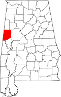 | |
| Towns | ||
| CDP | ||
| Unincorporated communities | ||
This article is issued from Wikipedia - version of the 7/31/2016. The text is available under the Creative Commons Attribution/Share Alike but additional terms may apply for the media files.