Coal Fire, Alabama
"Coal fire" redirects here. For an underground coal fire, see Coal seam fire.
| Coal Fire, Alabama | |
|---|---|
| Unincorporated community | |
 Coal Fire, Alabama Location within the state of Alabama | |
| Coordinates: 33°08′28″N 88°02′19″W / 33.1412335°N 88.0386336°WCoordinates: 33°08′28″N 88°02′19″W / 33.1412335°N 88.0386336°W | |
| Country | United States |
| State | Alabama |
| County | Pickens |
| Elevation | 282 ft (86 m) |
| Time zone | Central (CST) (UTC-6) |
| • Summer (DST) | CDT (UTC-5) |
| Area code(s) | 205 |
Coal Fire, also known as Cold Fire, Coalfire, and Fundee, is an unincorporated community in Pickens County, Alabama, United States.[1]
History
The community was first known as Fundee, which was a portmanteau of two local family names, the Funderburks and the DeLoaches. It was then renamed for a local creek, which has been recorded as both Coal Fire and Cold Fire.[2] A post office called Coal Fire was established in 1871, and remained in operation until being discontinued in 1927.[3]
References
- ↑ U.S. Geological Survey Geographic Names Information System: Coal Fire, Alabama
- ↑ Foscue, Virginia (1989). Place Names in Alabama. Tuscaloosa: The University of Alabama Press. p. 38. ISBN 0-8173-0410-X.
- ↑ "Pickens County". Jim Forte Postal History. Retrieved 7 October 2014.
Municipalities and communities of Pickens County, Alabama, United States | ||
|---|---|---|
| Cities | 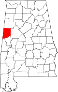 | |
| Towns | ||
| CDP | ||
| Unincorporated communities | ||
This article is issued from Wikipedia - version of the 6/11/2016. The text is available under the Creative Commons Attribution/Share Alike but additional terms may apply for the media files.