List of Scheduled Monuments in Monmouthshire
Monmouthshire has 200 Scheduled monuments. The 46 prehistoric scheduled sites include burial sites, enclosures and 16 hill forts. Ten sites date from the Roman period, including four villas. There are four early Christian sites from early medieval times. The 101 sites from the medieval post-Norman period include spectacular castles and hidden castle mounds, remote dwellings, grand abbeys, holy wells, stones and churches. Finally the modern period has a 39 sites, including a very wide range of early industrial activities.
Scheduled Ancient Monuments (SAMs) have statutory protection. The compilation of the list is undertaken by Cadw Welsh Historic Monuments, which is an executive agency of the National Assembly of Wales.[1] The list of scheduled monuments below is supplied by Cadw[2] with additional material from RCAHMW and Glamorgan-Gwent Archaeological Trust.
Scheduled Monuments in Monmouthshire
| Image | Name | Site type | Community | Location | Details | Historic County | Period[lower-alpha 1] | SAM No & Refs |
|---|---|---|---|---|---|---|---|---|
 |
Gray Hill Stone Circle | Stone circle | Caerwent | 51°38′16″N 2°48′49″W / 51.6379°N 2.8136°W, ST437935 |
Fourteen visible stones, nine of which lie on their sides end to end, forming a circle. Possibly curb stones for a burial mound, or a stone circle. | Monmouthshire | Bronze Age | MM031 |
 |
Thornwell Farm burial mounds | Chambered long barrow | Chepstow | 51°37′17″N 2°40′02″W / 51.6213°N 2.6673°W, ST539916 |
Two burial mounds now within a Chepstow housing estate. One may be a Neolithic long barrow, with stone chambers. The other is a Bronze Age round barrow. | Monmouthshire | Neolithic | MM206 |
| St Peter's Cave | Cave | Chepstow | 51°37′53″N 2°40′04″W / 51.6313°N 2.6677°W, ST538927 |
A very wet cave under the cliffs of the Chepstow Bulwarks | Monmouthshire | Prehistoric | MM160 | |
| Llangibby Bottom Standing Stone | Standing stone | Llangybi | 51°39′46″N 2°53′50″W / 51.6628°N 2.8971°W, ST380963 |
The 1.7m high stone is in 'Priest's Meadow', and is claimed to be the spot where St Cybi pitched his tent when arriving in the 6th century. Also known as Waen-y-'Ffeirad. | Monmouthshire | Bronze Age | MM106 | |
 |
Heston Brake Long Barrow | Long barrow | Portskewett | 51°35′41″N 2°42′55″W / 51.5946°N 2.7154°W, ST505886 |
Evidence of a significant neolithic chambered tomb or long barrow. A small group of puddingstones mark the entrance of the site. Human skeletons, cattle bones and some pottery were discovered in the chamber when it was excavated in 1888. | Monmouthshire | Neolithic | MM018 |
 |
Llanfihangel Rogiet Standing Stone | Standing stone | Rogiet | 51°35′10″N 2°48′08″W / 51.586°N 2.8022°W, ST445877 |
A triangular tapered standing stone, 2.4m high, and 1.6m by 0.5m at the base. Also known as The Devil's Quoit.[8]:152 | Monmouthshire | Bronze Age? | MM068 |
 |
Gaerllwyd Burial Chamber | Chambered tomb | Shirenewton | 51°40′00″N 2°48′00″W / 51.6667°N 2.8°W, ST447967 |
A portal dolmen with eleven conglomerate stones, some standing and some upright, supporting a large capstone. | Monmouthshire | Neolithic | MM013 |
 |
Harold's Stones | Stone alignment | Trellech United | 51°44′34″N 2°43′36″W / 51.7427°N 2.7266°W, SO499051 |
Three large monoliths, made of pudding stone, aligned from northeast by east to southwest by west. Local legends say that the stones were thrown by Jack o' Kent from the summit of the Skirrid, over twelve miles away.[11]:45 | Monmouthshire | Bronze Age | MM017 |
| Crick Round Barrow | Round barrow | Caerwent | 51°36′32″N 2°44′45″W / 51.6088°N 2.7459°W, ST484902 |
A round barrow (41m in diameter and 1.5m high). Excavations in 1939 and 1979 found Bronze Age flint tools, funerary remains, and a stone kerb ring 29m in diameter. Some of the cup stones may have been used for astronomical observations.[13] | Monmouthshire | Bronze Age | MM151 | |
| Foresters' Oaks round barrow | Round barrow | Caerwent | 51°38′34″N 2°49′31″W / 51.6428°N 2.8254°W, ST429941 |
A Bronze Age barrow approximately 16m in diameter and 1m high. | Monmouthshire | Bronze Age? | MM333 | |
| Five Lanes Round Barrow | Round barrow | Caerwent | 51°36′52″N 2°47′41″W / 51.6144°N 2.7946°W, ST450909 |
One of a pair of Bronze Age barrows (the other is not scheduled). The barrow is 35m in diameter but was probably smaller (25m). | Monmouthshire | Bronze Age | MM179 | |
| Cwm Bwchel Round Cairn | Round cairn | Llanvihangel Crucorney | 51°56′20″N 3°03′17″W / 51.9388°N 3.0548°W, SO275272 |
Monmouthshire | Prehistoric | MM343 | ||
| Garreg Las Round Cairns | Round cairn | Llanvihangel Crucorney | 51°55′30″N 3°00′23″W / 51.9249°N 3.0063°W, SO309256 |
Monmouthshire | Prehistoric | MM302 | ||
| Graig Ddu Round Cairn | Round cairn | Llanvihangel Crucorney | 51°56′19″N 3°03′17″W / 51.9387°N 3.0548°W, SO284264 |
Monmouthshire | Prehistoric | MM342 | ||
| Hatterrall Hill Enclosure | Enclosure | Llanvihangel Crucorney | 51°55′27″N 3°00′30″W / 51.9241°N 3.0083°W, SO308255 |
Monmouthshire | Prehistoric | MM261 | ||
 |
Loxidge Tump cairn | Round cairn | Llanvihangel Crucorney | 51°57′25″N 3°02′11″W / 51.9569°N 3.0363°W, SO288292 |
Monmouthshire | Prehistoric | MM304 | |
| Rhiw Arw cairn | Round cairn | Llanvihangel Crucorney | 51°56′18″N 3°00′32″W / 51.9383°N 3.0089°W, SO307271 |
Monmouthshire | Prehistoric | MM299 | ||
| Three Wells Round Cairn | Round cairn | Llanvihangel Crucorney | 51°54′29″N 2°59′47″W / 51.908°N 2.9964°W, SH315237 |
Monmouthshire | Prehistoric | MM303 | ||
| Chepstow Park Wood Cairn | Round cairn | Devauden | 51°40′28″N 2°44′15″W / 51.6744°N 2.7376°W, ST490975 |
Monmouthshire | Prehistoric | MM286 | ||
 |
Carn Blorenge | Round cairn | Llanfoist Fawr | 51°48′02″N 3°03′37″W / 51.8006°N 3.0602°W, SO269118 |
Monmouthshire | Bronze Age | MM219 | |
 |
Carn-y-Defaid Round Cairns | Round cairn | Llanfoist Fawr, (also Blaenavon), (see also Torfaen) | 51°47′03″N 3°03′31″W / 51.7842°N 3.0585°W, SO270100 |
Monmouthshire | Prehistoric | MM209 | |
 |
Middle Hendre Round Barrow | Round barrow | Llangattock-Vibon-Avel | 51°49′12″N 2°47′37″W / 51.82°N 2.7936°W, SO453137 |
Monmouthshire | Prehistoric | MM112 | |
| Round Barrow 180m North of Ty-Canol | Round barrow | Llanover | 51°46′01″N 2°56′30″W / 51.767°N 2.9417°W, SO351080 |
Monmouthshire | Prehistoric | MM081 | ||
| Wentwood Lodge Round Barrows | Round barrow | Shirenewton | 51°38′48″N 2°50′41″W / 51.6467°N 2.8446°W, ST416945 |
Two round barrows 180m north-west of Wentwood Lodge. | Monmouthshire | Prehistoric | MM167 | |
| Lower Hale Wood Round Barrows | Round cairn | Tintern | 51°42′20″N 2°41′42″W / 51.7055°N 2.6951°W, SO520009 |
Three Round Barrows in Lower Hale Wood. | Monmouthshire | Prehistoric | MM191 | |
| Gwehelog Camp | Enclosure | Gwehelog Fawr | 51°43′04″N 2°52′27″W / 51.7177°N 2.8743°W, SO397024 |
Also known as Gwernydd camp. 650m South of Ty Freeman. | Monmouthshire | Prehistoric | MM178 | |
| Defended Enclosure 350m NNW of Ty-Uchaf | Enclosure - Defensive | Llanelly | 51°49′51″N 3°07′34″W / 51.8309°N 3.1262°W, SO224153 |
Brecknockshire | Prehistoric | BR405 | ||
| Buckholt Wood Hilltop Enclosure | Enclosure | Monmouth | 51°50′23″N 2°43′27″W / 51.8397°N 2.7241°W, SO502159 |
Monmouthshire | Prehistoric | MM258 | ||
 |
Sudbrook Camp and Sudbrook Chapel | Enclosure | Portskewett | 51°34′57″N 2°42′55″W / 51.5826°N 2.7154°W, ST505873 |
Monmouthshire | Prehistoric | MM048 | |
| Bishop Barnet's Wood Camp | Enclosure | Mathern | 51°38′40″N 2°41′45″W / 51.6445°N 2.6957°W, ST519941 |
Monmouthshire | Prehistoric | MM139 | ||
 |
Llanmelin Wood Hill Fort |
Hill fort | Shirenewton | 51°37′45″N 2°46′46″W / 51.6291°N 2.7794°W, ST461925 |
A roughly oval hilltop fort (140m by 100m), with an area of about 6.56 hectares.[36] Originally univallate, but expansion in the 2nd century BC added further banks. Archaelogical investigations have indicated occupation during Roman times and in the 12th and 13th centuries. | Monmouthshire | Iron Age | MM024 |
| The Larches Camp | Hill fort | Caerwent | 51°36′21″N 2°49′13″W / 51.6058°N 2.8202°W, ST432899 |
A roughly D-shaped hill top fort (140m by 100m), with an area of about 1.24 hectares.[36] The north is protected by a steep slope, with a bank and ditch around the rest of the site. | Monmouthshire | Iron Age | MM069 | |
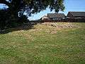
| Chepstow Bulwarks Camp |
Hill fort | Chepstow | 51°37′52″N 2°40′08″W / 51.6312°N 2.6689°W, ST538927 |
A small defensive hill fort, on top of cliffs overlooking the River Wye, the Beachley peninsula and the Severn estuary. It was probably built around the first century BC or the first century AD. | Monmouthshire | Iron Age | MM093 | |
 |
Pen-Twyn Earthwork | Hill fort | Llanvihangel Crucorney | 51°54′04″N 2°59′15″W / 51.9011°N 2.9874°W, SO321229 |
A roughly rectangular hill top fort (140m by 70m), with an area of about 4.17 hectares.[36] The fort is at the south end of Hatterall Hill with the ground sloping away to the east, south and west. The site is divided by a West-East bank and ditch. This may indicate the northern part is the oldest and extended later to include the southern part. Offa's Dyke Path passes through the site. | Monmouthshire | Iron Age | MM064 |
 |
Twyn-y-Gaer Camp | Hill fort | Llanvihangel Crucorney | 51°53′30″N 3°01′38″W / 51.8916°N 3.0273°W, SO294219 |
An elongated oval summit hill fort (roughly 225m by 85m), with an area of about 2.97 hectares.[36] The fort occupies the top of Gaer hill and is split into three enclosures. Excavations in the 1960s and 1970s discovered jewelry, tools, ovens, signs of metal working, and traces of timber housing. | Monmouthshire | Iron Age | MM148 |
 |
Llancayo Camp | Hill fort | Gwehelog Fawr | 51°43′46″N 2°54′07″W / 51.7294°N 2.902°W, SO378038 |
An oval univallate hill fort, of roughly 2.00 hectares[36] at the northern edge of a ridge. The fort includes a complex entrance, possibly a causeway, at the south-east of the site. | Monmouthshire | Iron Age | MM078 |
 |
Coed y Bwnydd Camp | Hill fort | Llanarth | 51°45′23″N 2°55′13″W / 51.7565°N 2.9203°W, SO365068 |
A large multivallate fort at the southern tip of Clytha Hill. The oval fort measures about 170m by 114m with an area of 6.39 hectares.[36] | Monmouthshire | Iron Age | MM075 |
| Gaer Fawr hill fort | Hill fort | Llangwm | 51°41′07″N 2°48′35″W / 51.6853°N 2.8096°W, ST441988 |
A roughly oval multivallate hill fort on a spur with an area of 3.50 hectares.[36] The hill fort is surrounded by steep slopes to the west, north, and east. The site is broken up by lanes and field boundaries. | Monmouthshire | Iron Age | MM062 | |
| Great House Camp | Hill fort | Llangwm | 51°43′34″N 2°49′23″W / 51.7261°N 2.8231°W, SO432033 |
A roughly circular multivallate hill fort sited on a natural terrace. The internal dimensions are 140m by 150m with an area of 2.37 hectares.[36] | Monmouthshire | Iron Age? | MM105 | |
 |
Cae Camp | Hill fort | Llanhennock | 51°38′23″N 2°55′40″W / 51.6398°N 2.9278°W, ST358938 |
An oval bivallate fort situated on a ridge, roughly 92m by 86m with an area of 1.59 hectares.[36] The sites contains a disused quarry from much later times. | Monmouthshire | Iron Age | MM079 |
| Candwr Camp | Hill fort | Llanhennock | 51°38′09″N 2°58′11″W / 51.6357°N 2.9698°W, ST329934 |
Also known as Caerau Hill fort. The univallate fort is roughly circular (100m by 75m), sited on a natural prominence, with an area of 0.70 hectares.[36] | Monmouthshire | Iron Age | MM135 | |
 |
Wilcrick Hill Camp | Hill fort | Magor with Undy, (also Bishton), (see also Newport) | 51°35′09″N 2°51′04″W / 51.5859°N 2.8512°W, ST411877 |
A large, roughly oval (194m by 134m) multivallate hill fort with an area of 1.0 hectares.[36] The fort is surrounded on all sides by steep slopes. | Monmouthshire | Iron Age | MM127 |
| Gaer Hill Camp, Penterry | Hill fort | St Arvans | 51°40′40″N 2°42′01″W / 51.6779°N 2.7002°W, ST516979 |
A hilltop fort with commanding views. The fort includes roughly rectangular inner area (46m x 68m), inside a larger, roughly circular enclosure (240m x 254m). | Monmouthshire | Iron Age | MM025 | |
%2C_Piercefield%2C_St_Arvans.jpg) |
Pierce Wood Camps | Hill fort | St Arvans | 51°39′37″N 2°40′20″W / 51.6604°N 2.6721°W, ST536959 |
Two hill forts on a steeply sided promontory of the River Wye, to the east of Piercefield House.
The smaller (westerly) univallate fort is roughly rectangular (98m x 82m), with an area of 0.20 hectares.[36] The Wye Valley Walk passes through the site. The larger (easterly) univallate fort is also roughly rectangular (388m x 110m). |
Monmouthshire | Iron Age | MM020 |
 |
Blackcliff Wood Camp | Hill fort | Tintern | 51°41′16″N 2°40′58″W / 51.6878°N 2.6827°W, ST529990 |
A roughly oval fort (72m x 46m) with an area of 0.46 hectares.[36] The Wye Valley Walk passes through the site. Also known as Porthcaseg Fort. | Monmouthshire | Iron Age | MM027 |
| Gaer hill fort, Trellech | Hill fort | Trellech United | 51°43′49″N 2°44′08″W / 51.7303°N 2.7356°W, SO492037 |
A roughly circular (diameter 33m) bivallate fort with an area of 3.50 hectares.[36] | Monmouthshire | Iron Age | MM077 | |
| Abergavenny Roman Fort | Fort | Abergavenny | 51°49′13″N 3°01′08″W / 51.8204°N 3.019°W, SO298140 |
Monmouthshire | Roman | MM193 | ||
 |
Caerwent Roman Town (Venta Silurum) |
House (domestic) | Caerwent | 51°36′45″N 2°46′06″W / 51.6126°N 2.7683°W, ST469907 |
Extensively excavated Roman town. Much of the excavated remains are now open to the public. | Monmouthshire | Roman | MM001 |
| Church Farm Romano-British settlement | Enclosure | Caldicot | 51°35′57″N 2°44′59″W / 51.5993°N 2.7496°W, ST481892 |
Monmouthshire | Late Iron Age/Roman | MM334 | ||
| Stoop Hill Cropmark Enclosure | Enclosure | Caldicot | 51°34′58″N 2°44′50″W / 51.5828°N 2.7472°W, ST483873 |
Enclosure revealed by Aerial Photography. | Monmouthshire | Roman | MM169 | |
| Portskewett Hill Roman Site | Unclassified site | Portskewett | 51°35′41″N 2°43′35″W / 51.5946°N 2.7264°W, ST497886 |
Monmouthshire | Roman | MM019 | ||
| Usk Roman Site | Fort | Usk | 51°42′05″N 2°53′58″W / 51.7014°N 2.8995°W, SO379006 |
The Roman legionary fortress of Burrium was founded on the site of Usk by the military commander Aulus Didius Gallus, around AD 55 | Monmouthshire | Roman | MM155 | |
| Five Lanes Roman Site | Villa | Caerwent | 51°36′55″N 2°48′04″W / 51.6153°N 2.8011°W, ST446910 |
Remains of a Roman villa comprising a winged corridor with five rooms and other structures. Near to the Roman town at Caerwent. | Monmouthshire | Roman | MM350 | |
| Whitewall Brake Roman Site | Villa | Caerwent | 51°37′00″N 2°45′33″W / 51.6168°N 2.7592°W, ST475911 |
Rectilinear complex of building ranges and courts, where a Roman mosaic, along with characteristic Roman building debris was discovered | Monmouthshire | Roman | MM152 | |
| Little Hadnock Roman Villa, Dixton Newtown | Villa | Monmouth | 51°50′02″N 2°40′33″W / 51.8338°N 2.6758°W, SO535152 |
Group of stone buildings, one with hypocaust. Finds indicate occupation in the 2nd-3rd century AD. | Monmouthshire | Roman | MM195 | |
| Wyndcliff Roman Site | Villa | St Arvans | 51°40′30″N 2°41′04″W / 51.6751°N 2.6844°W, ST527975 |
Monmouthshire | Roman | MM351 | ||
| Hatterrall Hill Cross Ridge Dyke | Linear earthwork | Llanvihangel Crucorney | 51°55′13″N 3°00′52″W / 51.9202°N 3.0144°W, SO303251 |
Monmouthshire | Early Medieval | MM260 | ||
_from_White_Castle_-_geograph_-_3061246.jpg) |
Skirrid Fawr hill fort | Hill fort | Llantilio Pertholey | 51°51′28″N 2°58′23″W / 51.8579°N 2.9731°W, SO330181 |
An elongated roughly oval multivallate hill fort at the northern end of a mountain ridge. The area of the hill fort includes the foundations of St Michael's Chapel. | Monmouthshire | Iron Age | MM182 |
 |
St Michaels Chapel (remains) | Chapel | Llantilio Pertholey | 51°51′28″N 2°58′23″W / 51.8579°N 2.9731°W, SO330181 |
The foundations of a medieval chapel (4m north-south by 7.5m east-west) at the northern end of a mountain ridge. The chapel lies within the area of the Skirrid Fawr hill fort. | Monmouthshire | Early Medieval | MM182 |
 |
Croes Lwyd Farm Cross | Cross | Raglan | 51°45′30″N 2°52′12″W / 51.7584°N 2.8699°W, SO400069 |
An octagonal cross shaft and head carved from a single block. Marked on a 14th-century map. | Monmouthshire | Early Medieval | MM156 |
| St Arvan's Church Cross-slab | Cross-marked stone | St Arvans | 51°39′55″N 2°42′01″W / 51.6653°N 2.7004°W, ST516965 |
Monmouthshire | Early Medieval | MM355 | ||
 |
Abergavenny Bridge | Bridge | Abergavenny | 51°49′10″N 3°01′45″W / 51.8195°N 3.0292°W, SO291139 |
(also known as Tudor Bridge) | Monmouthshire | 15th & 19th Century | MM010 |
 |
Abergavenny Castle | Castle | Abergavenny | 51°49′11″N 3°01′03″W / 51.8197°N 3.0174°W, SO299139 |
Fortified site since prehistoric times. 11th century Norman motte, with major building during 13th and 14th centuries. The keep was rebuilt in the 19th century and now houses a museum. | Monmouthshire | Medieval | MM056 |
| St Mary's Priory | Priory | Abergavenny | 51°49′17″N 3°00′57″W / 51.8213°N 3.0157°W, SO300141 |
Area of Conventual Buildings. | Monmouthshire | Medieval | MM183 | |
| Crick Medieval House | House (domestic) | Caerwent | 51°36′32″N 2°44′15″W / 51.6089°N 2.7376°W, ST490902 |
Monmouthshire | Medieval | MM053 | ||
| Crick Moated Site | Moated Site | Caerwent | 51°36′34″N 2°44′16″W / 51.6095°N 2.7378°W, ST490903 |
Monmouthshire | Medieval | MM051 | ||
 |
Dinham Castle | Castle | Caerwent | 51°37′39″N 2°45′08″W / 51.6274°N 2.7522°W, ST480923 |
Slight and overgrown remains of a small castle.[72]:66 One of six castles around Wentwood Forest.[lower-alpha 2] | Monmouthshire | Medieval | MM153 |
 |
Llanvair Castle | Castle | Caerwent | 51°37′40″N 2°48′07″W / 51.6278°N 2.802°W, ST445924 |
Remains of a small courtyard castle.[72]:29 One of six castles around Wentwood Forest.[lower-alpha 2] | Monmouthshire | Medieval | MM047 |
 |
St. Brides Netherwent Deserted Village | Deserted Medieval Village | Caerwent | 51°36′06″N 2°49′39″W / 51.6017°N 2.8276°W, ST427895 |
By tradition founded by Brochwael, the son of Meurig of Gwent, in the 10th century | Monmouthshire | Medieval | MM154 |
 |
Caldicot Castle (unoccupied parts) | Castle | Caldicot | 51°35′36″N 2°44′36″W / 51.5932°N 2.7432°W, ST486885 |
An extensive stone medieval castle (probably built on the site of an older earthwork castle) dated from the 13th and 14th century with some changes in the 15th century, and substantially restored and rebuilt in the 19th century.[72]:15–18 | Monmouthshire | Medieval | MM050 |
| The Berries Mound & Bailey Castle | Motte & Bailey | Caldicot | 51°36′08″N 2°44′29″W / 51.6022°N 2.7415°W, ST487895 |
Also known as Ballan Moor and Mount Ballan. A small motte with a large D-shaped bailey, in a low-lying, marshy area.[78]:255 Probably built by the Ballon family in the late 11th century or early 12th century.[72]:55 | Monmouthshire | Medieval | MM026 | |
 |
Chepstow Castle |
Castle | Chepstow | 51°38′37″N 2°40′32″W / 51.6437°N 2.6755°W, ST533940 |
The castle is the most southerly of the Welsh Marches castles, overlooking the River Wye. Constructed in the late 11th century with 12th- and 13th-century additions. | Monmouthshire | Medieval | MM003 |
 |
Chepstow Port Wall |
Town defences | Chepstow | 51°38′25″N 2°40′34″W / 51.6404°N 2.6762°W, ST533937 |
Monmouthshire | Medieval | MM002 | |
| St Martin's Cwmyoy, Churchyard Cross | Cross | Llanvihangel Crucorney | 51°54′15″N 3°01′13″W / 51.9042°N 3.0202°W, SO299233 |
Monmouthshire | Medieval | MM142 | ||
 |
Llanthony Priory |
Priory | Llanvihangel Crucorney | 51°56′41″N 3°02′11″W / 51.9448°N 3.0364°W, SO289278 |
Monmouthshire | Medieval | MM004 | |
| Pen-y-Clawdd Castle Mound | Motte | Llanvihangel Crucorney | 51°52′31″N 3°00′13″W / 51.8752°N 3.0037°W, SO310201 |
A low circular ditched mound. | Monmouthshire | Medieval | MM145 | |
| Penbidwal Moated Site | Moated Site | Llanvihangel Crucorney | 51°53′39″N 2°57′30″W / 51.8942°N 2.9582°W, SO341221 |
Monmouthshire | Medieval | MM210 | ||
 |
Tre Fedw, Moat Mound and Bailey Castle | Motte & Bailey | Llanvihangel Crucorney | 51°53′26″N 2°58′27″W / 51.8905°N 2.9743°W, SO330217 |
Monmouthshire | Medieval | MM063 | |
| Chepstow Park Wood Moated Site | Moated Site | Devauden | 51°40′42″N 2°44′20″W / 51.6783°N 2.7388°W, ST490979 |
Monmouthshire | Medieval | MM103 | ||
| Cwrt y Gaer Ringwork | Ringwork | Devauden | 51°41′42″N 2°47′56″W / 51.6949°N 2.799°W, ST448998 |
Monmouthshire | Medieval | MM067 | ||
 |
Holy Cross Kilgwrrwg, Churchyard Cross | Cross | Devauden | 51°40′56″N 2°46′45″W / 51.6822°N 2.7792°W, ST462984 |
Monmouthshire | Medieval | MM104 | |
 |
St Thomas a Becket's Wolvesnewton, Churchyard Cross | Cross | Devauden | 51°41′38″N 2°47′27″W / 51.6939°N 2.7909°W, ST454997 |
Monmouthshire | Medieval | MM330 | |
| Goytre Wood Castle Mound | Motte | Grosmont | 51°54′16″N 2°56′29″W / 51.9045°N 2.9415°W, SO353233 |
Also known as Gwern Castle. A small damaged motte, 20m in diameter and 4m high. Remnants of a rectangular stone building on summit.[78]:200 | Monmouthshire | Medieval | MM138 | |
 |
Grosmont Castle |
Castle | Grosmont | 51°54′55″N 2°51′57″W / 51.9154°N 2.8657°W, SO405244 |
The present ruins date from three building phases in the 11th and 12th centuries. One of 'The Three Castles'[lower-alpha 3] in the Monnow valley. | Monmouthshire | Medieval | MM007 |
| St Nicholas' Grosmont, Churchyard Cross | Cross | Grosmont | 51°54′51″N 2°52′01″W / 51.9143°N 2.8669°W, SO404243 |
Monmouthshire | Medieval | MM147 | ||
 |
St Cadoc's Llangattock Lingoed, Churchyard Cross | Cross | Grosmont | 51°52′31″N 2°55′43″W / 51.8754°N 2.9287°W, SO361200 |
Monmouthshire | Medieval | MM319 | |
| St James's Llanvetherine, Churchyard Cross | Cross | Grosmont | 51°50′59″N 2°55′28″W / 51.8497°N 2.9244°W, SO364171 |
Monmouthshire | Medieval | MM317 | ||
 |
St David's Trostre, Churchyard Cross | Cross | Gwehelog Fawr | 51°44′05″N 2°55′43″W / 51.7347°N 2.9285°W, SO359044 |
Monmouthshire | Medieval | MM321 | |
 |
St Aeddan's Bettws Newydd, Churchyard Cross | Cross | Llanarth | 51°44′52″N 2°55′30″W / 51.7478°N 2.9251°W, SO362058 |
Monmouthshire | Medieval | MM122 | |
| St Teilo's Llanarth, Churchyard Cross | Cross | Llanarth | 51°47′37″N 2°54′24″W / 51.7937°N 2.9066°W, SO375109 |
Monmouthshire | Medieval | MM116 | ||
 |
St Mabli's Llanvapley, Churchyard Cross | Cross | Llanarth | 51°49′18″N 2°55′12″W / 51.8217°N 2.9201°W, SO366140 |
Monmouthshire | Medieval | MM318 | |
| St Peter's Bryngwyn, Churchyard Cross | Cross | Llanarth | 51°46′45″N 2°53′05″W / 51.7792°N 2.8847°W, SO390093 |
Monmouthshire | Medieval | MM323 | ||
| Twyn y Cregen Castle Mound | Motte | Llanarth | 51°46′55″N 2°55′31″W / 51.782°N 2.9252°W, SO362096 |
A 5m high mound 20m in diameter, and no traces of a ditch. | Monmouthshire | Medieval | MM080 | |
| Wern-y-Cwrt Castle Mound | Motte | Llanarth | 51°46′29″N 2°52′47″W / 51.7746°N 2.8797°W, SO394088 |
A steep-sided mound (26m in diameter and 4.5m high) with traces of a surrounding ditch. | Monmouthshire | Medieval | MM099 | |
| Graig Foel medieval ringwork | Ringwork | Llanbadoc | 51°42′17″N 2°54′49″W / 51.7046°N 2.9136°W, SO369010 |
Monmouthshire | Medieval | MM335 | ||
| Battle Tump | Mound | Llanelly | 51°50′03″N 3°05′39″W / 51.8341°N 3.0941°W, SO247156 |
Brecknockshire | Medieval | BR010 | ||
 |
St Peter's Llanwenarth, Churchyard Cross | Cross | Llanfoist Fawr | 51°49′38″N 3°03′09″W / 51.8271°N 3.0524°W, SO275147 |
Monmouthshire | Medieval | MM118 | |
 |
St Faith's Llanfoist, Churchyard Cross | Cross | Llanfoist Fawr | 51°48′46″N 3°02′11″W / 51.8129°N 3.0365°W, SO288132 |
Monmouthshire | Medieval | MM306 | |
| Skenfrith Deserted Medieval Settlement | Deserted Medieval Village | Llangattock-Vibon-Avel | 51°52′43″N 2°47′39″W / 51.8785°N 2.7942°W, SO454202 |
Monmouthshire | Medieval | MM215 | ||
| Newcastle Castle | Motte & Bailey | Llangattock-Vibon-Avel | 51°51′05″N 2°48′14″W / 51.8513°N 2.8038°W, SO447172 |
Monmouthshire | Medieval | MM085 | ||
 |
Grace Dieu Abbey | Abbey | Llangattock-Vibon-Avel | 51°48′51″N 2°47′51″W / 51.8142°N 2.7974°W, SO451131 |
Monmouthshire | Medieval | MM158 | |
 |
Skenfrith Castle |
Castle | Llangattock-Vibon-Avel | 51°52′43″N 2°47′25″W / 51.8786°N 2.7904°W, SO456203 |
One of three castles brought under a single lordship in 1138, the present ruins date from the 12th century.[72]
:46–47 One of 'The Three Castles'[lower-alpha 3] in the Monnow valley. |
Monmouthshire | Medieval | MM088 |
| Llangwm Mound & Bailey Castle | Motte | Llangwm | 51°41′38″N 2°49′47″W / 51.694°N 2.8297°W, ST427997 |
A low oval (14m-16m) motte. | Monmouthshire | Medieval | MM061 | |
| Rockfield Farm motte | Ringwork | Llangwm | 51°42′21″N 2°50′04″W / 51.7057°N 2.8345°W, SO424011 |
Ringwork north-east of New House. | Monmouthshire | Medieval | MM074 | |
 |
Ffynnon Cybi (St Cybi's Well) | Well | Llangybi | 51°39′55″N 2°54′21″W / 51.6652°N 2.9058°W, ST374966 |
Monmouthshire | Medieval | MM074 | |
 |
Llangibby Castle (Castell Tregrug) | Castle | Llangybi | 51°40′18″N 2°55′16″W / 51.6717°N 2.9211°W, ST364973 |
A roughly rectangular castle sited on the summit of a ridge. Probably built in the early 14th century. The castle is largely ruinous but parts of walls and towers remain. Replaced an earlier motte and bailey (Llangibby Castle Mound) 400m to the east. | Monmouthshire | Medieval | MM109 |
 |
Llangibby Castle Mound | Motte | Llangybi | 51°40′17″N 2°54′47″W / 51.6714°N 2.913°W, ST369973 |
Also known as Bowling Green. A large low flat-topped circular mound. The site was heavily landscaped in the 18th century. Generally supposed to pre-date the nearby Llangibby Castle, but may post-date the castle.[78]:237 | Monmouthshire | Medieval | MM110 |
 |
Castell Arnallt (Castle Arnold) | Motte | Llanover | 51°47′06″N 2°59′14″W / 51.7849°N 2.9873°W, SO319100 |
A fortified court house, or llys, of Seisyll ap Dyfnwal, lord of Over Gwent (Gwent Uwchcoed), before it was destroyed after Seisyll and some of his household were killed in 1175. Minor earthwork remains. | Monmouthshire | Medieval | MM086 |
 |
St Cadoc's Llangattock Nigh Usk, Churchyard Cross | Cross | Llanover | 51°46′54″N 2°58′20″W / 51.7816°N 2.9722°W, SO330096 |
Parish is also known as Llangattock Juxta Usk. | Monmouthshire | Medieval | MM123 |
 |
St David's Llanddewi Rhydderch, Churchyard Cross | Cross | Llanover | 51°48′41″N 2°56′40″W / 51.8114°N 2.9444°W, SO349129 |
Monmouthshire | Medieval | MM117 | |
 |
St Michael's Llanvihangel Nigh Usk, Churchyard Cross | Cross | Llanover | 51°46′40″N 2°56′57″W / 51.7778°N 2.9491°W, SO346092 |
(also known as Llanfihangel Gobion) | Monmouthshire | Medieval | MM124 |
 |
St Mary's Yard Castle Mound | Motte | Llanover | 51°45′26″N 2°56′36″W / 51.7573°N 2.9434°W, SO349069 |
A low D-shaped mound near the village of Llanfair Kilgeddin. | Monmouthshire | Medieval | MM082 |
 |
St Bartholomew's Llanover, Churchyard Cross | Cross | Llanover | 51°46′45″N 2°59′24″W / 51.7791°N 2.9901°W, SO317094 |
Monmouthshire | Medieval | MM307 | |
 |
St Bridget's Llansantffraed, Churchyard Cross | Cross | Llanover | 51°47′06″N 2°55′59″W / 51.7849°N 2.9331°W, SO357099 |
Monmouthshire | Medieval | MM312 | |
 |
St Mary's Llanfair Cilgedyn, Churchyard Cross | Cross | Llanover | 51°46′22″N 2°56′06″W / 51.7729°N 2.9351°W, SO355086 |
Monmouthshire | Medieval | MM326 | |
.jpg) |
Hen Gwrt Moated Site |
Moated Site | Llantilio Crossenny | 51°49′53″N 2°52′42″W / 51.8315°N 2.8782°W, SO395151 |
Monmouthshire | Medieval | MM094 | |
 |
Penrhos Mound & Bailey Castle | Motte & Bailey | Llantilio Crossenny | 51°48′53″N 2°51′29″W / 51.8146°N 2.8581°W, SO409132 |
A ditched motte, about 30m in diameter and 6.0m high, standing towards the south of an irregular oval enclosure defined by a ditch. It is possibly the castle mentioned as being demolished c.1252. | Monmouthshire | Medieval | MM097 |
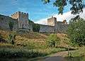
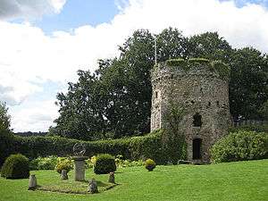
 |
White Castle |
Castle | Llantilio Crossenny | 51°50′46″N 2°54′08″W / 51.8461°N 2.9022°W, SO379167 |
Norman in origins, it was first known as Llantilio Castle, but called the White Castle (after its whitewashed walls) from the 13th century. One of 'The Three Castles'[lower-alpha 3] in the Monnow valley. | Monmouthshire | Medieval | MM006 |
| Coed-Cwnwr Moated Site | Moated Site | Llantrisant Fawr | 51°41′26″N 2°51′04″W / 51.6905°N 2.8511°W, ST412994 |
An earthwork comprising a ditch enclosing a roughly 30m square area | Monmouthshire | Medieval | MM060 | |
| Moated Site North West of Bertholey House (White Hall) | Moated Site | Llantrisant Fawr | 51°38′57″N 2°53′02″W / 51.6493°N 2.8839°W, ST389948 |
Monmouthshire | Medieval | MM040 | ||
 |
Medieval Building adjoining Magor Churchyard | House (domestic) | Magor with Undy | 51°34′44″N 2°49′53″W / 51.579°N 2.8314°W, ST424870 |
Procurator's House | Monmouthshire | Medieval | MM180 |
| Medieval Moated Site 400m N of Undy Church | Moated Site | Magor with Undy | 51°34′56″N 2°48′36″W / 51.5823°N 2.81°W, ST439873 |
Courtfield is a domestic site comprising a central 'platform' measuring 60m (NE-SW) by 45m, embanked on the NE, surrounded by a ditch up to 1.2m deep and an outer bank 0.5m high; traces of bank and ditch projecting NW from the N corner are still visible. | Monmouthshire | Medieval | MM198 | |
| Relict Seawall alongside Collister Pill Reen | Seawall | Magor with Undy | 51°34′33″N 2°48′04″W / 51.5759°N 2.801°W, ST445866 |
1.3 km stretch of embankment on the western side of Collister Pill Reen: thought to be an early feature in the landscape of the Caldicot levels | Monmouthshire | Medieval | MM226 | |
| St Mary's Magor, Churchyard Cross | Cross | Magor with Undy | 51°34′45″N 2°49′50″W / 51.5793°N 2.8306°W, ST425870 |
Monmouthshire | Medieval | MM314 | ||
| St Mary's Undy, Churchyard Cross | Cross | Magor with Undy | 51°34′42″N 2°48′35″W / 51.5782°N 2.8096°W, ST439869 |
Monmouthshire | Medieval | MM126 | ||
| Moated Site South of Moynes Court | Moated Site | Mathern | 51°36′52″N 2°41′41″W / 51.6144°N 2.6948°W, ST519908 |
Monmouthshire | Medieval | MM187 | ||
 |
Runston Chapel |
Chapel | Mathern | 51°37′13″N 2°43′45″W / 51.6204°N 2.7293°W, ST496915 |
Runston Medieval Village Site & Runston Chapel (St Keyna's) | Monmouthshire | Medieval | MM095 |
 |
Dingestow Castle | Motte | Mitchel Troy | 51°47′24″N 2°47′25″W / 51.79°N 2.7902°W, SO455104 |
Two large roughly rectangular enclosures surrounded by ditches and the River Trothy. Constructed in 1184 but immediately raided. The shape and size are unusual for a motte and bailey in the region, and may have been the start of a masonry castle. Excavations in 1969 found no masonry remains. May have been abandoned, or built using wood pallisades, as the castle was noted in 1469. Possibly intended as a replacement for the nearby Mill Wood Castle Mound.[72]:26 | Monmouthshire | Medieval | MM113 |
 |
Mill Wood Castle Mound | Motte | Mitchel Troy | 51°47′22″N 2°47′05″W / 51.7894°N 2.7846°W, SO459103 |
A ditched mound, roughly 32m in diameter and 5m high, with an enclosed bailey to the north. An early example of a motte and bailey. | Monmouthshire | Medieval | MM114 |
| St Michaels Mitchel Troy, Churchyard Cross | Cross | Mitchel Troy | 51°47′23″N 2°44′15″W / 51.7898°N 2.7375°W, SO492103 |
14th-century churchyard cross, 3.3 metres (11 ft) high, square sectioned with alternate ball flower and shield decorations, on a stepped base. | Monmouthshire | Medieval | MM111 | |
| Moated Site at Coed-y-Fedw | Moated Site | Mitchel Troy | 51°46′30″N 2°48′16″W / 51.7751°N 2.8044°W, SO446088 |
Monmouthshire | Medieval | MM213 | ||
 |
St Catwg's Cwmcarfan, Churchyard Cross | Cross | Mitchel Troy | 51°45′49″N 2°45′31″W / 51.7636°N 2.7587°W, SO477074 |
Monmouthshire | Medieval | MM328 | |
| St Dingad's Dingestow, Churchyard Cross | Cross | Mitchel Troy | 51°47′22″N 2°47′18″W / 51.7895°N 2.7884°W, SO457103 |
Monmouthshire | Medieval | MM316 | ||
 |
St Mary's Tregaer, Churchyard Cross | Cross | Mitchel Troy | 51°47′16″N 2°50′44″W / 51.7878°N 2.8455°W, SO417102 |
Monmouthshire | Medieval | MM320 | |
| Clawdd Du | Town defences | Monmouth | 51°48′23″N 2°43′19″W / 51.8064°N 2.7219°W, SO503122 |
A mediaeval linear defensive earthwork or moat, constructed as protection for the faubourg of Overmonnow, on the opposite side of the River Monnow from the town and castle of Monmouth. | Monmouthshire | Medieval | MM036 | |
 |
Dixton Mound | Motte | Monmouth | 51°49′12″N 2°42′03″W / 51.82°N 2.7008°W, SO517137 |
A low earth mound (30m by 40m and 2m high) surrounded by a ditch. Excavations found pottery indicating occupation in Roman times and the 11th and 12th centuries. No evidence of a motte or bailey. Possibly a moated site.[78]:186 | Monmouthshire | Medieval | MM125 |
 |
Monmouth Castle |
Castle | Monmouth | 51°48′45″N 2°43′00″W / 51.8125°N 2.7167°W, SO506128 |
Built on the site of an early Norman border castle, the only parts now visible are parts of the Great Tower (11th - 12th century), Hall (13th century), and parts of walls. | Monmouthshire | Medieval | MM159 |
 |
Monnow Bridge | Bridge | Monmouth | 51°48′32″N 2°43′12″W / 51.809°N 2.72°W, SO504125 |
Medieval bridge over the River Monnow | Monmouthshire | Medieval | MM008 |
 |
St Peter's Dixton, Churchyard Cross | Cross | Monmouth | 51°49′07″N 2°41′55″W / 51.8186°N 2.6985°W, SO519135 |
Monmouthshire | Medieval | MM308 | |
| Harold's House (site of) | House (domestic) | Portskewett | 51°35′21″N 2°43′31″W / 51.5891°N 2.7253°W, ST498880 |
An excavation was carried out for the TV programme Time Team, broadcast on 30 March 2008. The excavation revealed that a Norman fortified tower house had existed on the site, probably contemporaneous with the nearby church, and reached by a creek off the Severn | Monmouthshire | Medieval | MM029 | |
 |
St Mary's Portskewett, Churchyard Cross | Cross | Portskewett | 51°35′24″N 2°43′28″W / 51.5899°N 2.7245°W, ST499881 |
Monmouthshire | Medieval | MM315 | |
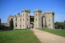 |
Raglan Castle |
Castle | Raglan | 51°46′13″N 2°50′59″W / 51.7702°N 2.8498°W, SO417085 |
An impressive late medieval (13th - 15th century) stone castle. | Monmouthshire | Medieval | MM005 |
 |
St Cadoc's Raglan, Churchyard Cross | Cross | Raglan | 51°45′53″N 2°51′05″W / 51.7646°N 2.8514°W, SO414077 |
Monmouthshire | Medieval | MM100 | |
 |
St Govan's Llangovan, Churchyard Cross | Cross | Raglan | 51°44′43″N 2°47′18″W / 51.7453°N 2.7882°W, SO456054 |
Monmouthshire | Medieval | MM327 | |
| St John's Llandenny, Churchyard Cross | Cross | Raglan | 51°43′51″N 2°50′54″W / 51.7309°N 2.8482°W, SO415039 |
Monmouthshire | Medieval | MM322 | ||
| St Martin's Pen-y-Clawdd, Churchyard Cross | Cross | Raglan | 51°46′00″N 2°47′39″W / 51.7667°N 2.7943°W, SO452078 |
Monmouthshire | Medieval | MM329 | ||
 |
Trecastle Motte and Bailey | Motte and Bailey | Raglan | 51°45′34″N 2°47′45″W / 51.7594°N 2.7957°W, SO451070 |
An oval motte with bailey to the south surrounded by a moat. | Monmouthshire | Medieval | MM098 |
 |
St Michael's Llanfihangel Rogiet, Churchyard Cross | Cross | Rogiet | 51°35′13″N 2°47′36″W / 51.5869°N 2.7934°W, ST451878 |
Monmouthshire | Medieval | MM325 | |
 |
Cas Troggy Castle | Castle | Shirenewton | 51°39′09″N 2°50′49″W / 51.6526°N 2.8469°W, ST415952 |
Small ruined fortified hunting lodge or manor house built by Roger Bigod around 1303. One of six castles around Wentwood Forest.[lower-alpha 2] | Monmouthshire | Medieval | MM015 |
 |
St Mary's Penterry, Churchyard Cross | Cross | Tintern | 51°41′07″N 2°41′46″W / 51.6854°N 2.6962°W, ST519987 |
Monmouthshire | Medieval | MM331 | |
 |
Tintern Abbey Inner Precinct |
Abbey | Tintern | 51°41′49″N 2°40′36″W / 51.6969°N 2.6768°W, SO533000 |
Monmouthshire | Medieval | MM102 | |
| Tintern Abbey, Precinct Wall | Wall | Tintern | 51°41′50″N 2°40′49″W / 51.6971°N 2.6802°W, SO530000 |
Monmouthshire | Medieval | MM157 | ||
| Tintern Abbey, Watergate | Gatehouse | Tintern | 51°41′53″N 2°40′41″W / 51.6981°N 2.678°W, SO532001 |
Monmouthshire | Medieval | MM265 | ||
 |
Medieval House Sites W of Trellech Church | Shrunken Medieval Village | Trellech United | 51°44′46″N 2°43′34″W / 51.746°N 2.7261°W, SO499055 |
Monmouthshire | Medieval | MM194 | |
| St Mary's Penallt, Churchyard Cross | Cross | Trellech United | 51°47′35″N 2°41′40″W / 51.7931°N 2.6944°W, SO522107 |
Monmouthshire | Medieval | MM146 | ||
 |
The Virtuous Well | Holy Well | Trellech United | 51°44′33″N 2°43′16″W / 51.7424°N 2.7212°W, SO503051 |
Monmouthshire | Medieval | MM171 | |
 |
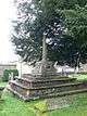
St Nicholas' Trellech, Churchyard Cross | Cross | Trellech United | 51°44′44″N 2°43′30″W / 51.7456°N 2.7249°W, SO500054 |
Five-stepped pedestal, large socketstone, with two sections of shaft and a modern cross-head, in St Nicholas' Churchyard, Trellech. | Monmouthshire | Medieval | MM107 |
 |
Trellech Cross Preaching Cross | Cross | Trellech United | 51°43′59″N 2°43′35″W / 51.733°N 2.7263°W, SO499040 |
Wayside cross. Two stone steps on a roadside grassy bank. | Monmouthshire | Medieval | MM108 |
 |
Trellech Shrunken Medieval Village | Shrunken Medieval Village | Trellech United | 51°44′32″N 2°43′23″W / 51.7422°N 2.723°W, SO501050 |
From 1250 to its decline around 1600, Trellech was a booming iron-melting centre. The scheduled area is close to the present village centre but an ongoing archaeological dig further south has found many building foundations. | Monmouthshire | Medieval | MM272 |
 |
Tump Terrett Castle Mound | Motte | Trellech United | 51°44′41″N 2°43′33″W / 51.7447°N 2.7257°W, SO499053 |
A steep-sided ditched mound (36m in diameter and 5.5m high). Mentioned in 1231 and later referred to as "site of" in 1306. Recent excavations and investigation suggest a Motte and Bailey castle, built early in the period of the Norman conquest of the area.[78]:332 | Monmouthshire | Medieval | MM016 |
 |
Usk Castle (Unoccupied parts) | Castle | Usk | 51°42′19″N 2°54′12″W / 51.7052°N 2.9033°W, SO376011 |
A substantial masonry castle dating from around 1138 and now generally ruinous. | Monmouthshire | Medieval | MM012 |
 |
Usk Priory Gatehouse | Gatehouse | Usk | 51°42′09″N 2°54′03″W / 51.7024°N 2.9009°W, SO378007 |
A surviving fragment of a Benedictine priory founded around 1135 and dissolved in 1536 | Monmouthshire | Medieval | MM090 |
 |
Chepstow Town Slipway | Quay | Chepstow | 51°38′40″N 2°40′07″W / 51.6445°N 2.6686°W, ST538941 |
A well preserved post-medieval slip compromising of a cambered cobbled slipway some 25m long by 2.6m wide, sloping at an angle of 10 degrees. The final 5.0m of the slipway forms a flight of shallow steps down to the low-tide mark in the River Wye | Monmouthshire | Post Medieval | MM301 |
| Hygga Farm Dovecote | Dovecote | Trellech United | 51°43′45″N 2°44′46″W / 51.7292°N 2.7462°W, SO485036 |
Monmouthshire | Post Medieval | MM150 | ||
 |
Disgwylfa Tramroads | Tramroad | Llanelly, (also Llangattock), (see also Powys) | 51°49′08″N 3°08′14″W / 51.8189°N 3.1371°W, SO217139 |
Brecknockshire | Post Medieval | MM340 | |
 |
Lower or Abbey Wireworks, Tintern | Iron forge | Tintern | 51°41′52″N 2°41′11″W / 51.6977°N 2.6864°W, SO526001 |
Early industrial site, manufacturing wire from the 16th to the 19th centuries. It was part of an integrated iron production system, sited along the Angidy Valley. The manufacture of wire was the final stage in the process, closest to the River Wye, at the foot of the valley. | Monmouthshire | Post Medieval | MM266 |
| Tintern Upper Wireworks (New Tongs Mill) | Leat | Tintern | 51°41′59″N 2°42′44″W / 51.6997°N 2.7123°W, SO508003 |
Monmouthshire | Post Medieval | MM268 | ||
| Whitebrook Wireworks Leat | Leat | Trellech United | 51°45′24″N 2°41′00″W / 51.7567°N 2.6833°W, SO529066 |
Monmouthshire | Post Medieval | MM292 | ||
 |
Cewere Quarry and Limekiln, Llanvair-Discoed | Quarry | Caerwent | 51°37′44″N 2°47′15″W / 51.629°N 2.7874°W, ST455925 |
A well-preserved limekiln and quarry with associated earthworks. The kiln is of a Wye Valley type, roughly 4m high and 6.5m long, built into the bank to the south of the quarry. | Monmouthshire | 19th Century | MM289 |
| Limekiln and Quarries at Craig-yr-Hafod | Limekiln | Llanfoist Fawr | 51°47′14″N 3°03′21″W / 51.7871°N 3.0558°W, SO272103 |
Monmouthshire | Post Medieval | MM278 | ||
| Pwll Du Limestone Quarry & Water Balance Lift | Industrial monument | Llanfoist Fawr | 51°47′51″N 3°05′12″W / 51.7974°N 3.0866°W, SO251115 |
Monmouthshire | Post Medieval | MM225 | ||
| Colwell Grove Limekiln and Quarry, Tintern | Limekiln | Tintern | 51°41′40″N 2°40′36″W / 51.6945°N 2.6768°W, ST533997 |
Monmouthshire | Post Medieval | MM290 | ||
 |
Clearwater Paper Mill | Mill | Trellech United | 51°45′27″N 2°40′49″W / 51.7575°N 2.6804°W, SO531067 |
Monmouthshire | Post Medieval | MM294 | |
| Whitebrook Wireworks | Iron forge | Trellech United | 51°45′16″N 2°40′50″W / 51.7545°N 2.6805°W, SO531064 |
Monmouthshire | Post Medieval | MM270 | ||
 |
Tramway Embankment of Grosmont Railway | Tramway embankment | Llanvihangel Crucorney | 51°53′06″N 2°58′13″W / 51.885°N 2.9704°W, SO333211 |
Monmouthshire | Post Medieval | MM199 | |
| Blorenge Quarries Tramroad | Tramroad | Llanfoist Fawr | 51°48′02″N 3°04′13″W / 51.8006°N 3.0703°W, SO262118 |
Monmouthshire | Post Medieval | MM288 | ||
 |
Blorenge Tunnel, Hill's Tramroad | Tramroad | Llanfoist Fawr | 51°48′35″N 3°03′30″W / 51.8098°N 3.0583°W, SO271128 |
Tunnel, length approximately 40m, carrying Hill's Tramroad. On the north slope of the Blorenge. | Monmouthshire | Post Medieval | MM275 |
 |
Hill's Tramroad Inclines, Llanfoist | Tramroad | Llanfoist Fawr | 51°48′31″N 3°02′52″W / 51.8085°N 3.0478°W, SO278127 |
Monmouthshire | 19th Century | MM276 | |
 |
Pen-ffordd-goch Iron and coal patching, Blaenavon | Industrial monument | Llanfoist Fawr, (also Blaenavon), (see also Torfaen) | 51°47′18″N 3°04′38″W / 51.7882°N 3.0773°W, SO257104 |
Pen-ffordd-goch is also known as The Keepers. The site is connected with the Hanbury estate from the 17th century and Blaenavon Ironworks from about 1788. The remains of scouring and adit mining include leats, ponds, dams, scours, levels, tips, shaft mounds, tracks and tramroads. | Monmouthshire | 17th Century | MM227 |
| Carreg Maen Taro Ironstone Quarries | Quarry | Llanfoist Fawr, (also Blaenavon), (also Llanelly), (see also Torfaen) | 51°47′38″N 3°06′20″W / 51.794°N 3.1056°W, SO238111 |
Monmouthshire | Post Medieval | MM295 | ||
_(3).jpg) |
Pwll Du Tramroad Tunnel Northern Entrances & Site of Lower Bank | Industrial monument | Llanfoist Fawr | 51°47′55″N 3°05′45″W / 51.7987°N 3.0957°W, SO245116 |
Tunnel ran from near Blaenafon Iron works to link with the tramroad to the Brecon and Newport Canal at Llanfoist | Monmouthshire | 19th Century | MM224 |
| Tramroad Bridge, Bailey's Tramroad, Govilon | Bridge | Llanfoist Fawr | 51°48′50″N 3°04′31″W / 51.8138°N 3.0754°W, SO259133 |
Also known as Cwm Llanwenarth bridge | Monmouthshire | 19th Century | MM204 | |
| Perth-Hir House (Remains of) | House (domestic) | Llangattock-Vibon-Avel | 51°50′23″N 2°44′47″W / 51.8396°N 2.7463°W, SO486159 |
Monmouthshire | Post Medieval | MM144 | ||
| Blackcliff Wood Limekiln | Limekiln | Tintern | 51°40′49″N 2°40′37″W / 51.6803°N 2.6769°W, ST532981 |
Monmouthshire | Post Medieval | MM291 | ||
 |
Abbey Tintern Furnace | Industrial monument | Tintern | 51°41′57″N 2°42′18″W / 51.6992°N 2.705°W, SO513002 |
Angidy Ironworks. Also known as 'The Old Blast Furnace', it smelted Iron from the 1590s to the 1820s. It was a key part of the industrial metalworking of the Angidy Valley, producing iron for the wireworks further down the valley. | Monmouthshire | Post Medieval | MM197 |
| Coed-Ithel Iron Furnace | Kiln | Trellech United | 51°43′12″N 2°41′05″W / 51.7199°N 2.6847°W, SO527025 |
Early iron furnace. | Monmouthshire | Post Medieval | MM164 | |
| Woolpitch Wood Iron Furnace | Kiln | Trellech United | 51°44′25″N 2°44′21″W / 51.7402°N 2.7392°W, SO490048 |
Early iron furnace. | Monmouthshire | Post Medieval | MM177 | |
| Clydach Ironworks (remains) and Smart's Bridge | Industrial monument | Llanelly | 51°48′45″N 3°07′11″W / 51.8126°N 3.1196°W, SO229132 |
Brecknockshire | 18th Century (Ironworks) and 19th Century (Bridge) | BR161 | ||
| Gilwern Embankment | Industrial monument | Llanelly | 51°49′25″N 3°05′54″W / 51.8237°N 3.0982°W, SO244144 |
Monmouthshire | 18th Century | MM251 | ||
| Iron Furnace SW of Clydach | Industrial monument | Llanelly | 51°49′04″N 3°06′53″W / 51.8179°N 3.1148°W, SO232138 |
Llanelly Furnace. | Brecknockshire | 17th Century | BR160 | |
| Garnddyrys Ironworks (Site of) and adjacent Tramway | Industrial monument | Llanfoist Fawr | 51°48′00″N 3°04′39″W / 51.7999°N 3.0774°W, SO258118 |
Monmouthshire | Post Medieval | MM189 | ||
| The Graig Settlement | Settlement | Llanfoist Fawr | 51°50′27″N 3°04′51″W / 51.8409°N 3.0808°W, SO256163 |
Monmouthshire | Post Medieval | MM273 | ||
 |
Redbrook Incline Overbridge | Bridge | Monmouth | 51°47′21″N 2°40′24″W / 51.7892°N 2.6733°W, SO536102 |
Carried Redbrook tin plate tramway until closure in 1872 | Monmouthshire | Post Medieval | MM203 |
| Royal Navy Propellant Factory, Caerwent, Nitro-glycerine Hill | Industrial building | Caerwent | 51°37′22″N 2°44′55″W / 51.6228°N 2.7487°W, ST482918 |
An extensive site chosen for development for propellant manufacture due to natural slope and availability of water. | Monmouthshire | 20th Century | MM352 | |
| Royal Navy Propellant Factory, Caerwent Guided Weapons Scheme Static Firing Bay | Royal Naval Depot | Caerwent | 51°37′31″N 2°45′20″W / 51.6253°N 2.7555°W, ST478921 |
Built in 1959 to research and test the rocket booster engines for the Royal Navy's Sea Slug surface-to-air missiles | Monmouthshire | 20th Century | MM341 | |
| Dyne Steel Incline | Incline | Llanfoist Fawr, (also Blaenavon), (see also Torfaen) | 51°47′36″N 3°06′06″W / 51.7933°N 3.1017°W, SO241110 |
Monmouthshire | Post Medieval | MM280 | ||
 |
The Alcove, Piercefield | Folly | St Arvans | 51°38′59″N 2°40′52″W / 51.6496°N 2.6811°W, ST529947 |
Semi-octagonal platform with a semi-circular stone seat with views of the Wye Valley and cliffs below Chepstow castle. The first of the viewpoints constructed in around 1850, for the Piercefield walk. Originally roofed with an arch.[205] | Monmouthshire | 18th Century | MM285 |
| The Cold Bath, Piercefield | Bath-house | St Arvans | 51°40′05″N 2°41′18″W / 51.6681°N 2.6884°W, ST524968 |
Remains of a small rectangular brick and stone building which housed a tile-lined plunge pool. | Monmouthshire | 18th Century | MM281 | |
 |
The Giant's Cave, Piercefield | Cave | St Arvans | 51°39′48″N 2°41′20″W / 51.6633°N 2.6888°W, ST524962 |
Curved tunnel cut into the rockface. One of the features of the Piercefield Walk. | Monmouthshire | 18th Century | MM282 |
 |
The Grotto, Piercefield | Grotto | St Arvans | 51°39′30″N 2°40′36″W / 51.6584°N 2.6766°W, ST532957 |
A small domed alcove made of brick and built to provide a shaded seat with spectacular views across the Wye Valley, and originally lined with iron cinders, copper and quartz.[205] One of the features on the Piercefield Walk. | Monmouthshire | 18th Century | MM283 |
 |
The Platform, Piercefield | Folly | St Arvans | 51°39′18″N 2°40′36″W / 51.655°N 2.6767°W, ST532953 |
Monmouthshire | 18th Century | MM284 |

See also
- List of Cadw properties
- List of castles in Wales
- List of hill forts in Wales
- Historic houses in Wales
- List of monastic houses in Wales
- List of museums in Wales
- List of Roman villas in Wales
- Grade I listed buildings in Monmouthshire
- Grade II* listed buildings in Monmouthshire
- List of Scheduled Monuments in Newport
- List of Scheduled Monuments in Torfaen
- List of hill forts in Monmouthshire
Notes
The Cadw schedule on which this list is based makes no distinctions between different prehistoric periods. The following notes explain where period classifications have been refined, based on the (cited) records from RCAHMW and/or Glamorgan-Gwent Archaeological Trust.
- ↑ The Cadw spreadsheet lists sites by vary broad categories, for example, Prehistoric covers Paleolithic to Iron Age. Where possible, the Period has been changed, based on the (cited) records from Coflein and/or GGAT.
- 1 2 3 The six castles are Cas Troggy, Dinham, Llanvaches, Llanvair, Pencoed, and Penhow.[73]
- 1 2 3 The Three Castles in the Monnow valley (Grosmont, Skenfrith and White castles) were brought together under a single lordship by King Stephen in 1138. The castles share many features of design and construction, and the existing remains all date from the 11th century, when under the control of Hubert de Burgh, with some later building. All three castles remained in common ownership until 1902,[72]:46 and are all now in state care, under the guardianship of Cadw. The castles are linked by the Three Castles Walk.
References
- Coflein is the online database of RCAHMW: Royal Commission on the Ancient and Historical Monuments of Wales, GGAT is the Glamorgan-Gwent Archaeological Trust, Cadw is the Welsh Historic Monuments Agency
- ↑ Cadw: Ancient Monuments and Scheduling. Accessed 25 April 2013
- ↑ Cadw will send their list as a spreadsheet, or other electronic formats, on request, as indicated at www.whatdotheyknow.com. This list uses information dated May 2012
- ↑ Cadw SAM: MM031 Grey Hill Stone Circle. coflein NPRN: 307979. GGAT PRN: 00987g.
- ↑ Cadw SAM: MM206 Long Barrow and Round Barrow at Thornwell Farm. Neolithic long barrow - coflein NPRN: 300127 and GGAT PRN: 04432g. Bronze Age round barrow - coflein NPRN: 300128 and GGAT PRN: 04440g.
- ↑ Cadw SAM: MM160 St Peter's Cave. coflein NPRN: 275976. GGAT PRN: 02216g.
- ↑ Cadw SAM: MM106 Llangibby Bottom Standing Stone. coflein NPRN: 307863. GGAT PRN: 00358g.
- ↑ Cadw SAM: MM018 Heston Brake Long Barrow. coflein NPRN: 300078. GGAT PRN: 01147g.
- ↑ Chris Barber, ed. (2000). Hando's Gwent. I (2nd ed.). Abergavenny: Blorenge Books.
- ↑ Cadw SAM: MM068 Standing Stone 252m South of Bencroft Lane. coflein NPRN: 307951. GGAT PRN: 00468g.
- ↑ Cadw SAM: MM013 Gaer-Llwyd Burial Chamber. coflein NPRN: 93391. GGAT PRN: 01140g.
- ↑ Hando, Fred J. (1954). Monmouthshire Sketch Book. Newport: R. H. Johns.
- ↑ Cadw SAM: MM017 Harold's Stones, Standing Stones. coflein NPRN: 221159. GGAT PRN: 00854g.
- ↑ Powell, M J (1995). "Astronomical Indications at a Bell-barrow in South Wales". Journal for the History of Astronomy, Archaeoastronomy Supplement. Science History Publications. 26: S49. Bibcode:1995JHAS...26...49P. Retrieved 24 Jan 2014.
- ↑ Cadw SAM: MM151 Crick Round Barrow. coflein NPRN: 307966. GGAT PRN: 01057g.
- ↑ Cadw SAM: MM333 Foresters' Oaks round barrow. coflein NPRN: 401578. GGAT PRN: 08654g.
- ↑ Cadw SAM: MM179 Round Barrow 250m North East of Five Lanes. coflein NPRN: 93494. GGAT PRN: 08454g.
- ↑ Cadw SAM: MM343 Cwm Bwchel Round Cairn. coflein NPRN: 306269. GGAT PRN: 01753g.
- ↑ Cadw SAM: MM302 Garreg Las Round Cairns. coflein NPRN: 417946 and coflein NPRN: 417947. GGAT PRN: 08114g.
- ↑ Cadw SAM: MM342 Graig Ddu Round Cairn. coflein NPRN: 300042. GGAT PRN: 01751g.
- ↑ Cadw SAM: MM261 Hatterrall Hill Enclosure. coflein NPRN: 306449. GGAT PRN: 08958g.
- ↑ Cadw SAM: MM304 Loxidge Tump cairn. coflein NPRN: 306273. GGAT PRN: 01748g.
- ↑ Cadw SAM: MM299 Rhiw Arw cairn. coflein NPRN: 406539. GGAT PRN: 08459g.
- ↑ Cadw SAM: MM303 Three Wells Round Cairn. coflein NPRN: 417948. GGAT PRN: 08115g.
- ↑ Cadw SAM: MM286 Chepstow Park Wood Cairn. coflein NPRN: 276015. GGAT PRN: 07057g.
- ↑ Cadw SAM: MM219 Cairn on the Blorenge. coflein NPRN: 306255. GGAT PRN: 01776g.
- ↑ Cadw SAM: MM209 Carn-y-Defaid Round Cairns. coflein NPRN: 306237 (South cairn) and coflein NPRN: 306238 (North cairn). GGAT PRN: 08442g.
- ↑ Cadw SAM: MM112 Middle Hendre Round Barrow. coflein NPRN: 306499. GGAT PRN: 01437g.
- ↑ Cadw SAM: MM081 Round Barrow 180m North of Ty-Canol. coflein NPRN: 306415. GGAT PRN: 01839g.
- ↑ Cadw SAM: MM167 Two Round Barrows 180m North West of Wentwood Lodge. Coflein NPRNs: coflein NPRN: 93483 and coflein NPRN: 93484. GGAT PRN: 01020g and GGAT PRN: 01021g.
- ↑ Cadw SAM: MM191 Three Round Barrows in Lower Hale Wood. coflein NPRN: 300129, coflein NPRN: 300130, and coflein NPRN: 300131. GGAT PRN: 03940g, GGAT PRN: 00724g, and GGAT PRN: 00725g.
- ↑ Cadw SAM: MM178 Camp 650m South of Ty Freeman. coflein NPRN: 91944. GGAT PRN: 02057g.
- ↑ Cadw SAM: BR405: Defended Enclosure 350m NNW of Ty-Uchaf. coflein NPRN: 306249. GGAT PRN: 01958g.
- ↑ Cadw SAM: MM258 Buckholt Wood Hilltop Enclosure. coflein NPRN: 275998. GGAT PRN: 01461g.
- ↑ Cadw SAM: MM048 Sudbrook Camp and Sudbrook Chapel. Camp - coflein NPRN: 94873 and GGAT PRN: 01142g. Chapel - coflein NPRN: 96627 and GGAT PRN: 01145g.
- ↑ Cadw SAM: MM139 Bishop Barnet's Wood Camp. coflein NPRN: 308008. GGAT PRN: 01161g.
- 1 2 3 4 5 6 7 8 9 10 11 12 13 14 Wiggins, Hannah (March 2006). "Prehistoric defended enclosures in Gwent" (PDF). Glamorgan Gwent Archaeological Trust Ltd. Retrieved 8 January 2014.
- ↑ Cadw SAM: MM024 Llanmelin Wood Camps. coflein NPRN: 301559. GGAT PRN: 01026g.
- ↑ Cadw SAM: MM069 The Larches Camp. coflein NPRN: 307950. GGAT PRN: 00473g.
- ↑ Cadw SAM: MM093 Bulwarks Camp. coflein NPRN: 301207. GGAT PRN: 01193g.
- ↑ Cadw SAM: MM064 Pen-Twyn Earthwork. coflein NPRN: 94878. GGAT PRN: 01607g.
- ↑ Cadw SAM: MM148 Twyn-y-Gaer Camp. coflein NPRN: 300043. GGAT PRN: 01713g.
- ↑ Cadw SAM: MM078 Llancayo Camp. coflein NPRN: 306434. GGAT PRN: 02166g.
- ↑ Cadw SAM: MM075 Coed y Bwnydd Camp. coflein NPRN: 306420. GGAT PRN: 02171g.
- ↑ Cadw SAM: MM062 Gaer Fawr hillfort. coflein NPRN: 300081. GGAT PRN: 01131g.
- ↑ Cadw SAM: MM105 Great House Camp. coflein NPRN: 306492. GGAT PRN: 00942g.
- ↑ Cadw SAM: MM079 Cae Camp. coflein NPRN: 307883. GGAT PRN: 00387g.
- ↑ Cadw SAM: MM135 Candwr Camp. coflein NPRN: 220952. GGAT PRN: 00645g.
- ↑ Cadw SAM: MM127 Wilcrick Hill Camp. coflein NPRN: 307946. GGAT PRN: 00474g.
- ↑ Cadw SAM: MM025 Gaer Hill Camp, Penterry. coflein NPRN: 307991. GGAT PRN: 00745g.
- ↑ Cadw SAM: MM020 Pierce Wood Camps. Westerly fort - coflein NPRN: 307997 and GGAT PRN: 00773g. Easterly fort - coflein NPRN: 307998 and GGAT PRN: 00772g.
- ↑ Cadw SAM: MM027 Blackcliff Wood Camp. coflein NPRN: 94864. GGAT PRN: 00748g.
- ↑ Cadw SAM: MM077 Gaer 594m SW of Trellech Cross. coflein NPRN: 306487. GGAT PRN: 00972g.
- ↑ Cadw SAM: MM193 Abergavenny Roman Fort. coflein NPRN: 306295. GGAT PRN: 01761g.
- ↑ Cadw SAM: MM001 Caerwent Roman City. coflein NPRN: 93753. GGAT PRN: 01055g.
- ↑ Cadw SAM: MM334 Church Farm Romano-British settlement. coflein NPRN: 404957. GGAT PRN: 06143g.
- ↑ Cadw SAM: MM169 Enclosure revealed by Aerial Photography. coflein NPRN: 268154. GGAT PRN: 08949g.
- ↑ Cadw SAM: MM019 Portskewett Hill Roman Site. coflein NPRN: 307944. GGAT PRN: 00495g.
- ↑ Cadw SAM: MM155 Usk Roman Site. coflein NPRN: 93470. GGAT PRN: 01998g.
- ↑ Cadw SAM: MM350 Five Lanes Roman Site. coflein NPRN: 405453. GGAT PRN: 00983g.
- ↑ Cadw SAM: MM152 Whitewall Brake Roman Site. coflein NPRN: 307961. GGAT PRN: 01034g.
- ↑ Cadw SAM: MM195 Little Hadnock Roman Villa, Dixton Newtown. coflein NPRN: 400333. GGAT PRN: 02194g.
- ↑ Cadw SAM: MM351 Wyndcliff Roman Site. coflein NPRN: 410589. GGAT PRN: 00764g.
- ↑ Cadw SAM: MM260 Hatterrall Hill Cross Ridge Dyke. coflein NPRN: 306448. GGAT PRN: 04513.0g.
- 1 2 Cadw SAM: MM182 Remains of St Michael's Chapel and Skirrid Fawr Defended Enclosure. Chapel - coflein NPRN: 306440 and GGAT PRN: 01473g. Enclosure - coflein NPRN: 400378 and GGAT PRN: 01497g.
- ↑ Cadw SAM: MM156 Cross on Croes Lwyd Farm. coflein NPRN: 306485. GGAT PRN: 00794g.
- ↑ Cadw SAM: MM355 St Arvan's Church Cross-slab. coflein NPRN: 413305. GGAT PRN: 00775g.
- ↑ Cadw SAM: MM010 Abergavenny Bridge. coflein NPRN: 24229. GGAT PRN: 01762g.
- ↑ Cadw SAM: MM056 Abergavenny Castle. coflein NPRN: 94876. GGAT PRN: 01759g.
- ↑ Cadw SAM: MM183 Area of Conventual Buildings, St Mary's Priory. coflein NPRN: 20703. GGAT PRN: 01325g.
- ↑ Cadw SAM: MM053 Crick Medieval House. coflein NPRN: 36732. GGAT PRN: 01062g.
- ↑ Cadw SAM: MM051 Crick Moated Site. coflein NPRN: 307965. GGAT PRN: 01061g.
- 1 2 3 4 5 6 7 Salter, Mike (2002). Castles of Gwent, Glamorgan & Gower (2nd ed.). Malvern: Folly Publications. ISBN 1-871-73161-5.
- ↑ Nicholson, G (1840). Cambrian Traveller's Guide (3rd ed.). London: Longman, Orme, Brown, Green, & Longmans. p. 168.
- ↑ Cadw SAM: MM153 Dinham Castle. coflein NPRN: 307967. GGAT PRN: 01049g.
- ↑ Cadw SAM: MM047 Llanvair Castle. coflein NPRN: 307984. GGAT PRN: 00996g.
- ↑ Cadw SAM: MM154 St Brides Netherwent Deserted Village. coflein NPRN: 15512. GGAT PRN: 00469g.
- ↑ Cadw SAM: MM050 Caldicot Castle (unoccupied parts). coflein NPRN: 93411. GGAT PRN: 00513g.
- 1 2 3 4 5 Phillips, Neil (2008). Earthwork Castles of Gwent and Ergyng AD 1050 – 1250 PhD Thesis, University of Sheffield (2005). 1. York: Archaelogy Data Service. doi:10.5284/1000209.
- ↑ Cadw SAM: MM026 The Berries Mound & Bailey Castle. coflein NPRN: 307943. GGAT PRN: 00496g.
- ↑ Cadw SAM: MM003 Chepstow Castle. coflein NPRN: 95237. GGAT PRN: 01173g.
- ↑ Cadw SAM: MM002 Chepstow Town Wall and Gate. coflein NPRN: 302128. GGAT PRN: 01186g.
- ↑ Cadw SAM: MM142 Cwmyoy Churchyard Cross. coflein NPRN: 306286. GGAT PRN: 01714g.
- ↑ Cadw SAM: MM004 Llanthony Priory. coflein NPRN: 95238. GGAT PRN: 01720g.
- ↑ Cadw SAM: MM145 Pen y Clawdd Castle Mound. coflein NPRN: 306454. GGAT PRN: 01622g.
- ↑ Cadw SAM: MM210 Penbidwal Moated Site. coflein NPRN: 300135. GGAT PRN: 03837g.
- ↑ Cadw SAM: MM063 The Moat Mound and Bailey Castle, Tre Fedw. coflein NPRN: 306463. GGAT PRN: 01627g.
- ↑ Cadw SAM: MM103 Chepstow Park Wood Moated Site. coflein NPRN: 307956. GGAT PRN: 01101g.
- ↑ Cadw SAM: MM067 Cwrt y Gaer Ringwork. coflein NPRN: 300082. GGAT PRN: 01134g.
- ↑ Cadw SAM: MM104 Kilgwrrwg Churchyard Cross. coflein NPRN: 307957. GGAT PRN: 01087g.
- ↑ Cadw SAM: MM330 St. Thomas a Becket's Churchyard Cross, Wolvesnewton. coflein NPRN: not yet identified. GGAT PRN: 01084g.
- ↑ Cadw SAM: MM138 Goytre Wood Castle Mound. coflein NPRN: 306450. GGAT PRN: 01635g.
- ↑ Cadw SAM: MM007 Grosmont Castle. coflein NPRN: 93388. GGAT PRN: 01664g.
- ↑ Cadw SAM: MM147 Grosmont Churchyard Cross. coflein NPRN: 306507. GGAT PRN: 01676g.
- ↑ Cadw SAM: MM319 St. Cadoc's Churchyard Cross, Llangattock Lingoed. coflein NPRN: 306451. GGAT PRN: 08111g.
- ↑ Cadw SAM: MM317 St. James's Churchyard Cross, Llanvetherine. coflein NPRN: 306438. GGAT PRN: 01416g.
- ↑ Cadw SAM: MM321 St. David's Churchyard Cross, Trostre. coflein NPRN: 406543. GGAT PRN: 02033g.
- ↑ Cadw SAM: MM122 Bettws Newydd Churchyard Cross-Base. coflein NPRN: 306419. GGAT PRN: 01862g.
- ↑ Cadw SAM: MM116 Llanarth Churchyard Cross-Base. coflein NPRN: 306443. GGAT PRN: 01283g.
- ↑ Cadw SAM: MM318 St. Mabli's Churchyard Cross, Llanvapley. coflein NPRN: 306442. GGAT PRN: 01310g.
- ↑ Cadw SAM: MM323 St. Peter's Churchyard Cross, Bryngwyn. coflein NPRN: 306425. GGAT PRN: 01869g.
- ↑ Cadw SAM: MM080 Twyn y Cregen Castle Mound. coflein NPRN: 306421. GGAT PRN: 01834g.
- ↑ Cadw SAM: MM099 Wern-y-Cwrt Castle Mound. coflein NPRN: 306424. GGAT PRN: 01874g.
- ↑ Cadw SAM: MM335 Graig Foel medieval ringwork. coflein NPRN: 91945. GGAT PRN: 02330g.
- ↑ Cadw SAM: BR010 Battle Tump. coflein NPRN: 308382. GGAT PRN: 01957g.
- ↑ Cadw SAM: MM118 Llanwenarth Churchyard Cross-Base. coflein NPRN: 306256. GGAT PRN: 01778g.
- ↑ Cadw SAM: MM306 St. Faith's Churchyard Cross, Llanfoist. coflein NPRN: 306257. GGAT PRN: 01793g.
- ↑ Cadw SAM: MM215 Area of Deserted Medieval Settlement, Skenfrith. coflein NPRN: 54442. GGAT PRN: 04691g.
- ↑ Cadw SAM: MM085 Newcastle Castle. coflein NPRN: 306494. GGAT PRN: 01515g.
- ↑ Cadw SAM: MM158 Site of Grace Dieu Abbey. coflein NPRN: 306498. GGAT PRN: 01454g.
- ↑ Cadw SAM: MM088 Skenfrith Castle. coflein NPRN: 93431. GGAT PRN: 01698g.
- ↑ Cadw SAM: MM061 Llangwm Mound & Bailey Castle. coflein NPRN: 221427. GGAT PRN: 01123g.
- ↑ Cadw SAM: MM074 Ringwork NE of New House. coflein NPRN: 93422. GGAT PRN: 00907g.
- ↑ Cadw SAM: MM332 Ffynnon Cybi (St. Cybi's Well). coflein NPRN: 407448. GGAT PRN: 00354g.
- ↑ Cadw SAM: MM109 Llangibby Castle (Castell Tregrug). coflein NPRN: 94896. GGAT PRN: 00323g.
- ↑ Cadw SAM: MM110 Llangibby Castle Mound. coflein NPRN: 307862. GGAT PRN: 00336g.
- ↑ Cadw SAM: MM086 Castle Arnold. coflein NPRN: 275974. GGAT PRN: 01354g.
- ↑ Cadw SAM: MM123 Llangattock Nigh Usk Churchyard Cross. coflein NPRN: 306428. GGAT PRN: 02168g.
- ↑ Cadw SAM: MM117 Llanthewy-Rhytherch Churchyard Cross-Base. coflein NPRN: 306445. GGAT PRN: 01361g.
- ↑ Cadw SAM: MM124 Llanvihangel Nigh Usk Churchyard Cross. coflein NPRN: 306429. GGAT PRN: 02170g.
- ↑ Cadw SAM: MM082 St Mary's Yard Castle Mound. coflein NPRN: 306430. GGAT PRN: 01936g.
- ↑ Cadw SAM: MM307 St. Bartholomew's Churchyard Cross, Llanover. coflein NPRN: 306426. GGAT PRN: 01908g.
- ↑ Cadw SAM: MM312 St. Bridget's Churchyard Cross, Llansantffraed. coflein NPRN: 306418. GGAT PRN: 01837g.
- ↑ Cadw SAM: MM326 St. Mary's Churchyard Cross, Llanfair Cilgedyn. coflein NPRN: 306416. GGAT PRN: 01838g.
- ↑ Cadw SAM: MM094 Hen Gwrt Moated Site. coflein NPRN: 94890. GGAT PRN: 01388g.
- ↑ Cadw SAM: MM097 Penrhos Mound & Bailey Castle. coflein NPRN: 306505. GGAT PRN: 01543g.
- ↑ Cadw SAM: MM006 White Castle. coflein NPRN: 94853. GGAT PRN: 01407g.
- ↑ Cadw SAM: MM060 Coed-Cwnwr Moated Site. coflein NPRN: 94877. GGAT PRN: 01111g.
- ↑ Cadw SAM: MM040 Moated Site North West of Bertholey House. coflein NPRN: 307896. GGAT PRN: 00382g.
- ↑ Cadw SAM: MM180 Medieval Building adjoining Magor Churchyard. coflein NPRN: 20712. GGAT PRN: 00453g.
- ↑ Cadw SAM: MM198 Medieval Moated Site 400m N of Undy Church. coflein NPRN: 95243. GGAT PRN: 00455g.
- ↑ Cadw SAM: MM226 Relict Seawall alongside Collister Pill Reen. coflein NPRN: 275980. GGAT PRN: 04793g and GGAT PRN: 04794g.
- ↑ Cadw SAM: MM314 St. Mary's Churchyard Crosses, Magor. coflein NPRN: 307947. GGAT PRN: 00452g.
- ↑ Cadw SAM: MM126 Undy Churchyard Cross. coflein NPRN: 307949. GGAT PRN: 00464g.
- ↑ Cadw SAM: MM187 Moated Site South of Moynes Court. coflein NPRN: 275978. GGAT PRN: 01215g.
- ↑ Cadw SAM: MM095 Runston Medieval Village Site & Runston Chapel. Chapel - coflein NPRN: 93433 and GGAT PRN: 01401g. Village Site - coflein NPRN: 15511 and GGAT PRN: 01043g
- ↑ Cadw SAM: MM113 Dingestow Castle. coflein NPRN: 306496. GGAT PRN: 01450g.
- ↑ Cadw SAM: MM114 Mill Wood Castle Mound. coflein NPRN: 306497. GGAT PRN: 01449g.
- ↑ Cadw SAM: MM111 Mitchel Troy Churchyard Cross. coflein NPRN: 93442. GGAT PRN: 01441g.
- ↑ Cadw SAM: MM213 Moated Site at Coed-y-Fedw. coflein NPRN: 95255. GGAT PRN: 03604g.
- ↑ Cadw SAM: MM328 St. Catwg's Churchyard Cross, Cwmcarfan. coflein NPRN: 407449. GGAT PRN: 00848g.
- ↑ Cadw SAM: MM316 St. Dingad's Churchyard Cross, Dingestow. coflein NPRN: 306495. GGAT PRN: 01457g.
- ↑ Cadw SAM: MM320 St. Mary's Churchyard Cross, Tregaer. coflein NPRN: 306506. GGAT PRN: 01559g.
- ↑ Cadw SAM: MM036 Clawdd Du. coflein NPRN: 306510. GGAT PRN: 01262g.
- ↑ Cadw SAM: MM125 Dixton Mound. coflein NPRN: 306512. GGAT PRN: 01222g.
- ↑ Cadw SAM: MM159 Monmouth Castle. coflein NPRN: 93473. GGAT PRN: 01234g.
- ↑ Cadw SAM: MM008 Monnow Bridge. coflein NPRN: 24219. GGAT PRN: 01256g.
- ↑ Cadw SAM: MM308 St. Peter's Churchyard Cross, Dixton. coflein NPRN: 306511. GGAT PRN: 08118g.
- ↑ Cadw SAM: MM029 Harold's House (site of). coflein NPRN: 15506. GGAT PRN: 00505g.
- ↑ Cadw SAM: MM315 St. Mary's Churchyard Cross, Portskewett. coflein NPRN: 307945. GGAT PRN: 00507g.
- ↑ Cadw SAM: MM005 Raglan Castle. coflein NPRN: 93387. GGAT PRN: 00814g.
- ↑ Cadw SAM: MM100 Raglan Churchyard Cross. coflein NPRN: 306481. GGAT PRN: 00900g.
- ↑ Cadw SAM: MM327 St. Govan's Churchyard Cross, Llangovan. coflein NPRN: 306477. GGAT PRN: 00861g.
- ↑ Cadw SAM: MM322 St. John's Churchyard Cross, Llandenny. coflein NPRN: 306491. GGAT PRN: 00933g.
- ↑ Cadw SAM: MM329 St. Martin's Churchyard Cross, Pen y Clawdd. coflein NPRN: 306479. GGAT PRN: 00874g.
- ↑ Cadw SAM: MM098 Trecastle Motte and Bailey. coflein NPRN: 306478. GGAT PRN: 00890g.
- ↑ Cadw SAM: MM325 St. Michael's Churchyard Cross, Llanfihangel Rogiet. coflein NPRN: 307942. GGAT PRN: 00487g.
- ↑ Cadw SAM: MM015 Cas Troggy Castle. coflein NPRN: 307959. GGAT PRN: 01120g.
- ↑ Cadw SAM: MM331 St. Mary's Churchyard Cross, Penterry. coflein NPRN: 307992. GGAT PRN: 00763g.
- ↑ Cadw SAM: MM102 Tintern Abbey, Inner Precinct. coflein NPRN: 359. GGAT PRN: 00713g.
- ↑ Cadw SAM: MM157 Tintern Abbey, Precinct Wall. coflein NPRN: 275975. GGAT PRN: 00714g.
- ↑ Cadw SAM: MM265 Tintern Abbey, Watergate. coflein NPRN: 276003. GGAT PRN: 00717g.
- ↑ Cadw SAM: MM194 Medieval House Sites W of Trellech Church. coflein NPRN: 15514. GGAT PRN: 02189g.
- ↑ Cadw SAM: MM146 Penallt Churchyard Cross. coflein NPRN: 306513. GGAT PRN: 01291g.
- ↑ Cadw SAM: MM171 The Virtuous Well. coflein NPRN: 32405. GGAT PRN: 00678g.
- ↑ Cadw SAM: MM107 Trellech Churchyard Cross. coflein NPRN: 306508. GGAT PRN: 00691g.
- ↑ Cadw SAM: MM108: Trellech Cross Cross-Base. coflein NPRN: 306488. GGAT PRN: 00965g.
- ↑ Cadw SAM: MM272 Trellech Shrunken Medieval Village. coflein NPRN: 300132. GGAT PRN: 04291g.
- ↑ Cadw SAM: MM016 Tump Terrett Castle Mound. coflein NPRN: 306480. GGAT PRN: 00855g.
- ↑ Cadw SAM: MM012 Usk Castle (Unoccupied Parts). coflein NPRN: 94856. GGAT PRN: 02021g.
- ↑ Cadw SAM: MM090 Usk Priory Gatehouse. coflein NPRN: 20702. GGAT PRN: 02019g.
- ↑ Cadw SAM: MM301 Chepstow Town Slipway. coflein NPRN: 401823. GGAT PRN: 05478g.
- ↑ Cadw SAM: MM150 Dovecot at Hygga Farm. coflein NPRN: 43258. GGAT PRN: 00969g.
- ↑ Cadw SAM: MM340 Disgwylfa Tramroads. coflein NPRN: 291876.
- ↑ Cadw SAM: MM266 Lower or Abbey Wireworks, Tintern. coflein NPRN: 40490. GGAT PRN: 00709g.
- ↑ Cadw SAM: MM268 Tintern Upper Wireworks (New Tongs Mill). coflein NPRN: 276004. GGAT PRN: 09513g.
- ↑ Cadw SAM: MM292 Whitebrook Wireworks Leat. coflein NPRN: 276019.
- ↑ Cadw SAM: MM289 Cewere Quarry and Limekiln, Llanvair-Discoed. coflein NPRN: 276016. GGAT PRN: 07134g (Quarry). GGAT PRN: 07133g (Limekiln).
- ↑ Cadw SAM: MM278 Limekiln and Quarries at Craig-yr-Hafod. coflein NPRN: 276009. GGAT PRN: 07829g.
- ↑ Cadw SAM: MM225 Pwll Du Limestone Quarry & Water Balance Lift. coflein NPRN: 85859 (Quarry) and coflein NPRN: 91634 (Balance Lift). GGAT PRN: 05346g.
- ↑ Cadw SAM: MM290 Colwell Grove Limekiln and Quarry, Tintern. coflein NPRN: 276017. GGAT PRN: 07507g (Limekiln) and GGAT PRN: 07508g (Quarry).
- ↑ Cadw SAM: MM294 Clearwater Paper Mill. coflein NPRN: 41228. GGAT PRN: 00665g.
- ↑ Cadw SAM: MM270 Site of Wireworks at Whitebrook. coflein NPRN: 276006. GGAT PRN: 06255g.
- ↑ Cadw SAM: MM199 Tramway Embankment of Grosmont Railway. coflein NPRN: 34971. GGAT PRN: 00201g.
- ↑ Cadw SAM: MM288 Blorenge Quarries Tramroad. coflein NPRN: 85814. GGAT PRN: 07827.0g.
- ↑ Cadw SAM: MM275 Blorenge Tunnel, Hill's Tramroad. coflein NPRN: 91616. GGAT PRN: 07834.1g.
- ↑ Cadw SAM: MM276 Hill's Tramroad Inclines, Llanfoist. coflein NPRN: 405096. GGAT PRN: 07835.0g.
- ↑ Cadw SAM: MM227 Iron and coal patching at Pen-ffordd-goch. coflein NPRN: 308295. GGAT PRN: 00056g.
- ↑ Cadw SAM: MM295 Ironstone Quarries at Carreg Maen Taro. coflein NPRN: 260542. GGAT PRN: 03552g.
- ↑ Cadw SAM: MM224 - Pwll Du Tramroad Tunnel Northern Entrances & Site of Lower Bank. coflein NPRN: 34976 North portal and coflein NPRN: 91754 North-east portal. GGAT PRN: 04693g.
- ↑ Cadw SAM: MM204 Tramroad Bridge, Bailey's Tramroad, Govilon. coflein NPRN: 34949. GGAT PRN: 02349g.
- ↑ Cadw SAM: MM144 Perth-Hir House (Remains of). coflein NPRN: 20651. GGAT PRN: 01498g.
- ↑ Cadw SAM: MM291 Blackcliff Wood Limekiln. coflein NPRN: 276018. GGAT PRN: 07070g.
- ↑ Cadw SAM: MM197 Old Furnace Blast Furnace. coflein NPRN: 34136. GGAT PRN: 00712g.
- ↑ Cadw SAM: MM164 Early Iron Furnace at Coed-Ithel. coflein NPRN: 34131. GGAT PRN: 00735g.
- ↑ Cadw SAM: MM177 Early Iron Furnace in Woolpitch Wood. coflein NPRN: 34144. GGAT PRN: 00971g.
- ↑ Cadw SAM: BR161 Clydach Ironworks (remains) and Smart's Bridge. Ironworks - coflein NPRN: 34030 and GGAT PRN: 02476g. Bridge - coflein NPRN: 34633. GGAT PRN: 03204g.
- ↑ Cadw SAM: MM251 Gilwern Embankment. coflein NPRN: 34371. GGAT PRN: 03199g.
- ↑ Cadw SAM: BR160 Iron Furnace SW of Clydach. coflein NPRN: 34029. GGAT PRN: 02485g.
- ↑ MM189: Garnddyrys Ironworks (Site of) and adjacent Tramway. coflein NPRN: 34137 (Ironworks) and coflein NPRN: 34965 (Tramway). GGAT PRN: 03939g.
- ↑ Cadw SAM: MM273 The Graig Settlement. coflein NPRN: 276007. GGAT PRN: 05817g through to GGAT PRN: 05857g.
- ↑ Cadw SAM: MM203 Redbrook Incline Overbridge. coflein NPRN: 34994. GGAT PRN: 02195g.
- ↑ Cadw SAM: MM352 Royal Naval Propellant Factory Caerwent, Nitro-glycerine Hill. coflein NPRN: 96062. GGAT PRN: 09218g.
- ↑ Cadw SAM: MM341 Royal Naval Propellant Factory Guided Weapons Scheme Static Firing Bay. coflein NPRN: 407506. GGAT PRN: 09016g.
- ↑ Cadw SAM: MM280 Dyne Steel Incline. coflein NPRN: 260302. GGAT PRN: 05493.0g.
- 1 2 "Picturesque Piercefield" (PDF). Wye Valley Area of Outstanding Beauty Partnership. 2012. Retrieved 26 Jan 2014.
- ↑ Cadw SAM: MM285 The Alcove, Piercefield. coflein NPRN: 276014. GGAT PRN: 07830g.
- ↑ Cadw SAM: MM281 The Cold Bath, Piercefield. coflein NPRN: 276011. GGAT PRN: 07831g.
- ↑ Cadw SAM: MM282 The Giant's Cave, Piercefield. coflein NPRN: 276012. GGAT PRN: 07832g.
- ↑ Cadw SAM: MM283 The Grotto, Piercefield. coflein NPRN: 23104. GGAT PRN: 07825g.
- ↑ Cadw SAM: MM284 The Platform, Piercefield. coflein NPRN: 276013. GGAT PRN: 07828g.
External links
The following links are the official Cadw visitor information pages:
- Bulwark Camp, Chepstow
- Caerwent Roman Town
- Chepstow Castle
- Chepstow Port Wall
- Grosmont Castle
- Hen Gwrt Moated Site
- Llanmelin Wood Hill Fort
- Llantony Priory
- Monmouth Castle
- Raglan Castle
- Runston Chapel
- Skenfrith Castle
- White Castle
Other sites for scheduled monuments in Monmouthshire: