List of Scheduled Monuments in Denbighshire
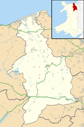
The county of Denbighshire is in north-east Wales, occupying the Vale of Clwyd and the uplands to the west, east and south. There are 168 Scheduled Monuments in the county. The oldest is from 225,000 years ago, the oldest inhabited site in Wales. A further 3 limestone cave systems also have Paleolithic deposits. Three chambered tombs date to the Neolithic. The moorlands in particular are home to many of the 100 Bronze Age and Iron Age, the vast majority of which are burial mounds. There are some 21 hill forts and other enclosure sites, and several stone circles. There are only 3 sites from the Roman period, and none dating to Early Medieval times. From the Medieval period itself on the other hand, there are 40 sites, including castles, town walls, chapels, crosses, domestic buildings, defensive buildings, bridges and monastic sites. There are 18 post-medieval sites, being a very diverse mix of site types and dates. Most notable is the World Heritage Site at Pontcysyllte Aqueduct. The modern county of Denbighshire bears only slight alignment with the historic county of the same name. The modern county includes parts of historic Merionethshire and Flintshire.
Scheduled Ancient Monuments (SAMs) have statutory protection. It is illegal to disturb the ground surface or any standing remains. The compilation of the list is undertaken by Cadw Welsh Historic Monuments, which is an executive agency of the National Assembly of Wales.[1] The list of scheduled monuments below is supplied by Cadw[2] with additional material from RCAHMW and Clwyd-Powys Archaeological Trust.
Scheduled Monuments in Denbighshire
| Image | Name | Site type | Community | Location | Details | Historic elisounty | Period | SAM No & Refs |
|---|---|---|---|---|---|---|---|---|
| Bontnewydd Cave | Cave | Cefnmeiriadog | 53°13′38″N 3°28′35″W / 53.2271°N 3.4763°W, SJ015710 |
Cave excavated in 1985, which found Neanderthal jaw and teeth remains dated to 225,000 years ago, along with stone tools. These are the oldest hominid remains in Wales. | Denbighshire | Prehistoric (palaeolithic) |
DE116 [3] | |
| Cefn Caves | Cave | Cefnmeiriadog | 53°13′22″N 3°28′07″W / 53.2227°N 3.4685°W, SJ020705 |
Network of caves first excavated in the 1830s, finding fragments of stone tools along with numerous animal bones over a wide period, probably accumulated in the caves by water action. | Denbighshire | Prehistoric (palaeolithic and later) |
DE115 [4] | |
 |
Cae Gwyn Cave | Cave | Tremeirchion | 53°14′29″N 3°22′20″W / 53.2414°N 3.3722°W, SJ085724 |
Cave with worked flint tools. Dated to 16,000BC. | Flintshire | Prehistoric (palaeolithic) |
FL070 [5] |
 |
Ffynnon Beuno Cave | Cave | Tremeirchion | 53°14′28″N 3°22′19″W / 53.241°N 3.3719°W, SJ085724 |
Limestone cave, where flint tools and animal bones have been found. | Flintshire | Prehistoric (palaeolithic) |
FL069 [6] |
| Branas-Uchaf Round Barrow | Chambered tomb | Llandrillo | 52°55′34″N 3°28′20″W / 52.926°N 3.4723°W, SJ011375 |
Chambered tomb with central chamber still in situ, but no capstone. | Merionethshire | Prehistoric (neolithic) |
ME070 [7] | |
| Tyddyn Bleiddyn Burial Chamber | Chambered long cairn | Cefnmeiriadog | 53°14′24″N 3°29′20″W / 53.2399°N 3.4889°W, SJ007724 |
Two cairns excavated in the mid-19th century. They found numerous crouched inhumations in two cists, with passageways. | Denbighshire | Prehistoric (neolithic) |
DE007 [8] | |
| Tan-y-Coed Burial Chamber | Chambered long cairn | Llandrillo | 52°56′44″N 3°25′08″W / 52.9455°N 3.4188°W, SJ047396 |
Merionethshire | Prehistoric (neolithic) |
ME048 [9] | ||
| Round Barrow 135m SE of Lodge Farm | Round barrow | Bodfari | 53°14′15″N 3°20′32″W / 53.2375°N 3.3423°W, SJ105720 |
Flintshire | Prehistoric |
FL034 [10] | ||
| Gribin Oernant Cairn | Round barrow | Bryneglwys | 53°00′44″N 3°13′41″W / 53.0122°N 3.2281°W, SJ177468 |
Denbighshire | Prehistoric |
DE271 [11] | ||
| Pant y Maen Round Barrow | Round barrow | Bryneglwys | 53°01′15″N 3°15′21″W / 53.0207°N 3.2558°W, SJ158477 |
Denbighshire | Prehistoric |
DE034 [12] | ||
| Rhos Lydan Round Barrows | Round barrow | Bryneglwys | 53°02′12″N 3°15′07″W / 53.0367°N 3.2519°W, SJ161495 |
Denbighshire | Prehistoric |
DE035 [13] | ||
| Ty Mawr Round Barrows | Round barrow | Bryneglwys | 53°01′29″N 3°15′11″W / 53.0248°N 3.2531°W, SJ160482 |
Denbighshire | Prehistoric |
DE033 [14] | ||
| Bedd Emlyn | Round barrow | Clocaenog | 53°04′05″N 3°24′56″W / 53.068°N 3.4155°W, SJ052532 |
Denbighshire | Prehistoric |
DE201 [15] | ||
| Bryn Beddau Round Barrows | Round barrow | Clocaenog | 53°03′53″N 3°25′13″W / 53.0648°N 3.4203°W, SJ049528 |
Group of Bronze Age barrows in Clocaenog Forest discovered when forest roads were built in the 1960s. One of the barrows may be a stone circle. The site includes 'Bedd Emlyn' which had an early medieval ogham stone, removed in 1813 and now in the National Museum of Wales.[16] | Denbighshire | Prehistoric (bronze age) |
DE040 [17] | |
| Bryn Beddau Stone Circle | Stone circle | Clocaenog | 53°03′43″N 3°25′24″W / 53.0619°N 3.4232°W, SJ047525 |
Prehistoric stone circle of at least 19 stones, within Clocaenog Forest, in a heather-covered clearing. | Denbighshire | Prehistoric |
DE245 [18] | |
| Maen Llwyd Standing Stone | Standing stone | Clocaenog | 53°03′36″N 3°25′19″W / 53.0601°N 3.4219°W, SJ048523 |
Massive stone, 3.4m long, now lying down. It is within Clocaenog Forest. | Denbighshire | Prehistoric |
DE255 [19] | |
| Plas Perthi Burial Mound | Round barrow | Clocaenog | 53°04′37″N 3°21′00″W / 53.0769°N 3.3499°W, SJ096541 |
Denbighshire | Prehistoric |
DE192 [20] | ||
| Rug Mound | Round barrow | Corwen | 52°59′02″N 3°24′27″W / 52.9839°N 3.4075°W, SJ056438 |
Merionethshire | Prehistoric |
ME019 [21] | ||
| Two Cairns North of Plasnewydd | Round cairn | Corwen | 52°57′42″N 3°17′41″W / 52.9616°N 3.2947°W, SJ131412 |
Denbighshire | Prehistoric |
DE272 [22] | ||
| Wilderness Round Barrows | Round barrow | Corwen, (also Llangollen), (also Llansantffraid Glyn Ceiriog), (see also Wrexham) | 52°57′14″N 3°13′47″W / 52.9539°N 3.2298°W, SJ174403 |
Denbighshire | Prehistoric |
DE092 [23] | ||
| Round Barrow 400m SE of Tai Marian | Round barrow | Cwm | 53°17′01″N 3°23′15″W / 53.2836°N 3.3876°W, SJ075771 |
Flintshire | Prehistoric |
FL041 [24] | ||
| Three Round Barrows in Cwm Wood | Round barrow | Cwm | 53°16′43″N 3°23′12″W / 53.2785°N 3.3866°W, SJ076766 |
Flintshire | Prehistoric |
FL192 [25] | ||
| Capel Hiraethog Earth Circles | Ring cairn | Cyffylliog | 53°04′48″N 3°26′25″W / 53.0801°N 3.4402°W, SJ036546 |
Denbighshire | Prehistoric |
DE043 [26] | ||
| Capel Hiraethog Round Barrow | Round barrow | Cyffylliog | 53°04′44″N 3°26′44″W / 53.0789°N 3.4455°W, SJ032544 |
Denbighshire | Prehistoric |
DE042 [27] | ||
| Moel yr Henfaes Cairn Cemetery | Round cairn | Cynwyd | 52°56′34″N 3°23′22″W / 52.9428°N 3.3894°W, SJ067392 |
Merionethshire | Prehistoric |
DE301 [28] | ||
| Moel yr Henfaes Ring Cairn | Ring cairn | Cynwyd | 52°56′16″N 3°22′41″W / 52.9377°N 3.3781°W, SJ074387 |
Merionethshire | Prehistoric |
DE299 [29] | ||
| Nant Croes-y-wernen Stone Circle | Stone circle | Cynwyd | 52°56′29″N 3°20′37″W / 52.9414°N 3.3435°W, SJ098390 |
Merionethshire | Prehistoric |
DE300 [30] | ||
| Garw Fynydd Cairn | Platform Cairn | Derwen | 53°02′52″N 3°24′48″W / 53.0479°N 3.4134°W, SJ053510 |
Denbighshire | Prehistoric |
DE274 [31] | ||
| Coed Plas Round Barrow | Round barrow | Henllan | 53°12′24″N 3°26′59″W / 53.2067°N 3.4498°W, SJ032687 |
Denbighshire | Prehistoric |
DE050 [32] | ||
| Old Foxhall Round Barrow | Round barrow | Henllan | 53°11′41″N 3°26′53″W / 53.1948°N 3.4481°W, SJ033673 |
Denbighshire | Prehistoric |
DE052 [33] | ||
| Plas Heaton Round Barrow | Round barrow | Henllan | 53°12′20″N 3°26′59″W / 53.2055°N 3.4496°W, SJ032685 |
Denbighshire | Prehistoric |
DE049 [34] | ||
| Plas-Meifod Round Barrow | Round barrow | Henllan | 53°12′07″N 3°27′26″W / 53.2019°N 3.4573°W, SJ027681 |
Denbighshire | Prehistoric |
DE051 [35] | ||
| Moel y Plas Round Barrow | Round barrow | Llanarmon-yn-Ial | 53°05′23″N 3°14′25″W / 53.0897°N 3.2404°W, SJ170554 |
Denbighshire | Prehistoric |
DE062 [36] | ||
| Tyn-y-Mynydd Round Barrow | Round barrow | Llanarmon-yn-Ial | 53°05′36″N 3°14′37″W / 53.0934°N 3.2435°W, SJ168558 |
Denbighshire | Prehistoric |
DE061 [37] | ||
| Moel Eithinen Round Barrow | Round barrow | Llanbedr Dyffryn Clwyd | 53°07′21″N 3°15′34″W / 53.1224°N 3.2595°W, SJ158591 |
Denbighshire | Prehistoric |
DE280 [38] | ||
| Moel Gyw Round Barrow | Round barrow | Llanbedr Dyffryn Clwyd | 53°06′31″N 3°14′21″W / 53.1086°N 3.2391°W, SJ171575 |
Denbighshire | Prehistoric |
DE063 [39] | ||
| Mynydd Cricor Barrow | Round barrow | Llanbedr Dyffryn Clwyd | 53°02′37″N 3°16′26″W / 53.0435°N 3.2738°W, SJ146503 |
Denbighshire | Prehistoric |
DE266 [40] | ||
| Abersychnant Cairn | Round barrow | Llandegla | 53°02′19″N 3°08′35″W / 53.0385°N 3.143°W, SJ234496 |
Denbighshire | Prehistoric |
DE264 [41] | ||
| Cas-Gan-Ditw Round Barrow | Round barrow | Llandegla | 53°03′49″N 3°08′49″W / 53.0637°N 3.1469°W, SJ232524 |
Denbighshire | Prehistoric |
DE169 [42] | ||
| Cefn y Cist Cairn | Round barrow | Llandegla | 53°01′47″N 3°08′12″W / 53.0297°N 3.1366°W, SJ238486 |
Denbighshire | Prehistoric |
DE269 [43] | ||
| Cefn y Gader Round Barrows | Round barrow | Llandegla, (also Penycae), (also Minera), (see also Wrexham) | 53°02′21″N 3°08′18″W / 53.0393°N 3.1384°W, SJ237497 |
Denbighshire | Prehistoric |
DE070 [44] | ||
| Craig-y-Forwyn Cairn | Round cairn | Llandegla | 53°01′29″N 3°08′20″W / 53.0246°N 3.139°W, SJ236480 |
Denbighshire | Prehistoric |
DE267 [45] | ||
| Cryn-y-Brain Round Barrow | Round barrow | Llandegla | 53°01′49″N 3°09′08″W / 53.0303°N 3.1523°W, SJ228487 |
Denbighshire | Prehistoric |
DE270 [46] | ||
| Cyrn y Brain Round Barrows | Round barrow | Llandegla | 53°02′18″N 3°10′29″W / 53.0384°N 3.1747°W, SJ213496 |
Denbighshire | Prehistoric |
DE065 [47] | ||
| Llyn Cyfnwy Round Barrow | Round barrow | Llandegla | 53°05′03″N 3°10′28″W / 53.0842°N 3.1745°W, SJ214547 |
Denbighshire | Prehistoric |
DE064 [48] | ||
| Maes Maelor Round Barrow | Round barrow | Llandegla | 53°03′55″N 3°08′48″W / 53.0653°N 3.1466°W, SJ232526 |
Denbighshire | Prehistoric |
DE056 [49] | ||
| Rhos-Ddigre Caves | Cave | Llandegla | 53°04′25″N 3°12′49″W / 53.0737°N 3.2135°W, SJ187536 |
Group of 5 caves with Bronze Age burials | Denbighshire | Prehistoric (bronze age) |
DE119 [50] | |
| Blaen Llynor Round Cairn | Round cairn | Llandrillo | 52°55′13″N 3°21′44″W / 52.9203°N 3.3622°W, SJ085367 |
Merionethshire | Prehistoric |
DE302 [51] | ||
| Cader Bronwen Round Barrow | Round barrow | Llandrillo | 52°54′05″N 3°22′22″W / 52.9014°N 3.3729°W, SJ077346 |
Denbighshire | Prehistoric |
DE060 [52] | ||
| Cairns, Settlements & Field Systems of Prehistoric & Medieval date at Pennant above Nant Esgeiriau | Ring cairn | Llandrillo | 52°53′18″N 3°25′03″W / 52.8884°N 3.4175°W, SJ047332 |
Merionethshire | Prehistoric |
ME146 [53] | ||
| Carnedd y Ci Barrow | Round cairn | Llandrillo | 52°53′40″N 3°24′18″W / 52.8945°N 3.405°W, SJ055339 |
Denbighshire | Prehistoric |
DE260 [54] | ||
| Cefn Penagored Cairn and Ring Cairn | Kerb cairn | Llandrillo | 52°53′29″N 3°25′47″W / 52.8914°N 3.4298°W, SJ038336 |
Denbighshire | Prehistoric |
DE257 [55] | ||
| Cefn Penagored Ridge Cairns | Kerb cairn | Llandrillo | 52°53′28″N 3°25′36″W / 52.891°N 3.4267°W, SJ041335 |
Denbighshire | Prehistoric |
DE256 [56] | ||
| Moel Sych Round Barrow | Round barrow | Llandrillo, (also Llanrhaeadr-ym-Mochnant), (see also Powys) | 52°52′34″N 3°23′19″W / 52.8761°N 3.3887°W, SJ066318 |
Denbighshire | Prehistoric |
DE067 [57] | ||
| Moel Ty-Uchaf Circles | Stone circle | Llandrillo | 52°55′24″N 3°24′18″W / 52.9232°N 3.4051°W, SJ056371 |
A circle of 43 stones, probably representing the kerbs of a burial mound. A central hollow could be a robbed-out grave. | Merionethshire | Prehistoric |
ME013 [58] | |
| Nant Esgeiriau Cairn | Round cairn | Llandrillo | 52°53′08″N 3°25′20″W / 52.8856°N 3.4221°W, SJ044329 |
Denbighshire | Prehistoric |
DE259 [59] | ||
| Nant Gwyn Round Cairns | Round cairn | Llandrillo | 52°55′24″N 3°22′25″W / 52.9234°N 3.3737°W, SJ077371 |
Merionethshire | Prehistoric |
DE305 [60] | ||
| Pennant Cairns | Round barrow | Llandrillo | 52°53′20″N 3°25′27″W / 52.889°N 3.4241°W, SJ042333 |
Denbighshire | Prehistoric |
DE258 [61] | ||
| Ring Cairn E of Ffridd Camen | Ring cairn | Llandrillo | 52°53′57″N 3°25′03″W / 52.8992°N 3.4175°W, SJ047344 |
Merionethshire | Prehistoric |
ME147 [62] | ||
| Two Ring Cairns West of Cwm Tywyll | Ring cairn | Llandrillo | 52°53′38″N 3°25′37″W / 52.8939°N 3.4269°W, SJ041338 |
Merionethshire | Prehistoric |
ME145 [63] | ||
| Tyfos Stone Circle | Stone circle | Llandrillo | 52°56′15″N 3°26′49″W / 52.9374°N 3.447°W, SJ028388 |
Thirteen recumbent stones define the kerb of a cairn | Merionethshire | Prehistoric (bronze age) |
ME024 [64] | |
| Tom Dongen Round Barrow | Round barrow | Llanelidan | 53°01′53″N 3°19′22″W / 53.0315°N 3.3229°W, SJ113490 |
Denbighshire | Prehistoric |
DE072 [65] | ||
| Cefn Coch Tumulus | Round barrow | Llanfair Dyffryn Clwyd | 53°06′08″N 3°17′02″W / 53.1022°N 3.2839°W, SJ141568 |
Denbighshire | Prehistoric |
DE265 [66] | ||
| Moel Llech Round Barrow | Round barrow | Llanfair Dyffryn Clwyd | 53°05′37″N 3°14′38″W / 53.0935°N 3.2438°W, SJ168558 |
Denbighshire | Prehistoric |
DE108 [67] | ||
| Ffynnon-Las Wood Round Barrow | Round barrow | Llangollen | 52°57′37″N 3°11′56″W / 52.9603°N 3.1988°W, SJ195409 |
Denbighshire | Prehistoric |
DE091 [68] | ||
| Circular Platforms North West of Hen Ddinbych | Platform Cairn | Llanrhaeadr-yng-Nghinmeirch | 53°05′48″N 3°30′37″W / 53.0967°N 3.5102°W, SH989565 |
Denbighshire | Prehistoric |
DE087 [69] | ||
| Twr yr Hill Round Barrow | Round barrow | Llanrhaeadr-yng-Nghinmeirch | 53°06′42″N 3°28′44″W / 53.1117°N 3.479°W, SJ010581 |
Denbighshire | Prehistoric |
DE088 [70] | ||
| Craig Arthur Kerb Cairn | Kerb cairn | Llantysilio | 53°00′55″N 3°09′33″W / 53.0153°N 3.1593°W, SJ223470 |
Denbighshire | Prehistoric |
DE262 [71] | ||
| Creigiau Eglwyseg Cairn | Round cairn | Llantysilio | 52°59′31″N 3°09′39″W / 52.992°N 3.1608°W, SJ221444 |
Denbighshire | Prehistoric |
DE261 [72] | ||
| Creigiau Eglwyseg Round Barrow | Round barrow | Llantysilio | 52°59′56″N 3°08′59″W / 52.9988°N 3.1496°W, SJ229452 |
Denbighshire | Prehistoric |
DE079 [73] | ||
| Creigiau Eglwyseg Round Barrows & Earth Circle | Round barrow | Llantysilio | 52°59′46″N 3°09′35″W / 52.9962°N 3.1598°W, SJ222449 |
Denbighshire | Prehistoric |
DE081 [74] | ||
| Creigiau Eglwyseg Stone Circle | Stone circle | Llantysilio | 52°59′52″N 3°09′05″W / 52.9979°N 3.1515°W, SJ228451 |
Possible stone circle, or kerbs of a cairn. | Denbighshire | Prehistoric |
DE080 [75] | |
| Eglwyseg Mountain Round Barrow | Round barrow | Llantysilio, (also Penycae), (see also Wrexham) | 53°00′31″N 3°08′49″W / 53.0086°N 3.147°W, SJ231463 |
Denbighshire | Prehistoric |
DE066 [76] | ||
 |
Eliseg's Pillar |
Round barrow with inscribed pillar | Llantysilio | 52°59′32″N 3°11′21″W / 52.9921°N 3.1893°W, SJ202445 |
Erected by Cyngen ap Cadell (died 855), king of Powys in honour of his great-grandfather Elisedd ap Gwylog. The form Eliseg found on the pillar is thought to be a mistake by the carver of the inscription. The pillar stands on a Bronze age burial mound. | Denbighshire | Prehistoric |
DE015 [77] |
| Moel Gamelin Round Barrow | Round barrow | Llantysilio | 53°00′35″N 3°13′45″W / 53.0096°N 3.2291°W, SJ176465 |
Denbighshire | Prehistoric |
DE068 [78] | ||
| Rhewl Round Barrows | Round barrow | Llanynys | 53°07′58″N 3°19′34″W / 53.1329°N 3.3261°W, SJ113603 |
Denbighshire | Prehistoric |
DE167 [79] | ||
| Bwlch-Du Round Barrow | Round barrow | Nantglyn | 53°06′36″N 3°30′41″W / 53.11°N 3.5114°W, SH989580 |
Denbighshire | Prehistoric |
DE085 [80] | ||
| Gorsedd Bran Round Barrows | Platform Cairn | Nantglyn | 53°07′47″N 3°32′06″W / 53.1296°N 3.5351°W, SH973602 |
Denbighshire | Prehistoric |
DE168 [81] | ||
| Round Barrow at Coed Bell, Gronant | Round barrow | Prestatyn | 53°20′06″N 3°22′18″W / 53.3351°N 3.3718°W, SJ087828 |
Flintshire | Prehistoric |
FL188 [82] | ||
| Round Barrow West of Ty Draw | Round barrow | Prestatyn | 53°19′08″N 3°23′51″W / 53.319°N 3.3976°W, SJ069811 |
Flintshire | Prehistoric |
FL112 [83] | ||
| Castle Farm Round Barrow | Round barrow | Ruthin | 53°06′45″N 3°18′27″W / 53.1126°N 3.3075°W, SJ125580 |
Denbighshire | Prehistoric |
DE105 [84] | ||
| Criafol Round Barrow | Round barrow | Tremeirchion | 53°16′27″N 3°21′41″W / 53.2742°N 3.3614°W, SJ093761 |
Flintshire | Prehistoric |
FL170 [85] | ||
| Round Barrow 270m NW of Traveller's Inn | Round barrow | Tremeirchion | 53°16′22″N 3°20′06″W / 53.2727°N 3.335°W, SJ110759 |
Flintshire | Prehistoric |
FL047 [86] | ||
| Round Barrow 800m NE of Criafol Farm | Round barrow | Tremeirchion | 53°16′47″N 3°20′57″W / 53.2797°N 3.3492°W, SJ101767 |
Flintshire | Prehistoric |
FL048 [87] | ||
| Two Round Barrows on Moel Maen Efa | Round barrow | Tremeirchion | 53°15′30″N 3°22′13″W / 53.2583°N 3.3703°W, SJ086743 |
Flintshire | Prehistoric |
FL049 [88] | ||
| Coed Clwyd Cairns | Round barrow | Waen | 53°08′33″N 3°15′27″W / 53.1424°N 3.2576°W, SJ159613 |
Denbighshire | Prehistoric |
DE248 [89] | ||
| Dinas Melin-y-Wig | Hillfort | Betws Gwerfil Goch | 53°01′52″N 3°25′09″W / 53.0312°N 3.4193°W, SJ049491 |
Merionethshire | Prehistoric |
ME014 [90] | ||
| Mynydd Rhyd Ddu Enclosure | Hillfort | Betws Gwerfil Goch | 53°01′07″N 3°24′37″W / 53.0187°N 3.4104°W, SJ054477 |
Denbighshire | Prehistoric |
DE252 [91] | ||
| Moel y Gaer | Hillfort | Bodfari | 53°13′35″N 3°21′24″W / 53.2265°N 3.3568°W, SJ095707 |
Flintshire | Prehistoric |
FL073 [92] | ||
 |
Moel y Gaer, Cefn | Hillfort | Bryneglwys | 53°00′29″N 3°14′34″W / 53.0081°N 3.2428°W, SJ167463 |
Denbighshire | Prehistoric |
DE126 [93] | |
 |
Bedd-y-Cawr Hillfort | Hillfort | Cefnmeiriadog | 53°14′11″N 3°28′48″W / 53.2364°N 3.4799°W, SJ013720 |
Hillfort on natural inland promontory with ditch and bank and an area of 0.8 hectares (2.0 acres) | Denbighshire | Prehistoric |
DE037 [94] |
| Pont Petryal Caerau Circles | Enclosure | Clocaenog | 53°03′29″N 3°25′44″W / 53.0581°N 3.429°W, SJ043521 |
Denbighshire | Prehistoric |
DE041 [95] | ||
| Bwrdd y Tri Arglwydd Boundary Stone | Boundary stone | Corwen | 53°00′40″N 3°20′11″W / 53.011°N 3.3364°W, SJ104468 |
Possible remnant of a cromlech, or a medieval boundary stones. It is at the junction of four parishes. | Merionethshire | Prehistoric |
ME025 [96] | |
| Caer Drewen Camp | Hillfort | Corwen | 52°59′21″N 3°21′36″W / 52.9892°N 3.3601°W, SJ087444 |
Merionethshire | Prehistoric |
ME012 [97] | ||
| Moel Fodig Camp | Hillfort | Corwen | 53°00′03″N 3°20′54″W / 53.0007°N 3.3482°W, SJ096456 |
Merionethshire | Prehistoric |
ME051 [98] | ||
| Y Garth Camp | Enclosure | Cyffylliog | 53°07′03″N 3°22′30″W / 53.1174°N 3.3751°W, SJ080586 |
Denbighshire | Prehistoric |
DE103 [99] | ||
| Gwerclas Mound | Mound | Cynwyd | 52°58′06″N 3°24′36″W / 52.9682°N 3.4101°W, SJ053421 |
Merionethshire | Prehistoric |
ME069 [100] | ||
| Y Gaerwen Enclosure, Llangar | Enclosure | Cynwyd | 52°57′17″N 3°26′59″W / 52.9547°N 3.4498°W, SJ027406 |
Merionethshire | Prehistoric |
ME091 [101] | ||
| Moel Hiraddug Hillfort | Hillfort | Dyserth | 53°17′37″N 3°24′21″W / 53.2937°N 3.4057°W, SJ064783 |
Flintshire | Prehistoric |
FL012 [102] | ||
| Craig Adwywynt Camp | Hillfort | Efenechtyd | 53°04′45″N 3°18′46″W / 53.0793°N 3.3129°W, SJ121543 |
Denbighshire | Prehistoric |
DE073 [103] | ||
| Pen-y-Gaer Camp | Hillfort | Efenechtyd | 53°05′00″N 3°20′11″W / 53.0832°N 3.3364°W, SJ105548 |
Denbighshire | Prehistoric |
DE045 [104] | ||
| Moel Fenlli Camp | Hillfort | Llanbedr Dyffryn Clwyd | 53°07′53″N 3°15′08″W / 53.1314°N 3.2523°W, SJ163600 |
Denbighshire | Prehistoric |
DE009 [105] | ||
 |
Moel-y-Gaer Camp | Hillfort | Llanbedr Dyffryn Clwyd | 53°08′46″N 3°16′27″W / 53.146°N 3.2742°W, SJ148617 |
An oval iron age hillfort overlooking the Vale of Clwyd. | Denbighshire | Prehistoric |
DE010 [106] |
| Craig yr Uchain | Enclosure | Llandrillo | 52°55′04″N 3°27′08″W / 52.9179°N 3.4523°W, SJ024366 |
Denbighshire | Prehistoric |
DE230 [107] | ||
| Platform Settlement by Clochnant E of Cadwst | Unenclosed hut circle | Llandrillo | 52°54′21″N 3°25′07″W / 52.9058°N 3.4186°W, SJ046352 |
Merionethshire | Prehistoric |
ME148 [108] | ||
| Moel Arthur Camp | Hillfort | Llandyrnog, (also Nannerch), (see also Flintshire) | 53°11′05″N 3°16′50″W / 53.1846°N 3.2806°W, SJ145660 |
Flintshire | Prehistoric |
FL010 [109] | ||
| Pen-y-Cloddiau Camp | Hillfort | Llandyrnog, (also Ysceifiog), (see also Flintshire) | 53°11′55″N 3°18′19″W / 53.1986°N 3.3054°W, SJ128676 |
Flintshire | Prehistoric |
FL009 [110] | ||
| Prestatyn Roman Site | Settlement | Prestatyn | 53°19′31″N 3°24′37″W / 53.3253°N 3.4104°W, SJ061818 |
Flintshire | Roman |
FL094 [111] | ||
| Blaen-y-Cwm Inscribed Stone (Now in Llandrillo Church) | Inscribed stone | Llandrillo | 52°55′20″N 3°26′16″W / 52.9223°N 3.4379°W, SJ034370 |
Merionethshire | Roman |
ME066 [112] | ||
| Plas-newydd Romano-British temple cropmark | Temple | Llanfair Dyffryn Clwyd | 53°05′31″N 3°17′24″W / 53.0919°N 3.2901°W, SJ137557 |
Denbighshire | Roman |
DE289 [113] | ||
| Ffynnon Fair (Well), Cefn | Holy Well | Cefnmeiriadog | 53°13′40″N 3°27′21″W / 53.2278°N 3.4557°W, SJ029710 |
Denbighshire | Medieval |
DE038 [114] | ||
| Corwen Churchyard Cross | Cross | Corwen | 52°58′48″N 3°22′25″W / 52.98°N 3.3736°W, SJ079433 |
Merionethshire | Medieval |
ME052 [115] | ||
 |
Owain Glyndwr's Mount | Motte | Corwen | 52°58′41″N 3°18′17″W / 52.9781°N 3.3046°W, SJ125431 |
Merionethshire | Medieval |
ME017 [116] | |
| Coed Llynor Long Hut | Deserted Rural Settlement | Cynwyd | 52°55′27″N 3°23′06″W / 52.9242°N 3.3851°W, SJ069372 |
Merionethshire | Medieval |
DE304 [117] | ||
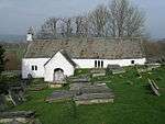 |
Llangar Old Parish Church |
Church | Cynwyd | 52°58′16″N 3°23′45″W / 52.9712°N 3.3959°W, SJ063424 |
Merionethshire | Medieval |
ME093 [118] | |
| Coed Clattwn Moated Site | Moated Site | Denbigh | 53°12′27″N 3°25′52″W / 53.2076°N 3.431°W, SJ045687 |
Denbighshire | Medieval |
DE234 [119] | ||
 |
Denbigh Castle and Medieval Town |
Castle | Denbigh | 53°10′50″N 3°25′14″W / 53.1806°N 3.4206°W, SJ051657 |
Denbighshire | Medieval |
DE156 [120] | |
 |
Denbigh Friary |
Friary | Denbigh | 53°11′16″N 3°24′33″W / 53.1878°N 3.4091°W, SJ059665 |
Denbighshire | Medieval |
DE023 [121] | |
 |
Denbigh Medieval Town (North - Eastern Corner) | Town | Denbigh | 53°10′54″N 3°25′09″W / 53.1816°N 3.4191°W, SJ052658 |
Denbighshire | Medieval |
DE225 [122] | |
 |
Denbigh Town Walls |
Town defences | Denbigh | 53°10′51″N 3°25′09″W / 53.1808°N 3.4191°W, SJ052657 |
Denbighshire | Medieval |
DE002 [123] | |
| Llys Gwenllian Mound & Bailey | Motte & Bailey | Denbigh | 53°10′06″N 3°24′47″W / 53.1682°N 3.4131°W, SJ056643 |
Denbighshire | Medieval |
DE019 [124] | ||
 |
Denbigh, St Hilary's Chapel |
Tower | Denbigh | 53°10′54″N 3°25′11″W / 53.1818°N 3.4198°W, SJ052659 |
Denbighshire | Medieval |
DE005 [125] | |
| Derwen Churchyard Cross |
Cross | Derwen | 53°02′45″N 3°23′18″W / 53.0457°N 3.3882°W, SJ070507 |
Denbighshire | Medieval |
DE162 [126] | ||
| Dyserth Castle | Castle | Dyserth | 53°18′28″N 3°24′40″W / 53.3079°N 3.4111°W, SJ060799 |
Flintshire | Medieval |
FL130 [127] | ||
| Siamber-Wen Medieval House | House (domestic) | Dyserth | 53°18′21″N 3°24′36″W / 53.3057°N 3.4101°W, SJ061796 |
Flintshire | Medieval |
FL063 [128] | ||
| Old Foxhall Earth Circle | Enclosure | Henllan | 53°11′42″N 3°26′47″W / 53.195°N 3.4465°W, SJ034674 |
Denbighshire | Medieval |
DE053 [129] | ||
| Pysgodlan Moated Site | Moated Site | Henllan | 53°12′44″N 3°26′22″W / 53.2122°N 3.4394°W, SJ039693 |
Denbighshire | Medieval |
DE200 [130] | ||
| Tomen y Faerdre Castle Mound | Motte | Llanarmon-yn-Ial | 53°05′47″N 3°12′22″W / 53.0964°N 3.2062°W, SJ193561 |
Denbighshire | Medieval |
DE006 [131] | ||
 |
Churchyard Cross, St Meugan's Church | Cross | Llanbedr Dyffryn Clwyd | 53°06′36″N 3°17′10″W / 53.11°N 3.2861°W, SJ140577 |
Denbighshire | Medieval |
DE188 [132] | |
| Tomen y Rhodwydd (Castell yr Adwy) Mound and Bailey Castle | Motte & Bailey | Llandegla | 53°03′19″N 3°13′46″W / 53.0553°N 3.2294°W, SJ176516 |
Denbighshire | Medieval |
DE018 [133] | ||
| Cwm Tywyll House Platforms | House platform | Llandrillo | 52°53′40″N 3°25′09″W / 52.8944°N 3.4192°W, SJ046339 |
Denbighshire | Medieval |
DE249 [134] | ||
| Ffridd Camen Hafodydd | Platform house | Llandrillo | 52°54′01″N 3°25′21″W / 52.9003°N 3.4225°W, SJ044345 |
Denbighshire | Medieval |
DE250 [135] | ||
| Ffridd Camen Long Hut | Rectangular hut | Llandrillo | 52°54′07″N 3°25′17″W / 52.9019°N 3.4213°W, SJ044347 |
Denbighshire | Medieval |
DE251 [136] | ||
| Ffridd yr Eglwys Deserted Rural Settlement | Rectangular hut | Llandrillo | 52°53′24″N 3°26′10″W / 52.8899°N 3.4361°W, SJ034334 |
Denbighshire | Medieval |
DE254 [137] | ||
| Gwern Wynodl Hafod | Platform house | Llandrillo | 52°54′29″N 3°25′20″W / 52.908°N 3.4223°W, SJ044354 |
Denbighshire | Medieval |
DE247 [138] | ||
| Nant Gwyn Long Hut | Deserted Rural Settlement | Llandrillo | 52°55′34″N 3°23′14″W / 52.9261°N 3.3872°W, SJ068374 |
Merionethshire | Medieval |
DE306 [139] | ||
| Coed Henblas Moated Site | Moated Site | Llanfair Dyffryn Clwyd | 53°05′13″N 3°16′29″W / 53.087°N 3.2748°W, SJ147551 |
Denbighshire | Medieval |
DE232 [140] | ||
| Castell Dinas Bran | Castle | Llangollen | 52°58′44″N 3°09′30″W / 52.979°N 3.1584°W, SJ223430 |
Denbighshire | Medieval |
DE021 [141] | ||
 |
Llangollen Bridge | Bridge | Llangollen | 52°58′16″N 3°10′13″W / 52.971°N 3.1702°W, SJ215421 |
Denbighshire | Medieval |
DE026 [142] | |
| Hen Ddinbych Circular Platforms | Enclosure | Llanrhaeadr-yng-Nghinmeirch | 53°05′42″N 3°30′33″W / 53.0949°N 3.5093°W, SH990563 |
Denbighshire | Medieval |
DE086 [143] | ||
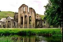 |
Valle Crucis Abbey |
Abbey | Llantysilio | 52°59′20″N 3°11′12″W / 52.9888°N 3.1867°W, SJ204441 |
Denbighshire | Medieval |
DE003 [144] | |
| Prestatyn Castle | Castle | Prestatyn | 53°20′18″N 3°23′39″W / 53.3383°N 3.3943°W, SJ072833 |
An earth mound south of Prestatyn railway station. | Flintshire | Medieval |
FL024 [145] | |
| Criccin Cross | Cross shaft | Rhuddlan | 53°16′57″N 3°26′23″W / 53.2826°N 3.4396°W, SJ041771 |
Flintshire | Medieval |
FL102 [146] | ||
| Part of site of Rhuddlan Norman Borough | Town | Rhuddlan | 53°17′18″N 3°27′42″W / 53.2882°N 3.4617°W, SJ026778 |
Flintshire | Medieval |
FL129 [147] | ||
| Rhuddlan Bridge | Bridge | Rhuddlan | 53°17′24″N 3°28′08″W / 53.2899°N 3.4689°W, SJ021779 |
Flintshire | Medieval |
FL018 [148] | ||
 |
Rhuddlan Castle |
Castle | Rhuddlan | 53°17′21″N 3°27′54″W / 53.2891°N 3.465°W, SJ024779 |
Flintshire | Medieval |
FL004 [149] | |
| Rhuddlan Town Banks | Town defences | Rhuddlan | 53°17′33″N 3°28′05″W / 53.2925°N 3.468°W, SJ022782 |
Flintshire | Medieval |
FL068 [150] | ||
| Twthill, Rhuddlan |
Motte & Bailey | Rhuddlan | 53°17′14″N 3°27′43″W / 53.2871°N 3.4619°W, SJ026776 |
Flintshire | Medieval |
FL015 [151] | ||
| Ffynogion Moated Site | Moated Site | Ruthin | 53°05′45″N 3°18′12″W / 53.0958°N 3.3032°W, SJ128561 |
Denbighshire | Medieval |
DE074 [152] | ||
 |
Ruthin Castle | Castle | Ruthin | 53°06′45″N 3°18′42″W / 53.1124°N 3.3116°W, SJ123580 |
Denbighshire | Medieval |
DE022 [153] | |
| Deeside Slateworks | Water Power System | Corwen | 52°58′07″N 3°16′08″W / 52.9686°N 3.269°W, SJ148420 |
Denbighshire | Post-Medieval/Modern |
DE246 [154] | ||
| Pont Carrog | Bridge | Corwen | 52°59′01″N 3°19′09″W / 52.9835°N 3.3192°W, SJ115437 |
Merionethshire | Post-Medieval/Modern |
ME029 [155] | ||
| Rhug ornamental wrought iron gates | Gate | Corwen | 52°58′57″N 3°24′35″W / 52.9824°N 3.4097°W, SJ054437 |
Merionethshire | Post-Medieval/Modern |
ME047 [156] | ||
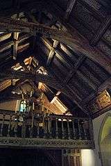 |
Rug Chapel |
Chapel | Corwen | 52°59′03″N 3°23′39″W / 52.9842°N 3.3942°W, SJ064438 |
Merionethshire | Post-Medieval/Modern |
ME089 [157] | |
| Pont Dyfrdwy | Bridge | Cynwyd | 52°57′37″N 3°24′41″W / 52.9602°N 3.4114°W, SJ052412 |
Merionethshire | Post-Medieval/Modern |
ME033 [158] | ||
| Civil War Earthworks | Siegeworks | Denbigh | 53°10′55″N 3°25′00″W / 53.182°N 3.4168°W, SJ054659 |
Denbighshire | Post-Medieval/Modern |
DE028 [159] | ||
 |
Leicester's Church, Denbigh |
Church | Denbigh | 53°10′56″N 3°25′08″W / 53.1822°N 3.419°W, SJ053659 |
The only large-scale church building project in Elizabethan England or Wales. Built, but left unfinished, by Robert Dudley, 1st Earl of Leicester, it now stands as a ruin in the centre of Denbigh. | Denbighshire | Post-Medieval/Modern |
DE044 [160] |
| Clive Engine House, Meliden | Engine house | Dyserth | 53°18′31″N 3°25′04″W / 53.3085°N 3.4179°W, SJ056799 |
Built in 1862, to house a pump for the Talargoch lead mine. | Flintshire | Post-Medieval/Modern |
FL136 [161] | |
| New Foxhall Dovecot | Dovecote | Henllan | 53°11′44″N 3°27′11″W / 53.1955°N 3.4531°W, SJ030674 |
Denbighshire | Post-Medieval/Modern |
DE055 [162] | ||
| New Foxhall House | House (domestic) | Henllan | 53°11′45″N 3°27′13″W / 53.1958°N 3.4537°W, SJ029675 |
Denbighshire | Post-Medieval/Modern |
DE054 [163] | ||
| Pont Cilan | Bridge | Llandrillo | 52°55′32″N 3°27′27″W / 52.9256°N 3.4575°W, SJ021374 |
Merionethshire | Post-Medieval/Modern |
ME032 [164] | ||
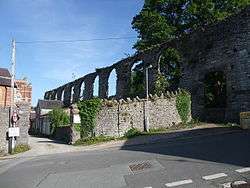
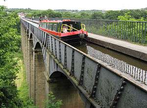 |
Pontcysyllte Aqueduct and Canal |
Aqueduct | Llangollen, (also Llangollen Rural), (also Chirk), (see also Wrexham) | 52°58′13″N 3°05′16″W / 52.9702°N 3.0878°W, SJ270419 |
Built in 1805, by Thomas Telford, this is the longest and highest aqueduct in Britain. It carries the Llangollen Canal over the River Dee. | Denbighshire | Post-Medieval/Modern |
DE175 [166] |
 |
Maen Huail | Stone | Ruthin | 53°06′52″N 3°18′39″W / 53.1144°N 3.3108°W, SJ123582 |
A square stone block in the centre of Ruthin, "On which tradition states, King Arthur beheaded Huail, brother of Gildas the historian". The stone is against the half-timbered wall of Exmewe Hall, on St. Peter's Square, facing the roundabout. | Denbighshire | Unknown |
DE030 [167] |
| Ruthin Churchyard Ornamental Wrought Iron Gates & Screen | Gate | Ruthin | 53°06′54″N 3°18′39″W / 53.1151°N 3.3108°W, SJ124583 |
Denbighshire | Post-Medieval/Modern |
DE159 [168] | ||
| Pont Dafydd (old) | Bridge | St Asaph | 53°15′49″N 3°26′06″W / 53.2636°N 3.4349°W, SJ043750 |
Flintshire | Post-Medieval/Modern |
FL027 [169] | ||
| St Asaph Bridge | Bridge | St Asaph | 53°15′23″N 3°26′51″W / 53.2564°N 3.4476°W, SJ035742 |
Flintshire | Post-Medieval/Modern |
FL026 [170] | ||
| Pennant Mines Winding Engine House & Chimney, Rhuallt | Engine house | Tremeirchion | 53°16′02″N 3°22′10″W / 53.2673°N 3.3694°W, SJ087753 |
Flintshire | Post-Medieval/Modern |
FL137 [171] | ||
| First World War Practice Trenches at Bodelwyddan Park | Practice trenches | Bodelwyddan | 53°15′28″N 3°30′00″W / 53.2577°N 3.4999°W, SJ000744 |
Flintshire | Post-Medieval/Modern |
FL186 [172] | ||

See also
- List of Cadw properties
- List of castles in Wales
- List of hill forts in Wales
- Historic houses in Wales
- List of monastic houses in Wales
- List of museums in Wales
- List of Roman villas in Wales
- Prehistoric Wales
References
- Coflein is the online database of RCAHMW: Royal Commission on the Ancient and Historical Monuments of Wales, CPAT is the Clwyd-Powys Archaeological Trust, Cadw is the Welsh Historic Monuments Agency
- ↑ Cadw: Ancient Monuments and Scheduling. Accessed 25 April 2013
- ↑ Cadw will send their list as a spreadsheet, or other electronic formats, on request, as indicated at www.whatdotheyknow.com. This list uses information dated May 2012
- ↑ coflein NPRN: 306687. CPAT PRN: 102132. Cadw SAM: DE116: Bont Newydd Cave
- ↑ coflein NPRN: 94801. CPAT PRN: 19306. Cadw SAM: DE115: Cefn Cave
- ↑ coflein NPRN: 306677. CPAT PRN: 102159. Cadw SAM: FL070: Cae Gwyn Cave
- ↑ coflein NPRN: 306678. CPAT PRN: 102158. Cadw SAM: FL069: Ffynnon Beuno Cave
- ↑ coflein NPRN: not yet identified. CPAT PRN: 100831. Cadw SAM: ME070: Branas-Uchaf Round Barrow
- ↑ coflein NPRN: 94726. CPAT PRN not yet identified. Cadw SAM: DE007: Tyddyn Bleiddyn Burial Chamber
- ↑ coflein NPRN: 306567. CPAT PRN not yet identified. Cadw SAM: ME048: Tan-y-Coed Burial Chamber
- ↑ coflein NPRN: not yet identified. CPAT PRN not yet identified. Cadw SAM: FL034: Round Barrow 135m SE of Lodge Farm
- ↑ coflein NPRN: not yet identified. CPAT PRN not yet identified. Cadw SAM: DE271: Gribin Oernant Cairn
- ↑ coflein NPRN: not yet identified. CPAT PRN not yet identified. Cadw SAM: DE034: Pant y Maen Round Barrow
- ↑ coflein NPRN: not yet identified. CPAT PRN not yet identified. Cadw SAM: DE035: Rhos Lydan Round Barrows
- ↑ coflein NPRN: not yet identified. CPAT PRN not yet identified. Cadw SAM: DE033: Ty Mawr Round Barrows
- ↑ coflein NPRN: not yet identified. CPAT PRN not yet identified. Cadw SAM: DE201: Bedd Emlyn
- ↑ Celtic Inscribed Stones Project, CLOCG/1
- ↑ coflein NPRN: 306621. CPAT PRN: 23170. Cadw SAM: DE040: Bryn Beddau Round Barrows
- ↑ coflein NPRN: not yet identified. CPAT PRN: 101697. Cadw SAM: DE245: Bryn Beddau Stone Circle
- ↑ coflein NPRN: not yet identified. CPAT PRN: 100741. Cadw SAM: DE255: Maen Llwyd Standing Stone
- ↑ coflein NPRN: not yet identified. CPAT PRN not yet identified. Cadw SAM: DE192: Plas Perthi Burial Mound
- ↑ coflein NPRN: not yet identified. CPAT PRN not yet identified. Cadw SAM: ME019: Rug Mound
- ↑ coflein NPRN: not yet identified. CPAT PRN not yet identified. Cadw SAM: DE272: Two Cairns North of Plasnewydd
- ↑ coflein NPRN: not yet identified. CPAT PRN not yet identified. Cadw SAM: DE092: Wilderness Round Barrows
- ↑ coflein NPRN: not yet identified. CPAT PRN not yet identified. Cadw SAM: FL041: Round Barrow 400m SE of Tai Marian
- ↑ coflein NPRN: not yet identified. CPAT PRN not yet identified. Cadw SAM: FL192: Three Round Barrows in Cwm Wood
- ↑ coflein NPRN: not yet identified. CPAT PRN not yet identified. Cadw SAM: DE043: Capel Hiraethog Earth Circles
- ↑ coflein NPRN: not yet identified. CPAT PRN not yet identified. Cadw SAM: DE042: Capel Hiraethog Round Barrow
- ↑ coflein NPRN: not yet identified. CPAT PRN not yet identified. Cadw SAM: DE301: Moel yr Henfaes Cairn Cemetery
- ↑ coflein NPRN: not yet identified. CPAT PRN not yet identified. Cadw SAM: DE299: Moel yr Henfaes Ring Cairn
- ↑ coflein NPRN: not yet identified. CPAT PRN not yet identified. Cadw SAM: DE300: Nant Croes-y-wernen Stone Circle
- ↑ coflein NPRN: not yet identified. CPAT PRN not yet identified. Cadw SAM: DE274: Garw Fynydd Cairn
- ↑ coflein NPRN: not yet identified. CPAT PRN not yet identified. Cadw SAM: DE050: Coed Plas Round Barrow
- ↑ coflein NPRN: not yet identified. CPAT PRN not yet identified. Cadw SAM: DE052: Old Foxhall Round Barrow
- ↑ coflein NPRN: not yet identified. CPAT PRN not yet identified. Cadw SAM: DE049: Plas Heaton Round Barrow
- ↑ coflein NPRN: not yet identified. CPAT PRN not yet identified. Cadw SAM: DE051: Plas-Meifod Round Barrow
- ↑ coflein NPRN: not yet identified. CPAT PRN not yet identified. Cadw SAM: DE062: Moel y Plas Round Barrow
- ↑ coflein NPRN: not yet identified. CPAT PRN not yet identified. Cadw SAM: DE061: Tyn-y-Mynydd Round Barrow
- ↑ coflein NPRN: not yet identified. CPAT PRN not yet identified. Cadw SAM: DE280: Moel Eithinen Round Barrow
- ↑ coflein NPRN: not yet identified. CPAT PRN not yet identified. Cadw SAM: DE063: Moel Gyw Round Barrow
- ↑ coflein NPRN: not yet identified. CPAT PRN not yet identified. Cadw SAM: DE266: Mynydd Cricor Barrow
- ↑ coflein NPRN: not yet identified. CPAT PRN not yet identified. Cadw SAM: DE264: Abersychnant Cairn
- ↑ coflein NPRN: not yet identified. CPAT PRN not yet identified. Cadw SAM: DE169: Cas-Gan-Ditw Round Barrow
- ↑ coflein NPRN: not yet identified. CPAT PRN not yet identified. Cadw SAM: DE269: Cefn y Cist Cairn
- ↑ coflein NPRN: not yet identified. CPAT PRN not yet identified. Cadw SAM: DE070: Cefn y Gader Round Barrows
- ↑ coflein NPRN: not yet identified. CPAT PRN not yet identified. Cadw SAM: DE267: Craig-y-Forwyn Cairn
- ↑ coflein NPRN: not yet identified. CPAT PRN not yet identified. Cadw SAM: DE270: Cryn-y-Brain Round Barrow
- ↑ coflein NPRN: not yet identified. CPAT PRN not yet identified. Cadw SAM: DE065: Cyrn y Brain Round Barrows
- ↑ coflein NPRN: not yet identified. CPAT PRN not yet identified. Cadw SAM: DE064: Llyn Cyfnwy Round Barrow
- ↑ coflein NPRN: not yet identified. CPAT PRN not yet identified. Cadw SAM: DE056: Maes Maelor Round Barrow
- ↑ coflein NPRN: 306848. CPAT PRN not yet identified. Cadw SAM: DE119: Rhos-Ddigre Caves
- ↑ coflein NPRN: not yet identified. CPAT PRN not yet identified. Cadw SAM: DE302: Blaen Llynor Round Cairn
- ↑ coflein NPRN: not yet identified. CPAT PRN not yet identified. Cadw SAM: DE060: Cader Bronwen Round Barrow
- ↑ coflein NPRN: not yet identified. CPAT PRN not yet identified. Cadw SAM: ME146: Cairns, Settlements & Field Systems of Prehistoric & Medieval date at Pennant above Nant Esgeiriau
- ↑ coflein NPRN: not yet identified. CPAT PRN not yet identified. Cadw SAM: DE260: Carnedd y Ci Barrow
- ↑ coflein NPRN: not yet identified. CPAT PRN not yet identified. Cadw SAM: DE257: Cefn Penagored Cairn and Ring Cairn
- ↑ coflein NPRN: not yet identified. CPAT PRN not yet identified. Cadw SAM: DE256: Cefn Penagored Ridge Cairns
- ↑ coflein NPRN: not yet identified. CPAT PRN not yet identified. Cadw SAM: DE067: Moel Sych Round Barrow
- ↑ coflein NPRN: 306555. CPAT PRN not yet identified. Cadw SAM: ME013: Moel Ty-Uchaf Circles
- ↑ coflein NPRN: not yet identified. CPAT PRN not yet identified. Cadw SAM: DE259: Nant Esgeiriau Cairn
- ↑ coflein NPRN: not yet identified. CPAT PRN not yet identified. Cadw SAM: DE305: Nant Gwyn Round Cairns
- ↑ coflein NPRN: not yet identified. CPAT PRN not yet identified. Cadw SAM: DE258: Pennant Cairns
- ↑ coflein NPRN: not yet identified. CPAT PRN not yet identified. Cadw SAM: ME147: Ring Cairn E of Ffridd Camen
- ↑ coflein NPRN: not yet identified. CPAT PRN not yet identified. Cadw SAM: ME145: Two Ring Cairns West of Cwm Tywyll
- ↑ coflein NPRN: 93720. CPAT PRN not yet identified. Cadw SAM: ME024: Tyfos Stone Circle
- ↑ coflein NPRN: not yet identified. CPAT PRN not yet identified. Cadw SAM: DE072: Tom Dongen Round Barrow
- ↑ coflein NPRN: not yet identified. CPAT PRN not yet identified. Cadw SAM: DE265: Cefn Coch Tumulus
- ↑ coflein NPRN: not yet identified. CPAT PRN not yet identified. Cadw SAM: DE108: Moel Llech Round Barrow
- ↑ coflein NPRN: not yet identified. CPAT PRN not yet identified. Cadw SAM: DE091: Ffynnon-Las Wood Round Barrow
- ↑ coflein NPRN: not yet identified. CPAT PRN not yet identified. Cadw SAM: DE087: Circular Platforms North West of Hen Ddinbych
- ↑ coflein NPRN: not yet identified. CPAT PRN not yet identified. Cadw SAM: DE088: Twr yr Hill Round Barrow
- ↑ coflein NPRN: not yet identified. CPAT PRN not yet identified. Cadw SAM: DE262: Craig Arthur Kerb Cairn
- ↑ coflein NPRN: not yet identified. CPAT PRN not yet identified. Cadw SAM: DE261: Creigiau Eglwyseg Cairn
- ↑ coflein NPRN: not yet identified. CPAT PRN not yet identified. Cadw SAM: DE079: Creigiau Eglwyseg Round Barrow
- ↑ coflein NPRN: not yet identified. CPAT PRN not yet identified. Cadw SAM: DE081: Creigiau Eglwyseg Round Barrows & Earth Circle
- ↑ coflein NPRN: 307036. CPAT PRN: 101125. Cadw SAM: DE080: Creigiau Eglwyseg Stone Circle
- ↑ coflein NPRN: not yet identified. CPAT PRN not yet identified. Cadw SAM: DE066: Eglwyseg Mountain Round Barrow
- ↑ coflein NPRN: 165274. CPAT PRN: 101159. Cadw SAM: DE015: Eliseg's Pillar & Tumulus
- ↑ coflein NPRN: not yet identified. CPAT PRN not yet identified. Cadw SAM: DE068: Moel Gamelin Round Barrow
- ↑ coflein NPRN: not yet identified. CPAT PRN not yet identified. Cadw SAM: DE167: Rhewl Round Barrows
- ↑ coflein NPRN: not yet identified. CPAT PRN not yet identified. Cadw SAM: DE085: Bwlch-Du Round Barrow
- ↑ coflein NPRN: not yet identified. CPAT PRN not yet identified. Cadw SAM: DE168: Gorsedd Bran Round Barrows
- ↑ coflein NPRN: not yet identified. CPAT PRN not yet identified. Cadw SAM: FL188: Round Barrow at Coed Bell, Gronant
- ↑ coflein NPRN: not yet identified. CPAT PRN not yet identified. Cadw SAM: FL112: Round Barrow West of Ty Draw
- ↑ coflein NPRN: not yet identified. CPAT PRN not yet identified. Cadw SAM: DE105: Castle Farm Round Barrow
- ↑ coflein NPRN: not yet identified. CPAT PRN not yet identified. Cadw SAM: FL170: Criafol Round Barrow
- ↑ coflein NPRN: not yet identified. CPAT PRN not yet identified. Cadw SAM: FL047: Round Barrow 270m NW of Traveller's Inn
- ↑ coflein NPRN: not yet identified. CPAT PRN not yet identified. Cadw SAM: FL048: Round Barrow 800m NE of Criafol Farm
- ↑ coflein NPRN: not yet identified. CPAT PRN not yet identified. Cadw SAM: FL049: Two Round Barrows on Moel Maen Efa
- ↑ coflein NPRN: not yet identified. CPAT PRN not yet identified. Cadw SAM: DE248: Coed Clwyd Cairns
- ↑ coflein NPRN: not yet identified. CPAT PRN not yet identified. Cadw SAM: ME014: Dinas Melin-y-Wig
- ↑ coflein NPRN: not yet identified. CPAT PRN not yet identified. Cadw SAM: DE252: Mynydd Rhyd Ddu Enclosure
- ↑ coflein NPRN: 306682. CPAT PRN: 57565. Cadw SAM: FL073: Moel y Gaer
- ↑ coflein NPRN: 306900. CPAT PRN: 101366. Cadw SAM: DE126: Moel y Gaer, Cefn
- ↑ coflein NPRN: 306688. CPAT PRN: 102131. Cadw SAM: DE037: Bedd-y-Cawr Hillfort
- ↑ coflein NPRN: not yet identified. CPAT PRN not yet identified. Cadw SAM: DE041: Pont Petryal Caerau Circles
- ↑ coflein NPRN: 32850. CPAT PRN: 102607. Cadw SAM: ME025: Bwrdd y Tri Arglwydd Boundary Stone
- ↑ coflein NPRN: not yet identified. CPAT PRN not yet identified. Cadw SAM: ME012: Caer Drewen Camp
- ↑ coflein NPRN: not yet identified. CPAT PRN not yet identified. Cadw SAM: ME051: Moel Fodig Camp
- ↑ coflein NPRN: not yet identified. CPAT PRN not yet identified. Cadw SAM: DE103: Y Garth Camp
- ↑ coflein NPRN: not yet identified. CPAT PRN not yet identified. Cadw SAM: ME069: Gwerclas Mound
- ↑ coflein NPRN: not yet identified. CPAT PRN not yet identified. Cadw SAM: ME091: Y Gaerwen Enclosure, Llangar
- ↑ coflein NPRN: not yet identified. CPAT PRN not yet identified. Cadw SAM: FL012: Moel Hiraddug Hillfort
- ↑ coflein NPRN: not yet identified. CPAT PRN not yet identified. Cadw SAM: DE073: Craig Adwywynt Camp
- ↑ coflein NPRN: not yet identified. CPAT PRN not yet identified. Cadw SAM: DE045: Pen-y-Gaer Camp
- ↑ coflein NPRN: not yet identified. CPAT PRN not yet identified. Cadw SAM: DE009: Moel Fenlli Camp
- ↑ coflein NPRN: 306900. CPAT PRN: 100607. Cadw SAM: DE010: Moel-y-Gaer Camp
- ↑ coflein NPRN: not yet identified. CPAT PRN not yet identified. Cadw SAM: DE230: Craig yr Uchain
- ↑ coflein NPRN: not yet identified. CPAT PRN not yet identified. Cadw SAM: ME148: Platform Settlement by Clochnant E of Cadwst
- ↑ coflein NPRN: not yet identified. CPAT PRN not yet identified. Cadw SAM: FL010: Moel Arthur Camp
- ↑ coflein NPRN: not yet identified. CPAT PRN not yet identified. Cadw SAM: FL009: Pen-y-Cloddiau Camp
- ↑ coflein NPRN: not yet identified. CPAT PRN not yet identified. Cadw SAM: FL094: Prestatyn Roman Site
- ↑ coflein NPRN: not yet identified. CPAT PRN not yet identified. Cadw SAM: ME066: Blaen-y-Cwm Inscribed Stone (Now in Llandrillo Church)
- ↑ coflein NPRN: not yet identified. CPAT PRN not yet identified. Cadw SAM: DE289: Plas-newydd Romano-British temple cropmark
- ↑ coflein NPRN: not yet identified. CPAT PRN not yet identified. Cadw SAM: DE038: Ffynnon Fair (Well), Cefn
- ↑ coflein NPRN: not yet identified. CPAT PRN not yet identified. Cadw SAM: ME052: Corwen Churchyard Cross
- ↑ coflein NPRN: not yet identified. CPAT PRN not yet identified. Cadw SAM: ME017: Owain Glyndwr's Mount
- ↑ coflein NPRN: not yet identified. CPAT PRN not yet identified. Cadw SAM: DE304: Coed Llynor Long Hut
- ↑ coflein NPRN: not yet identified. CPAT PRN not yet identified. Cadw SAM: ME093: Llangar Old Parish Church & Churchyard
- ↑ coflein NPRN: not yet identified. CPAT PRN not yet identified. Cadw SAM: DE234: Coed Clattwn Moated Site
- ↑ coflein NPRN: not yet identified. CPAT PRN not yet identified. Cadw SAM: DE156: Denbigh Castle and Medieval Town
- ↑ coflein NPRN: not yet identified. CPAT PRN not yet identified. Cadw SAM: DE023: Denbigh Friary
- ↑ coflein NPRN: not yet identified. CPAT PRN not yet identified. Cadw SAM: DE225: Denbigh Medieval Town (North - Eastern Corner)
- ↑ coflein NPRN: not yet identified. CPAT PRN not yet identified. Cadw SAM: DE002: Denbigh Town Wall
- ↑ coflein NPRN: not yet identified. CPAT PRN not yet identified. Cadw SAM: DE019: Llys Gwenllian Mound & Bailey
- ↑ coflein NPRN: not yet identified. CPAT PRN not yet identified. Cadw SAM: DE005: St Hilary's Chapel Tower
- ↑ coflein NPRN: not yet identified. CPAT PRN not yet identified. Cadw SAM: DE162: Churchyard Cross, Derwen
- ↑ coflein NPRN: not yet identified. CPAT PRN not yet identified. Cadw SAM: FL130: Dyserth Castle
- ↑ coflein NPRN: not yet identified. CPAT PRN not yet identified. Cadw SAM: FL063: Siamber-Wen Medieval House
- ↑ coflein NPRN: not yet identified. CPAT PRN not yet identified. Cadw SAM: DE053: Old Foxhall Earth Circle
- ↑ coflein NPRN: not yet identified. CPAT PRN not yet identified. Cadw SAM: DE200: Pysgodlan Moated Site
- ↑ coflein NPRN: not yet identified. CPAT PRN not yet identified. Cadw SAM: DE006: Tomen y Faerdre Castle Mound
- ↑ coflein NPRN: not yet identified. CPAT PRN not yet identified. Cadw SAM: DE188: Churchyard Cross, St Meugan's Church
- ↑ coflein NPRN: not yet identified. CPAT PRN not yet identified. Cadw SAM: DE018: Tomen y Rhodwydd (Castell yr Adwy) Mound and Bailey Castle
- ↑ coflein NPRN: not yet identified. CPAT PRN not yet identified. Cadw SAM: DE249: Cwm Tywyll House Platforms
- ↑ coflein NPRN: not yet identified. CPAT PRN not yet identified. Cadw SAM: DE250: Ffridd Camen Hafodydd
- ↑ coflein NPRN: not yet identified. CPAT PRN not yet identified. Cadw SAM: DE251: Ffridd Camen Long Hut
- ↑ coflein NPRN: not yet identified. CPAT PRN not yet identified. Cadw SAM: DE254: Ffridd yr Eglwys Deserted Rural Settlement
- ↑ coflein NPRN: not yet identified. CPAT PRN not yet identified. Cadw SAM: DE247: Gwern Wynodl Hafod
- ↑ coflein NPRN: not yet identified. CPAT PRN not yet identified. Cadw SAM: DE306: Nant Gwyn Long Hut
- ↑ coflein NPRN: not yet identified. CPAT PRN not yet identified. Cadw SAM: DE232: Coed Henblas Moated Site
- ↑ coflein NPRN: not yet identified. CPAT PRN not yet identified. Cadw SAM: DE021: Castell Dinas Bran
- ↑ coflein NPRN: not yet identified. CPAT PRN not yet identified. Cadw SAM: DE026: Llangollen Bridge
- ↑ coflein NPRN: not yet identified. CPAT PRN not yet identified. Cadw SAM: DE086: Hen Ddinbych Circular Platforms
- ↑ coflein NPRN: not yet identified. CPAT PRN not yet identified. Cadw SAM: DE003: Valle Crucis Abbey
- ↑ coflein NPRN: not yet identified. CPAT PRN not yet identified. Cadw SAM: FL024: Prestatyn Castle
- ↑ coflein NPRN: not yet identified. CPAT PRN not yet identified. Cadw SAM: FL102: Criccin Cross
- ↑ coflein NPRN: not yet identified. CPAT PRN not yet identified. Cadw SAM: FL129: Part of Site of Norman Borough
- ↑ coflein NPRN: not yet identified. CPAT PRN not yet identified. Cadw SAM: FL018: Rhuddlan Bridge
- ↑ coflein NPRN: not yet identified. CPAT PRN not yet identified. Cadw SAM: FL004: Rhuddlan Castle
- ↑ coflein NPRN: not yet identified. CPAT PRN not yet identified. Cadw SAM: FL068: Rhuddlan Town Banks
- ↑ coflein NPRN: not yet identified. CPAT PRN not yet identified. Cadw SAM: FL015: Twthill (Further and Additional Areas)
- ↑ coflein NPRN: not yet identified. CPAT PRN not yet identified. Cadw SAM: DE074: Ffynogion Moated Site
- ↑ coflein NPRN: not yet identified. CPAT PRN not yet identified. Cadw SAM: DE022: Ruthin Castle
- ↑ coflein NPRN: not yet identified. CPAT PRN not yet identified. Cadw SAM: DE246: Deeside Slateworks
- ↑ coflein NPRN: not yet identified. CPAT PRN not yet identified. Cadw SAM: ME029: Pont Carrog
- ↑ coflein NPRN: not yet identified. CPAT PRN not yet identified. Cadw SAM: ME047: Rhug ornamental wrought iron gates
- ↑ coflein NPRN: not yet identified. CPAT PRN not yet identified. Cadw SAM: ME089: Rug Chapel
- ↑ coflein NPRN: not yet identified. CPAT PRN not yet identified. Cadw SAM: ME033: Pont Dyfrdwy
- ↑ coflein NPRN: not yet identified. CPAT PRN not yet identified. Cadw SAM: DE028: Civil War Earthworks
- ↑ coflein NPRN: 93307. CPAT PRN: 16769. Cadw SAM: DE044: Leicester's Church
- ↑ coflein NPRN: 85059. CPAT PRN not yet identified. Cadw SAM: FL136: Clive Engine House, Meliden
- ↑ coflein NPRN: not yet identified. CPAT PRN not yet identified. Cadw SAM: DE055: New Foxhall Dovecot
- ↑ coflein NPRN: not yet identified. CPAT PRN not yet identified. Cadw SAM: DE054: New Foxhall House
- ↑ coflein NPRN: not yet identified. CPAT PRN not yet identified. Cadw SAM: ME032: Pont Cilan
- ↑ UNESCO listing for Pontcysyllte Aqueduct and Canal accessed 13 January 2014
- ↑ coflein NPRN: not yet identified. CPAT PRN not yet identified. Cadw SAM: DE175: Pontcysyllte Aqueduct and Canal
- ↑ coflein NPRN: 306840. GAT PRN: 100868. Cadw SAM: DE030: Maen Huail Historic Stone
- ↑ coflein NPRN: not yet identified. CPAT PRN not yet identified. Cadw SAM: DE159: Ruthin Churchyard Ornamental Wrought Iron Gates & Screen
- ↑ coflein NPRN: not yet identified. CPAT PRN not yet identified. Cadw SAM: FL027: Pont Dafydd (old)
- ↑ coflein NPRN: not yet identified. CPAT PRN not yet identified. Cadw SAM: FL026: St Asaph Bridge
- ↑ coflein NPRN: not yet identified. CPAT PRN not yet identified. Cadw SAM: FL137: Pennant Mines Winding Engine House & Chimney, Rhuallt
- ↑ coflein NPRN: not yet identified. CPAT PRN not yet identified. Cadw SAM: FL186: First World War Practice Trenches at Bodelwyddan Park